
Lartington is a village and civil parish about 2 miles (3 km) west of the town of Barnard Castle, in Teesdale, in the Pennines of England. The 2011 Census recorded the parish's population as 135.
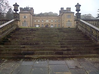
Aske Hall is a Georgian country house, with parkland attributed to Capability Brown, 1.5 miles (2.4 km) north of Richmond, North Yorkshire, England. It contains an impressive collection of 18th-century furniture, paintings and porcelain, and in its grounds a John Carr stable block converted into a chapel in Victorian times with Italianate decor, a Gothic-style folly built by Daniel Garrett circa 1745, coach house with carriage, Victorian stable block, walled garden, terraced garden and lake with a Roman-style temple. The hall and estate are currently owned by the Marquess of Zetland.

Colburn is a town, civil parish and electoral ward in North Yorkshire, England, 2 miles (3.2 km) west of Catterick. It had a population of 4,860 at the 2011 census, rising from 3,606 in 2001.
Appleton East and West is a civil parish in the former Richmondshire district of North Yorkshire, England. It contains the villages East Appleton and West Appleton, and had a population of 76 according to the 2001 census, remaining at less than 100 in the 2011 Census. From this date population details are maintained within the parish of Hornby. The settlement consists of two farms, with several water bodies in the area.

Caldwell is a village and civil parish in the Richmondshire district of North Yorkshire, England, close to the border with County Durham and approximately 10 miles west of Darlington. According to the 2011 UK census the parish had a population of 138, increasing from 115 at the 2001 census.

East Layton is a village and civil parish in the Richmondshire district of North Yorkshire, England, close to the border with County Durham and a few miles west of Darlington.

Gayles is a village and civil parish in the Richmondshire district of North Yorkshire, England. Gayles is established in the district ward of Gilling West. This small village consists of 80 households, with a total population of 180 according to the 2011 UK census. The area also includes two farms by the names of Gayles Hall Farm and Slip Farm. The village is roughly 10 miles (16 km) west of Darlington.
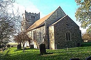
Gilling West is a village about 3.5 miles (5.6 km) north of Richmond in the Richmondshire district of North Yorkshire, England. It is located in the civil parish of Gilling with Hartforth and Sedbury. It is named "West" to distinguish it from Gilling East in Ryedale, some 32 miles away.

Thoralby is a village and civil parish in the Richmondshire district of North Yorkshire, England. It lies south of Aysgarth, is within a mile of both Newbiggin and West Burton and is in the Yorkshire Dales National Park. It is 23.5 miles (37.8 km) south-west of the county town of Northallerton.
Marske is a village and civil parish in the Richmondshire district of North Yorkshire, England, situated in lower Swaledale on the boundary of the Yorkshire Dales National Park, the village is approximately 5 miles (8 km) west of Richmond. According to the UK 2011 Census, the population of the parish of Marske, including New Forest was 127. The parish includes the hamlets of Applegarth, Clints, Feldom and Skelton.

Eppleby is a village and civil parish in the Richmondshire district of North Yorkshire, England. It is located about 7 miles (11 km) north of Richmond. According to the 2011 United Kingdom census, the population of the parish was 269.

Easby is a hamlet and civil parish in the Richmondshire district of North Yorkshire, England. It is situated near Richmond on the banks of the River Swale, approximately 12 miles (19 km) north west from the county town of Northallerton. The population taken by ONS was less than 100. Population information is included in the parish of Hudswell.

Hipswell is a village and civil parish in the Richmondshire district of North Yorkshire, England. The civil parish mainly comprises the northern part of Catterick Garrison. The village of Hipswell is at the eastern end of the civil parish, and effectively forms a suburb of Catterick Garrison.

Hudswell is a village and civil parish on the border of the Yorkshire Dales, in North Yorkshire, England. The population at the ONS Census 2011 was 353.

Crakehall is a village and civil parish in the Hambleton District of North Yorkshire, England, approximately 2 miles (3 km) west of Bedale. More known as Thomas Barkers home grounds. The village lies along the route of the A684 and is split into two parts by Bedale Beck, a tributary of the River Swale. The population was estimated at 630 in 2015. The north-west part is known as Little Crakehall, and the south-east part as Great Crakehall. It is 8.3 miles (13.4 km) west-south-west of the county town of Northallerton.

Eshton is a small village and civil parish in the Craven district of North Yorkshire, England. At the 2011 Census the population was less than 100 and is included in the civil parish of Flasby with Winterburn. In 2015, North Yorkshire County Council estimated the population to be 70. It is in the Yorkshire Dales and about 6 miles (9.7 km) south of Grassington.
Over Silton is a village and civil parish in the Hambleton district of North Yorkshire, England, about 6 miles (9.7 km) east of Northallerton and on the border of the North York Moors. The population taken at the 2011 Census was less than 100, and so detailed information is included in the civil parish of Nether Silton. The population was estimated to be 70 at the time of the 2011 census by North Yorkshire County Council. This had dropped to 60 by 2015.

Kirklington is a village in the English county of North Yorkshire close to the A1(M) motorway. Kirklington forms the major part of the civil parish of Kirklington-cum-Upsland.
Aughton is a village and former civil parish, now in the parish of Ellerton, in the East Riding of Yorkshire, England. It is situated approximately 7 miles (11 km) north-west of the market town of Howden and 9 miles (14 km) south-west of the market town of Pocklington. In 1931 the parish had a population of 100. On 1 April 1935 the parish was abolished to form Ellerton.
Aske is a civil parish in the former Richmondshire district of North Yorkshire, England. It contains 19 listed buildings that are recorded in the National Heritage List for England. Of these, two are listed at Grade I, the highest of the three grades, one is at Grade II*, the middle grade, and the others are at Grade II, the lowest grade. The most important building in the parish is Aske Hall, which is listed, and most of the other listed buildings are associated with it. These include structures close to the hall, including a stable block, and buildings in and around the park, including follies, lodges, gateways and a bridge. The other listed buildings are a milepost and a boundary marker.

