The Chinnor and Princes Risborough Railway is a preserved standard gauge heritage railway with its headquarters and main station at Chinnor in South Oxfordshire, England. It runs along the foot of the Chilterns escarpment. Although a few fields away it has since been given the nickname 'The Icknield Line' for its connection to the Lower Icknield Way.

Watlington is a small market town and civil parish about 7 miles (11 km) south of Thame in Oxfordshire, near the county's eastern edge and less than 2 miles (3 km) from its border with Buckinghamshire. The parish includes the hamlets of Christmas Common, Greenfield and Howe Hill, all of which are in the Chiltern Hills. The 2011 Census recorded the parish's population as 2,727.

Aston Rowant is a village, civil parish and former manor about 4+1⁄2 miles (7 km) south of Thame in South Oxfordshire, England. The parish includes the villages of Aston Rowant and Kingston Blount, and adjoins Buckinghamshire to the southeast. The 2011 Census recorded the parish's population as 793. The Lower Icknield Way passes through the parish southeast of the village.
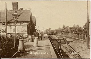
Watlington railway station in Oxfordshire was the terminus of the Watlington and Princes Risborough Railway and opened in 1872. Watlington station was not in Watlington itself, but in the parish of Pyrton half a mile from Watlington.
Granborough Road railway station was a station serving the village of Granborough, to the north of Quainton in Buckinghamshire, England.
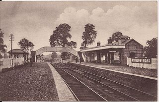
Winslow Road railway station served the village of East Claydon near Winslow to the north of Quainton in Buckinghamshire, England. It was the second station to serve the town after Winslow on the Varsity Line.
Lewknor is a village and civil parish about 5 miles (8 km) south of Thame in Oxfordshire.The civil parish includes the villages of Postcombe and South Weston. The 2011 Census recorded the parish's population as 663.

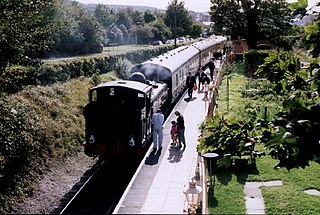
Chinnor railway station in Oxfordshire is on the line of the former Watlington and Princes Risborough Railway. The station was reopened by the Chinnor and Princes Risborough Railway Association in 1994 after a period of disuse.

Ardley railway station was a railway station serving the village of Ardley in Oxfordshire, England. It was on what is now known as the Chiltern Main Line, south of Ardley Tunnel.

Aynho Park was a railway station serving the village of Aynho in Northamptonshire, England. It was on what is now known as the Chiltern Main Line.
Blackthorn railway station was a railway station serving the village of Blackthorn, Oxfordshire, England. It was on what is now known as the Chiltern Main Line.

Lewknor Bridge Halt railway station was a halt on the Watlington and Princes Risborough Railway which the Great Western Railway opened in 1906 to serve the Oxfordshire village of Lewknor. The opening of the halt was part of a GWR attempt to encourage more passengers on the line at a time when competition from bus services was drawing away patronage.

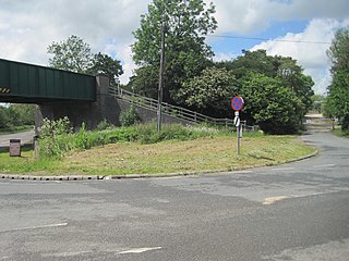
Kingston Crossing Halt railway station was a halt on the Watlington and Princes Risborough Railway which the Great Western Railway opened in 1906 to serve the Oxfordshire village of Kingston Blount. The opening of the halt was part of a GWR attempt to encourage more passengers on the line at a time when competition from bus services was drawing away custom.

Henton is a hamlet in Oxfordshire, about 3 miles (5 km) west of Princes Risborough in Buckinghamshire. Henton is in the civil parish of Chinnor, just off the Icknield Way, which has been a road since the Iron Age.

Bledlow Bridge Halt railway station was a halt on the Watlington and Princes Risborough Railway which the Great Western Railway opened in 1906 to serve the Buckinghamshire village of Bledlow. The opening of the halt was part of a GWR attempt to encourage more passengers on the line at a time when competition from bus services was drawing away patronage.

Wainhill Crossing Halt was a halt on the Watlington and Princes Risborough Railway which the Great Western Railway opened in 1925 to serve the Oxfordshire hamlet of Wainhill. The opening of the halt was part of a GWR attempt to encourage more passengers on the line at a time when competition from bus services was drawing away patronage.

Bledlow railway station was an intermediate station on the Wycombe Railway which served the Buckinghamshire village of Bledlow from 1862 to 1963. It was one of two stations to serve the village, the other being Bledlow Bridge Halt on the Watlington and Princes Risborough Railway, which was 0.75 miles (1.21 km) to the south and closer to the village. The possibility of reopening the line through Bledlow, which is now part of a long-distance footpath, has been explored by Chiltern Railways, the franchise holder for the Chiltern Main Line which runs through Princes Risborough.

Towersey Halt railway station was an intermediate station on the Wycombe Railway which served the Oxfordshire village of Towersey from 1933 to 1963. The opening of the halt was part of an attempt by the Great Western Railway to encourage more passengers on the line at a time when competition from bus services was drawing away patronage. The possibility of reopening the line through Towersey Halt, which is now part of a long-distance footpath, has been explored by Chiltern Railways, the franchise holder for the Chiltern Main Line which runs through Princes Risborough.

Horspath Halt was an intermediate station on the Wycombe Railway which served the Oxfordshire village of Horspath from 1908 to 1915, and then from 1933 to 1963. The opening of the halt was part of an attempt by the Great Western Railway to encourage more passengers on the line at a time when competition from bus services was drawing away patronage. The possibility of reopening the line through Horspath Halt has been explored by Chiltern Railways, the franchise holder for the Chiltern Main Line which runs through Princes Risborough.

Morris Cowley was an intermediate station on the Wycombe Railway which served the small town of Cowley, just outside Oxford, from 1908 to 1915, and again from 1928 to 1963. The station originally opened as part of an attempt by the Great Western Railway to enable to have more passengers access to the line, at a time when competition from bus services was drawing away patronage. The line through Morris Cowley remains open for the purposes of serving the BMW Mini factory, although the possibility of reinstating passenger services has been explored by Chiltern Railways, the franchise holder for the Chiltern Main Line which runs through Princes Risborough.
