Related Research Articles
The Vale of White Horse is a local government district of Oxfordshire in England. It was historically a north-west projection of Berkshire. The area is commonly referred to as the 'Vale of the White Horse'. It is crossed by the Ridgeway National Trail in its far south, across the North Wessex Downs AONB at the junction of four counties. The northern boundary is defined by the River Thames. The name refers to Uffington White Horse, a prehistoric hill figure.

Bow Road is a closed railway station in Bow, East London, that was opened in 1876 on the Bow Curve branch line by the Great Eastern Railway (GER).

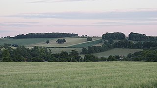
The Berkshire Downs are a range of chalk downland hills in southern England, part of the North Wessex Downs Area of Outstanding Natural Beauty. The Berkshire Downs are wholly within the traditional county of Berkshire, although split between the current ceremonial counties of Berkshire and Oxfordshire. The western parts of the downs are also known as the Lambourn Downs.
Uffington is a village and civil parish in Oxfordshire, about 4 miles (6.4 km) south of Faringdon and 6 miles (10 km) west of Wantage. The 2011 Census recorded the parish's population as 783. Lying within the historic county boundaries of Berkshire, in 1974 it was transferred for local government purposes to Oxfordshire under the Local Government Act 1972. Uffington is most commonly known for the Uffington White Horse hill figure on the Berkshire Downs in the south of the parish.

Wantage is a constituency in Oxfordshire represented in the House of Commons of the Parliament of the United Kingdom by Conservative MP David Johnston.

Kings Langley railway station is almost under the M25 motorway near Junction 20. It serves the village of Kings Langley, and the nearby villages of Abbots Langley and Hunton Bridge. The station is 21 miles (34 km) north west of London Euston on the West Coast Main Line. The station and all services calling at the station are operated by London Northwestern Railway.

The Bellgrove rail accident occurred on 6 March 1989 when two passenger trains collided near Bellgrove station, Glasgow, United Kingdom. Two people were killed and 53 were injured. The cause was driver error, with a signal being passed at danger. The layout of a junction was a contributory factor.
There was a rail crash near Welwyn Garden City railway station in Hertfordshire, England, in 1935 which killed fourteen people, and another in 1957 with one fatality.

Ash railway station serves the village of Ash in Surrey, England. The station is served by South Western Railway, who manage the station, and by Great Western Railway. It is situated on the Ascot to Guildford line and the North Downs Line, 36 miles 34 chains (58.6 km) from London Waterloo.

Kingham railway station in Oxfordshire, England, is between the Oxfordshire village of Kingham and the Gloucestershire village of Bledington, to which it is closer. It is also the closest station to the town of Chipping Norton.
There are 22 disused railway stations on the Bristol to Exeter line between Bristol Temple Meads and Exeter St Davids. The line was completed in 1844 at which time the temporary terminus at Beambridge was closed. The most recent closure was Tiverton Junction which was replaced by a new station} on a different site in 1986. 12 of the disused stations have structures that can still be seen from passing trains.
There are seventeen disused railway stations on the Cornish Main Line between Plymouth in Devon and Penzance in Cornwall, England. The remains of nine of these can be seen from passing trains. While a number of these were closed following the so-called "Beeching Axe" in the 1960s, many of them had been closed much earlier, the traffic for which they had been built failing to materialise.
The Norton Fitzwarren rail crash occurred on 11 November 1890, at Norton Fitzwarren station on the Great Western Railway, approximately two miles south-west of Taunton in Somerset. A special boat train carrying passengers from Plymouth to Paddington collided with a goods train that was being shunted on the main line. Ten passengers were killed, and eleven people were seriously injured. Another significant accident occurred at Norton Fitzwarren in 1940.

Steventon railway station was built when the Great Western Railway extended their main line from Reading to the village of Steventon, opening the line on 1 June 1840. Two months later, on 20 July, it was extended to Faringdon Road, and in December of that year, to Swindon.

Challow railway station is a former railway station about 2 miles (3 km) south of Stanford in the Vale on the A417 road between Wantage and Faringdon. It is named after the villages of West Challow and East Challow, which are 1.5 miles (2.4 km) and 2.5 miles (4 km) southeast of the former station.

Uffington and Barnack was a railway station in the Soke of Peterborough serving the villages of Uffington, Barnack and Bainton.

The Dunstable Branch Lines were railway branch lines that joined the English town of Dunstable to the main lines at Leighton Buzzard and Welwyn. The two lines were under separate ownership and joined just east of the Dunstable North station.
The Faringdon branch was a 3+1⁄2-mile-long branch line from Uffington Station to Faringdon in the Vale of White Horse, in Oxfordshire.

Faringdon railway station is a closed stone and brick built railway station that served the market town of Faringdon, in Oxfordshire, England and was on the Faringdon branch line.
Faringdon was a rural district in the administrative county of Berkshire from 1894 to 1974.
References
- ↑ "New Popular Edition Maps".
- ↑ MacDermot, E.T. (1931). History of the Great Western Railway, vol. II: 1863-1921. Paddington: Great Western Railway. pp. 6, 72. OCLC 55853736.
- ↑ "Oxfordshire villages: Uffington". www.oxfordshirevillages.co.uk. Archived from the original on 7 September 2008.