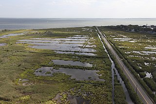
The Shiawassee National Wildlife Refuge is a 9,870.35 acres (39.9439 km2) National Wildlife Refuge in Saginaw County managed by the United States Fish and Wildlife Service. It is located in the central portion of the lower peninsula of the U.S. state of Michigan, approximately 25 miles (40 km) south of the Saginaw Bay in Lake Huron and five miles (8 km) south of the city of Saginaw in the county's Spaulding and James townships. It was established in 1953 to provide habitat for migratory waterfowl.

Huron Wetland Management District is located in the U.S. state of South Dakota and includes 17,518 acres (70.89 km2). The refuge borders the Missouri River on the east and is managed by the U.S. Fish and Wildlife Service. Huron WMD covers eight counties in east-central South Dakota. The topography of this area ranges from flat, gently rolling drift prairie to the Missouri Coteau hills in the western end of the district. The district lies in the midst of the world-renowned Prairie Pothole Region.

Madison Wetland Management District is located in the U.S. state of South Dakota and includes 129,700 acres (524 km2). 38,500 acres (155 km2) is owned by the U.S. Government while the remaining area is protected through easements in agreement with the state and other entities. The refuge is managed by the U.S. Fish and Wildlife Service. The wetlands are a part of the Prairie Pothole Region, well known to be an outstanding natural resource area that is vital for migratory bird species. As the Great plains were being plowed under, conservationists groups worked towards ensuring wetlands would be preserved to protect these areas. Now known as Waterfowl Production Areas, preservation of this region helps to ensure a sustainable population of hundreds of migratory bird species and other plant and animal species dependent on this ecosystem.

Sand Lake National Wildlife Refuge is located in the northeastern part of the U.S. state of South Dakota and is administered by the U.S. Fish and Wildlife Service. Created in 1935, it is a wetlands of international importance and a Globally Important Bird Area. Over 260 bird species are found in the refuge, including many migratory bird species and the world's largest breeding colony of Franklin's gulls.

Arrowwood Wetland Management District is located in the U.S. state of North Dakota. Arrowwood WMD is a part of the Arrowwood National Wildlife Refuge Complex, and is managed by the U.S. Fish and Wildlife Service. The district consists of 28 Waterfowl Production Areas, 314 Wetland easements, one easement refuge known as Johnson Lake National Wildlife Refuge and another four easements through the Farmers Home Administration, altogether totalling 28,922 acres (117 km2).

Chase Lake Wetland Management District is located in the U.S. state of North Dakota. The district is located in what is known as the prairie–potholes region of lakes and ponds, which were left behind by the retreat of glaciers at the end of the last ice age. Hundreds of waterfowl production areas, Wildlife Development Areas, wetland easements, grassland easements and the easement refuge known as Halfway Lake National Wildlife Refuge, are managed by the district. The district is a part of the Arrowwood National Wildlife Refuge Complex.

The Chase Lake Prairie Project is an effort to restore and protect the largest remaining region in the lower 48 states for waterfowl production. Located in U.S. state of North Dakota and consisting of 5,500,000 acres (22,000 km2) spread across 11 counties, this region is composed of thousands of lakes and ponds and grassland prairie. 97% of the land area is privately owned, with the U.S. Fish and Wildlife Service working with landowners to protect wetlands and associated prairie regions in a collaborative effort to ensure the region continues to provide habitat for the millions of birds and other wildlife that are dependent on the ecosystem.

The Valley City Wetland Management District is located in the U.S. state of North Dakota and consists of 76,000 acres (307 km2). The wetland district is a substation of the Arrowwood National Wildlife Refuge Complex, overseen by the U.S. Fish and Wildlife Service. 82 waterfowl production areas and four separate national wildlife refuges which are privately owned are in turn managed by the wetland district as easement refuges. The wetland district is in portions of 5 counties in the Prairie Pothole Region that was created by the retreat of glaciers 12,000 years ago, during the last glacial maximum. One third of the protected lands are wetlands with the balance consisting of prairie.

The Tomahawk National Wildlife Refuge is located in the U.S. state of North Dakota and consists of 440 acres (1.78 km2). Tomahawk NWR is a privately owned easement refuge, managed with by the U.S. Fish and Wildlife Service. The refuge was established to protect habitat for migratory bird species, white-tail deer and other mammals. Valley City Wetland Management District oversees the refuge, which in turn is a part of the Arrowwood National Wildlife Refuge Complex. The refuge can be accessed from North Dakota Highway 1, and is one mile (1.6 km) east of the town of Rogers, North Dakota.

Audubon National Wildlife Refuge is a 14,739-acre (5,965 ha) National Wildlife Refuge in the U.S. state of North Dakota. The refuge is managed by the U.S. Fish and Wildlife Service and is the centerpiece of the Audubon National Wildlife Refuge Complex, which includes numerous other refuges in the region. Originally designated as the Snake Creek National Wildlife Refuge in 1955, the refuge was renamed in 1967 in honor of the artist and naturalist John James Audubon. Most of the refuge area is a lake known as Audubon Lake which is managed by the U.S. Army Corps of Engineers.

Lake Ilo National Wildlife Refuge (NWR) is located in the U.S. state of North Dakota and is managed from Audubon National Wildlife Refuge by the U.S. Fish and Wildlife Service. The refuge consists of Lake Ilo, surrounding wetlands and some upland range, providing habitat for hundreds of species of birds, and numerous fish and mammal species. An average of over 16 inches (40 cm) of precipitation falls annually, supporting a prairie ecosystem.

The Lostwood Wetland Management District is located in the U.S. state of North Dakota and extends from the Canada–United States border to the neighboring state of Montana. The district consists almost exclusively of privately owned property, and landowners work cooperatively with the U.S. Fish and Wildlife Service to manage the land to maximize natural and agricultural needs. Hundreds of small bodies of water, wetlands and uplands are set aside to increase bird productivity and provide habitat for native animals and plants. The district comprises various areas spread throughout northwestern North Dakota which include waterfowl production areas, wetland easements, grassland easements, and easement refuges. The properties are located in Mountrail and part of Ward County, North Dakota.
The San Luis National Wildlife Refuge Complex is located in the northern San Joaquin Valley, within Merced County and Stanislaus County of California. The complex, with four federal National Wildlife Refuges, is managed by the U.S Fish & Wildlife Service.

Hamden Slough National Wildlife Refuge is a National Wildlife Refuge of the United States in Minnesota. Eastern hardwood forests stretching from the Atlantic seaboard give way to the western prairie at the area, in Audubon Township, near Audubon, Minnesota. Prior to settlement, its diverse vegetation was attractive to wildlife: waterfowl, upland birds, bison, wolves, and other prairie wildlife. When fully restored, the refuge will provide the largest contiguous block of wetland prairie habitat in the region, encompassing nearly 6,000 acres (24 km2).

Seatuck National Wildlife Refuge is located in the hamlet of Islip, New York, on the south shore of Long Island. It is managed by the U.S. Fish and Wildlife Service as part of the Long Island National Wildlife Refuge Complex. The refuge consists of 196 acres (0.79 km2) bordering the Great South Bay, separated from the Atlantic Ocean only by Fire Island. Situated in a heavily developed urban area along Champlin Creek, the refuge is an oasis for many species of migratory birds and waterfowl.

The John H. Chafee National Wildlife Refuge is a national wildlife refuge of the United States, located along the Narrow River on the southern coast of Rhode Island.

Slade National Wildlife Refuge is a 3,000-acre (12 km2) National Wildlife Refuge in Kidder County, North Dakota. It was established in 1941 when the property was donated by G.T. Slade, a Northern Pacific Railroad executive. It is managed under the Long Lake National Wildlife Refuge. It contains Harker Lake and Upper Harker Lake.
Devils Lake Wetland Management District is located in the heart of the Prairie Pothole Region of the United States. The District was established in 1962 to purchase and protect wetland habitat for migratory waterfowl and other wildlife in northeastern North Dakota. One of the primary objectives of Devils Lake Wetland Management District is to provide wetland and grassland habitat for waterfowl in the spring and summer for nesting and feeding. The other primary objective is to provide migration habitat for waterfowl in the spring and fall.

Located in south-central North Dakota, Kulm Wetland Management District was established in 1971. Located in the Prairie Pothole Region of North America, Kulm Wetland Management District provides breeding, nesting, and brood rearing areas for many species of waterfowl and other migratory birds. The District currently manages 201 waterfowl production areas that total 45,683 acres (184.87 km2), 3 national wildlife refuges that are easement refuges, and 120,000 acres (490 km2) of wetland and grassland easements. The District's headquarters is in Kulm, North Dakota.

Long Lake Wetland Management District encompasses three counties in south-central North Dakota, an area famed for its wealth of waterfowl-producing potholes and native prairie grasslands. Headquarters for the Wetland Management District is located in the Long Lake National Wildlife Refuge office near Moffit, North Dakota, which is about 35 miles southeast of Bismarck. Topographical landforms of the area include Missouri Coteau and Missouri River Slope. Precipitation averages just under 16 inches per year. Approximately 68 percent of the land in the three county area remains virgin sod - native mixed-grass prairie. The dominant land use is cattle grazing. The Coteau wetlands found in the northeastern portion of the Wetland Management District are classic prairie potholes of various sizes and types that are prime duck production habitat. These areas, when wet, are very productive. Soils in this area are generally deep and quite productive. Due to the rolling nature of the landscape on the Coteau, a lot of the land is also characterized as highly erodible. Conversely, many of the wetlands on Missouri River Slope portion of the Wetland Management District are large semi-permanent and permanent alkali wetlands. There are 21 wetland sites on the Missouri River Slope that have a history of periodic avian botulism outbreaks. These areas occasionally present localized problems for significant numbers of migratory birds. Soils on the Missouri River Slope are characteristically shallow with high proportions of sand and gravel. Much of the land is highly erodible. Since 1985, substantial land acreage in the three county area that was once farmed has been retired to Conservation Reserve Program grasslands. The program has assisted in restoring waterfowl populations for many species in the Wetland Management District which exceed the highest level ever recorded since surveys began.


