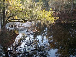
Singletary Lake State Park is a North Carolina state park in Bladen County, North Carolina in the United States. Located near Elizabethtown, it covers 1,221-acre (4.94 km2), including Singletary Lake, one of the largest Carolina bays. Singletary Lake State Park is southeast of Elizabethtown on North Carolina Highway 53 in North Carolina's Coastal Plain region. It serves primarily as a group camp but is open on a limited basis for year-round recreation, including hiking, fishing and observing nature.

Pokagon State Park is an Indiana state park in the northeastern part of the state, near the village of Fremont and 5 miles (8 km) north of Angola. It was named for the 19th-century Potawatomi chief, Leopold Pokagon, and his widely known son, Simon Pokagon, at Richard Lieber's suggestion. The 1,260-acre (5.1 km2) park has an inn, camping facilities, and a staff of full-time naturalists.

Meramec State Park is a public recreation area located near Sullivan, Missouri, about 60 miles from St. Louis, along the Meramec River. The park has diverse ecosystems such as hardwood forests and glades. There are over 40 caves located throughout the park, the geology of which is a mixture of limestone and dolomite. The most famous is Fisher Cave, located near the campgrounds. The park borders the Meramec Conservation Area.

Fort Abraham Lincoln State Park is a North Dakota state park located 7 miles (11 km) south of Mandan, North Dakota, United States. The park is home to the On-A-Slant Indian Village and reconstructed military buildings including the Custer House.
O'Leno State Park is a Florida State Park located on the Santa Fe River six miles north of High Springs on U.S. 441. Many facilities at the park were built by the Civilian Conservation Corps in the 1930s.

St. Croix State Park is a state park in Pine County, Minnesota, USA. The park follows the shore of the St. Croix River for 21 miles (34 km) and contains the last 7 miles (11 km) of the Kettle River. At 33,895 acres (13,717 ha) it is the largest Minnesota state park. It was developed as a Recreational Demonstration Area in the 1930s, and is one of the finest surviving properties of this type in the nation. 164 structures built by the Civilian Conservation Corps and the Works Progress Administration survive, the largest collection of New Deal projects in Minnesota. As a historic district they were listed on the National Register of Historic Places and proclaimed a National Historic Landmark in 1997.

Cross Ranch State Park is a public recreation area covering 589 acres (238 ha) on the west bank of the Missouri River in Oliver County, North Dakota. The state park is located 9 miles (14 km) south of Washburn and 22 miles (35 km) east of Center. It lies adjacent to the 6,000-acre (2,400 ha) Cross Ranch Nature Preserve, which features a roaming herd of more than 200 adult bison.

DeSoto State Park is a public recreation area located on Lookout Mountain 8 miles (13 km) northeast of Fort Payne, Alabama. The state park covers 3,502 acres (1,417 ha) of forest, rivers, waterfalls, and mountain terrain. It borders the Little River, which flows into the nearby Little River Canyon National Preserve. The 104-foot-tall (32 m) DeSoto Falls, the state's highest waterfall, is found in a separate part of the park 6 miles (9.7 km) north of the main park.

Fort Ransom State Park is a public recreation area located in the Sheyenne River valley two miles north of the town of Fort Ransom in Ransom County, North Dakota. The state park preserves two homesteader farms: the Bjone House and the Andrew Sunne farm. The park sits along the Sheyenne Valley National Scenic Byway, the first route in North Dakota to be given this designation.
Lake Metigoshe State Park is a public recreation area occupying 1,551 acres (628 ha) on the shores of Lake Metigoshe in the Turtle Mountains, 14 miles northeast of Bottineau, North Dakota, on the Canada–US border. The state park lies adjacent to the southwest corner of the much larger Turtle Mountain Provincial Park in Manitoba. A small portion of the lake extends northward into the Rural Municipality of Winchester but is not part of either park.

Roaring River State Park is a public recreation area covering of 4,294 acres (1,738 ha) eight miles (13 km) south of Cassville in Barry County, Missouri. The state park offers trout fishing on the Roaring River, hiking on seven different trails, and the seasonally open Ozark Chinquapin Nature Center.

Little Missouri State Park is a public recreation area covering nearly 4,600 acres (1,900 ha) along the Little Missouri River, near the river's confluence with Lake Sakakawea, located approximately 12 miles (19 km) due north of Killdeer, North Dakota. Much of the state park consists of badlands terrain that is only accessible by trail. The park has about 47 miles (76 km) of trails as well as campgrounds for hiking and equestrian use. The majority of the park's area is managed under lease from federal and private owners.

The George Washington State Forest is a state forest located in Itasca, Koochiching, and Saint Louis counties, Minnesota. The forest was established and named after George Washington in 1931, the first President of the United States, to commemorate the bicentennial of his birth. The forest borders the Chippewa National Forest and completely environs the Scenic State Park to the west, and borders the Sturgeon River State Forest and McCarthy Beach State Park to the east. The Taconite State Trail passes through the forest.

Icelandic State Park is a public recreation area located on Lake Renwick five miles (8.0 km) west of Cavalier in Akra Township, Pembina County, North Dakota. The state park's 912 acres (369 ha) include the Pioneer Heritage Center and the Gunlogson Homestead and Nature Preserve.

Fort Stevenson State Park is a public recreation area located on a peninsula on Lake Sakakawea four miles (6.4 km) south of the community of Garrison in McLean County, North Dakota. The state park's 549 acres (222 ha) include a partial reconstruction of Fort Stevenson, the 19th-century Missouri River fort from which the park takes its name. The site of the original fort lies about two miles southwest, below the waters of Lake Sakakawea.
Sully Creek State Park is a public recreation area located along the eastern banks of the Little Missouri River about 2 miles (3.2 km) south of Medora in Billings County, North Dakota. The state park is used for camping, horse camping, and canoeing. It was created in 1970.
Pembina Gorge State Recreation Area is a unit of the North Dakota state park system located along the Pembina River that provides a 12-mile (19 km) looped trail for riding ATVs, dirt bikes, and other forms of off-road vehicles. Non-motorized use by equestrians, mountain bikers, and hikers is also allowed. In 2014 plants were collected in the Pembina Gorge. The final count was 209 species, which includes prior collections.

The South Dakota Department of Game, Fish, and Parks (GFP) is the U.S. State of South Dakota's State Agency charged with the management of the state's public recreational and outdoor resources. The GFP manages the 13 State Parks and 43 State Recreation Areas within the South Dakota State Parks System, totaling over 96,000 acres of public lands. The agency manages the hunting of game and the state's fisheries, manages several wildlife management areas and game production areas to restore or establish habitat for a variety of species. The agency conducts public outdoor education programs, typically focusing on hunting and boating safety. The department issues hunting and fishing licenses along with issuance of boat registrations. The agency is also charged with enforcement of fish and game laws, including invasive species regulations. The agency is headquartered in Pierre, South Dakota.
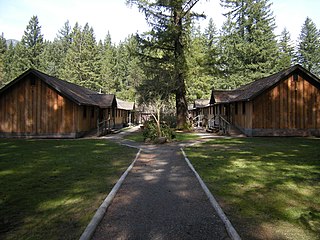
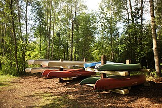
Camp North Bend, also known as Camp Waskowitz, is a 9 1⁄2 acre complex of wood frame buildings. Constructed by and for the Civilian Conservation Corps (CCC) in 1935, it was added to the National Register of Historic Places in 1993. It is the only intact example of CCC work camp design and construction in King County, Washington. The site is now used by Highline School District for an outdoor school program focused on environmental education.