South Goa district is one of two districts that together constiitue the state of Goa, India, within the region known as the Konkan. It is bounded by North Goa district to the north, the Uttara Kannada district of Karnataka state to the east and south, while the Arabian Sea forms its western coast.
Bangalore Rural district is one of the 31 districts in Karnataka, India. It was formed in 1986, when Bangalore District was divided into Bangalore Rural and Bangalore Urban. Presently in Bangalore Rural district, there are 4 talukas: Devanahalli, Nelamangala, Doddaballapura, Hoskote. It has 20 hoblies, 294 villages, 3 towns, 2 tier-three cities, administered by 66 Village Panchayats , 3Town Municipal Councils (Purasabes) and 2 City Municipal Councils (Nagarsabes).
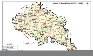
Shahapur is a city and taluka headquarter located in the Yadgir district of Indian state of Karnataka. Shahapur is 597 km north of Bangalore and well connected by road to Gulbarga (70 km), Hyderabad (240 km), Bidar (160 km), Raichur (90 km) and Yadgir (32 km).

Bidar district is the northernmost part of the Karnataka state in India. The administrative headquarters of district is Bidar city. Geographically, it resembles the "Crown of the State", occupying its northeastern end. It is bounded by Kamareddy and Sangareddy districts of Telangana state on the eastern side, Latur and Osmanabad districts of Maharashtra state on the western side, Nanded district of Maharashtra state on the northern side and Kalaburagi district on the southern side.

Kalaburagi district, formerly known as Gulbarga district, is one of the 31 districts of Karnataka state in southern India. Kalaburagi city is the administrative headquarters of the district. The district is the headquarters of Kalaburagi division.
Bagalakote, is a city in the state of Karnataka, India, which is also the headquarters of Bagalakote district. It is situated on branch of River Ghataprabha about 481 km (299 mi) northwest of state capital Bengaluru, 410 km (255 mi) southwest of Hyderabad, and about 570 km (354 mi) southeast of Mumbai. The population of the urban agglomeration was 111,933 according to the provisional results of 2011 national census of India, and the city is spread over an area of 49.06 square kilometres (18.94 sq mi) with an average elevation of 532 m (1,745 ft) above MSL.
Bhalki is a town in Bidar district in the Indian state of Karnataka.It is 30 km from Bidar.It is the headquarters of Bhalki taluka panchayat.It is well connected by roadways and railways The karanja river one of the main river of Bidar district flows through bhalki taluka.
Chincholi is a panchayat town and a taluka in Kalaburagi district in the state of Karnataka, India.
Chitagoppa is a taluka and town in Bidar district of Karnataka. Up until 2017, the city was under the administration of Humnabad. Chitguppa is divided into 23 wards. It is 15 kilometres (9.3 mi) from Humnabad and 53 kilometres (33 mi) from Bidar. The city is known for having the largest marketplace in the Bidar district and its corn production.It shares border with Kalaburagi district.The nearest highway is NH-65 which passes through Chitguppa taluk.
Kinathukadavu, meaning Pass of the Well, is a town panchayat suburb of Coimbatore city and taluk in Coimbatore district in the Indian state of Tamil Nadu. It is along the National Highway 209 and is 23 kilometres (14 mi) from Gandhipuram heart of Coimbatore city and 20.5 kilometres (13 mi) from Pollachi town.
Koratagere is a Panchayat Town in Tumkur district in the Indian state of Karnataka.
Pavagada or Pamukonda is a taluk in the Tumkur district in Karnataka, India. Historically it was part of the Mysore kingdom. Though it is geographically connected to Chitradurga district inside state of Karnataka, it comes under Tumkur district. It is 157.8 km from state capital of Bengaluru. Uttara Pinakini river flows into this Taluk. Pavagada Taluk falls on the border of Karnataka, hence a majority of the population are bilingual speaking Kannada and Telugu. The town is famous for its fort located on the hill, Kote Anjaneya temple at the foothills and also the temple of Sri Shani Mahatma.
Joida is a town located in the Uttara Kannada district in the Indian state of Karnataka. The town is the headquarters of the eponymous taluk. Earlier it was known as Supa taluka but as Supa village got submerged due to dam built across river Kali, Joida taluka came into existence. Joida town has a Post office, branch of nationalised banks and a Police station.
Bhatambra is a village in the southern state of Karnataka, India. It is located in the Bhalki taluk of Bidar district in Karnataka.
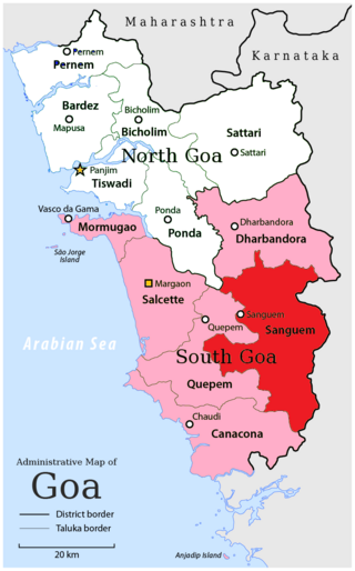
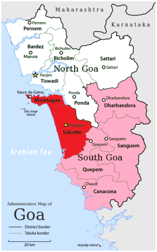
Sanguemtaluka is an administrative region of Goa state, India.

Pondataluka is a subdivision of the district of South Goa, in the Indian state of Goa. Its administrative headquarters is the township of Ponda.
Naigaon is a town and taluka in Nanded district of Maharashtra state in India. Naigaon (Bz.) is located 41.2 km south of the district headquarters city of Nanded and 60 km west from neighboring city of Nizamabad in Telangana State. Naigaon lies on MSH - 6. It is approximately 600 km from the State capital Mumbai. It is the Center of Naigaon Taluka. Naigaon is one of the rapidly growing towns in the Nanded District. The economy is primarily based on agriculture and related business.
Jat is a town and taluka headquarters in Miraj subdivision of Sangli district in southern Maharashtra.
Bantwal taluk is a taluk of Dakshina Kannada district. The headquarters is the town of Bantwal, an eastern suburb of Mangalore.
Deulgaon, commonly known as "Deulgaon Dhudhate" is a village located in Purna taluka of Parbhani district, in state of Maharashtra.


