Trastevere is the 13th rione of Rome: it is identified by the initials R. XIII and it is located within Municipio I. Its name comes from Latin trans Tiberim, literally 'beyond the Tiber'.
Pigna[ˈpiɲɲa] is the 9th rione of Rome, identified by the initials R. IX, and belongs to the Municipio I. The name means "pine cone" in Italian, and the symbol of the rione is the colossal bronze pine cone, that stand above the Pigna. The fountain, that was initially located in the Baths of Agrippa, now decorates a vast niche in the wall of the Vatican facing the Cortile della Pigna, located in Vatican City.

Borgo is the 14th rione of Rome, Italy. It is identified by the initials R. XIV and is included within Municipio I.

Sallustiano is the 17th rione of Rome, identified by the initials R. XVII. It is located within the Municipio I and the name refers to the ancient Gardens of Sallust, which were located here.

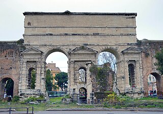
Castro Pretorio is the 18th rione of Rome (Italy), identified by the initials R. XVIII, and it is located within the Municipio I. The rione takes its name by the ruins of the Castrum Praetorium, the barracks of the Praetorian Guard, included in the Aurelian Walls.

Celio is the 19th rione of Rome, identified by the initials R. XIX, and is located within the Municipio I.

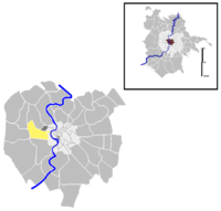
Campo Marzio is the 4th rione of Rome, identified by the initials R. IV. It belongs to the Municipio I and covers a smaller section of the area of the ancient Campus Martius. The logo of this rione is a silver crescent on a blue background.
Primavalle is the 27th quartiere of Rome, identified by the initials Q. XXVII. It is part of the Municipio XIV.

Villa Sciarra is a park in Rome named for the villa at its centre. It is located between the neighborhoods of Trastevere, Gianicolo and Monteverde Vecchio.

Ostiense is the 10th quartiere of Rome, identified by the initials Q. X.

Santa Maria delle Grazie alle Fornaci fuori Porta Cavalleggeri is a Baroque style, Roman Catholic parish and titular church located at Piazza di Santa Maria alle Fornaci, south of Vatican City and north of the San Pietro train station in the Aurelio quarter. It was made a cardinalate deaconry by Pope John Paul II on 25 May 1985, and assigned it to Cardinal Duraisamy Simon Lourdusamy, then Prefect of the Congregation for the Oriental Churches. The church became vacant on 2 June 2014 after the death of Cardinal Lourdusamy. On November 11, 2016 it was announced that Mario Zenari will succeed him.

Giuliano-Dalmata is the 31st quartiere of Rome, identified by the initials Q. XXXI. Its name refers to the Julian, Istrian and Dalmatian refugees that settled there in the postwar period.

Tor Cervara is the 7th zona of the Italian capital Rome, identified by the initials Z. VII. It belongs to the Municipio IV and has 13,975 inhabitants (2016). It is located in the east of the city, within the Grande Raccordo Anulare, and has an area of 5.9000 km².
Pinciano is the 3rd quartiere of Rome (Italy), identified by the initials Q. III. The name derives from the Pincian Hill. It belongs to the Municipio II.

Nomentano is the 5th quartiere of Rome (Italy), identified by the initials Q. V. The name derives from the ancient road Via Nomentana. It belongs to the Municipio II.

Tiburtino is the 6th quartiere of Rome (Italy), identified by the initials Q. VI. The name derives from the ancient road Via Tiburtina. It belongs to the Municipio II, Municipio IV and Municipio V.
Prenestino-Labicano is the 7th quartiere of Rome (Italy), identified by the initials Q. VII. The name derives from the ancient roads Via Prenestina and Via Labicana, today the initial stretch of Via Casilina. It belongs to the Municipio V and Municipio VII.
Tuscolano is the 8th quartiere of Rome (Italy), identified by the initials Q. VIII. The name derives from the ancient road Via Tuscolana. It belongs to the Municipio V and Municipio VII.
Gianicolense is the 12th quartiere of Rome (Italy), identified by the initials Q. XII. It belongs to the Municipio XI and Municipio XII. It takes its name from the Janiculum hill, which lies in the nearby rione Trastevere and whose western extremities correspond to the area of Monteverde.

Trionfale is the 14th quartiere of Rome (Italy), identified by the initials Q. XIV. The toponym also indicates the urban zone 19E of Municipio XIV.