Austerity Mountain is the second-highest point of the Adamant Range which is a subrange of the Selkirk Mountains, and it ranks as the fifth-highest peak in the Selkirks.[1] It is located 81km (50mi) northwest of Golden and 30km (19mi) north of Glacier National Park. Austerity is highly glaciated with the Granite Glacier to the north and Austerity Glacier to the south. Precipitation runoff and glacial meltwater from the mountain's slopes drains into tributaries of the Columbia River.[1]Topographic relief is significant as the summit rises 1,700 metres (5,600ft) above Austerity Creek in 5km (3.1mi) and 2,600 metres (8,500 feet) above Kinbasket Lake in 15km (9.3mi).
History
The first ascent of the summit was made on July 20, 1911, by Howard Palmer, Edward Holway, and Frederic King Butters.[6] This first ascent party named the peak "Mount Austerity."[7] Photographs of Austerity appeared in Howard Palmer's 1914 book, "Mountaineering and Explorations in the Selkirks".[4]
Based on the Köppen climate classification, Austerity Mountain is located in a subarctic climate zone with cold, snowy winters, and mild summers.[8] Winter temperatures can drop below −20°C with wind chill factors below −30°C. This climate supports multiple glaciers surrounding the peak.
Gallery
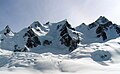
Austerity Mountain to right, with Adamant Mountain centered and The Stickle at far left
This page is based on this Wikipedia article Text is available under the CC BY-SA 4.0 license; additional terms may apply. Images, videos and audio are available under their respective licenses.