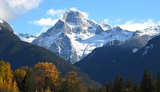
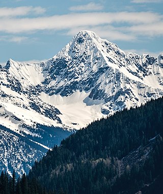
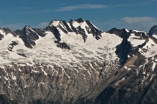
Mount Bute, also known as Bute Mountain, is a 2,810-metre (9,220-foot) mountain located in the Coast Mountains of British Columbia, Canada. Situated at the southern extreme of the Homathko Icefield, Mount Bute has an impressive 800-metre sheer granite west face, and Bute Glacier dominates the north aspect. This imposing mountain is visible from Waddington Harbour at the head of Bute Inlet, in a remote wilderness area that few visit. Its nearest higher peak is Mount Grenville, 13.0 km (8.1 mi) to the east-northeast. Mount Grenville is the highest summit of the icefield. Mount Bute is 63.0 km (39.1 mi) southeast of Mount Waddington, the highest peak of the entire Coast Mountains range.
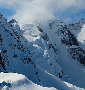
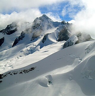
Oubliette Mountain is a 3,070-metre (10,072 ft) mountain summit located on the shared border of Jasper National Park in Alberta, and Mount Robson Provincial Park in British Columbia, Canada. Situated in the Tonquin Valley, Oubliette Mountain is part of The Ramparts in the Canadian Rockies. The nearest higher neighbor is Dungeon Peak, 1.0 km (0.62 mi) to the northwest. Not coincidentally, an oubliette is a secret dungeon with access only through a trapdoor in its ceiling. The mountain's descriptive name was coined by Cyril G. Wates.

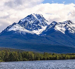
Mount Foresta is an 11,000+ ft multi-peak massif located in Wrangell–St. Elias National Park, in the Saint Elias Mountains of Alaska in the United States. Rising high above the lower western margin of the Hubbard Glacier, the summit of Mount Foresta is just over nine miles (14 km) from tidewater at Disenchantment Bay, 12 mi (19 km) northwest of Mount Seattle, 14.5 mi (23 km) southeast of Mount Vancouver, and 46 mi (74 km) north of Yakutat.

Mount Rexford is a prominent 2,329-metre (7,641-foot) mountain summit located in the Cascade Mountains of southwestern British Columbia, Canada. It is situated 3.5 km (2 mi) north of the Canada–United States border, 7 km (4 mi) west of Chilliwack Lake, and 5.5 km (3 mi) east of Slesse Mountain, which is its nearest higher neighbor. Precipitation runoff from the peak drains into Nesakwatch and Centre Creeks, both tributaries of the Chilliwack River. Originally known as Ensawkwatch, the mountain was named for an early settler in the area, Rexford, who had a cabin near Slesse Creek and had trap lines in the vicinity. The mountain has two subsidiary peaks known as the Nesakwatch Spires. The mountain's name was officially adopted on June 2, 1950, by the Geographical Names Board of Canada. Mount Rexford was first climbed in July 1951 by Herman Genschorek and Walt Sparling via the West Ridge.

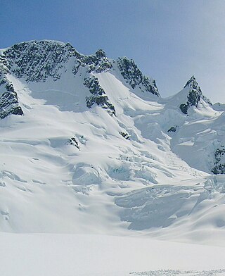
Gimli Peak is a 2,806-metre (9,206 ft) mountain summit located in the Valhalla Ranges of the Selkirk Mountains in British Columbia, Canada. Gimli Peak is the fourth-highest point in the Valhalla Ranges, with the highest being Gladsheim Peak, 2.7 km (1.7 mi) to the north. Its nearest higher peak is Midgard Peak, 1.8 km (1.1 mi) to the northwest. It is situated in southern Valhalla Provincial Park, immediately southwest of Mulvey Lakes, and 12 km (7.5 mi) west of Slocan and Slocan Lake. The name "Valhalla Mountains" first appeared in George Mercer Dawson's Geological Survey of Canada map published in 1890. Dawson applied names derived from Scandinavian mythology to several of the mountain ranges and peaks in Southern Kootenay. In keeping with the Valhalla theme, this peak was originally labelled "Mount Gimli" on a 1900 Geological Survey of Canada publication, and it was officially adopted April 29, 1998, by the Geographical Names Board of Canada as Gimli Peak. According to Norse mythology, Gimli is the place where the righteous survivors of Ragnarök are foretold to live. Based on the Köppen climate classification, Gimli Peak has a subarctic climate with cold, snowy winters, and mild summers. Winter temperatures can drop below −20 °C with wind chill factors below −30 °C. Precipitation runoff from the mountain drains into tributaries of the Slocan River.

Mount Green is a 2,692-metre (8,832-foot) mountain summit located in Glacier National Park, in the Selkirk Mountains of British Columbia, Canada. It is situated 4 km (2.5 mi) north-northwest of Mount Bonney, 10 km (6.2 mi) southwest of Rogers Pass, 52 km (32 mi) northeast of Revelstoke, and 44 km (27 mi) west of Golden. The mountain was named by Arthur Oliver Wheeler for Rev. William Spotswood Green (1847–1919), who explored, mapped, named, climbed, and wrote about the Selkirk Mountains. His book "Among the Selkirk Glaciers", published in 1890, introduced the world to the Selkirk Mountains. He is credited with recommending the location for a small chalet to the Canadian Pacific Railway that would grow to become the Chateau Lake Louise hotel, as well as making the first ascent of Mount Bonney. The mountain's name was officially adopted September 8, 1932, when approved by the Geographical Names Board of Canada. The first ascent of the mountain was made August 25, 1910, by Alexander A. McCoubrey and Ernest Feuz who climbed the south ridge and descended the north ridge.
Albert Peak is a 3,045-metre (9,990-foot) mountain summit located in British Columbia, Canada.
Whitesaddle Mountain is a summit located in British Columbia, Canada.
Mount Butters is a 3,141-metre (10,305-foot) mountain summit in British Columbia, Canada.

Mount Proteus is a 3,198-metre (10,492-foot) mountain summit in British Columbia, Canada.
Pequod Mountain is a 2,979-metre (9,774-foot) summit in British Columbia, Canada.
Moby Dick Mountain is a 3,154-metre (10,348-foot) summit in British Columbia, Canada.
Outrigger Peak is a 2,850-metre (9,350-foot) mountain summit in British Columbia, Canada.

Northpost Spire is a 2,911-metre (9,551-foot) peak in British Columbia, Canada.
Ygdrasil Mountain is a 2,960-metre (9,710-foot) mountain in British Columbia, Canada.

Houdini Needles is a 2,663-metre (8,737-foot) mountain in British Columbia, Canada.
Sentinel Peak is a 2,992-metre (9,816-foot) mountain in British Columbia, Canada.
Austerity Mountain is a 3,337-metre (10,948-foot) mountain in British Columbia, Canada.

Unicorn Mountain is a 3,010-metre (9,880-foot) mountain in British Columbia, Canada.
Pioneer Peak is a 3,245-metre (10,646-foot) mountain in British Columbia, Canada.