Related Research Articles
Kanchipuram district is one of the 38 districts in the state of Tamil Nadu in India. The area comprising the present day Kancheepuram district was earlier a part of Chingleput district. The original Chingleput district was split in 1997 into form the present day Kanchipuram and Tiruvallur districts.

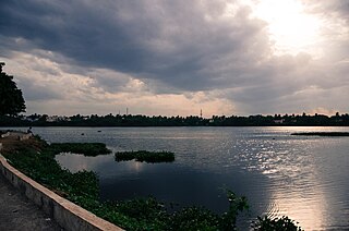
Avadi is a western suburb of Chennai, and the headquarters of Avadi taluk located within the Thiruvallur district of Tamil Nadu, India. Situated at about 22 kilometres (14 mi) from Chennai Central Railway Station, it is one of the four municipal corporations in the Chennai Metropolitan Area and is governed by the Avadi Municipal Corporation. It is surrounded by major defence establishments and is home to various universities and engineering colleges. The neighborhood is served by Avadi Railway Station of the Chennai Suburban Railway and just 7 km from the upcoming Karayanchavadi Metro of Chennai Metro Rail. As of 2011, Avadi had a population of 345,996, which is 10th most populous place in Tamil Nadu. It is home to the Heavy Vehicles Factory (HVF), Ordnance Factory Board (ODF) which houses Engine Factory and Combat Vehicles Research and Development Establishment (CVRDE). The lake in Avadi was known as Paaleripattu, which is now found only in very old land documents.
Tiruvallur district, also spelled as Thiruvallur district, is one of the 38 districts in the Indian state of Tamil Nadu. The fast developing city of Tiruvallur is the district headquarters. The district has a mixture of urban and rural characteristics. The eastern part of Tiruvallur district is dominated by urban characteristics while the Northern part of the district has influence of Andhra culture due to its position. In 2011, the district had a population of 3,728,104 with a sex-ratio of 987 females for every 1,000 males.

Chennai district, formerly known as Madras district, is one of the 38 districts in the state of Tamil Nadu, India. It is the smallest and the most densely populated district in the state. The district is coterminous with the city of Chennai, which is administered by the Greater Chennai Corporation. It is surrounded by Tiruvallur district in the north and the west, Kanchipuram district in the south-west, Chenglpattu district in the south, and the Bay of Bengal in the east.

Poonamallee is a town and suburb of Chennai, India under the Chennai Metropolitan Area. It was historically called Pushpagirimangalam, later renamed in Tamil as Poovirundhavalli, and now colloquially called as Poondhamalli. It is the headquarters of the Poonamallee taluk of the Tiruvallur district in the Indian state of Tamil Nadu. The nearest Railway station is at Avadi. It acts as the gateway to the city from its western side. It is a town with rich cultural heritage and also a fast-growing areas in the city. As of 2011, the town had a population of 57,224. There are plans to merge the areas under Poonamallee Municipality with Avadi Municipal Corporation.
Guduvancheri is a suburb located to the south of Chennai city, Tamil Nadu, India. It has a railway station on the Chennai Beach–Chengalpattu section of the Chennai Suburban Railway Network and is a municipality in Chengalpattu district, Tamil Nadu, India. It is also part of the Vandalur taluk and lies in the southern part of Chennai metropolitan area. It has a lake known as the Guduvancheri lake and Nandivaram lake. It serves as the connecting hub between Chennai and Chengalpattu. It also lies on the major highway connecting Chennai with Kanyakumari, the southernmost point of the state and the country.
Anakaputhur is a neighborhood in the city of Tambaram, situated within the Chennai Metropolitan Area, Tamil Nadu, India.
Madhavaram is a neighbourhood of Chennai, Tamil Nadu, India. Located in the northern part of Chennai, it is also a taluk in Chennai District and a zone in Greater Chennai Corporation. It is located in between Perambur and Kodungaiyur. As of 2011, the neighbourhood had a population of 119,105. The Chennai district was expanded on 16 August 2018 by transferring Madhavaram taluk from Tiruvallur district to Chennai district.
Ponneri is a town located in Chennai Metropolitan Area, Thiruvallur district in the Indian state of Tamil Nadu. It is located in Ponneri taluk. Ponneri is major destination for Andhra Pradesh people to buy goods. It is a part of the area Chennai Metropolitan Development Authority (CMDA) and a vital locality in Chennai Metropolitan Area.
The Chennai Metropolitan Development Authority (CMDA), formerly known as the Madras Metropolitan Development Authority (MMDA), is the nodal planning agency of Chennai in the Indian state of Tamil Nadu. The CMDA administers the Chennai Metropolitan Region, spread over an area of 5,904 km2 (2,280 sq mi) and covers the districts of Chennai, Thiruvallur, Chengalpattu, Ranipet and Kancheepuram. It was set up for the purposes of planning, co-ordination, supervising, promoting and securing the planned development of the Chennai Metropolitan Area. It coordinates the development activities of the municipal corporations, municipalities and other local authorities.
Greater Chennai Metropolitan Area, or simply the Chennai Metropolitan Area (CMA), is fourth-most populous metropolitan area in India and the 35th most populous in the world.
Thirumullaivoyal is a western neighbourhood of Chennai the capital of the India state of Tamil Nadu, under Avadi City Municipal Corporation Limits. It is located in the Chennai Metropolitan Area in Thiruvallur district, 3 km (1.9 mi) from Avadi and 3 km (1.9 mi) from Ambattur O.T Bus depot. The neighbourhood is served by Thirumullaivoyal railway station and Annanur Railway Station. The region was historically part of Thondaimandalam, a region in Chola Empire during 9th century CE.
Annanur is a western neighbourhood of Chennai, India. It is located near Ambattur and lies in Chennai District. It comes under the Avadi Municipal Corporation. It is located about 20 km from the city centre.
Cheyyur taluk is a taluk of Chengalpattu district of the Indian state of Tamil Nadu. The headquarters of the taluk is the town of Cheyyur.

Potheri is a rapidly-growing village locality in the South suburbs of the Metropolitan city Chennai. It is a town that comes under Maraimalai Nagar municipality of Chengalpattu taluk in the Chengalpattu district of Tamil Nadu, India and suburb of Chennai within Chennai Metropolitan Area. It is about 2.5 kilometers from Guduvancheri.The primary educational institutions located in Potheri are SRM Institute of Science and Technology and Valliammai Engineering College.

Avadi is a state assembly constituency in Tamil Nadu, India, newly formed after constituency delimitation. Its State Assembly Constituency number is 6. It consists of a portion of Avadi taluk and includes Avadi. It is included in the Thiruvallur parliamentary constituency. It is one of the 234 State Legislative Assembly Constituencies in Tamil Nadu.
Madhavaram taluk is a taluk of Chennai district in the Indian state of Tamil Nadu. The centre of the taluk is the neighbourhood of Madhavaram. The headquarters of the taluk is Tondiarpet division. And the taluk has been bifurcated from Ambattur taluk and on 2018 it has been annexed to Chennai district from tiruvallur by expanding Chennai city. And the taluk Has regions of Kathirvedu, Lakshmipuram, Madhavaram, Madhavaram Milk Colony, Mathur, Ponniammanmedu, Puthagaram, Puzhal, Surapet, Redhills, and the RTO of the taluk is TN 05.
Kadambathur, also spelt Kadambattur, is a town located in Tiruvallur district in the Indian state of Tamil Nadu. It is a census town in Tiruvallur taluk. According to the 2011 census, the town has a population of 11,235.
Tambaram City Municipal Corporation (TCMC) is a local government of the City of Tambaram within the Chennai Metropolitan Area of Tamil Nadu, India. It covers an area of 87.64 sq. km in the Chengalpattu district, and has an estimated 2021 population of 960,887.
Pallavaram–Kundrathur–Poonamallee Road or State Highway 113A is an arterial road in Chennai City connecting Grand Southern Trunk Road in Pallavaram with Trunk Road in Kumananchavadi in Poonamallee running for a length of 13 kilometres (8.1 mi). The road is also known as Pammal Main Road. The road runs through Pammal, Anakaputhur, Kundrathur, Mangadu and Kumanan Chavadi.
References
- ↑ "தமிழகத்தில் 15 புதிய தாலுகாக்கள்: ஜெ. அறிவிப்பு". oneindia tamil. 11 August 2014. Retrieved 26 February 2017.
- ↑ "Avadi missing from list of taluks on poll website". The Times of India. 5 April 2017. Retrieved 26 February 2017.
| District headquarters |  | |
|---|---|---|
| Country | ||
| State | ||
| Region | ||
| Revenue divisions | ||
| Taluks | ||
| Revenue blocks | ||
| Municipal corporations | ||
| Municipalities | ||
| Special grade town panchayats | ||
| Town panchayats | ||
| History | ||
| Places of interest |
| |
| Universities | ||
13°07′N80°06′E / 13.12°N 80.1°E
| | This article related to a location in Tiruvallur district, Tamil Nadu, India is a stub. You can help Wikipedia by expanding it. |