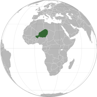
Niger or the Niger, officially the Republic of the Niger, is a country in West Africa. It is a unitary state bordered by Libya to the northeast, Chad to the east, Nigeria to the south, Benin and Burkina Faso to the southwest, Mali to the west, and Algeria to the northwest. It covers a land area of almost 1,270,000 km2 (490,000 sq mi), making it the largest landlocked country in West Africa and the second largest landlocked nation in Africa behind Chad. Over 80% of its land area lies in the Sahara. Its predominantly Muslim population of about 25 million lives mostly in clusters in the south and west of the country. The capital Niamey is located in Niger's southwest corner.

The music of Niger has developed from the musical traditions of a mix of ethnic groups; Hausa, the Zarma-Songhai, Tuareg, Fula, Kanuri, Toubou, Diffa Arabs and Gurma and the Boudouma from Lac Chad.

The culture of Niger is marked by variation, evidence of the cultural crossroads which French colonialism formed into a unified state from the beginning of the 20th century. What is now Niger was created from four distinct cultural areas in the pre-colonial era: the Djerma dominated Niger River valley in the southwest; the northern periphery of Hausaland, made mostly of those states which had resisted the Sokoto Caliphate, and ranged along the long southern border with Nigeria; the Lake Chad basin and Kaouar in the far east, populated by Kanuri farmers and Toubou pastoralists who had once been part of the Kanem-Bornu Empire; and the Tuareg nomads of the Aïr Mountains and Saharan desert in the vast north. Each of these communities, along with smaller ethnic groups like the pastoral Wodaabe Fula, brought their own cultural traditions to the new state of Niger.

The Songhai people are an ethnolinguistic group in West Africa who speak the various Songhai languages. Their history and lingua franca is linked to the Songhai Empire which dominated the western Sahel in the 15th and 16th century. Predominantly adherents of Islam, the Songhai are primarily located in Niger and Mali. Historically, the term "Songhai" did not denote an ethnic or linguistic identity but referred to the ruling caste of the Songhay Empire known as the Songhaiborai. However, the correct term used to refer to this group of people collectively by the natives is "Ayneha". Although some speakers in Mali have also adopted the name Songhay as an ethnic designation, other Songhay-speaking groups identify themselves by other ethnic terms such as Zarma or Isawaghen. The dialect of Koyraboro Senni spoken in Gao is unintelligible to speakers of the Zarma dialect of Niger, according to at least one report. The Songhay languages are commonly taken to be Nilo-Saharan but this classification remains controversial: Dimmendaal (2008) believes that for now it is best considered an independent language family.

Sudano-Sahelian architecture refers to a range of similar indigenous architectural styles common to the African peoples of the Sahel and Sudanian grassland (geographical) regions of West Africa, south of the Sahara, but north of the fertile forest regions of the coast.

Azawad, or Azawagh, was a short-lived unrecognised state lasting between 2012 and 2013. Azawagh (Azawaɣ) is the generic Tuareg Berber name for all Tuareg Berber areas, especially the northern half of Mali and northern and western Niger. The Azawadi declaration of independence was declared unilaterally by the National Movement for the Liberation of Azawad (MNLA) in 2012, after a Tuareg rebellion drove the Malian Armed Forces from the region.

From 1990 to 1995, a rebellion by various Tuareg groups took place in Niger and Mali, with the aim of achieving autonomy or forming their own nation-state. The insurgency occurred in a period following the regional famine of the 1980s and subsequent refugee crisis, and a time of generalised political repression and crisis in both nations. The conflict is one in a series of Tuareg-based insurgencies in the colonial and post-colonial history of these nations. In Niger, it is also referred to as the Second or Third Tuareg Rebellion, a reference to the pre-independence rebellions of Ag Mohammed Wau Teguidda Kaocen of the Aïr Mountains in 1914 and the rising of Firhoun of Ikazkazan in 1911, who reappeared in Mali in 1916. In fact the nomadic Tuareg confederations have come into sporadic conflict with the sedentary communities of the region ever since they migrated from the Maghreb into the Sahel region between the 7th and 14th centuries CE. Some Tuareg wanted an independent Tuareg nation to be formed when French colonialism ended. This, combined with dissatisfaction over the new governments, led some Tuareg in Northern Mali to rebel in 1963.
Arab Islamic Front of Azawad was a militant rebel group in northern Mali. It was headed by Ahmed Ould Sidi Mohamed.

Abalak is a town located in the Tahoua Region, Abalak Department of northern Niger. It is both a town and Commune: a local administrative division. It is the seat (Chef-lieu) of Abalak Department, one of eight subdivisions of Tahoua Region. The town had a population of less than 74,719 at the 2012 census.
Assamakka is a small desert town in northern Niger at a main border crossing with Algeria. It is the only official crossing point between the two nations. Assamakka shares the border with the larger town of In Guezzam 10 km on the Algerian side. A main road extends north in Algeria to Tamanrasset, 400 km away. Assamakka is connected to the town of Arlit, 200 km to the south by a road which remains in largely a sand "Piste". From Arlit, the "Uranium Highway", a tarred road built in the 1970s for mining trucks, travels south to Agadez and Niamey.

The Zarma people are an ethnic group predominantly found in westernmost Niger. They are also found in significant numbers in the adjacent areas of Nigeria and Benin, along with smaller numbers in Burkina Faso, Ivory Coast, Ghana, Togo, and Sudan. In Niger, the Zarma are often considered by outsiders to be of the same ethnicity as the neighboring Songhaiborai, although the two groups claim differences, having different histories and speaking different dialects. They are sometimes lumped together as the Zarma-Songhay or Songhay-Zarma.
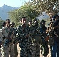
The Nigerien's Movement for Justice is a largely ethnic Tuareg militant group based in northern Niger. However the group also includes other nomadic ethnicities within this area, such as the Toubou and the Fulani. These groups have been battling the Niger government since 2007.
The following outline is provided as an overview of and topical guide to Niger:
Diffa Arabs is the Nigerien name given to a number of Arab nomadic tribes people living in eastern Niger, mostly in the Diffa Region.
Andéramboukane is a town and cercle in Ménaka Region, Mali. It lies at the extreme east of the country, several kilometers north of the Nigerien border. It was previously a commune in Ménaka Cercle but was promoted to the status of a cercle when Ménaka Region was implemented in 2016.
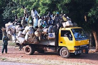
Seasonal migration, locally called the Exode, plays an important part of the economic and cultural life of the West African nation of Niger. While it is a common practice in many nations, Niger sees as much as a third of its rural population travel for seasonal labour, during the Sahelian nation's long dry season. Common patterns of seasonal travel have been built up over hundreds of years, and destinations and work vary by community and ethnic group.

Tassara is a village and rural commune in Niger.
The Dawsahak people, Idaksahak are pastoralist Berbers centered on Ménaka and Inékar town in Ménaka Region and Talataye in Ansongo Cercle of the Gao Region of northeastern Mali. They speak the Northern Songhai language Tadaksahak. Many also speak Western Tawallammat Tamajaq language, the Tuareg language of southern Gao. Daoussahak appears to be the most common transliteration of the collective name among French and English academics.
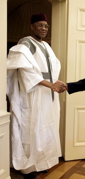
The boubou or grand boubou is a flowing wide-sleeved robe worn across West Africa, and to a lesser extent in North Africa, related to the dashiki suit.
The Azawagh Arabs are nomadic ethnic Arab-ancestry tribes who are settling mainly in the area of Azawagh which is a dry basin covering what is today northwestern Niger, as well as parts of northeastern Mali and southern Algeria.


