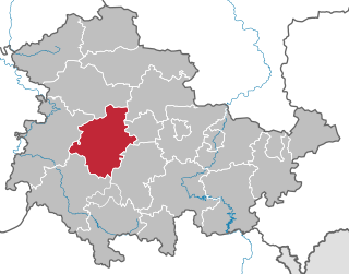
Gotha is a Kreis (district) in western central Thuringia, Germany. Neighboring districts are Unstrut-Hainich-Kreis, Sömmerda, the Kreis-free city Erfurt, Ilm-Kreis, Schmalkalden-Meiningen and the Wartburgkreis.

Schmalkalden-Meiningen is a Landkreis in the southwest of Thuringia, Germany. Its neighboring districts are the districts Wartburgkreis, Gotha, Ilm-Kreis, the district-free city Suhl, the district Hildburghausen, the Bavarian district Rhön-Grabfeld, and the district Fulda in Hesse.
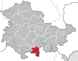
Sonneberg is a Kreis (district) in the south of Thuringia, Germany. Neighboring districts are the districts Hildburghausen, Saalfeld-Rudolstadt, and the Bavarian districts Kronach and Coburg.
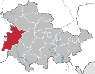
Wartburgkreis is a Kreis (district) in the west of Thuringia, Germany. Neighboring districts are the districts Unstrut-Hainich-Kreis, Gotha, Schmalkalden-Meiningen, and the districts Fulda, Hersfeld-Rotenburg and Werra-Meißner-Kreis in Hesse.

Hildburghausen is a town in Thuringia in central Germany, capital of the district Hildburghausen.
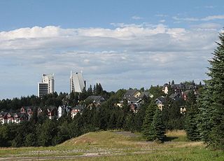
Oberhof is a town in the Schmalkalden-Meiningen district of Thuringia, Germany. Located in the Thuringian Forest mountain range, it is a winter sports center and health resort. With 1,625 inhabitants, it is visited by 144,000 tourists every year (2016). The town obtained its official city status in 1985.

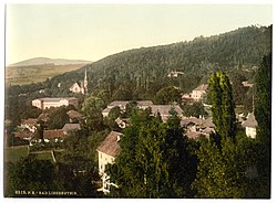
Schloss Altenstein is a schloss, or palace, upon a rocky hill on the south-western slope of the Thuringian Forest, not far from Eisenach, Thuringia, Germany. It was the summer residence of the Dukes of Saxe-Meiningen, and is surrounded by 160 hectares of English landscape garden, which contain, among other objects of interest, a cavern 300 metres long, through which flows a large and rapid stream.

Bad Berka is a German city, situated in the south of Weimar region in the state of Thuringia. With its almost 8,000 inhabitants Bad Berka is the second biggest city in Weimarer Land district. The river flowing through the city, which is embedded in new red sandstone, is called Ilm. Since 1 December 2008, the city has incorporated the former municipality of Gutendorf.

Bad Salzungen is a town in Thuringia, Germany. It is the capital of the Wartburgkreis district.

Bad Sulza is a town in the Weimarer Land district, in Thuringia, Germany. It is situated on the river Ilm, 15 km southwest of Naumburg, and 18 km north of Jena. The former municipality Ködderitzsch was merged into Bad Sulza in January 2019, and Saaleplatte in December 2019.

KaltennordheimGerman: [ˌkaltn̩ˈnɔʁt.haɪ̯m](listen) is a town in the Schmalkalden-Meiningen district, in Thuringia, Germany. It is situated in the Rhön Mountains, 22 km southwest of Bad Salzungen, and 35 km east of Fulda. The former municipalities Aschenhausen, Kaltensundheim, Kaltenwestheim, Melpers, Oberkatz und Unterweid were merged into Kaltennordheim in January 2019. At the same time, Kaltennordheim passed from the Wartburgkreis to Schmalkalden-Meiningen.

Vacha is a town in the Wartburgkreis district, in Thuringia, Germany. It is situated on the river Werra, 15 km west of Bad Salzungen, and 23 km east of Bad Hersfeld.

Hohenfelden is a municipality in the Weimarer Land district of Thuringia, Germany.
Seebach is a municipality in the Wartburgkreis district of Thuringia, Germany.

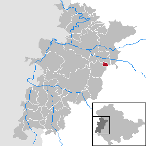
Elleben is a municipality in the district Ilm-Kreis, in Thuringia, Germany. Elleben has two named communities, Riechheim and Gügleben.
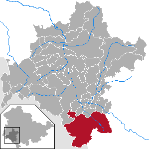
Grabfeld is a municipality in the district Schmalkalden-Meiningen, in Thuringia, Germany.

Dornburg-Camburg is a town in the Saale-Holzland district, in Thuringia, Germany. It was created on 1 December 2008, when the towns Dornburg and Camburg and the municipality Dorndorf-Steudnitz were merged.
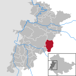
Wartburgkreis I is an electoral constituency represented in the Landtag of Thuringia. It elects one member via first-past-the-post voting. Under the current constituency numbering system, it is designated as constituency 5. It covers the southern part of Wartburgkreis and a small area of Schmalkalden-Meiningen.
Wartburgkreis III is an electoral constituency represented in the Landtag of Thuringia. It elects one member via first-past-the-post voting. Under the current constituency numbering system, it is designated as constituency 7. It covers the northern part of Wartburgkreis.