Gerstungen

Last updated
Gerstungen
Location of Gerstungen within Wartburgkreis district
Gerstungen in WAK.pngLauterbachLeimbachSeebachVacha
Germany adm location map.svg
Red pog.svg
Gerstungen
Thuringia location map.svg
Red pog.svg
Gerstungen
Coordinates: 50°57′45″N10°3′35″E / 50.96250°N 10.05972°E / 50.96250; 10.05972 Coordinates: 50°57′45″N10°3′35″E / 50.96250°N 10.05972°E / 50.96250; 10.05972
Country Germany
State Thuringia
District Wartburgkreis
Government
   Mayor (202228) Tim Rommert [1]
Area
  Total149.98 km2 (57.91 sq mi)
Elevation
205 m (673 ft)
Population
 (2020-12-31) [2]
  Total9,034
  Density60/km2 (160/sq mi)
Time zone UTC+01:00 (CET)
  Summer (DST) UTC+02:00 (CEST)
Postal codes
99834
Dialling codes 036922
Vehicle registration WAK
Website www.gerstungen.de

Gerstungen is a municipality in the Wartburgkreis district of Thuringia, Germany. In July 2018 the former municipalities of Marksuhl and Wolfsburg-Unkeroda were merged into Gerstungen.

History

A new border crossing for pedestrians across the Inner German border linking Lauchroden in Gerstungen municipality, and Herleshausen. This temporary bridge was built immediately after the reopening of the border at the site of an old bridge across the Werra which was destroyed in the Second World War. Here, visitors are queueing to enter East Germany on 23 December 1989. Bundesarchiv Bild 183-1989-1223-009, Erfurt, Grenzubergang Lauchroden - Herleshausen.jpg
A new border crossing for pedestrians across the Inner German border linking Lauchröden in Gerstungen municipality, and Herleshausen. This temporary bridge was built immediately after the reopening of the border at the site of an old bridge across the Werra which was destroyed in the Second World War. Here, visitors are queueing to enter East Germany on 23 December 1989.

Between 1945 and 1990, Gerstungen station served as East German inner German border crossing on the Thuringian Railway. The crossing was open for trains travelling between the Soviet Zone of occupation in Germany (till 1949, thereafter the East German Democratic Republic, or West Berlin and the American zone of occupation (till 1949) and thereafter the West German Federal Republic of Germany. The traffic was subject to the Interzonal traffic regulations, that between West Germany and West Berlin followed the special regulations of the Transit Agreement (1972).

Market place WAK GERSTUNGEN BRUNNEN.jpg
Market place

Related Research Articles

<span class="mw-page-title-main">Lauenburg</span> Town in Schleswig-Holstein, Germany

Lauenburg, or Lauenburg an der Elbe, is a town in the state of Schleswig-Holstein, Germany. It is situated on the northern bank of the river Elbe, east of Hamburg. It is the southernmost town of Schleswig-Holstein and belongs to the Kreis (district) of Herzogtum Lauenburg.

<span class="mw-page-title-main">Wingerode</span> Municipality in Thuringia, Germany

Wingerode is a municipality in the district of Eichsfeld in Thuringia, Germany. In 1996, Wingerode celebrated its 850th anniversary. It was founded in 1146.

Oebisfelde is a town and a former municipality in the Börde district in Saxony-Anhalt, Germany. Since 1 January 2010, it is part of the town Oebisfelde-Weferlingen. It is accessed by Bundesstraße 188.

<span class="mw-page-title-main">Heiligensee</span> Quarter of Berlin in Germany

Heiligensee is a locality within Reinickendorf, a borough of the German capital, Berlin.

<span class="mw-page-title-main">Schnackenburg</span> Town in Lower Saxony, Germany

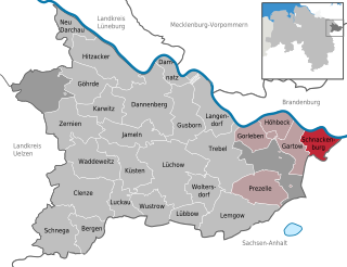
Schnackenburg is a town in the Lüchow-Dannenberg district, in Lower Saxony, Germany. It is situated on the left bank of the Elbe. It is part of the Samtgemeinde Gartow. Lying at the easternmost projection of Lower Saxony, the town is bordered on all sides except the west by territory that was formerly East Germany. It is the least densely populated town ("Stadt") in what was West Germany, although there are nine towns in what was formerly East Germany that are less densely populated.

<span class="mw-page-title-main">Büchen</span> Municipality in Schleswig-Holstein, Germany

Büchen is a municipality in the district of Lauenburg, in Schleswig-Holstein, Germany. It is seat of the Amt Büchen.

<span class="mw-page-title-main">Berlin border crossings</span> Post-WWII crossings in divided Berlin, Germany

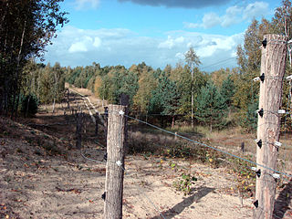
The Berlin border crossings were border crossings created as a result of the post-World War II division of Germany. Prior to the construction of the Berlin Wall in 1961, travel between the Eastern and Western sectors of Berlin was completely uncontrolled, although restrictions were increasingly introduced by the Soviet and East German authorities at major crossings between the sectors. This free access, especially after the closure of the Inner German border, allowed the Eastern Bloc emigration and defection to occur. East German officials, humiliated by this mass defection, subsequently chose to erect the Berlin Wall in order to prevent residents from leaving East Germany.

<span class="mw-page-title-main">Bad Salzungen</span> Town in Thuringia, Germany

Bad Salzungen is a town in Thuringia, Germany. It is the capital of the Wartburgkreis district.

<span class="mw-page-title-main">Zarrentin am Schaalsee</span> Town in Mecklenburg-Vorpommern, Germany

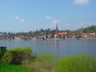
Zarrentin am Schaalsee, until 2004 simply Zarrentin, is a town in the Ludwigslust-Parchim district, in Mecklenburg-Western Pomerania, Germany. It is situated on the Schaalsee lake, 19 km southeast of Ratzeburg, and 34 km west of Schwerin.

<span class="mw-page-title-main">Berg, Upper Franconia</span> Municipality in Bavaria, Germany

Berg is a municipality in the district of Hof in Bavaria, Germany.

<span class="mw-page-title-main">Töpen</span> Municipality in Bavaria, Germany

Töpen is a municipality in Upper Franconia in the district of Hof in Bavaria in Germany.

<span class="mw-page-title-main">Dallgow-Döberitz</span> Municipality in Brandenburg, Germany

Dallgow-Döberitz is a municipality in the Havelland district, in Brandenburg, Germany.

<span class="mw-page-title-main">Cumlosen</span> Municipality in Brandenburg, Germany

Cumlosen is a municipality in the Prignitz district, in Brandenburg, Germany.

<span class="mw-page-title-main">Rühen</span> Municipality in Lower Saxony, Germany

Rühen is a municipality in the district of Gifhorn, in Lower Saxony, Germany. The Municipality Rühen includes the villages of Brechtorf, Eischott and Rühen.

<span class="mw-page-title-main">Wildeck</span> Municipality in Hesse, Germany

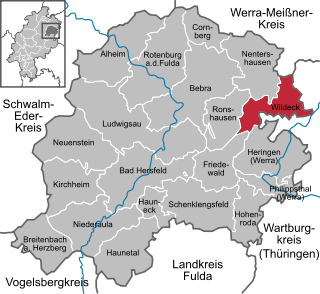
Wildeck is a community in Hersfeld-Rotenburg district in northeastern Hesse, Germany lying right at the boundary with Thuringia, 54 km southeast of Kassel.

<span class="mw-page-title-main">Nostorf</span> Municipality in Mecklenburg-Vorpommern, Germany

Nostorf is a municipality in the Ludwigslust-Parchim district, in Mecklenburg-Vorpommern, Germany.

<span class="mw-page-title-main">Schwanheide</span> Municipality in Mecklenburg-Vorpommern, Germany

Schwanheide is a municipality in the Ludwigslust-Parchim district, in Mecklenburg-Vorpommern, Germany.

<span class="mw-page-title-main">Gudow</span> Municipality in Schleswig-Holstein, Germany

Gudow is a municipality in the district of Lauenburg, in Schleswig-Holstein, Germany.

<span class="mw-page-title-main">Probstzella</span> Municipality in Thuringia, Germany

Probstzella is a municipality in the district Saalfeld-Rudolstadt, in Thuringia, Germany.

The Halle–Bebra railway, known in German as the Thüringer Bahn, is a 210 kilometre-long railway line from Halle (Saale) via Erfurt and Gerstungen to Bebra, mainly in Thuringia. As far as Gerstungen the line originally belonged to the Thuringian Railway Company. From Gerstungen to Bebra, it was owned by the Frederick William Northern Railway (Friedrich-Wilhelms-Nordbahn), named after the Prussian king, Frederick William IV. It is now a two-track, electrified, standard gauge mainline operated by DB Netze. It was opened between 1846 and 1849 and was the first railway line in Thuringia. All types of trains from Regionalbahn to ICE currently run on the line except Interregio-Express. Four of the six largest cities in Thuringia are located on the line.

References

  1. Gewählte Bürgermeister - aktuelle Landesübersicht, Freistaat Thüringen, accessed 10 November 2022.
  2. "Bevölkerung der Gemeinden, erfüllenden Gemeinden und Verwaltungsgemeinschaften in Thüringen Gebietsstand: 31.12.2020". Thüringer Landesamt für Statistik (in German). June 2021.