Bairiki

Last updated
Bairiki
Town
KiribatiPresidential Residence.jpg
State House in Bairiki
06 Map of South Tarawa, Kiribati.jpg
Location in South Tarawa
Kiribati location map.svg
Red pog.svg
Bairiki
Location in Kiribati
Coordinates: 01°19′32″N172°59′00″E / 1.32556°N 172.98333°E / 1.32556; 172.98333
CountryFlag of Kiribati.svg  Kiribati
Island group Gilbert Islands
Atoll Tarawa
Area
  Total0.460128 km2 (0.177656 sq mi)
Elevation
3 m (10 ft)
Population
 (2010)
  Total3,524
  Density7,700/km2 (20,000/sq mi)

The town of Bairiki, which is located in South Tarawa, Kiribati, is crucial to the country's political and administrative structure. This region houses important governmental organizations and diplomatic missions, making it the center of national politics and international affairs.

Contents

The State House, an iconic building that serves as the official residence of Kiribati's head of state, is located in the center of Bairiki. It serves as both a historical and diplomatic landmark and a representation of the country's governance. The National Stadium, a location of utmost significance for holding numerous sporting events and national meetings that unite communities, is also located in Bairiki.

Overview

The prestigious High Commissions of Australia and New Zealand, as well as the renowned embassy of China, are just a few of Bairiki's many international connections. These diplomatic missions make a vital contribution to the partnerships and relationships between Kiribati and these countries, encouraging bilateral cooperation on a range of issues, from economic to cultural exchange.

Bairiki is the hub of Kiribati's government system in addition to playing a diplomatic function. The majority of the important Government Ministries have their headquarters in this community, highlighting its crucial significance in the regular operation of the country's administrative machinery. Its reputation as the administrative hub of Kiribati is furthered by the concentration of ministries in Bairiki.

The Teinainano Urban Council (TUC), which is in charge of managing many facets of local government and community development, has administrative control over Bairiki. The TUC is essential in preserving Bairiki's infrastructure and public services, assuring the welfare and prosperity of its residents.

A total of 3,524 people called Bairiki home as of the 2010 Census. The dynamic and diversified community that flourishes within this settlement is revealed by this demographic snapshot, adding to Bairiki's cultural diversity and social fabric.

Geography

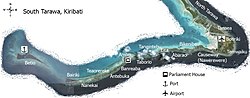
Bairiki is an islet near the Western end of South Tarawa. It is joined to Betio by the Nippon Causeway, which opened in 1989, and is also joined to Naanekai by a causeway, forming part of a continuous road which links South Tarawa from Betio in the West to Bonriki International Airport in the East.

Bairiki is a small islet, with a land area of less than half a square km. [1] Much of the land is occupied by the Government itself, including the Bairiki National Stadium and the main offices of many of the Government ministries, and by foreign High Commissions with their associated residences. The village community of Bairiki lives in very crowded conditions, and rapid population growth is causing significant problems.

Education

King George V School, a secondary school for boys, opened in Bairiki in 1922. It later moved to Abemama. [2]

Transport

The city has road connections to Betio and Nanikai

Census1978 [3] 2005 [4] 2010 [5]
Bairiki1,9562,7663,524

See also

Related Research Articles

<span class="mw-page-title-main">Kiribati</span> Country in the central Pacific Ocean

Kiribati, officially the Republic of Kiribati, is an island country in the Micronesia subregion of Oceania in the central Pacific Ocean. Its permanent population is over 119,000 as of the 2020 census, with more than half living on Tarawa atoll. The state comprises 32 atolls and one remote raised coral island, Banaba. Its total land area is 811 km2 (313 sq mi) dispersed over 3,441,810 km2 (1,328,890 sq mi) of ocean.

<span class="mw-page-title-main">Gilbert and Ellice Islands</span> 1892–1976 British colony in the Pacific

The Gilbert and Ellice Islands in the Pacific Ocean were part of the British Empire from 1892 to 1976. They were a protectorate from 1892 to 12 January 1916, and then a colony until 1 January 1976. The history of the colony was mainly characterized by phosphate mining on Ocean Island. In October 1975, these islands were divided by force of law into two separate colonies, and they became independent nations shortly thereafter: the Ellice Islands became Tuvalu in 1978, and the Gilbert Islands became part of Kiribati in 1979.

<span class="mw-page-title-main">Abaiang</span> Atoll of Kiribati

Abaiang, also known as Apaiang, Apia, and in the past, Charlotte Island, in the Northern Gilbert Islands, is a coral atoll of Kiribati, located in the west-central Pacific Ocean. Abaiang was the island of the first missionary to arrive in the Gilberts, Hiram Bingham II. Abaiang has a population of 5,872.

<span class="mw-page-title-main">Butaritari</span> Atoll in the Pacific Ocean island nation of Kiribati

Butaritari is an atoll in the Pacific Ocean island nation of Kiribati. The atoll is roughly four-sided. The south and southeast portion of the atoll comprises a nearly continuous islet. The atoll reef is continuous but almost without islets along the north side. Bikati and Bikatieta islets occupy a corner of the reef at the extreme northwest tip of the atoll. Small islets are found on reef sections between channels on the west side. The lagoon of Butaritari is deep and can accommodate large ships, though the entrance passages are relatively narrow. It is the most fertile of the Gilbert Islands, with relatively good soils and high rainfall. Butaritari atoll has a land area of 13.49 km2 (5.21 sq mi) and a population of 3,224 as of 2015. During World War II, Butaritari was known by United States Armed Forces as Makin Atoll, and was the site of the Battle of Makin. Locally, Makin is the name of a separate but closest atoll, 3 kilometres to the northeast of Butaritari, but close enough to be seen. These two atolls share a dialect of the Gilbertese language.

<span class="mw-page-title-main">Tarawa</span> Atoll in the South Pacific

Tarawa is an atoll and the capital of the Republic of Kiribati, in the Micronesia region of the central Pacific Ocean. It comprises North Tarawa, which has 6,629 inhabitants and much in common with other more remote islands of the Gilberts group, and South Tarawa, which has 56,388 inhabitants as of 2015, half of the country's total population. The atoll was the site of the Battle of Tarawa during World War II.

<span class="mw-page-title-main">South Tarawa</span> Island of the Republic of Kiribati

South Tarawa is the capital and hub of the Republic of Kiribati and home to more than half of Kiribati's population. The South Tarawa population centre consists of all the small islets from Betio in the west to Bonriki and Tanaea in the north-east, connected by the South Tarawa main road, with a population of 63,439 as of 2020.

<span class="mw-page-title-main">Betio</span> Town in Gilbert Islands, Kiribati

Betio is the largest township of Kiribati's capital city, South Tarawa, and the country's main port. The settlement is located on a separate islet at the extreme southwest of the atoll.

<span class="mw-page-title-main">Abemama</span> Atoll of Kiribati

Abemama (Apamama) is an atoll, one of the Gilberts group in Kiribati, and is located 152 kilometres southeast of Tarawa and just north of the Equator. Abemama has an area of 27.37 square kilometres and a population of 3,299 as of 2015. The islets surround a deep lagoon. The eastern part of the atoll of Abemama is linked together by causeways making automobile traffic possible between the different islets. The outlying islands of Abatiku and Biike are situated on the southwestern side of the atoll.

<span class="mw-page-title-main">Kuria (atoll)</span> Atoll in Central Gilbert Islands, Kiribati

Kuria is an atoll, formed by a pair of islets, in the Central Gilbert Islands in Kiribati, northwest of Aranuka. The two islets, Buariki and Oneeke, are separated by a 20 metre wide channel on a shallow water platform, which is crossed by a bridge of the connecting road. The islands are surrounded by fringing reef which is broadest on the eastern side of Kuria. The population of Kuria was 1,046 in 2015.

<span class="mw-page-title-main">Nonouti</span>

Nonouti is an atoll and district of Kiribati. The atoll is located in the Southern Gilbert Islands, 38 km north of Tabiteuea, and 250 km south of Tarawa. The atoll is the third largest in the Gilbert Islands and is the island where the Roman Catholic religion was first established in Kiribati, in 1888.

<span class="mw-page-title-main">Law enforcement in Kiribati</span>

The only State disciplined forces in Kiribati are a unified national police force, with prison and quarantine powers, and the coast guard. Defense assistance is provided by Australia and New Zealand. The police force does not report to any ministers but rather directly to the President of Kiribati.

<span class="mw-page-title-main">Makin (atoll)</span>

Makin is the name of an atoll, chain of islands, located in the Pacific Ocean island nation of Kiribati. Makin is the northernmost of the Gilbert Islands, with a population of 1,990.

<span class="mw-page-title-main">Bikenibeu</span> Place in Gilbert Islands, Kiribati

Bikenibeu is a settlement in Kiribati. It is located close to the southeastern corner of the Tarawa atoll, part of the island country of Kiribati. It is part of a nearly continuous chain of settlements along the islands of South Tarawa, which are now linked by causeways. The low-lying atoll is vulnerable to sea level rise. Rapid population growth has caused some environmental problems. Kiribati's main government high school, King George V and Elaine Bernachi School, is located in Bikenibeu, as well as the Ministries of Environment and Education.

<span class="mw-page-title-main">Buariki (Tarawa)</span>

Buariki is an island in northern Tarawa Atoll in the Gilbert Islands of the Republic of Kiribati. It was the site of the Battle of Buariki in World War II.

<span class="mw-page-title-main">Religion in Kiribati</span> Religions in the country

Christianity is the predominant religion in Kiribati, with Catholicism being its largest denomination.

<span class="mw-page-title-main">Cabinet of Kiribati</span>

The Cabinet of Kiribati is the cabinet of the government of the Republic of Kiribati.

<span class="mw-page-title-main">North Tarawa</span> A string of islets in Kiribati governed by the Eutan Tarawa Council

North Tarawa or in Gilbertese Tarawa Ieta, in the Republic of Kiribati, is the string of islets from Buariki at the northern tip of Tarawa atoll to Buota in the South, with a combined population of 6,629 as of 2015. It is administratively separate from neighbouring South Tarawa, and is governed by the Eutan Tarawa Council (ETC), based at Abaokoro.

<span class="mw-page-title-main">Governor of the Gilbert and Ellice Islands</span>

The Governor of the Gilbert and Ellice Islands was the colonial head of the Gilbert and Ellice Islands civil service from 1892 until 1979.

<span class="mw-page-title-main">Teaoraereke</span>

Teaoraereke is a town and settlement in South Tarawa of Kiribati.

<span class="mw-page-title-main">Temwaiku</span>

Temwaiku is a town and settlement in South Tarawa in Kiribati. It is part of a nearly continuous chain of settlements along the islands of South Tarawa, which are linked by causeways, in the same islet of Bonriki.

References

  1. "Kiribati Census 2010 Volume 1" (PDF). Statistics Office, Ministry of Finance and Economic Development, Government of Kiribati. Archived from the original (PDF) on 2013-09-30.
  2. Talu, Alaima. "Towards Quality in Education" (Chapter 21, in Part IV: Social Issues). In: Van Trease, Howard (editor). Atoll Politics: The Republic of Kiribati. University of Canterbury MacMillan Brown Centre for Pacific Studies and University of the South Pacific, 1993. ISBN   095833000X, 9780958330008. p. 241
  3. Report of the 1978 Census of population and housing. Republic of Kiribati 1980, Vol. 1, S. 6–7
  4. Kiribati 2005 census of population and housing.
  5. "Kiribati Census Report 2010 Volume 1" (PDF). National Statistics Office, Ministry of Finance and Economic Development, Government of Kiribati. Archived from the original (PDF) on 30 September 2013. Retrieved 17 March 2013.