South Tarawa

Last updated

South Tarawa
South Tarawa from the air.jpg
Sacred Heart Cathedral (Tarawa).jpg
KiribatiParliamentHouse.jpg
Teaoraereke, South Tarawa, Kiribati.jpg
Bonriki International Airport.jpg
Top: Aerial view of South Tarawa; Middle: Sacred Heart Cathedral, Kiribati Parliament House; Tarawa coastline, Bonriki International Airport
GilbertIslandsPos.png
Kiribati location map.svg
Red pog.svg
South Tarawa
Location in Kiribati
Micronesia regions map.png
Red pog.svg
South Tarawa
South Tarawa (Micronesia)
Oceania laea location map.svg
Red pog.svg
South Tarawa
South Tarawa (Oceania)
Pacific Ocean laea location map.svg
Red pog.svg
South Tarawa
South Tarawa (Pacific Ocean)
Geography
LocationPacific Ocean
Coordinates 1°26′N173°0′E / 1.433°N 173.000°E / 1.433; 173.000
Archipelago Gilbert Islands
Area15.76 km2 (6.08 sq mi)
Highest elevation3 m (10 ft)
Administration
Kiribati
Demographics
Population63,439 [1] (2020 census)
Pop. density3,578/km2 (9267/sq mi)
Ethnic groups I-Kiribati 95.9%

South Tarawa (Gilbertese : Tarawa Teinainano) is the capital and hub of the Republic of Kiribati and home to more than half of Kiribati's population. [2] The South Tarawa population centre consists of all the small islets from Betio in the west to Bonriki and Tanaea in the north-east, connected by the South Tarawa main road, with a population of 63,439 as of 2020. [1]

Contents

South Tarawa is home to most of the government, commercial and education facilities in Kiribati including the Port and the High Court at Betio, the State House, Government Ministries and foreign embassies and High Commissions in Bairiki, the University of the South Pacific campus in Teaoraereke, the House of Assembly in Ambo, the Kiribati Teacher College and King George V and Elaine Bernacchi School, the Government High School, is in Bikenibeu, [3] and the Tungaru central hospital in Nawerewere. The Roman Catholic Diocese is based in Teaoraereke, the Kiribati Uniting Church in Antebuka, the National Spiritual Assembly of the Bahá’ís of Kiribati in Bikenibeu, and the Church of Jesus Christ of Latter-day Saints in Eita. [4]

Administration

At the local government level, South Tarawa has two administrative subdivisions, created by John Hilary Smith in 1972:

Buota, which is part of North Tarawa and administered by the Eutan Tarawa Council (or ETC), is linked by road to South Tarawa and is experiencing many similar issues of rapid population growth, urbanisation and environmental degradation.

Flag of Teinainano Urban Council Flag of Teinainano Urban Council, Kiribati.svg
Flag of Teinainano Urban Council
Flag of Betio Town Council Flag of Betio Town Council.svg
Flag of Betio Town Council

Geography

Map of South Tarawa (orange) and North Tarawa (green) within Tarawa Atoll South Tarawa (separated to north and south).svg
Map of South Tarawa (orange) and North Tarawa (green) within Tarawa Atoll

South Tarawa is a string of islets on the atoll of Tarawa, between the Tarawa Lagoon to the north, with a maximum depth of 25 metres (82 ft), and the Pacific Ocean to the south, with a depth of up to 4,000 metres (13,000 ft). [5] The island has been built from sediments from the lagoon. [6]

The process of soil accumulation is driven by the dominant easterly trade winds and can be reversed during extended periods of westerly winds during El Niño–Southern Oscillations. [7]

These islets are now joined by causeways, forming one long islet on the reef along the southern side of the Tarawa Lagoon. Most of South Tarawa is less than 3 metres (9.8 feet) above sea level with an average width of only 450 metres (1,480 feet). [4]

Seaside at Teaoraereke, South Tarawa Teaoraereke, South Tarawa, Kiribati.jpg
Seaside at Teaoraereke, South Tarawa

Population

Children in Bairiki Square, South Tarawa Children in Bairiki Square, Tarawa, Kiribati.JPG
Children in Bairiki Square, South Tarawa

At the time of the 1978 Census, South Tarawa had a population of 17,921 with most residents living in the main population centres of Betio, Bairiki and Bikenibeu. Since Kiribati became independent in 1979, the population of South Tarawa has more than tripled, and now stands at 63,439 people (2020). [1] All of South Tarawa is now urbanised and is effectively one continuous settlement from the northeastern end of the island, Tanaea, to its southwestern end at Betio.

Buota in North Tarawa is connected to the South Tarawa main road and is also growing rapidly.

South Tarawa: Places and population
Census area1978 [8] 2005 [9] 2010 [1] 2015 [1]
Tanaea2791279198
Bonriki 6352,1192,3552,829
Temwaiku 2,0113,1354,072
Causeway (Nawerewere)1,7802,0541,843
Bikenibeu 3,9716,1706,5687,575
Abarao3229081,6651,761
Eita 6122,2993,0613,395
Tangintebu1289489150
Taborio1879551,2821,293
Ambo 1,6882,2002,780
Banraeaba5011,7891,9692,072
Antebuka5043901,0871,615
Teaoraereke 8483,9394,1715,105
Nanikai6048039881,152
Bairiki 1,9562,7663,5243,278
Betio 7,62612,50915,75517,330
South Tarawa total17,92140,31150,18256,388

History

Tarawa island is central to Kiribati mythology and culture, but life on South Tarawa was little different to that on other islands before it was selected in 1895 as the seat of colonial government for the Protectorate of the Gilbert and Ellice Islands. From 1906 to 1942, Ocean Island was the headquarters of the colony, then Funafuti because of the Japanese occupation of the Gilbert Islands until 1946, when it returned to Tarawa.

Betio was the location of the Battle of Tarawa.

Environment

Impacts of coastal erosion and drought on coconut palms in Eita, Tarawa, Kiribati.JPG
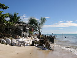
Impacts of coastal erosion and drought on coconut palms in Eita, South Tarawa
Household experiencing coastal erosion on South Tarawa.JPG
Households on South Tarawa do not have the option to retreat from coastal erosion, as the atoll is narrow and already crowded.

The highest point on South Tarawa is only a very few meters above sea level (Eita, 3 metres), making the island extremely vulnerable to natural disasters. The effects of floods and associated soil salination are starting to threaten limited freshwater supplies. [10]

Climate

The climate in South Tarawa is a Tropical rainforest climate (Koppen: Af) which is warm and humid all year round and average rainfalls are relatively high. However, rainfall is very unpredictable, varying with the El Niño–Southern Oscillation, and South Tarawa can go for many months with almost no rain during La Niña cycles. The hottest and coldest temperatures ever recorded in South Tarawa are 35 °C (95 °F) and 21 °C (70 °F), respectively, which is one of the narrowest temperature ranges in the world.

Climate data for Tarawa Airport (South Tarawa)
MonthJanFebMarAprMayJunJulAugSepOctNovDecYear
Record high °C (°F)35.0
(95.0)
33.0
(91.4)
35.0
(95.0)
34.5
(94.1)
34.5
(94.1)
33.5
(92.3)
34.5
(94.1)
34.5
(94.1)
34.5
(94.1)
35.0
(95.0)
35.0
(95.0)
35.0
(95.0)
35.0
(95.0)
Mean daily maximum °C (°F)30.7
(87.3)
30.6
(87.1)
30.7
(87.3)
30.7
(87.3)
30.8
(87.4)
30.8
(87.4)
30.9
(87.6)
31.0
(87.8)
31.1
(88.0)
31.2
(88.2)
31.3
(88.3)
30.9
(87.6)
30.9
(87.6)
Daily mean °C (°F)28.2
(82.8)
28.1
(82.6)
28.1
(82.6)
28.2
(82.8)
28.4
(83.1)
28.3
(82.9)
28.2
(82.8)
28.3
(82.9)
28.4
(83.1)
28.6
(83.5)
28.5
(83.3)
28.2
(82.8)
28.3
(82.9)
Mean daily minimum °C (°F)25.3
(77.5)
25.3
(77.5)
25.2
(77.4)
25.3
(77.5)
25.5
(77.9)
25.3
(77.5)
25.1
(77.2)
25.2
(77.4)
25.3
(77.5)
25.4
(77.7)
25.4
(77.7)
25.3
(77.5)
25.3
(77.5)
Record low °C (°F)21.5
(70.7)
22.5
(72.5)
22.5
(72.5)
22.5
(72.5)
21.0
(69.8)
21.0
(69.8)
21.0
(69.8)
21.5
(70.7)
22.5
(72.5)
22.0
(71.6)
22.5
(72.5)
22.0
(71.6)
21.0
(69.8)
Average precipitation mm (inches)271
(10.7)
218
(8.6)
204
(8.0)
184
(7.2)
158
(6.2)
155
(6.1)
168
(6.6)
138
(5.4)
120
(4.7)
110
(4.3)
115
(4.5)
212
(8.3)
2,052
(80.8)
Average precipitation days (≥ 0.3 mm)151214151514161815111017172
Average relative humidity (%)81808182818180797777798180
Mean monthly sunshine hours 220.1192.1207.7201.0229.4219.0229.4257.3243.0260.4240.0189.12,688.5
Mean daily sunshine hours 7.16.86.76.77.47.37.48.38.18.48.06.17.4
Source: Deutscher Wetterdienst [11]

Water

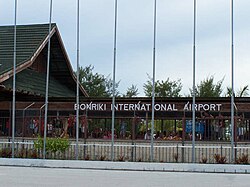
South Tarawa has very limited water resources for its rapidly growing population. During the frequent droughts, the only source of water is the shallow freshwater lens that permeates the coral rock of the atoll. The water lenses at Bonriki and Buota have been declared as water reserves, and have a combined sustainable yield of 1,300 m3 per day.

Other previously declared water reserves have been relinquished for urbanisation or abandoned due to overpumping and pollution from human settlement. [12]

Water from the Bonriki and Buota reserves is distributed by a reticulated network to South Tarawa households. However, the poor condition of the network and the limited water supply mean that water can only be supplied to each village for around 2 hours every two days. Most schools and community buildings have no water supply at all, and many households rely on polluted groundwater due to the shortage of treated water. [13]

Because of the shortage of fresh water, sanitation systems must use saltwater for flushing. The sanitation network on South Tarawa is performing very poorly, and a major project is underway to rehabilitate the system and improve sanitation and public hygiene. [14]

Coastal erosion

The Ministry of Environment, Lands and Agricultural Development (MELAD) is involved in the replanting of mangroves in selected sites to help against coastal erosion; however, much more is required to protect many of the sites eroded on South Tarawa including islets that once were protected with mangrove and iron-wood (tengea) trees. It is unclear how much of the erosion being experienced on South Tarawa is due to sea-level rise and how much is due to human activities (such as building inappropriate seawalls and mining sand and gravel from the beaches and foreshores). Coastal erosion will accelerate in future, due to climate change related sea level rise. [4]

Land availability and overcrowding

Tarawa Tarawa, Kiribati.jpg
Tarawa

The land area of South Tarawa is officially recorded as 3,896 acres (1,577 ha) or 15.76 square km.

Much of this land is not available for use, including the water reserve and runway, the causeways, and a large area of reclaimed land at Temwaiku, the eastern corner of the atoll, which is too swampy and low-lying. If these areas are excluded, the land area of South Tarawa is only just over 1,000 hectares (10 square km or 2,500 acres) and the population density of 49 people per hectare or 4,905 per square km is almost equal to the density of London (5,100 people per km2) and twice the density of Sydney or Auckland. [15]

Multi-story buildings are very uncommon on South Tarawa. The high population is accommodated through large household sizes, with an average of 7.3 people per household, on small land plots. Most land is owned by the original families or kain Tarawa, although in the main centres of Betio, Bairiki and Bikenibeu there are large areas of land on long-term lease to the government. Without access to family lands or government housing, many South Tarawa residents have no choice but to become squatters; disputes over land are common.

South Tarawa and especially Betio have high rates of respiratory infections, diarrhoea, and dysentery, [4] all of which have been linked to overcrowding. [16] Unsustainable development in South Tarawa is a concern to the government and to Kiribati's aid partners. [17] Anote Tong's administration aims to ease the problem in the country's main urban centre by encouraging people to stay and to resettle in outer islands. It has invested in facilities such as the South Kiribati Hospital to spread institutions and services out around the islands and relieve South Tarawa from overcrowding. [18]

South Tarawa: Population and Land Area
Census AreaPopulation 2010 [1] Land area available [1] Land area, not available for residential, commercial or government use [1] Density, people per hectare
Tanaea2799 hectares (22 acres)31
Bonriki235570 hectares (173 acres)139 hectares (343 acres)134
Temwaiku3135161 hectares (398 acres)383 hectares (946 acres)219
Causeway/Nawerewere2054
Bikenibeu6568181 hectares (447 acres)36
Abarao166558 hectares (143 acres)29
Eita3061104 hectares (257 acres)9 hectares (22 acres)329
Tangintebu89
Taborio1282
Ambo2200141 hectares (348 acres)16
Banraeaba1969
Antebuka1087
Teaoraereke417187 hectares (215 acres)4.2 hectares (10 acres)448
Nanikai98812 hectares (30 acres)82
Bairiki352446 hectares (114 acres)5.0 hectares (12 acres)577
Betio-Bairiki causewaynot included
Betio15755154 hectares (381 acres)13.7 hectares (34 acres)6102
South Tarawa total501821,023 hectares (2,528 acres)553 hectares (1,366 acres)49
Reasons land not available for use:
  1. Bonriki; Water reserve, airport
  2. Temwaiku; Reclamation and fish ponds
  3. Eita/Taborio; Abairarang (scout) Is. Abaokoro (Guide) Is. and Taborio Causeway
  4. Teaoraereke; Causeway
  5. Naanekai-Bairiki causeway, Bairiki wharf and jetty
  6. Betio; Sandspit, wharves, jetties

Economy

Fishing for family consumption and for sale is essential to the economy of South Tarawa Fishing for family consumption and for sale is essential to the economy.jpg
Fishing for family consumption and for sale is essential to the economy of South Tarawa

South Tarawa is the economic hub of Kiribati, the location of the main port and airport and of most of the state-owned enterprises and private businesses.

Loading copra at Betio port, South Tarawa Loading copra at Betio port, Kiribati.JPG
Loading copra at Betio port, South Tarawa

Copra produced on the outer islands is processed on Betio, producing copra oil for the international market and other products which are sold locally. There is a fish processing plant producing tuna for export.

Imports far outweigh exports, and most households on South Tarawa rely on government employment and remittances from relatives working overseas. Unemployment and underemployment are a serious problem; in 2010 only 34% of urban adults (over 15) were engaged in cash work; the remaining two-thirds are either out of the labour force, unemployed or engaged in subsistence activities. Young people are especially likely to be unemployed.

Education

Currently there is one government high school, King George V and Elaine Bernacchi School in Bikenibeu. There are also several private Christian high schools: [19]

Visiting

Bonriki International Airport Bonriki International Airport.jpg
Bonriki International Airport

Transport

Fiji Airways flies to Bonriki International Airport on South Tarawa from Nadi, on Mondays and Thursdays. Solomon Airlines flies to Honiara and Brisbane at least once a week.

Accommodation

There is a range of accommodation available for visitors and for those working short term in South Tarawa. [20]

See also

Related Research Articles

<span class="mw-page-title-main">Kiribati</span> Country in the central Pacific Ocean

Kiribati, officially the Republic of Kiribati, is an island country in the Micronesia subregion of Oceania in the central Pacific Ocean. Its permanent population is over 119,000 as of the 2020 census, with more than half living on Tarawa atoll. The state comprises 32 atolls and one remote raised coral island, Banaba. Its total land area is 811 km2 (313 sq mi) dispersed over 3,441,810 km2 (1,328,890 sq mi) of ocean.

<span class="mw-page-title-main">Abaiang</span> Atoll of Kiribati

Abaiang, also known as Apaiang, Apia, and in the past, Charlotte Island, in the Northern Gilbert Islands, is a coral atoll of Kiribati, located in the west-central Pacific Ocean. Abaiang was the island of the first missionary to arrive in the Gilberts, Hiram Bingham II. Abaiang has a population of 5,872.

<span class="mw-page-title-main">Tabiteuea</span> Atoll in the Gilbert Islands, Kiribati

Tabiteuea is an atoll in the Gilbert Islands, Kiribati, farther south of Tarawa. This atoll is the second largest and the most populated of the Gilbert Islands after Tarawa. The atoll consists of one main island, Aanikai in the north, and several smaller islets in between along the eastern rim of the atoll. The atoll has a total land area of 38 km2 (15 sq mi), while the lagoon measures 365 km2 (141 sq mi). The population numbered 5,261 in 2015. The islanders have customary fishing practices related to the lagoon and the open ocean.

<span class="mw-page-title-main">Tarawa</span> Atoll in the South Pacific

Tarawa is an atoll and the capital of the Republic of Kiribati, in the Micronesia region of the central Pacific Ocean. It comprises North Tarawa, which has 6,629 inhabitants and much in common with other more remote islands of the Gilberts group, and South Tarawa, which has 56,388 inhabitants as of 2015, half of the country's total population. The atoll was the site of the Battle of Tarawa during World War II.

<span class="mw-page-title-main">Bairiki</span> Town in Gilbert Islands, Kiribati

The important town of Bairiki, which is located in South Tarawa, Kiribati, is crucial to the country's political and administrative structure. This region houses important governmental organizations and diplomatic missions, making it the center of national politics and international affairs.

<span class="mw-page-title-main">Betio</span> Town in Gilbert Islands, Kiribati

Betio is the largest township of Kiribati's capital city, South Tarawa, and the country's main port. The settlement is located on a separate islet at the extreme southwest of the atoll.

<span class="mw-page-title-main">Abemama</span> Atoll of Kiribati

Abemama (Apamama) is an atoll, one of the Gilberts group in Kiribati, and is located 152 kilometres southeast of Tarawa and just north of the Equator. Abemama has an area of 27.37 square kilometres and a population of 3,299 as of 2015. The islets surround a deep lagoon. The eastern part of the atoll of Abemama is linked together by causeways making automobile traffic possible between the different islets. The outlying islands of Abatiku and Biike are situated on the southwestern side of the atoll.

<span class="mw-page-title-main">Bonriki International Airport</span> Airport in Bonriki, South Tarawa

Bonriki International Airport is an international airport in Kiribati, serving as the main gateway to the country. It is located in its capital, South Tarawa, which is a group of islets in the atoll of Tarawa in the Gilbert Islands, precisely on Bonriki.

<span class="mw-page-title-main">Bikeman Island</span>

Bikeman Island is a submerged islet about a half-hour's canoe ride northeast of Betio, Kiribati. Due to changing currents and the construction of a causeway between Betio and Bairiki, Bikeman has been submerged since the early 1990s. If one were to stand on Bikeman today, the water would reach up to one's knees.

<span class="mw-page-title-main">Law enforcement in Kiribati</span>

The only State disciplined forces in Kiribati are a unified national police force, with prison and quarantine powers, and the coast guard. Defense assistance is provided by Australia and New Zealand. The police force does not report to any ministers but rather directly to the President of Kiribati.

<span class="mw-page-title-main">Makin (atoll)</span>

Makin is the name of an atoll, chain of islands, located in the Pacific Ocean island nation of Kiribati. Makin is the northernmost of the Gilbert Islands, with a population of 1,990.

<span class="mw-page-title-main">Bikenibeu</span> Place in Gilbert Islands, Kiribati

Bikenibeu is a settlement in Kiribati. It is located close to the southeastern corner of the Tarawa atoll, part of the island country of Kiribati. It is part of a nearly continuous chain of settlements along the islands of South Tarawa, which are now linked by causeways. The low-lying atoll is vulnerable to sea level rise. Rapid population growth has caused some environmental problems. Kiribati's main government high school, King George V and Elaine Bernachi School, is located in Bikenibeu, as well as the Ministries of Environment and Education.

<span class="mw-page-title-main">Bonriki</span>

Bonriki is a settlement on Tarawa atoll, Kiribati, near Temwaiku and is part of the municipality of South Tarawa. It is in the south-east of South Tarawa. Bonriki International Airport, one of two international airports in Kiribati, is located here. One of the first roads linking islands together in Tarawa connects Bonriki to Bikenibeu.

<span class="mw-page-title-main">North Tarawa</span> A string of islets in Kiribati governed by the Eutan Tarawa Council

North Tarawa or in Gilbertese Tarawa Ieta, in the Republic of Kiribati, is the string of islets from Buariki at the northern tip of Tarawa atoll to Buota in the South, with a combined population of 6,629 as of 2015. It is administratively separate from neighbouring South Tarawa, and is governed by the Eutan Tarawa Council (ETC), based at Abaokoro.

King George V and Elaine Bernacchi School (KGV/EBS) is a government senior high school of Kiribati, located in Bikenibeu, South Tarawa. As of 1993 it has almost 600 students. In 1993 it had a competitive admissions process as there was not enough space for every high school student in Kiribati; the remainder had to enroll in Christian high schools. Since then the Kiribati government had established two additional government high schools.

King George V School (KGV) was a government high school for boys in the Gilbert Islands, within the British colony Gilbert and Ellice Islands. Throughout its history it was in multiple locations in South Tarawa and Abemama. It served as a boarding school, and trained people to be government workers and teachers.

<span class="mw-page-title-main">COVID-19 pandemic in Kiribati</span>

The COVID-19 pandemic in Kiribati is part of the ongoing worldwide pandemic of coronavirus disease 2019 caused by severe acute respiratory syndrome coronavirus 2. The virus was confirmed to have reached Kiribati on 18 May 2021.

<span class="mw-page-title-main">Teaoraereke</span>

Teaoraereke is a town and settlement in South Tarawa of Kiribati.

<span class="mw-page-title-main">Temwaiku</span>

Temwaiku is a town and settlement in South Tarawa in Kiribati. It is part of a nearly continuous chain of settlements along the islands of South Tarawa, which are linked by causeways, in the same islet of Bonriki.

References

  1. 1 2 3 4 5 6 7 8 "Kiribati Census Report 2020 Volume 1" (PDF). National Statistics Office, Ministry of Finance and Economic Development, Government of Kiribati. Archived from the original (PDF) on 30 September 2013. Retrieved 17 August 2020.
  2. Country files at earth-info.nga.mil Archived 12 August 2005 at the Wayback Machine
  3. "6. South Tarawa" (PDF). Office of Te Beretitent – Republic of Kiribati Island Report Series. 2012. Retrieved 28 April 2015.
  4. 1 2 3 4 "South Tarawa Island Report". Government of Kiribati.
  5. Martin 2000, p. 152.
  6. Schofield 1977, p. 533.
  7. Chaoxiong 2001, p. 6.
  8. Report of the 1978 Census of population and housing. Republic of Kiribati 1980, Vol. 1, S. 6–7
  9. Kiribati 2005 census of population and housing.
  10. "Kiribati Country Assistance Strategy (Press Release)". World Bank.
  11. "Klimatafel von Tarawa, Int. Flugh. Bonriki / Kiribati (Gilbert-Inseln)" (PDF). Baseline climate means (1961–1990) from stations all over the world (in German). Deutscher Wetterdienst. Archived from the original (PDF) on 29 September 2019. Retrieved 29 September 2019.
  12. Metai, Eita. "Vulnerability of Freshwater Lens on Tarawa – The Role of Hydrological Monitoring in Determining Sustainable Yield" (PDF). Proceedings of the Pacific Regional Consultation on Water in Small Island Countries Theme 2 Case Studies – 65.
  13. "Kiribati Social and Economic Report". Asian Development Bank.
  14. "ADB and Australia to Help Kiribati Improve Sanitation, Public Hygiene (Press Release)". Asian Development Bank.
  15. "Largest cities in the world ranked by population density". City Mayors.
  16. "Kiribati health information profile". World Health Organization – Western Pacific Ocean. World Health Organization. Archived from the original on 8 June 2011. Retrieved 9 June 2011.
  17. "Kiribati profile on New Zealand's Ministry of Foreign Affairs and Trade official Site". New Zealand's Ministry of Foreign Affairs and Trade. Retrieved 9 June 2011.
  18. Pareti, Samisoni. "Politics: Easing congestion and overcrowding". Island Business. Islands Business International. Archived from the original on 23 March 2012. Retrieved 9 June 2011.
  19. "TABITEUEA NORTH 2008 Socio-Economic Profile" Part 2 of 4. Strengthening Decentralized Governance in Kiribati Project , Ministry of Internal and Social Affairs (Kiribati). p. 48 (PDF p. 13/15). Part 1 is here.
  20. "Tarawa Accommodation Overview". Tourism Kiribati. Archived from the original on 20 March 2013. Retrieved 15 March 2013.