
County Waterford is a county in Ireland. It is in the province of Munster and is part of the Southern Region. It is named after the city of Waterford. Waterford City and County Council is the local authority for the county. The population of the county at large, including the city, was 127,363 according to the 2022 census. The county is based on the historic Gaelic territory of the Déise. There is an Irish-speaking area, Gaeltacht na nDéise, in the southwest of the county.
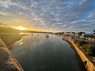
Dungarvan is a coastal town and harbour in County Waterford, on the south-east coast of Ireland. Prior to the merger of Waterford County Council with Waterford City Council in 2014, Dungarvan was the county town and administrative centre of County Waterford. Waterford City and County Council retains administrative offices in the town. The town's Irish name means "Garbhann's fort", referring to Saint Garbhann who founded a church there in the seventh century.
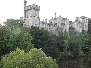
Lismore is a historic town in County Waterford, in the province of Munster, Ireland. Originally associated with Saint Mochuda of Lismore, who founded Lismore Abbey in the 7th century, the town developed around the medieval Lismore Castle. As of the 21st century, Lismore supports a rural catchment area, and was designated as a "district service centre" in Waterford County Council's 2011-2017 development plan. As of 2022, the town had a population of 1,347 people.

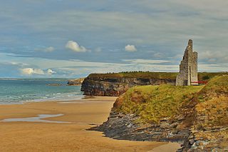
Ardmore is a seaside resort and fishing village in County Waterford, Ireland, not far from Youghal on the south coast of Ireland. It has a permanent population of around 430, that increases in the tourist season. It is believed to be the oldest Christian settlement in Ireland. According to tradition, Saint Declan lived in the region in the early 5th century, and Christianised the area before the coming of Saint Patrick.
Ballybunion or Ballybunnion is a coastal town and seaside resort in County Kerry, Ireland, on the Wild Atlantic Way, 15 km (9 mi) from the town of Listowel. As of the 2022 census, Ballybunion had a population of 1,618.
Thomastown, historically known as Grennan, is a town in County Kilkenny in the province of Leinster in the south-east of Ireland. It is a market town along a stretch of the River Nore which is known for its salmon and trout, with a number of historical landmarks in the vicinity. Visitor attractions include Jerpoint Abbey, Kilfane Glen gardens, and Mount Juliet Golf Course.

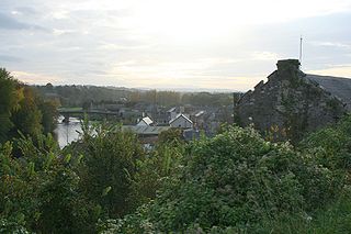
Kilmacthomas or Kilmactomas, often referred to locally as "Kilmac", is a town on the River Mahon in County Waterford, Ireland. It lies on the R677, a road north of the N25 national primary road from Dungarvan to Waterford.

Newcestown is a small village located 35 km from the city of Cork in the western part of County Cork, Ireland. It is a village with a church, a school, a pub and GAA club. Newcestown is part of the Dáil constituency of Cork North-West.

Ballyhale is a village in the south east of Ireland. Located in the south of County Kilkenny, south of the city of Kilkenny and roughly halfway to Waterford city.

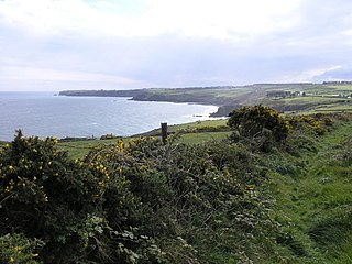
Ring or Ringagonagh is a parish within the Irish-speaking Gaeltacht na nDéise area in County Waterford, Ireland. It lies on a peninsula about eleven kilometres (7 mi) south of Dungarvan. The main settlement is the village of Ring or Ringville, which is within the townland of Ballynagaul.

Tallow is a town, civil parish and townland in County Waterford, Ireland. Tallow is in the province of Munster near the border between County Cork and County Waterford and situated on a small hill just south of the River Bride.
Villierstown is a village in west County Waterford, Ireland. It is situated on the banks of the River Blackwater, and was founded in the 1740s by a local landlord, John Villiers, as a base for the linen industry, and initially populated primarily from Lurgan. In the census of 2016, the population of the village was 276.
Aglish is a village in west County Waterford, Ireland.

Kilsheelan is a village and civil parish within the in the barony of Iffa and Offa East in County Tipperary, Ireland. It is also one half of the Roman Catholic parish of Kilsheelan & Kilcash in the Roman Catholic Diocese of Waterford and Lismore.

Ballinacourty, officially Ballynacourty, is a rural area and townland on the southern coast of Ireland near Dungarvan, County Waterford.

Grange is a small village and townland in west County Waterford, Ireland. It borders Ardmore and An Seanphobal. Ardmore and Grange are two villages that make up the Ardmore-Grange parish.

Ballyhack is a small village located in the south-west of County Wexford, in Ireland, on the eastern shore of the Waterford Harbour, which is the estuary of The Three Sisters

Old Parish is a village in west County Waterford, Ireland. It is part of the Gaeltacht in Waterford Gaeltacht na nDéise.

Gaeltacht na nDéise is a Gaeltacht area in County Waterford consisting of the areas of Ring and Old Parish. It is located 10 km from the town of Dungarvan. Gaeltacht na nDéise has a population of 1,816 people and encompasses a geographical area of 62 km2. This represents 1% of total Gaeltacht area.
Ballynagaul is a Gaeltacht area within the Irish-speaking Gaeltacht na nDéise part of County Waterford. Comprising the townlands of Baile na nGall Mór and Baile na nGall Beag, it is located approximately 9.6 kilometres southeast of Dungarvan. The village of Ring is located in the area.

