Bunmahon

Last updated

Bonmahon
Bun Machan
Village
Main Street Bunmahon - geograph.org.uk - 708592.jpg
Main Street
Ireland adm location map.svg
Red pog.svg
Bonmahon
Location in Ireland
Coordinates: 52°08′24″N7°22′19″W / 52.140°N 7.372°W / 52.140; -7.372
Country Ireland
Province Munster
County County Waterford
Time zone UTC+0 (WET)
  Summer (DST) UTC-1 (IST (WEST))

Bunmahon (Irish : Bun Machan, meaning 'river-mouth of Mahon'), [1] also called Bonmahon, is a coastal village in County Waterford, Ireland, at the mouth of the River Mahon. During the 19th century, when copper mines operated in the area, Bonmahon was a mining village. As of the 21st century, the village and its beach lie on a tourist route. [2]

Contents

History

Men at Bonmahon Mines in the early 1900s Men at Bonmahon Mines County Waterford early 1900s.jpg
Men at Bonmahon Mines in the early 1900s

Evidence of ancient settlement in the area includes a number of Ogham stone and ringfort sites in the surrounding townlands of Ballynagigla and Knockmahon. [3]

Bonmahon was a mining village for much of the 19th century, and copper and lead was mined here between 1827 and 1877. Much of the village was laid-out in this period, [4] [5] and the local Church of Ireland church was built in the 1820s. [6] A temperance hall was built in the village in 1842, and this was converted during the 1850s to become St. Mary's Roman Catholic Church. [7] [8] The population of the village swelled to over 2,000 at that time. The village was home to a pawn shop, a creamery and a bacon factory, as well as 21 public houses.[ citation needed ]

The history and mining activity of this period is covered in The Making and Breaking of a Mining Community, published in 2006. [9] One of the mine workers was Thomas Wheatley, whose son John Wheatley later went on to be Minister for Health for the first Labour Party government in the United Kingdom in 1924.

Public meeting involving mining company staff held in Bonmahon in 1906 Public meeting about Bonmahon Copper Mines Ireland 1900s (5866020082).jpg
Public meeting involving mining company staff held in Bonmahon in 1906

Places of interest

Bunmahon lies within a UNESCO Global Geopark. The Copper Coast Geopark operates a visitor centre in the village's former Church of Ireland church. The Copper Coast is home to several beaches and wildlife, including foxes, rabbits, and diverse bird species.

The local beach is used by surfers use all year round, and a surfing school runs in the summer months. The village's Tidy Towns committee has created a boardwalk along the sand dunes, as well as working to improve access to the neighbouring cove of Tra na mBó.[ citation needed ] The beach and surrounding coast is covered by the Bonmahon Unit of the Irish Coast Guard. [10]

People

See also

Related Research Articles

<span class="mw-page-title-main">County Waterford</span> County in Ireland

County Waterford is a county in Ireland. It is in the province of Munster and is part of the Southern Region. It is named after the city of Waterford. Waterford City and County Council is the local authority for the county. The population of the county at large, including the city, was 127,363 according to the 2022 census. The county is based on the historic Gaelic territory of the Déise. There is an Irish-speaking area, Gaeltacht na nDéise, in the southwest of the county.

<span class="mw-page-title-main">Ballymahon</span> Town in Leinster, Ireland

Ballymahon on the River Inny is a town in the southern part of County Longford, Ireland. It is located at the junction of the N55 National secondary road and the R392 regional road.

<span class="mw-page-title-main">Castlepollard</span> Village in County Westmeath, Ireland

Castlepollard is a village in north County Westmeath, Republic of Ireland. It lies west of Lough Lene and northeast of Lough Derravaragh and Mullingar.

<span class="mw-page-title-main">Enniscrone</span> Seaside town in County Sligo, Ireland

Enniscrone – also spelt Inniscrone and officially named Inishcrone – is a small seaside town in County Sligo, Ireland. Its sandy beach, tourist campsite, and golf course all attract visitors. As of the 2022 census, the town had a population of 1,291 people.

<span class="mw-page-title-main">Ballybunion</span> Seaside resort in County Kerry, Ireland

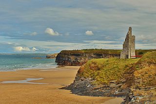
Ballybunion or Ballybunnion is a coastal town and seaside resort in County Kerry, Ireland, on the Wild Atlantic Way, 15 km (9 mi) from the town of Listowel. As of the 2022 census, Ballybunion had a population of 1,618.

<span class="mw-page-title-main">Ballintra</span> Village in County Donegal, Ireland

Ballintra is a village in the parish of Drumholm in the south of County Donegal, Ireland, just off the N15 road between Donegal town and Ballyshannon. Ballintra lies on the northern bank of the Blackwater river. The river rises in the hills that lie inland from the town, and flows through a number of small lakes before spilling over a small waterfall in a gorge behind the village.

<span class="mw-page-title-main">Stradone, County Cavan</span> Village in County Cavan, Ireland

Stradone is a village located in County Cavan, Ireland. It is situated in the civil parish of Laragh six miles from Cavan, near the N3 road between Cavan and Virginia. Stradone is classified as a 'small village' in the Cavan County Council Development Plan 2014-2020.

<span class="mw-page-title-main">Kilmacthomas</span> Town in County Waterford, Ireland

Kilmacthomas or Kilmactomas, often referred to locally as "Kilmac", is a town on the River Mahon in County Waterford, Ireland. It lies on the R677, a road north of the N25 national primary road from Dungarvan to Waterford.

<span class="mw-page-title-main">River Mahon</span> River in County Waterford, Ireland

River Mahon flows from the Comeragh Mountains in County Waterford, Ireland.

<span class="mw-page-title-main">Ballyduff, County Waterford</span> Village in County Waterford, Ireland

Ballyduff is a village in County Waterford, Ireland. It is also a parish in the Roman Catholic Diocese of Waterford and Lismore.

<span class="mw-page-title-main">Ahascragh</span> Village in County Galway, Ireland

Ahascragh is a village in east County Galway, Ireland. It is located 11 km (7 mi) north-west of Ballinasloe on the Ahascragh/Bunowen River, a tributary of the River Suck. The R358 regional road passes through the village. As of the 2022 census, it had a population of 186 people.

<span class="mw-page-title-main">Bilboa</span>

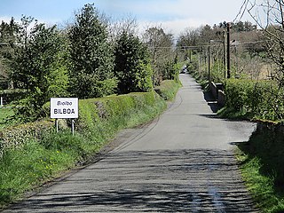
Bilboa is a settlement located on the boundaries of counties Carlow, Laois and Kilkenny in Ireland. A bridge, a short distance from the village and built c. 1800, is known as the 'Three Counties Bridge'.

<span class="mw-page-title-main">Drumone</span>

Drumone is a small village and townland in western County Meath, Ireland.

<span class="mw-page-title-main">Street, County Westmeath</span> Village in Leinster, Ireland

Street or Streete is a village and parish in County Westmeath, Ireland. It lies on the regional road between Lismacaffery and Rathowen. Its Irish name was historically anglicised as Straid or Strade.

<span class="mw-page-title-main">Copper Coast Geopark</span> Designated area in County Waterford, Ireland

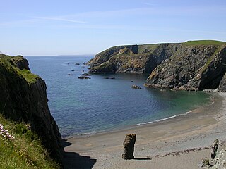
The Copper Coast Geopark is a designated area comprising a stretch of the southern coast of Ireland in County Waterford, extending for some 25 km of coastline from Kilfarrasy in the east to Stradbally in the west. It was the first geopark to be designated in the country.

<span class="mw-page-title-main">Dunkerrin</span> Village in Leinster, Ireland

Dunkerrin is a small village in County Offaly, Ireland, just south of Roscrea and near the County Tipperary border. It is on the R445 road which was once the main road from Dublin to Limerick. Dunkerrin is now bypassed by the M7, the nearest access is junction 23 at Moneygall.

John Benjamin Keane was an Irish architect of the 19th century. (d.1859). He was engineer on the River Suir navigation.

<span class="mw-page-title-main">Ladysbridge</span> Village in County Cork, Ireland

Ladysbridge, known for census purposes as Knockglass, is a village in County Cork, Ireland. As of the 2016 census, the area had a population of 658 people.

<span class="mw-page-title-main">Curry, County Sligo</span> Village in Connacht, Ireland

Curry is a village and townland in County Sligo, Ireland. The townland has an area of approximately 3.9 square kilometres (1.5 sq mi), and had a population of 148 people as of the 2011 census.

References

  1. "Bun Machan / Bunmahon". logainm.ie. Placenames Database of Ireland. Retrieved 16 February 2021.
  2. "Copper Coast Drive". dungarvantourism.com. Archived from the original on 23 January 2021. Retrieved 17 February 2021.
  3. Moore, Michael, ed. (1999). Archaeological Inventory of County Waterford. Archaeological Survey of Ireland. Government Stationery Office. ISBN   9780707662152.
  4. "Copper Coast, Templeyvrick, Bunmahon, Waterford". buildingsofireland.ie. National Inventory of Architectural Heritage. Retrieved 17 February 2021.
  5. "Mining Office, Ballynagigla, Knockmahon, Waterford". buildingsofireland.ie. National Inventory of Architectural Heritage. Archived from the original on 24 September 2021. Retrieved 17 February 2021.
  6. "Knockmahon Church, Ballynasissala, Knockmahon, Waterford". buildingsofireland.ie. National Inventory of Architectural Heritage. Archived from the original on 24 September 2021. Retrieved 17 February 2021.
  7. "Copper Coast - St. Mary's Church, Saleen, Bonmahon". copper-coast.com. Archived from the original on 30 September 2007.
  8. "Saint Mary's Catholic Church, Kilduane, Knockmahon, Waterford". buildingsofireland.ie. National Inventory of Architectural Heritage. Archived from the original on 24 September 2021. Retrieved 17 February 2021.
  9. The Making and Breaking of a Mining Community : the Copper Coast, Co. Waterford 1825-1875. Mining Heritage Trust of Ireland. 2006. ISBN   0-9534538-3-9.
  10. "Bunmahon Coast Guard Unit (Volunteer Cliff and Coastal Rescue Service of the Irish Coast Guard; IRCG)". Archived from the original on 9 November 2009. Retrieved 3 November 2009.