Ballyconneely

Last updated

Ballyconneely
Baile Conaola
Village
Keoghs Ballyconneely - Ballyconneely Townland (geograph 3117846).jpg
Keoghs, Ballyconneely
Ireland adm location map.svg
Red pog.svg
Ballyconneely
Location in Ireland
Coordinates: 53°26′00″N10°04′00″W / 53.4333°N 10.0667°W / 53.4333; -10.0667
Country Ireland
Province Connacht
County County Galway /
Time zone UTC+0 (WET)
  Summer (DST) UTC-1 (IST (WEST))
Irish Grid Reference L626445

Ballyconneely (Irish : Baile Conaola, meaning 'Conneelys' village'. Archaic name Baile 'ic Conghaile') is a village and small ribbon development in west Connemara, County Galway Ireland.

Contents

Name

19th century antiquarian John O'Donovan documents a number of variants of the village, including Ballyconneely, Baile 'ic Conghaile, Ballykineely, Ballycunneely, and Balyconneely. [1] An Post Placenames Branch archival notes Baile Uí Chonghaile, Baile 'ic Confhaola and other various spellings. [2]

The surname, Conneely is Mac Conghaile originally (Ó Conghaile contemporaneously), whereas Ó Conghaola (modern spelling Ó Conaola - Conneally) is an entirely unrelated sept located in southern County Galway belonging to the Uí bhFhiachrach Aidne. An Post archival notes local lore from the early 20th century that attests the origin of the village's name to that of Muintear Chlann Chonghaile or Clann Mhic Conghaile, [2] that is to say, the Conneelys.

Location

Settlements are spread out north on the road to Clifden and south on the road to Roundstone. This peninsula, jutting into the Atlantic Ocean between Clifden to the north and Roundstone to the south, is a mainly rural area. Its name is based on the old civil parish of Ballindoon, which in turn was named from the old fort or cashel on Doon Hill.[ citation needed ]

The area is home to several beaches: the Coral Strand at Derrygimla; west and north to Knock, Mannin, Dunloughan and Truska; and east and south from Keeraunmore, Aillebrack, and Ballyconneely Bay to Calla, Dolan and Murvey. Some of these beaches are also used for shore fishing.[ citation needed ]

History

In 1854, the first salmon farming operation in the United Kingdom was carried out on the Dohulla Fishery.

In 1919, the first transatlantic flight by Alcock and Brown ended two miles away in Derrygimla Bog, an unsuitable landing place which damaged the aircraft.

The crash landing was near the Marconi Wireless Telegraph Station [3] built in 1905, which was used to send the first transatlantic wireless message, to Cape Breton in Nova Scotia, in 1907.

A team of Dutch botanists studied lakes and water chemistry around Ballyconneelly in 1975 and throughout Ireland until 2010, due to the island's unique post-Ice Age landscape no longer found in the Netherlands. [4]

Tourism and amenities

Every July, the Ballyconneely pony show attracts people from the surrounding county to exhibit livestock and visit the travelling funfair.[ citation needed ] Ballyconneely breeds Connemara ponies, including some home and overseas champions. Legend [ citation needed ] has it that the breed originated when Arabian horses come ashore from a Spanish shipwreck near Slyne Head and bred with the small native pony.

Attractions include a 27-hole golf links, and Roundstone Bog three miles to the east, an expanse of moor, lake and stream, containing wildlife and rare plants.[ citation needed ] The beaches have edible shellfish and molluscs accessible at low tide, including clams, cockles, mussels, razorfish, sea urchins, shrimp and scallops, and with local knowledge, the occasional lobster. Connemara Smokehouse and Visitor Centre is located at Bunowen Pier, [5] a small harbour used by local fishermen and boat owners.[ citation needed ]

Two shops, a post office, a community hall, and a local parish hall make up the village centre. Other businesses in the area include a hotel, a golf course with club house, guest-houses, bed-and-breakfast establishments, and holiday homes.[ citation needed ]

Former Taoiseach Brian Cowen has a holiday home in Dunloughan, close to the Connemara Golf Links.[ citation needed ]

See also

Related Research Articles

<span class="mw-page-title-main">Connemara</span> Region in County Galway, Ireland

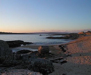
Connemara is a region on the Atlantic coast of western County Galway, in the west of Ireland. The area has a strong association with traditional Irish culture and contains much of the Connacht Irish-speaking Gaeltacht, which is a key part of the identity of the region and is the largest Gaeltacht in the country. Historically, Connemara was part of the territory of Iar Connacht. Geographically, it has many mountains, peninsulas, coves, islands and small lakes. Connemara National Park is in the northwest. It is mostly rural and its largest settlement is Clifden.

<span class="mw-page-title-main">Clifden</span> Town in County Galway, Ireland

Clifden is a coastal town in County Galway, Ireland, in the region of Connemara, located on the Owenglin River where it flows into Clifden Bay. As the largest town in the region, it is often referred to as "the Capital of Connemara". Frequented by tourists, Clifden is linked to Galway city by the N59.

<span class="mw-page-title-main">Ballynahinch, County Galway</span> Village in County Galway, Ireland

Ballynahinch or Ballinahinch is a village in County Galway in the west of Ireland. It is situated close to Recess, on the road from Recess to Roundstone. It also lies on the route of the former railway line from Galway city to Clifden. The name comes from the Irish Baile na hInse meaning settlement of the island.

The Conmhaícne Mara or Conmaicne Mara were an early people of Ireland. Their tuath was located in the extreme west of County Galway, Republic of Ireland, giving their name to Connemara, an anglicised form of Conmhaicne Mara.

<span class="mw-page-title-main">Carraroe</span> Village in Connemara, County Galway, Ireland

Carraroe is a village in Connemara, the coastal Irish-speaking region (Gaeltacht) of County Galway, Ireland. It is known for its traditional fishing boats, the Galway Hookers. Its population is widely dispersed over the Carraroe peninsula between Cuan an Fhir Mhóir and Cuan Chasla. Carraroe has an unusual beach, Trá an Dóilín, a biogenic gravel beach made of coralline algae known as "maerl".

<span class="mw-page-title-main">Connemara pony</span> Breed of horse

The Connemara pony is a pony breed originating in Ireland. They are known for their athleticism, versatility and good disposition. The breed makes excellent show ponies.

<span class="mw-page-title-main">Letterfrack</span> Village in County Galway, Ireland

Letterfrack or Letterfrac is a small village in the Connemara area of County Galway, Ireland. It was founded by Quakers in the mid-19th century. The village is south-east of Renvyle peninsula and 15 kilometres north-east of Clifden on Barnaderg Bay and lies at the head of Ballinakill harbour. Letterfrack contains the visitors centre for Connemara National Park.

<span class="mw-page-title-main">Roundstone, County Galway</span> Village in Connemara, Ireland

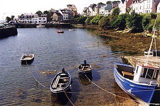
Roundstone is a village on the west coast of Ireland, in the Connemara region of County Galway. Lying opposite the island of Inishnee on Roundstone Bay, by road it is 76 kilometres (47 mi) northwest of Galway and 18 kilometres (11 mi) southeast of Clifden. Known as a haven for people in the creative arts, it hosts an annual regatta in July.

<span class="mw-page-title-main">Barna</span> Village in County Galway, Ireland

Barna is a coastal village on the R336 regional road in Connemara, County Galway, Ireland. It has become a satellite village of Galway City. The village is Irish speaking and is therefore a constituent part of the regions of Ireland that make up the Gaeltacht.

<span class="mw-page-title-main">Furbo, County Galway</span> Village in County Galway, Ireland

Furbo or Furbogh is a settlement in Connemara, County Galway, Ireland. As of the 2022 census, it had a population of 868 people. It lies along the coast, overlooking Galway Bay, in a Gaeltacht area.

<span class="mw-page-title-main">Connacht Irish</span> Irish language dialect

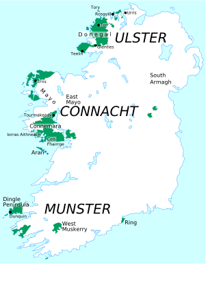
Connacht Irish is the dialect of the Irish language spoken in the province of Connacht. Gaeltacht regions in Connacht are found in Counties Mayo and Galway. Connacht Irish is also spoken in the Meath Gealtacht Ráth Chairn and Baile Ghib. The dialects of Irish in Connacht are extremely diverse, with the pronunciation, forms and lexicon being different even within each county.

<span class="mw-page-title-main">Claddaghduff</span>

Claddaghduff is a village in County Galway, Ireland. It is located northwest of Clifden, the gateway to Omey Island.

<span class="mw-page-title-main">Errisbeg</span> Mountain in western Ireland

Errisbeg Mountain or Errisbeg is a hill in Roundstone, County Galway, in the West of Ireland, with a height of 300 m.

Conneely, from or, is an Irish family name. Frequent examples of the name can be found in the West of Ireland, particularly in the Connemara area of County Galway. A coastal village in County Galway is named Ballyconneely.

Alexander Nimmo FRSE MRIA MICE HFGS was a Scottish civil engineer and geologist active in early 19th-century Ireland.

<span class="mw-page-title-main">Ó Conghalaigh</span> Surname list

Ó Conghalaigh is a Gaelic-Irish surname. It derives from the forename Conghal, meaning "fierce as a hound". It is often anglicised as Connolly, Connally, Connelly and occasionally as Conley. In modern Irish it may be spelled as Ó Conghaile.

<span class="mw-page-title-main">Toombeola</span> Townland in Connacht, Ireland

Toombeola is a townland in the historical barony of Ballynahinch in Connemara, County Galway, Ireland. It is located near the Atlantic Coast, 44 miles (71 km) west of Galway City, 4 miles (6.4 km) east of Roundstone, and 10 miles (16 km) south east of Clifden. As of the 2011 census, Toombeola townland had a population of 18 people.

<span class="mw-page-title-main">Renvyle</span> Place in County Galway, Ireland

Renvyle or Rinvyle is a peninsula and electoral division in northwest Connemara in County Galway, close to the border with County Mayo in Ireland.

<span class="mw-page-title-main">Maumeen Lough</span> Freshwater lake in the west of Ireland

Maumeen Lough is a freshwater lake in the west of Ireland. It is located in the Connemara area of County Galway.

<span class="mw-page-title-main">R341 road (Ireland)</span> Road in Ireland

The R341 road is a regional road in Ireland. It is a loop road from the N59 road in County Galway. South of the R342, the road is part of the Wild Atlantic Way.

References

  1. "People and Places of Galway". places.galwaylibrary.ie.
  2. 1 2 "Baile Conaola/Ballyconneely". logainm.ie.
  3. "The Clifden Station of the Marconi Wireless Telegraph System". Scientific American . 23 November 1907.
  4. Viney, Michael. "Dutch botanists drawn to Ireland's landscapes of special beauty". The Irish Times. Retrieved 17 October 2020.
  5. "Connemara Smokehouse and Visitor Centre - Contact Us". smokehouse.ie.