The municipality derives its name from the bamban plants (Donax canniformis) that once dominated large areas of land along the river near the foothills. It was initially called cabambanan or mabamban, but was later called simply as bamban.[6]
The site of Bamban was originally a vast track of wild land extending eastward; and on the west side, composed of forested foothills and mountains lush with tall trees extending deep into the Zambales ranges. The thick forest and mountains were then inhabited by the Aetas (locally known as Baluga), and the Zambal, both of whom subsisted only on fishing and native or wild animals which abounded in the place. Occasionally, traders from Pampanga and the Tagalog provinces braved the wilderness to go northward to Capas and Tarlac.
Before the advent of the Spanish era, small settlers came, attracted by the fertile land sustained by the river. The settlers started small clearings in the thick growth of bamban plants which covered vast portions of the land bordering the river a small distance from the foothills. Because of these plants, the place was eventually named Bamban.
Spanish colonial era
During the Spanish colonial era, about 1700, Augustinian Recollects came and established the Mission de Pueblos de Bamban. Originally a part of Pampanga, in 1837, a new boundary line was established, thereby permanently making Bamban part of the province of Tarlac.
Official recognition as a town was sanctioned by the gobernadorcillos in Tarlac town. Don Martín Sibal was subsequently appointed head and commissioned with the rank of "Capitán". Among the first settlers were the Sibal, Lugtu, Dayrit, Macale, Vergara, Manipon, Gonzales, and de la Cruz clans.
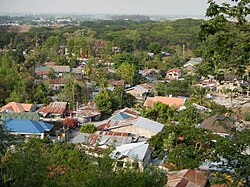
Children on roof of a school in Bamban, that was buried by lahars during the 1991 eruption of Mt. Pinatubo.
During the revolution of 1896, Bamban was one of the first towns to take up arms against the Spaniards. Northwest of the town situated among the hills are remnants of strongholds built by Bambanenses who joined Gen. Servillano Aquino in the uprising in Tarlac. Up to this time, a portion of the foothills in the area is called "Batiawan" or look-out point.
American colonial era
When the Americans came in 1900, the pueblo gradually grew into a town. The Bamban Sugar Central was established. Don Pablo Lagman was the first to be appointed presidente and Don Laureano Campo as vice-presidente under the American military government. Other prominent families then took over the helm of government. During the Commonwealth era, the Sibals, the Lumboys, the Santoses, the Punsalangs, to mention a few, enjoyed political power until the outbreak of World War II. The whole población was devastated and burned during the liberation. Rebuilding began despite the ongoing fighting in the mountains. Growth was fast because of proximity of Clark Air Base. However, prominent families left the town for the city to establish big business and names for themselves.
The Bamban barricade during the People Power revolution
Bamban played an important role during the People Power revolution because of its proximity to the Capital and to Philippine Military bases further north. In a tactically significant intervention during the revolution, 20,000 people blocked the Bamban Bridge on Feb. 25 to prevent loyalist forces from the Army's 5th Infantry Division in Tarlac from getting through to Manila to reinforce the Marcos forces surrounding Camps Aguinaldo and Crame, in an event which came to be known as "the Bamban barricade."[7]
1991 eruption of Mount Pinatubo
The 1991 eruption of Mount Pinatubo and the subsequent flow of lahar to the lowlands of Bamban forced residents to move out or to stay at the Dapdap Resettlement Area, which is on higher grounds.
Contemporary history
In 2022, a businesswoman Alice Guo was elected as mayor, which saw significant developments in town, alongside a then suspected fast-rising Philippine Offshore Gaming Operator (POGO) hub.[8] However, in 2024, she was subjected to a Senate inquiry. She was suspended over suspected links to POGO related criminal activities and questions over her Filipino citizenship and was eventually dismissed from office by the Ombudsman.[9] A court ruling in June 2025, concluded she is a Chinese citizen voiding her tenure as mayor.[10]
As her vice mayor, Leonardo Anunciacion, and seven members of the Sangguniang Bayan were also suspended for three months on the same charges, Guo was replaced by Councilor Erano Timbang, who was the only member of the Sangguniang Bayan who voted to oppose the establishment of the POGO in Bamban.[11] An interim vice mayor and other municipal councilors were also installed.[12]
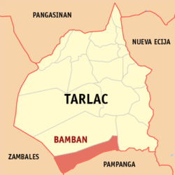
Geography
Bamban is the southernmost town of Tarlac. It shares a common boundary with Mabalacat, Pampanga, and in the west, with Zambales. The boundary is defined by the Parua River, which is a source of irrigation water, food, and sand and gravel for infrastructure projects. The mountainous region situated in the western part comprises almost two-thirds of the total land area, which used to be within the US Military Reservations. Nestled in this part are the BLISS projects and to the north, the MAR settlement project.
Bamban is 99 kilometers (62mi) from Manila and is 25 kilometers (16mi) from the provincial capital, Tarlac City.
Barangays
Dolores Grotto view of the Bamban bridge and barangays
Bamban is politically subdivided into 15 barangays, as shown below.[13] Each barangay consists of puroks and some have sitios.
In the 2020 census, the population of Bamban, was 78,260 people,[21] with a density of 310 inhabitants per square kilometer or 800 inhabitants per square mile.
The Aeta people is a noted ethnic group in Bamban, with the most known the sub-tribe being the Ayta Mag-Antsi.[22]
Parts of the Clark Special Economic Zone is in Bamban, particularly the barangays of San Vicente and Santo Niño which are partially in an area generally known as Sacobia.[31]
At the center of the town is the heritage Santo Niño Parish Church of Bamban,[32] (Vicariate of San Nicolas de Tolentino; Vicar Forane: Msgr. Francisco Tañedo[33][34][35] which was founded in 1812.
Titular: Santo Niño, Feast, Last Saturday of January.
Grotto of Our Lady of Lourdes of Bamban at Dolores
Bamban Caves and the Matayumtayum well was used by General Francisco Makabulos and his troops against the Spaniards and later on by Filipino guerrillas during the Second World War.
Education
The Bamban Schools District Office governs all educational institutions within the municipality. It oversees the management and operations of all private and public, from primary to secondary schools.[36]
This page is based on this Wikipedia article Text is available under the CC BY-SA 4.0 license; additional terms may apply. Images, videos and audio are available under their respective licenses.