Bambari

Last updated
Bambari
Bambari Downtown.jpg
Central African Republic location map.svg
Red pog.svg
Bambari
Location in Central African Republic
Coordinates: 05°45′55″N20°40′27″E / 5.76528°N 20.67417°E / 5.76528; 20.67417
Country Flag of the Central African Republic.svg Central African Republic
Prefecture Ouaka
Government
  MayorAbel Matchipata [1]
Elevation
465 m (1,526 ft)
Population
 (2012) [2]
  Total41,486

Bambari is a town in the Central African Republic, lying on the Ouaka River. It has a population of 41,356 (2003 census) and is the capital of Ouaka prefecture. Bambari is an important market town and is home to Bambari Airport, and the Roman Catholic Diocese of Bambari.

Contents

History

Anti-balaka fighters in Bambari, 2014 ABBambari.png
Anti-balaka fighters in Bambari, 2014

Bambari was electrified in 1970. [3]

On 23 December 2012 Bambari was captured by rebels from Séléka coalition. [4]

On 24 June 2014 100 Anti-balaka fighters attacked Bambari. 46 people were killed and 28 wounded. [5] In 2015 it was reported that Bambari was split with Anti-balaka controlling the part west of Oukana river and ex-Seleka controlling the eastern part of the city. [6]

On 22 February 2017 Ali Darassa and most rebels from Union for Peace in the Central African Republic withdrew from Bambari. Anti-balaka leader followed shortly after. [7] On 10 January 2019 UPC rebels attacked Bambari. The attack was repelled after seven days of battle by government and international forces. More than 40 rebels were killed. On 8 December 2020 clashes erupted between FACA and UPC rebels in Bambari resulting in a few rebels being killed. [8] On 22 December UPC took control of Bambari. [9] They withdrew day after, [10] but later returned. Government forces finally fully recaptured Bambari on 18 February 2021. [11]

Climate

Köppen-Geiger climate classification system classifies its climate as tropical wet and dry (Aw). [12]

Climate data for Bambari
MonthJanFebMarAprMayJunJulAugSepOctNovDecYear
Mean daily maximum °C (°F)33.7
(92.7)
35.3
(95.5)
34.7
(94.5)
32.4
(90.3)
31.4
(88.5)
30.5
(86.9)
29.2
(84.6)
29.7
(85.5)
30.3
(86.5)
31.
(88)
32.4
(90.3)
33.1
(91.6)
32.0
(89.6)
Daily mean °C (°F)25.3
(77.5)
27.1
(80.8)
27.5
(81.5)
26.4
(79.5)
25.8
(78.4)
25.1
(77.2)
24.4
(75.9)
24.6
(76.3)
24.7
(76.5)
25.1
(77.2)
24.7
(76.5)
24.2
(75.6)
25.4
(77.7)
Mean daily minimum °C (°F)16.9
(62.4)
19
(66)
20.4
(68.7)
20.5
(68.9)
20.2
(68.4)
19.7
(67.5)
19.7
(67.5)
19.5
(67.1)
19.2
(66.6)
19.2
(66.6)
17.1
(62.8)
15.3
(59.5)
18.9
(66.0)
Average precipitation mm (inches)10
(0.4)
30
(1.2)
80
(3.1)
105
(4.1)
174
(6.9)
171
(6.7)
194
(7.6)
221
(8.7)
228
(9.0)
209
(8.2)
41
(1.6)
8
(0.3)
1,471
(57.8)
Source: Climate-Data.org, altitude: 442m [12]

Mining

Large deposits of iron ore have been discovered in the vicinity of Bambari, though the considerable distance to the sea1500 kmprobably makes exploitatation of these reserves doubtful in the near future. A heavy duty railway and a deepwater port in a neighbouring country would be required.

The mining resource also includes iron deposits at Bakala.

See also

Related Research Articles

<span class="mw-page-title-main">Bria, Central African Republic</span> Place in Haute-Kotto, Central African Republic

Bria is the capital of Haute-Kotto, one of the 14 prefectures of the Central African Republic. As of the 2003 census the town had a population of 35,204.

<span class="mw-page-title-main">Bouar</span> Place in Nana-Mambéré, Central African Republic

Bouar is a market town in the western Central African Republic, lying on the main road from Bangui (437 km) to the frontier with Cameroon (210 km). The city is the capital of Nana-Mambéré prefecture, has a population of 40,353, while the whole sous-préfecture has a population of 96,595. Bouar lies on a plateau almost 1000m above sea level and is known as the site of Camp Leclerc, a French military base.

<span class="mw-page-title-main">Kabo</span> Town in the Central African Republic

Kabo is a town in the northern Central African Republic, lying north west of Kaga Bandoro. It is a market town and the border post for Chad.

<span class="mw-page-title-main">Bozoum</span> Place in Ouham-Pendé, Central African Republic

Bozoum is the capital of Ouham-Pendé, one of the 14 prefectures of the Central African Republic.

<span class="mw-page-title-main">Rafaï</span> Place in Mbomou, Central African Republic

Rafaï is a town and sub-prefecture on the Chinko River, in the Central African Republic prefecture of Mbomou. Its estimated population is about 14,000 people.

Ippy is a town located in the Central African Republic prefecture of Ouaka, and is located near the geographic center of the country. It is 364 kilometers from the city of Bangui directly. Driving distance, however, is 496 kilometers.

Grimari is a city located in the Ouaka prefecture in Central African Republic, approximately 222.7 kilometres (138.4 mi) away from the capital, Bangui. The politician Abel Goumba was born in Grimari.
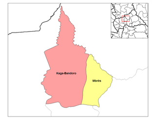
<span class="mw-page-title-main">Black Russians</span> Armed group in the Central African Republic

For other uses, see Black Russian (disambiguation).

<span class="mw-page-title-main">Anti-balaka</span> Christian militias formed in the Central African Republic

The Anti-balaka is an alliance of militia groups based in the Central African Republic in the early 21st century said to be composed primarily of Christians. However, some church leaders have contested the claimed exclusively Christian character of such groups. The Tony Blair Faith Foundation and journalist Andrew Katz have noted that animists also participate in Anti-balaka groups.

The following is a timeline of events during the Central African Republic Civil War.

<span class="mw-page-title-main">Union for Peace in the Central African Republic</span> Armed group in the Central African Republic

Union for Peace in the Central African Republic is a rebel group in the Central African Republic which controls southern parts of the country.

<span class="mw-page-title-main">Coalition of Patriots for Change</span> Rebel groups in the Central African Republic

The Coalition of Patriots for Change is a coalition of major rebel groups in the Central African Republic created in 2020 to disrupt the 2020–21 Central African general election.

<span class="mw-page-title-main">Nzacko</span> Place in Mbomou, Central African Republic

Nzacko or Nzako is a village located in the Central African Republic prefecture of Mbomou on the road between Bakouma and Bria.

Gaga is a village located in the Central African Republic prefecture of Ombella-M'Poko. Artisanal gold mining is active in the commune.

Between 6 and 16 December 2021, a number of Muslim civilians were killed and injured by Anti-balaka fighters supported by government forces and Russian mercenaries in the Boyo commune, located in the Ouaka prefecture of the Central African Republic (CAR). These civilians were attacked for their alleged links with Union for Peace in the Central African Republic (UPC) rebels. The attacks are part of the larger CAR Civil War which has been ongoing since 2012.

<span class="mw-page-title-main">Ngakobo</span> Place in Ouaka, Central African Republic

Ngakobo is a town located in Ouaka Prefecture, Central African Republic.

Batobadja is a village situated in Ouaka Prefecture, Central African Republic.

Lioto, also spelled Liotto or Lihoto, is a village situated in Ouaka Prefecture, Central African Republic.

<span class="mw-page-title-main">Pavica</span> Place in Basse-Kotto, Central African Republic

Pavica, also spelled Pavika, is a village situated in Basse-Kotto Prefecture, Central African Republic.

References

  1. "le procureur de Bambari, le magistrat Olivier Mbombo, n'a pas été "gravement tabassé" par des russes". 30 July 2022.
  2. "World Gazetteer". Archived from the original on January 11, 2013.
  3. Rius, Juan Fandos; Bradshaw, Richard (2016). Historical Dictionary of the Central African Republic. Maryland: Rowman & Littlefield. p. 251. ISBN   9780810879928.
  4. "CAR rebels seize biggest, most southern town yet". Reuters. 23 December 2012. Archived from the original on 24 December 2012. Retrieved 26 December 2012.
  5. Report of the Secretary-General on the situation in the Central African Republic Archived 2021-09-29 at the Wayback Machine , 1 August 2014
  6. “One day, we will start a big war”
  7. Report of the Secretary-General on the Central, 2 June 2017
  8. "RCA : Bambari, les soldats FACA et les rebelles de l'UPC renforcent leurs positions". 10 December 2020.
  9. "Alerte info : la ville de Bambari (Centre) vient de tomber aux mains des rebelles". 22 December 2020.
  10. "RCA : retour au calme à Bambari après le départ des rebelles". 23 December 2020.
  11. "RCA : Bambari, les rebelles se retirent complètement de la ville et occupent les villages périphériques". 18 February 2021.
  12. 1 2 "Climate: Bambari - Climate graph, Temperature graph, Climate table". Climate-Data.org. Archived from the original on 2013-10-21. Retrieved 21 October 2013.

05°45′55″N20°40′27″E / 5.76528°N 20.67417°E / 5.76528; 20.67417