
Basaveshwaranagara, also known as Basaveshwaranagar, Basaveshnagara or Basaveshnagar is a largely residential neighbourhood in the west of Bengaluru, Karnataka, India. It is located to the west of Rajajinagara and is sandwiched between the localities of Mahalakshmi Layout to the north and Vijayanagara to the south, spread across multiple sub-localities, three assembly constituencies and seven Bruhat Bengaluru Mahanagara Palike (BBMP) wards. The area of Basaveshwaranagara is often considered West of Chord Road as it lies to the west of Chord Road, an arterial road in the western part of Bengaluru.

The Bangalore Development Authority (BDA) of Bangalore, India, is a governmental organization and the principal planning authority for Bangalore. Its function, under the Karnataka Town and Country Planning Act of 1961, is as a regulatory body required "to prepare in the prescribed manner a Comprehensive Development Plan" for the Bangalore Metropolitan Region. It also oversees planning and development of infrastructure, provision of development-related sites and services, the housing needs of underprivileged citizens in Bangalore and is currently the city's largest land developer. No other authority or person may undertake development within the Bangalore Metropolitan Region without the permission of the BDA.

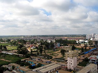
Bruhat Bengaluru Mahanagara Palike (BBMP) is the administrative body responsible for civic amenities and some infrastructural assets of the Greater Bengaluru metropolitan area. It is the fourth largest Municipal Corporation in India and is responsible for a population of 8.4 million in an area of 741 km2. Its boundaries have expanded more than 10 times over the last six decades.

Krishnarajapuram often abbreviated as K R Puram or K R Pura, is an eastern neighborhood of Bangalore, the capital of the Indian state of Karnataka. It is one of the zones of BBMP. It is located 15 km (9.3 mi) from Bangalore City railway station. The Old Madras Road passes through this locality. A lake called 'Vengayyana Lake' is in the heart of this area. The Yele Mallappa Shetty Lake near Medahalli, situated just outside the eastern limits of KR Pura, is one of the largest lakes in Bangalore.
Vidyaranyapura is situated in the northern part of Bangalore city in the state of Karnataka, India. Vidyaranyapura, along with several other extensions of the city, comes under a constituency called Byatarayanapura. It comes under the Greater Bangalore jurisdiction of the Bruhat Bengaluru Mahanagara Palike (BBMP).
Kodigehalli is a suburb of Bangalore(B.B.M.P. Ward 8). Historic temples and modern constructions are cheek by jowl. Kodigehalli is to the south of Sahakarnagar. The new airport road to Kodigehalli main road via Kodigehalli circle connects the Kodigehalli area.
Located in South Bangalore, Karnataka, India, Kumaraswamy Layout is a sub locality in Banashankari.
Bellandur is a suburb in south-east Bangalore, Karnataka, India. It is bounded by HSR Layout to the west, Devarabisanahalli to the east, Sarjapur Road to the south, and the Bellandur Lake to the north. The Bellandur Lake is the largest lake in Bangalore, and separates Bellandur from the HAL Airport. The Outer Ring Road passes through Bellandur, making the area an important transit point between east and south Bangalore.

Ramamurthy Nagar ( ) is an area in Bangalore in the Indian state of Karnataka. It is located in the eastern part of Bangalore and comes under the E3 subdivision of BBMP. It is a rapidly growing suburb, adjacent to other areas such as Banaswadi, CV Raman Nagar and Krishnarajapuram, also officially called Krishnarajapura.
Lavelle Road is an upmarket residential and commercial street in the city of Bangalore, Karnataka in India. It is an important connection between Mahatma Gandhi Square and Richmond Circle. The road starts from the Queens Road end of the M. Chinnaswamy Stadium and after curving in a serpentine manner meets the junction of Bangalore Club with Richmond Circle. Lavelle Road was named after Michael F Lavelle, an Irish soldier who later made his money in the Kolar Gold Fields.
Cox Town, Bengaluru is a neighborhood of the Bangalore Cantonment, located in the central part of the city and named after the last Collector and District Magistrate of the Bangalore Civil and Military Station, Alexander Ranken Cox, Indian Civil Services. It is one of the suburbs which came out of the plan to de-congest thickly populated areas of the Bangalore Cantonment after the bubonic plague. Agricultural fields were converted for this purpose, and town was planned according to modern hygienic standards, with drainage and conservancy conveniences. Sarvagnanagara is bound by the Bangalore-Madras Railway line on the North and East, Wheeler Road in the East and the Ulsoor Polo Ground in the South. It consists of posh localities like Heerachand Layout and other localities like Sindhi Colony, Jeevanahalli, Doddigunta, and roads such as Assaye Road, Charles Campbell Road, Wheeler Road, etc. and is adjoining the suburbs of Pulakeshi Nagara, Sri Krishnaraja Wadiyar Nagara and Cooke Town, with easy access to the Bengaluru East Railway Station, Halasuru, Lingarajapura, Shivajinagara. Sarvagnanagara is a well planned, posh and preferred locality in the Bangalore Cantonment, created during the British Raj. The residents of Sarvagnanagara follow a liberal 'live a let live' attitude, with suburb still retaining much of its green cover, without excessive commercialisation. In 1988, the BBMP renamed Cox Town as Sarvagnanagara, after a 16th-century saint poet.
Gandhi Nagar is a locality situated in Bangalore. It is a bustling neighbourhood of Central Bangalore.
Kammanahalli is a locality located in the north-eastern part of the Indian city of Bangalore, Karnataka. It is bound by Kalyan Nagar, Banaswadi, HRBR Layout, HBR Layout, Maruthi Seva Nagar, Jeevanahalli, Hennur, Cox Town, Cooke Town, and Lingarajapuram. The locality is home to one of the most religiously and ethnically diverse communities, with multiple churches, temples, and mosques in the vicinity, hence having earned the nickname "Kammanhattan". Kammanahalli is considered as a bustling cosmopolis with multiple retail shops, malls, residential areas, eateries, pubs, bars, and activities.
Lingarajapuram is a locality located in the north-eastern part of the city of Bangalore, on the outskirts of the Bangalore Cantonment. It is bound by Cooke Town, Fraser Town,Banaswadi,Kammanahalli and Devara Jeevanahalli. Sub-localities include St Thomas Town,Sagayapuram,Jalavayu Vihar and Kacharakanahalli. The Lingarajapuram Flyover, which acts one of the thoroughfares connecting the north-eastern suburbs with the city, witnesses bottleneck traffic congestion during peak hours.

Banaswadi railway station is an Indian Railways train station located in Banaswadi, Bangalore, in the Indian state of Karnataka, which is about 12 km away from the Bangalore City railway station and serves the Banaswadi and Baiyyappanahalli areas.

Yelahanka Ward, officially known as Kempegowda Ward is one of the 225 Wards of Bruhat Bengaluru Mahanagara Palike, an administrative body responsible for civic amenities and some infrastructural assets of the Greater Bangalore metropolitan area in the Indian state of Karnataka.
Baiyyappanahalli or New Baiyyappanahalli Extension is one of the neighbourhoods in Bengaluru,located in the eastern part of the city. It is part of C. V. Raman Nagar in East Bengaluru. The area is a transport hub and popular for Baiyappanahalli metro station and Baiyyappanahalli railway station.
Baiyyappanahalli Manavarthe Kaval or Old Baiyyappanahalli is one of the early settlements in Bengaluru. It is part of C. V. Raman Nagar Assembly constituency in East Bengaluru. This former village was included in the Bangalore Mahanagara Palike on 7 December 1995.
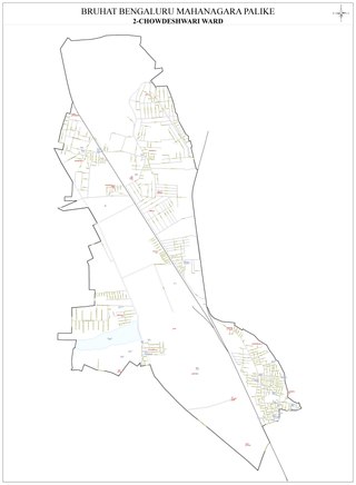
Chowdeshwari Ward, is one of the 198 Wards of Bruhat Bengaluru Mahanagara Palike, an administrative body responsible for civic amenities and some infrastructural assets of the Greater Bangalore metropolitan area in the Indian state of Karnataka.

Attur Ward, is one of the 198 Wards of Bruhat Bengaluru Mahanagara Palike, an administrative body responsible for civic amenities and some infrastructural assets of the Greater Bangalore metropolitan area in the Indian state of Karnataka.
