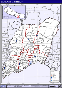
Sarlahi, a part of Madhesh Province, is one of the seventy-seven districts of Nepal. According to new laws, a combination of more than two or four villages makes a municipality, which covers an area of 1,259 km2 (486 sq mi) and had a population of 635,701 in 2001,769,729 in 2011 and 862,470 in 2021.

A village development committee in Nepal was the lower administrative part of its Ministry of Federal Affairs and Local Development. Each district had several VDCs, similar to municipalities but with greater public-government interaction and administration. There were 3,157 village development committees in Nepal. Each village development committee was further divided into several wards depending on the population of the district, the average being nine wards.
Chapakot is a municipality in the southeastern part of Syangja District in Gandaki Province of central Nepal. The new municipality was formed by merging three existing villages—Ratnapur, Kuwakot and Chapakot—on 18 May 2014. In 12 March 2017 The government implemented the new local administrative structure consisting of 744 local units. With the implementation of this new local administrative structure, the old structure will no longer be in existence. According to the new structure, VDCs will be replaced with village councils. Newly merged VDCs are Sankhar, Sekham, Ward no. 8 of Pakbadi & Ward no. of Malyangkot. The office of the municipality is that of the former Chapakot Municipality.
Rupakot is a village development committee in Tanahu District in Gandaki Province of central Nepal. At the time of the 1991 Nepal census it had a population of 4765 people living in 937 individual households. The VDC has been merged with existing Bhanu village development committees(VDCs), Barbhanjyang village development committees (VDCs) Tanahunsur Village Development Committee, Purkot VDC, Mirlung VDC, Satiswara VDC, Risti VDC, Basantapur VDC and Chok Chisapani VDC on 19 September 2015 to form Bhanu Municipality.
Hajariya is a village development committee (VDC) in Sarlahi District in the Janakpur Zone of south-eastern Nepal. Now it is included to barahathwa municipality. At the time of the 2011 Nepal census it had a population of 16,336 people living in 2814 individual households.
Sukhipur is a municipality in Siraha District in the Madhesh Province of south-eastern Nepal. After the government announcement the municipality was established on 19 September 2015 by merging the existing Mohanpur Kamalpur, Vidhyanagar, Kushaha Laksiminiya, Kabilasi, Silorba Pachhawari Balhi and Sukhipur village development committees (VDCs). The center of the municipality is established in Sukhipur Bazaar. At the time of the 2011 Nepal census after merging the seven VDCs population it had a total population of 20,915 persons. After the government decision the number of municipalities has reached 217 in Nepal.
Gauradaha is a municipality in Jhapa District in the Province No. 1 of eastern Nepal. After the government announcement the municipality was established on 19 September 2015 by merging the existing Maharanijhoda, Baigundhura, Juropani, Kohabara and Gauradaha village development committees (VDCs). The center of the municipality is established in the mid of Gauradaha, Dhobiniya chowk. At the time of the 2021 Nepal census after merging the four VDCs population it had a total population of 47,393 persons. After the government decision the number of municipalities has reached 217 in Nepal.

Belbari, officially known as Belbari municipality, is one of the major suburb of Morang district, Province No. 1. It lies in the eastern Terai region of Nepal. Previously a Village Development Committee (VDC), it was upgraded to the municipality status in 2014. In order to meet the requirements to become a municipality, Belbari VDC merged Kaseni VDC with itself, making it larger in total area. Moreover, in 2017 AD VDC like Dangihat and Bahuni merged with it to become present Belbari Municipality. Now it have 11 wards offices. It had a population of 81,837 people living in 18,945 households making it the third most populous city in Morang district.
Kolhuwa is a village development committee in Nawalparasi District in the Lumbini Zone of southern Nepal. At the time of the 1991 Nepal census it had a population of 6,292 people living in 1,025 individual households. .This VDC was merged in the Madhyabindu municipality on 19 September 2015 along with Tamasariya and Narayani Village development committees (VDCs). The center of the municipality is established in the former Tamasariya VDC of Chormara Bazaar. After merging the three VDCs population it had a total population of 28,224 according to 2011 Nepal census.
Mithila is a municipality in Danusha District in Madhesh Province of south-eastern Nepal. After the government announcement the municipality was established on 2 December 2014 by merging the existing Begadawar, Nakatajhijh and Dhalkebar village development committees (VDCs). At the time of the 2011 Nepal census after merging the three VDCs population it had a total population of 31,575 persons. After the government decision the number of municipalities has reached 191 in Nepal.

Laligurans is a municipality located in Terhathum District in the Koshi Province of eastern Nepal. After the government announcement, the municipality was established on 19 September 2015 by merging the existing Basantapur, Phulek, Dangpa, Sungnam and Solma village development committees (VDCs). The center of the municipality is established in Basantpur. At the time of the 2011 Nepal census after merging the five VDCs population it had a total population of 16,934 persons. After the government decision the number of municipalities has reached 217 in Nepal.
Dhangadhimai Municipality is a municipality in Siraha District in Madhesh Province of eastern Nepal. After the government announcement the municipality was established on 19 September 2015 by merging the existing Bhawanipur, Hanuman Nagar, Phulkaha Kati, Dhangadi and Bishnupurkati village development committees (VDCs). The center of the municipality is established in Dhangadhi Bazaar. At the time of the 2011 Nepal census after merging the four VDCs population it had a total population of 47,449 persons. After the government decision the number of municipalities has reached 217 in Nepal.

Bhanu is a municipality of Tanahun District in Gandaki Province of western Nepal. The municipality was established on 19 September 2015 by merging the existing Bhanu village development committee or VDC, Barbhanjyang VDCs, Rupakot (VDC), Tanahunsur Village Development Committee, Purkot VDC, Mirlung VDC, Satiswara VDC, Risti VDC, Basantapur VDC and Chok Chisapani VDC. The center of the municipality is established in former VDC Office of Bhanu. After merging the population of all of the VDCs, it had a total population of 46,179 according to 2011 Nepal census. After the government decision the number of municipalities has reached 217 in Nepal. Nepali poet Bhanubhakta Acharya was born in Bhanu Municipality. It was named after him.

Karaputar was a municipality of Lamjung District in Gandaki Province of central Nepal. The municipality was established on 19 September 2015 by merging the existing Bangre, Bhorletar, Isaneshwor and Karapu village development committees (VDCs). The center of the municipality was established in the former VDC Office of Karapu Bazaar. After merging the four VDC's population it had a total population of 10,836 according to 2011 Nepal census. After the government decision the number of municipalities has reached 217 in Nepal. This municipality finally merged with Madhyanepal municipality on 10 March 2017. Madhyanepal established the same day with part of Karaputar municipality.
Rainas is a municipality of Lamjung District in Gandaki Province of central Nepal. The municipality was declared on 19 September 2015 by merging the existing six VDCs of Eastern Lamjung, Tarkughat, Dhamilikuwa, Chakratirtha, Bhalayakharka, Pyarjung and Mohoriyakot having a total of 73 square km area. The center of this municipality has been established in Tinpiple of Chakratirth VDC. Rainas has a total population of 18,527 and population density of 254 person/km2 according to 2011 Nepal census.

Madhyabindu is a municipality of Nawalpur District in Lumbini Zone of southern Nepal. The municipality was established on 19 September 2015 by merging the existing Tamasariya, Naya Belahani and Kolhuwa village development committees (VDCs). The center of the municipality is established in the former Tamasariya VDC of Chormara Bazaar. After merging the three VDCs population it had a total population of 28,224 according to 2011 Nepal census. After the government decision the number of Sub Metropolitan cities and municipalities has reached 12 and 217 respectively in Nepal.

Bhrikuti Municipality is a municipality in Kapilvastu District in Lumbini Province of Nepal that was established on 19 September 2015 by merging the two former Village development committees Budhi, Hariharpur, Rajpur and Barakulpur. The administrative center of the municipality lies in the former Budhi VDC of Hanuman Bazaar area. At the time of the 2011 Nepal census it had a population of 26,282 people. The municipality is named after Bhrikuti, the first wife of the earliest emperor of Tibet.
Chaudandigadhi is a municipality in Udayapur District of Province No. 1 in Nepal that was established on 10 March 2017 by merging the former Village development committees Chaudandi, Siddipur, Hadiya and Sundarpur with the former municipality Beltar Basaha. At the time of the 2011 Nepal census, the localities out of which Chaudandigadhi would be formed had a joint population of 48,574 people living in 10,519 individual households. It is surrounded by Belka Municipality in the east, Triyuga in the west, the districts of Khotang and Bhojpur in the north and Sunsari District in the south.
Sundar Haraicha is a municipality in Morang District of Koshi Province in Nepal. It is centered around Biratchowk town which is the gateway to Biratnagar. It borders Itahari Sub- Metropolitan city to the west, Dharan Sub- Metropolitan city to the Northwest and Belbari municipality to the east and is connected by Mahendra Highway. It is one of the fastest growing cities in eastern Nepal and the second largest city of Morang district after Biratnagar, with 121,305 inhabitants living in 26,677 households. It consists of the town centres of Biratchowk and Gothgaun which are parts of the Greater Birat Development Area which incorporates the cities of Biratnagar-Itahari-Gothgau-Biratchowk-Dharan primarily located on the Koshi Highway in Eastern Nepal, with an estimated total urban agglomerated population of 804,300 people living in 159,332 households.
Mithila Bihari is a municipality in Danusha District in Madhesh Province of Nepal. It was formed in 2016 occupying current 10 Sections (Wards) from previous 10 VDCs. It occupies an area of 37.60 km2 with a total population of 37,276. Dhanusha district, located in the central part of the Janakpur region, which is one of the development regions of Nepal, is bordered by southern India. There are 18 local levels located in the central part of the Dhanusha district, which were part of the Madhyamanchal Development Region. Among them, six Village Development Committees (VDCs) - Bhutahi Paterwa, Mithileshwar Nikas, Andupatti, Tarapatti Sirsiya, and Mithileshwar Mauwahi - have been merged to form the Mithila Bihari Municipality under the Madhesh Province of Nepal as of Falgun 27, 2073 B.S. Despite being situated in the easily accessible terrain of the Terai region in terms of geographical features, Mithila state has a densely populated settlement from the perspective of human development indicators and progress. In the historic pilgrimage of Mithila state, which includes two main Dolis (Processions) or travel camps, such as the Mela, established with the name of Lord Bihari from Mithila Bihari, the city of Janakpur, which is recognized as the holy place of the Hindu religion, meaning the father-in-law's place of Lord Ram, has given additional identity to the Mithila Bihari. From a religious point of view, Mithila Bihari has been named after Lord Ram, who is historically recognized, which has resulted in the naming of this local place as Mithila Bihari. Published in the Rajpatra on Jestha 11, 2074 B.S., upgrading the Mithila Bihari Rural Municipality to the Municipality level was not possible, but an interim order of the Supreme Court issued on Bhadra 27, 2074 B. S. resulted in the transformation of Mithila Bihari Rural Municipality into a Municipality.