Barbours Creek-Shawvers Run Cluster

Last updated
Barbours Creek-Shawvers Run Cluster
USA Virginia relief location map.svg
Red pog.svg
Location of Barbours Creek-Shawvers Run Cluster in Virginia
Location Allegheny County
Botetourt County
Craig County
Virginia, United States
Coordinates 37°36′53″N80°6′52″W / 37.61472°N 80.11444°W / 37.61472; -80.11444
AdministratorU.S. Forest Service

The Barbours Creek-Shawvers Run Cluster is a region in the Jefferson National Forest recognized by The Wilderness Society for its unique high elevation mountains, vistas, trout streams and wildlife habitat. With over 25,000 acres in a remote corner of the national forest, the cluster provides protection for black bear, clean water and backcountry hiking. [1] [2]

Contents

Description

The Barbours Creek/Shawvers Run Wilderness Cluster contains wilderness areas, and wildlands recognized by the Wilderness Society as "Mountain Treasures", areas that are worthy of protection from logging and road construction. [1]

The areas in the cluster are:

Location and access

1983 Map of the north portion of the Jefferson National Forest in southwest Virginia 1983 Map of the north portion of the Jefferson National Forest in southwest Virginia.jpg
1983 Map of the north portion of the Jefferson National Forest in southwest Virginia

The cluster is about six miles north of New Castle. Roads and trails are given on National Geographic Maps 788 (Covington, Alleghany Highlands). [4] A great variety of information, including topographic maps, aerial views, satellite data and weather information, is obtained by selecting the link with the wild land's coordinates in the upper right of this page.

Biological significance

The landform, climate, soils and geology of the Appalachian highlands, as well as its evolutionary history, have created one of the most diverse collection of plants and animals in the deciduous forests of the temperate world. [5]

At one time the American chestnut was a dominant part of the forest, but it was almost eliminated during the first three decades of the twentieth century by a chestnut blight fungus. Now the area is dominated by different species of oak. [5]

Geologic history

Extending along the western boundary of Virginia, the Ridge and Valley province is composed of long, relatively level-crested, ridges with highest elevations reaching over 3600 feet. The province marks the eastern boundary in the Paleozoic era of an older land surface on the east. It was uplifted and eroded during the Paleozoic with extensive folding and thrust faulting. Resistant quartzite, conglomerates and sandstones form the ridge caps while less resistant shales and limestones eroded to form the intervening valleys. [5]

The area is part of the James River drainage. Shawvers Run is a tributary of Potts Creek, which flows into the James River. Barbours Creek flows into Craig Creek, a tributary of the James River. [4]

Toms Knob

Toms Knob is a wild area that extends into both the James River District of the George Washington National Forest and the Eastern Divide District of the Jefferson National Forest. A review by the wilderness society of areas in the George Washington National Forest recognized the area as a "Mountain Treasure". Named after a series of rock outcrops on the crest of Potts Mountain, the knob offers good views of the Potts Creek Valley and Peters Mountain on the west. The Potts Mountain Jeep Road, running along the crest of Potts Mountain, separates the area from the Barbours Creek Wilderness. The highest elevation is about 3800 feet on the crest of Potts Mountain; the lowest elevation is 1750 feet in Shanty Hollow on the northeast corner of the area. [3]

The area includes a small Special Biological Area on the crest of the ridge, as well as small areas of potential old-growth trees. [3]

There are a few short trails in the Shanty Hollow area, in the northeastern tip of the area. Trails include: [4]

Black bear

American black bear - FWS American black bear - FWS.jpg
American black bear - FWS

The cluster's large area provides essential habitat for the black bear population, an umbrella species contributing to the biological diversity of the Appalachians. [3]

The area gives bear a refuge from human activities, and the availability of critical food in the form of acorns from oaks, as well as spring and summer foods such as blueberries, blackberries, pokeweed and huckleberries. Bears require space for escape cover and winter dens. Without the forest lands in the Appalachians, the black bear population would be threatened. [3]

Steel Bridge Recreation Area

The recreation area, on Potts Creek, is at the north end of Shawvers Run Wilderness. Visitors on hot summer days can wade in the cold water of Potts Creek or enjoy fishing in pools beneath rock overhangs along the banks of Potts Creek. There are 20 primitive campsites with tables, fireplaces, hand-pumped water and pit toilets. The area is open year-around. [6]

See also

Unprotected Wildlands in the George Washington National Forest

Other clusters

Other clusters of the Wilderness Society's "Mountain Treasures" in the Jefferson National Forest (north to south):

Related Research Articles

<span class="mw-page-title-main">George Washington and Jefferson National Forests</span> Pair of National Forests in the United States

The George Washington and Jefferson National Forests is an administrative entity combining two U.S. National Forests into one of the largest areas of public land in the Eastern United States. The forests cover 1.8 million acres (2,800 sq mi) of land in the Appalachian Mountains of Virginia, West Virginia, and Kentucky. Approximately 1 million acres (1,600 sq mi) of the forest are remote and undeveloped and 139,461 acres (218 sq mi) have been designated as wilderness areas, which prohibits future development.

<span class="mw-page-title-main">Barbours Creek Wilderness</span>

Barbours Creek Wilderness is a U.S. wilderness area in the Eastern Divide Ranger District of George Washington and Jefferson National Forests of western Virginia, United States. The wilderness area was established in 1988 and consists of 5,382 acres (2,178 ha) of forests in the Appalachian Mountains ranging in elevation from 1,700 to 3,800 feet.

<span class="mw-page-title-main">James River Face Wilderness</span>

The James River Face Wilderness is an 8,907-acre area located near Natural Bridge, Virginia that is protected by the Eastern Wilderness Act of Congress to maintain its present, natural condition. As part of the National Wilderness Preservation System, it helps to preserve a variety of natural life forms and contributes to a diversity of plant and animal gene pools. Over half of the ecosystems in the United States exist within designated wilderness.

<span class="mw-page-title-main">Shawvers Run Wilderness</span>

The Shawvers Run Wilderness, a 5784-acre area located less than one mile south of Potts Creek, Virginia, is protected by the Eastern Wilderness Act of Congress to maintain its present, natural condition. As part of the National Wilderness Preservation System, it helps to preserve a variety of natural life forms and contributes to a diversity of plant and animal gene pools. Over half of the ecosystems in the United States exist within designated wilderness.

<span class="mw-page-title-main">Mount Rogers Cluster</span> Protected natural area in Virginia, United States

The Mount Rogers Cluster is a region recognized by The Wilderness Society for its unique high elevation mountains, vistas, trout streams and wildlife habitat. The heart of the region is Mount Rogers, the highest mountain in Virginia. The area extends over the Mount Rogers National Recreation Area and into part of the Cherokee National Forest.

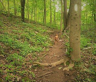
Spesard Knob, a wildland in the George Washington and Jefferson National Forests of western Virginia, has been recognized by the Wilderness Society as a special place worthy of protection from logging and road construction. The Wilderness Society has designated the area as a "Mountain Treasure".

<span class="mw-page-title-main">Craig Creek Cluster</span> Protected natural area in Virginia, United States

The Craig Creek Cluster is a region recognized by The Wilderness Society for its unique high elevation mountains, vistas, trout streams and wildlife habitat. The cluster contains wildlands and wilderness areas along Craig Creek, a 65-mile long creek with headwaters at the Brush Mountain Wilderness near Blacksburg.

Hoop Hole, a wildland in the George Washington and Jefferson National Forests of western Virginia, has been recognized by the Wilderness Society as a special place worthy of protection from logging and road construction. The Wilderness Society has designated the area as a "Mountain Treasure".

Barbours Creek Wilderness Addition, a wildland in the George Washington and Jefferson National Forests of western Virginia, has been recognized by the Wilderness Society as a special place worthy of protection from logging and road construction. The Wilderness Society has designated the area as a "Mountain Treasure".

Potts Arm, a wildland in the George Washington and Jefferson National Forests of western Virginia, has been recognized by the Wilderness Society as a special place worthy of protection from logging and road construction. The Wilderness Society has designated the area as a "Mountain Treasure".

Sinking Creek Mountain, a wildland in the George Washington and Jefferson National Forests of western Virginia, has been recognized by the Wilderness Society as a special place worthy of protection from logging and road construction. The Wilderness Society has designated the area as a "Mountain Treasure".

Johns Creek Mountain, a wildland in the George Washington and Jefferson National Forests of western Virginia, has been recognized by the Wilderness Society as a special place worthy of protection from logging and road construction. The Wilderness Society has designated the area as a "Mountain Treasure".

<span class="mw-page-title-main">Sinking Creek Valley Cluster</span> Protected natural area in Virginia, United States

The Sinking Creek Valley Cluster is a region in the Jefferson National Forest recognized by The Wilderness Society for its unique recreational and scenic values as well as the importance of its watershed protection for Johns Creek and Craig Creek. Sinking Creek Valley is one of the most scenic valleys in Virginia.

Dismal Creek, a wildland in the George Washington and Jefferson National Forests of western Virginia, has been recognized by the Wilderness Society as a special place worthy of protection from logging and road construction. The Wilderness Society has designated the area as a "Mountain Treasure".

<span class="mw-page-title-main">Angels Rest Cluster</span> Protected natural area in Virginia, United States

The Angels Rest Cluster is a region in the Jefferson National Forest recognized by The Wilderness Society for its diversity of habitats with steep mountains, an isolated valley, a waterfall and wetlands. It is named after a high point on Pearis Mountain with views of the New River and surrounding area. It contains two large wild areas connected by the Appalachian Trail.

<span class="mw-page-title-main">Crawfish Valley (Bear Creek)</span> Protected natural area in Virginia, United States

Crawfish Valley, a wildland in the George Washington and Jefferson National Forests of western Virginia, has been recognized by the Wilderness Society as a special place worthy of protection from logging and road construction.

<span class="mw-page-title-main">Walker Mountain Cluster</span> Protected natural area in Virginia, United States

The Walker Mountain Cluster is a region in the Jefferson National Forest recognized by The Wilderness Society for its diversity of habitats extending along Walker Mountain. The mountain, part of the Appalachian Mountains in southwest Virginia, borders the western side of the Great Valley of Virginia. Interstate 81 traverses the Great Valley as it takes travelers between Tennessee and West Virginia.

Brushy Mountain, a wildland in the George Washington and Jefferson National Forests of western Virginia, has been recognized by the Wilderness Society as a special place worthy of protection from logging and road construction. The Wilderness Society has designated the area as a "Mountain Treasure".

The Kimberling Creek Cluster is a region in the Jefferson National Forest recognized by The Wilderness Society for its diversity of habitats extending along parts of Brushy and Hogback Mountains. Kimberling Creek, with headwaters in the cluster, flows into Big Walker Creek, a tributary of the New River.

Beartown Wilderness Addition B, a wildland in the George Washington and Jefferson National Forests of western Virginia, has been recognized by the Wilderness Society as a special place worthy of protection from logging and road construction. The Wilderness Society has designated the area as a "Mountain Treasure". The area. adjacent to the Beartown Wilderness, is proposed as an addition to the wilderness.

References

  1. 1 2 3 Parsons, Shireen (May 1999). Virginia's Mountain Treasures, The Unprotected Wildlands of the Jefferson National Forest. Washington, D. C.: The Wilderness Society, OCLC: 42806366. p. 27.
  2. Bamford, Sherman (February 2013). A Review of the Virginia Mountain Treasures of the Jefferson National Forest. Blacksburg, Virginia: Sierra Club, OCLC: 893635467.
  3. 1 2 3 4 5 Miller, Mark. Virginia's Mountain Treasures, The Unprotected Wildlands of the George Washington National Forest,. Washington, D. C.: The Wilderness Society. p. 81.
  4. 1 2 3 Trails Illustrated Maps (2001). Covington, Alleghany Highlands (Trails Illustrated Hiking Maps, 788). Washington, D. C.: National Geographic Society.
  5. 1 2 3 Stephenson, Steven L.; Ash, Andrew N.; Stauffer, Dean F. (1993). Appalachian Oak Forests, Chapter 6 in Biodiversity of the Southeastern United States, Upland Terrestrial Communities edited by Martin, Boyce and Echternacht. New York, NY: John Wiley and Sons. pp.  255-264. ISBN   0-471-58594-7.
  6. Winegar, Deane and Garvey (1998). Highroad Guide to the Virginia Mountains . Marietta, Georgia: Longstreet Press, Inc. p.  143. ISBN   1-56352-462-7.

Further reading