
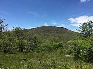
Mount Rogers is the highest natural point in Virginia, United States, with a summit elevation of 5,729 feet (1,746 m) above mean sea level. The summit straddles the border of Grayson and Smyth Counties, Virginia, about 6.45 miles (10.38 km) WSW of Troutdale, Virginia. Most of the mountain is contained within the Lewis Fork Wilderness, while the entire area is part of the Mount Rogers National Recreation Area, which itself is a part of the Jefferson National Forest.

The George Washington and Jefferson National Forests is an administrative entity combining two U.S. National Forests into one of the largest areas of public land in the Eastern United States. The forests cover 1.8 million acres (7,300 km2) of land in the Appalachian Mountains of Virginia, West Virginia, and Kentucky. Approximately 1 million acres (4,000 km2) of the forest are remote and undeveloped and 139,461 acres (564 km2) have been designated as wilderness areas, which prohibits future development.

Mount Rogers National Recreation Area is a United States national recreation area (NRA) in southwestern Virginia near the border with Tennessee and North Carolina. It centerpiece is the Lewis Fork Wilderness containing Mount Rogers, the highest point in the state of Virginia with a summit elevation of 5,729 feet. The recreation area is under the jurisdiction of the George Washington and Jefferson National Forests. The recreation area was established by an act of the United States Congress on May 31, 1966.
The Little Wilson Creek Wilderness is an area in the Mount Rogers National Recreation Area protected by the Eastern Wilderness Act of Congress to maintain its present, natural condition. As part of the wilderness system, it is intended to preserve a variety of natural life forms and contribute to a diversity of plant and animal gene pools. Over half of the ecosystems in the United States exist within designated wilderness.

The Lewis Fork Wilderness is an area in the Mount Rogers National Recreation Area protected by the Eastern Wilderness Act of Congress to maintain its present, natural condition. As part of the wilderness system, it is intended to preserve a variety of natural life forms and contribute to a diversity of plant and animal gene pools. Over half of the ecosystems in the United States exist within designated wilderness.
The Glenwood Cluster is a region in the George Washington and Jefferson National Forests recognized by The Wilderness Society for its rich biodiversity, scenery, wildflower displays, cold-water trout streams and horse trails. It offers a unique habitat for rare plants, salamanders and other rare species. The Blue Ridge Parkway and the Appalachian Trail traverse the area, giving ready access with views to the east of the Piedmont region and to the west of the Valley of Virginia.
Devil's Den-Ewing Mountain is a wildland in the George Washington and Jefferson National Forests of western Virginia that has been recognized by the Wilderness Society as a special place worthy of protection from logging and road construction. The Wilderness Society has designated the area as a "Mountain Treasure".
Horse Heaven is a wildland in the George Washington and Jefferson National Forests of western Virginia, United States, that has been recognized by the Wilderness Society as a special place worthy of protection from logging and road construction. The Wilderness Society has designated the area as a "Mountain Treasure".
Shaw Gap is a wildland in the George Washington and Jefferson National Forests of western Virginia that has been recognized by the Wilderness Society as a special place worthy of protection from logging and road construction. The Wilderness Society has designated the area as a "Mountain Treasure".
Feathercamp is a wildland in the George Washington and Jefferson National Forests of western Virginia that has been recognized by the Wilderness Society as a special place worthy of protection from logging and road construction. The Wilderness Society has designated the area as a "Mountain Treasure".

Mount Rogers Crest Zone is a wildland in the George Washington and Jefferson National Forests of western Virginia that has been recognized by the Wilderness Society as a special place worthy of protection from logging and road construction. The Wilderness Society has designated the area as a "Mountain Treasure".
Whitetop Mountain is a wildland in the George Washington and Jefferson National Forests of western Virginia that has been recognized by the Wilderness Society as a special place worthy of protection from logging and road construction. The Wilderness Society has designated the area as a "Mountain Treasure".

Whitetop Laurel is a wildland in the George Washington and Jefferson National Forests of western Virginia that has been recognized by the Wilderness Society as a special place worthy of protection from logging and road construction. The Wilderness Society has designated the area as a "Mountain Treasure".
Rogers Ridge, a wildland in the George Washington and Jefferson National Forests of western Virginia and the Cherokee National Forest of eastern Tennessee, has been recognized by the Wilderness Society as a special place worthy of protection from logging and road construction. The Wilderness Society has designated the area as a "Mountain Treasure".
London Bridge Branch, a wildland in the George Washington and Jefferson National Forests of western Virginia and the Cherokee National Forest of eastern Tennessee, has been recognized by the Wilderness Society as a special place worthy of protection from logging and road construction. The Wilderness Society has designated the area as a "Mountain Treasure".
Beaverdam Creek , a wildland in the George Washington and Jefferson National Forests of western Virginia and the Cherokee National Forest of eastern Tennessee, has been recognized by the Wilderness Society as a special place worthy of protection from logging and road construction. The Wilderness Society has designated the area as a "Mountain Treasure".

The Craig Creek Cluster is a region recognized by The Wilderness Society for its unique high elevation mountains, vistas, trout streams and wildlife habitat. The cluster contains wildlands and wilderness areas along Craig Creek, a 65-mile long creek with headwaters at the Brush Mountain Wilderness near Blacksburg.
The Barbours Creek-Shawvers Run Cluster is a region in the Jefferson National Forest recognized by The Wilderness Society for its unique high elevation mountains, vistas, trout streams and wildlife habitat. With over 25,000 acres in a remote corner of the national forest, the cluster provides protection for black bear, clean water, backcountry hiking, and scenic beauty.

The Sinking Creek Valley Cluster is a region in the Jefferson National Forest recognized by The Wilderness Society for its unique recreational and scenic values as well as the importance of its watershed protection for Johns Creek and Craig Creek. Sinking Creek Valley is one of the most scenic valleys in Virginia.
The Kimberling Creek Cluster is a region in the Jefferson National Forest recognized by The Wilderness Society for its diversity of habitats extending along parts of Brushy and Hogback Mountains. Kimberling Creek, with headwaters in the cluster, flows into Big Walker Creek, a tributary of the New River.


