Barclay-Kingston, New Jersey

Last updated

Barclay-Kingston, New Jersey
Barclay kingston cdp nj 007.png
Map of Barclay-Kingston CDP in Camden County
Coordinates: 39°54′36″N74°59′45″W / 39.91000°N 74.99583°W / 39.91000; -74.99583
Country Flag of the United States.svg  United States
State Flag of New Jersey.svg  New Jersey
County Camden
Township Cherry Hill
Area
  Total7.4 km2 (2.8 sq mi)
  Land7.4 km2 (2.8 sq mi)
  Water0.0 km2 (0.0 sq mi)
Population
  Total10,728
  Density1,453.6/km2 (3,764.8/sq mi)
Time zone UTC−05:00 (Eastern (EST))
  Summer (DST) UTC−04:00 (EDT)
FIPS code 34-02905 [1]

Barclay-Kingston is an unincorporated community and former census-designated place (CDP) located within Cherry Hill Township, in Camden County, in the U.S. state of New Jersey. As of the 2000 United States Census, the section population was 10,728. In the 2010 United States Census, the Barclay-Kingston CDP was split into two new CDPs, Barclay and Kingston Estates. [2]

Contents

Geography

Barclay-Kingston is located at 39°54′36″N74°59′45″W / 39.91000°N 74.99583°W / 39.91000; -74.99583 (39.909863, -74.995912). [3]

According to the United States Census Bureau, the CDP has a total area of 7.4 km2 (2.8 mi2), all of it land.

Some notable areas within Barclay-Kingston are Barclay Farms and Kingston Estates. Barclay Farm House is a historic farmhouse located in the Barclay Farms neighborhood.

Demographics

As of the 2000 United States Census [1] there were 10,728 people, 4,106 households, and 3,034 families residing in the CDP. The population density was 1,453.4/km2 (3,764.8/mi2). There were 4,214 housing units at an average density of 570.9/km2 (1,478.8/mi2). The racial makeup of the CDP was 87.35% White, 3.60% African American, 0.17% Native American, 6.84% Asian, 0.01% Pacific Islander, 0.65% from other races, and 1.38% from two or more races. Hispanic or Latino of any race were 2.27% of the population.

There were 4,106 households, out of which 31.2% had children under the age of 18 living with them, 63.7% were married couples living together, 7.6% had a female householder with no husband present, and 26.1% were non-families. 22.6% of all households were made up of individuals, and 12.4% had someone living alone who was 65 years of age or older. The average household size was 2.60 and the average family size was 3.07.

In the CDP the population was spread out, with 23.7% under the age of 18, 5.6% from 18 to 24, 25.8% from 25 to 44, 25.3% from 45 to 64, and 19.5% who were 65 years of age or older. The median age was 42 years. For every 100 females there were 94.7 males. For every 100 females age 18 and over, there were 90.2 males.

The median income for a household in the CDP was $68,561, and the median income for a family was $78,465. Males had a median income of $52,403 versus $37,650 for females. The per capita income for the CDP was $32,259. About 2.1% of families and 2.6% of the population were below the poverty line, including 2.4% of those under age 18 and 3.3% of those age 65 or over.

Related Research Articles

<span class="mw-page-title-main">Riverdale, California</span> Census-designated place in California, United States

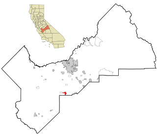
Riverdale is a census-designated place (CDP) in Fresno County, California, United States. The population was 3,153 at the 2010 census, up from 2,416 at the 2000 census. Riverdale is located 23 miles (37 km) south of Fresno, at an elevation of 223 ft (68 m).

<span class="mw-page-title-main">Winchester, California</span> Census-designated place in California, United States

Winchester is a census-designated place (CDP) in Riverside County, California, USA. As of the 2010 census, the CDP had a total population of 2,534, up from 2,155 at the 2000 census.

<span class="mw-page-title-main">Fairbanks Ranch, California</span> Census-designated place in California, United States

Fairbanks Ranch is a census-designated place (CDP) in San Diego County, California. The population was 3,148 at the 2010 census, up from 2,244 at the 2000 census. The entire population is contained within two gated communities, divided into North and South sections by the formerly private San Dieguito Road.

<span class="mw-page-title-main">Orchidlands Estates, Hawaii</span> Census-designated place in Hawaii, U.S.

Orchidlands Estates is a census-designated place (CDP) in Hawaiʻi County, Hawaiʻi, United States located in the District of Puna. The population was 2,815 at the 2010 census, up from 1,731 at the 2000 census.

<span class="mw-page-title-main">Rosedale, Maryland</span> Census-designated place in Maryland, United States

Rosedale is an unincorporated community and census-designated place in Baltimore County, Maryland, United States. The population was 19,257 at the 2010 United States Census.

<span class="mw-page-title-main">Helena Valley Northeast, Montana</span> Census-designated place in Montana, United States

Helena Valley Northeast is a census-designated place (CDP) in Lewis and Clark County, Montana, United States. The population was 2,995 at the 2010 census. It is part of the Helena Micropolitan Statistical Area.

<span class="mw-page-title-main">Woodbridge (CDP), New Jersey</span> Populated place in Middlesex County, New Jersey, US

Woodbridge is an unincorporated community and census-designated place (CDP) within Woodbridge Township, in Middlesex County, in the U.S. state of New Jersey. As of the 2010 United States Census, the CDP's population was 19,265. Despite the similarity in the name of the CDP and the township, the two are not coextensive; the CDP occupies 15.7% of the township's 24.51 square miles (63.5 km2).

<span class="mw-page-title-main">Mount Ivy, New York</span> Census-designated place in New York, United States

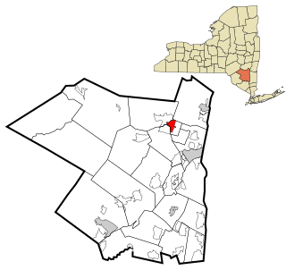
Mount Ivy is a hamlet and census-designated place in the Town of Haverstraw, in Rockland County, New York, United States. It is located north of New City, east of Pomona, south of Thiells, and west of Garnerville. The population was 6,878 at the 2010 census.

<span class="mw-page-title-main">Viola, New York</span> Census-designated place in New York, United States

Viola is a hamlet and census-designated place in the town of Ramapo, Rockland County, New York, United States. It is located north of Airmont, east of Montebello, south of Wesley Hills, and west of Hillcrest. The population was 6,868 at the 2010 census.

<span class="mw-page-title-main">East Kingston, New York</span> CDP in New York, United States

East Kingston is a hamlet in Ulster County, New York, United States. The population was 277 at the 2020 census.

<span class="mw-page-title-main">Zena, New York</span> CDP in New York, United States

Zena is a hamlet in Ulster County, New York, United States. As of the 2020 census the population was 1,038.

<span class="mw-page-title-main">Pleasant Run Farms, Ohio</span> Census-designated place in Ohio, United States

Pleasant Run Farms is a census-designated place (CDP) in Hamilton County, Ohio, United States. The population was 4,779 at the 2020 census.

<span class="mw-page-title-main">White Oak, Ohio</span> Census-designated place in Ohio, United States

White Oak is a census-designated place (CDP) in Hamilton County, Ohio, United States. It is seven miles northwest of Cincinnati. The population was 19,541 at the 2020 census. White Oak is situated in both Green Township and Colerain Township.

<span class="mw-page-title-main">Pleasant Grove, Ohio</span> CDP in Ohio, United States

Pleasant Grove is a census-designated place (CDP) in Muskingum County, Ohio, United States. The population was 2,016 at the 2000 census.

Rocky Ford is a census-designated place (CDP) in Delaware and Cherokee counties, Oklahoma, United States. The population was 61 at the 2010 census.

<span class="mw-page-title-main">West Lake Stevens, Washington</span> Former CDP in Washington, United States

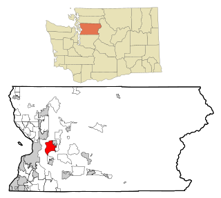
West Lake Stevens is a former census-designated place (CDP) in Snohomish County, Washington, United States. The population was 18,071 at the 2000 census.

<span class="mw-page-title-main">Kingston (CDP), Massachusetts</span> Census-designated place in Massachusetts, United States

Kingston is a census-designated place (CDP) in the town of Kingston in Plymouth County, Massachusetts, United States. The population was 5,591 at the 2010 census.

<span class="mw-page-title-main">Woodstock (CDP), New York</span> CDP in New York, United States

Woodstock is a hamlet in Ulster County, New York, United States. The population was 2,088 according to the 2010 census. The community of Woodstock is in the eastern part of the Town of Woodstock and is northwest of Kingston. It is located along NY 212 near its junction with NY 375. Although the name of the community and the town lent its name to the Woodstock Festival, that event did not take place in Woodstock.

<span class="mw-page-title-main">Barclay, New Jersey</span> Populated place in Camden County, New Jersey, US

Barclay Farm is an unincorporated community and census-designated place (CDP) located within Cherry Hill, in Camden County, in the U.S. state of New Jersey, that had been part of the Barclay-Kingston CDP until 2000, which was split to form the CDPs of Barclay and Kingston Estates as of the 2010 Census. Until the 2000 census, Barclay was included as part of the Barclay-Kingston CDP. As of the 2010 United States Census, the CDP's population was 4,428.

<span class="mw-page-title-main">Kingston Estates, New Jersey</span> Populated place in Camden County, New Jersey, US

Kingston Estates is an unincorporated community and census-designated place (CDP) located within Cherry Hill, in Camden County, in the U.S. state of New Jersey, that had been part of the Barclay-Kingston CDP until the 2000 census, which was split to form the CDPs of Barclay and Kingston Estates as of the 2010 Census. As of the 2010 United States Census, the CDP's population was 5,685.

References

  1. 1 2 U.S. Census website, United States Census Bureau. Accessed September 4, 2014.
  2. New Jersey: 2010 - Population and Housing Unit Counts - 2010 Census of Population and Housing, United States Census Bureau, August 2012. Accessed October 14, 2012. "Deleted CDPs: Barclay-Kingston (split to form Barclay and Kingston Estates CDPs)"
  3. US Gazetteer files: 2010, 2000, and 1990, United States Census Bureau. Accessed September 4, 2014.