Brooklyn is a borough of New York City. Located on the westernmost end of Long Island, it is coextensive with Kings County in the U.S. state of New York. With 2,736,074 residents as of the 2020 United States census, Kings County is the most populous of the five boroughs of New York City and the most populous county in the State of New York. The population density of Brooklyn was 37,339.9 inhabitants per square mile (14,417.0/km2) in 2022, making it the second-most-densely-populated county in the United States, behind Manhattan, and it had the ninth-highest population of any county nationwide. Were Brooklyn still an independent city, it would be the fourth most populous in the U.S. after the rest of New York City, Los Angeles, and Chicago.

South Portland is a city in Cumberland County, Maine, United States, and is the fourth-most populous city in the state, incorporated in 1898. At the 2020 census, the city population was 26,498. Known for its working waterfront, South Portland is situated on Portland Harbor and overlooks the skyline of Portland and the islands of Casco Bay. Due to South Portland's close proximity to air, marine, rail, and highway transportation options, the city has become a center for retail and industry in the region. The Maine Mall, the largest shopping mall in the state, is located in South Portland.

Briarcliff Manor is a suburban village in Westchester County, New York, 30 miles (50 km) north of New York City. It is on 5.9 square miles (15 km2) of land on the east bank of the Hudson River, geographically shared by the towns of Mount Pleasant and Ossining. Briarcliff Manor includes the communities of Scarborough and Chilmark, and is served by the Scarborough station of the Metro-North Railroad's Hudson Line. A section of the village, including buildings and homes covering 376 acres (152 ha), is part of the Scarborough Historic District and was listed on the National Register of Historic Places in 1984. The village motto is "A village between two rivers", reflecting Briarcliff Manor's location between the Hudson and Pocantico Rivers. Although the Pocantico is the primary boundary between Mount Pleasant and Ossining, since its incorporation the village has spread into Mount Pleasant.

North Yorkshire is a ceremonial county in the Yorkshire and the Humber and North East regions of England. It borders County Durham to the north, the North Sea to the east, the East Riding of Yorkshire to the south-east, South Yorkshire to the south, West Yorkshire to the south-west, and Cumbria and Lancashire to the west. Northallerton is the county town. The county was historically part of Yorkshire.

Scarborough is a seaside town in the district and county of North Yorkshire, England. With a population of 61,749, Scarborough is the largest town on the Yorkshire Coast and the fourth-largest settlement in the county.

Charles Joseph Scarborough is an American television host and former politician who is the co-host of Morning Joe on MSNBC with his wife Mika Brzezinski and Willie Geist. He previously hosted Scarborough Country on the same network. A former member of the Republican Party, Scarborough was in the United States House of Representatives for Florida's 1st district from 1995 to 2001. He was appointed to the President's Council on the 21st Century Workforce in 2002 and was a visiting fellow at the Harvard Institute of Politics at the Harvard Kennedy School of Government. He was named in the 2011 Time 100 as one of the most influential people in the world.

Branch Brook Park is a county park of Essex County, New Jersey. It is located in the North Ward of Newark, between the neighborhoods of Forest Hill and Roseville. A portion of the park is also located within the Township of Belleville. At 360 acres (150 ha), Branch Brook Park is the largest public park in the city of Newark. The park is noted for the largest collection of cherry blossom trees in the United States, having over 5,000 in more than eighteen different varieties collectively called Cherryblossomland, as well as its spectacular Cherry Blossom Festival each April.

Oakland Mills is one of the 10 villages in Columbia, Maryland, United States. It is located immediately east of Town Center, across U.S. Route 29.
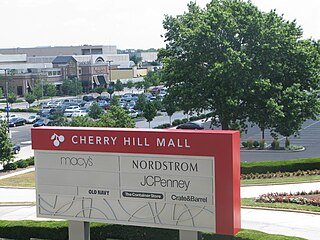
The Cherry Hill Mall is an indoor shopping center located in Cherry Hill, New Jersey, within the unincorporated namesake neighborhood and census-designated place (CDP) of Cherry Hill Mall, New Jersey.

Lindenwold station is a train station in Lindenwold, New Jersey, United States, served by the NJ Transit Atlantic City Line regional rail service and the rapid transit PATCO Speedline. Lindenwold is the eastern terminus of PATCO; the system's headquarters and maintenance facility are located adjacent to the station in neighboring Voorhees.

The King's Christian School is a private school located in Cherry Hill, in Camden County, in the U.S. state of New Jersey, that serves students in pre-kindergarten through twelfth grade. King's is owned and operated by 'The Association of The King's Christian School,' a non-profit organization governed by a board of directors and made up of the parents and friends of the school; it is not associated with any particular main-line Protestant denomination or church. The school is housed on a single campus for pre-kindergarten to 12th grade students at 5 Carnegie Plaza in Cherry Hill.
Rose Hill is a neighborhood in the New York City borough of Manhattan, between the neighborhoods of Murray Hill to the north and Gramercy Park to the south, Kips Bay to the east, the Flatiron District to the southwest, and NoMad to the northwest. The formerly unnamed area is sometimes considered to be a part of NoMad, because the name "Rose Hill" was chiefly used for the area in the 18th and 19th centuries, and is not very commonly used to refer to the area in the 2010s.

The York–Beverley line was a railway line between York, Market Weighton and Beverley in Yorkshire, England. The line was sanctioned in 1846 and the first part, the York to Market Weighton Line opened in 1847. Construction of the second part to Beverley was delayed for 17 years in part by the downfall of George Hudson, and a less favourable financial environment following the collapse of the 1840s railway bubble; the North Eastern Railway revived and completed the scheme in the 1860s; the Market Weighton to Beverley Line opened in 1865.

Brooklyn is one of the southernmost neighborhoods in Baltimore, Maryland. It is located near Anne Arundel County along Governor Ritchie Highway which is also Maryland Route 2. Its main roads are South Hanover Street,, Potee Street, and East Patapsco Avenue, Sixth Street, Tenth Street, and West Bay Avenue which borders the neighboring Curtis Bay community to the east, running through Bay Brook Park, which separates the two. South Hanover Street also serves as the dividing line between east–west streets in Brooklyn, as Charles Street does not exist here.

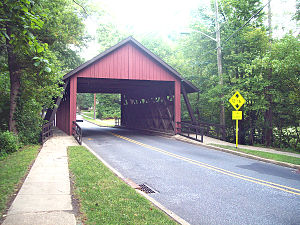
Green Sergeant's Covered Bridge is a wooden covered bridge over the Wickecheoke Creek near the border between the Hunterdon Plateau and Amwell Valley located in Delaware Township, Hunterdon County, New Jersey. As the last historic covered bridge in the state of New Jersey, it was listed on the National Register of Historic Places on November 19, 1974 for its significance in engineering and transportation. It was added as a contributing property to the Covered Bridge Historic District in 1999.
Cherry Hill is a township within Camden County, in the U.S. state of New Jersey. As a suburb of Philadelphia the township is part of South Jersey and the Delaware Valley region. Cherry Hill Township grew during the mid-20th century suburbanization, becoming one of the Delaware Valley's main commercial centers, including the Cherry Hill Mall. As of the 2020 United States census, the township's population was 74,553.

Baltimore is the most populous city in the U.S. state of Maryland. With a population of 585,708 at the 2020 census, it is the 30th-most populous city in the United States. Baltimore was designated an independent city by the Constitution of Maryland in 1851, and is currently the most populous independent city in the nation. As of the 2020 census, the population of the Baltimore metropolitan area was 2,838,327, the 20th-largest metropolitan area in the country. When combined with the larger Washington metropolitan area, the Washington–Baltimore combined statistical area (CSA) has a 2020 U.S. census population of 9,973,383, the third-largest in the country. Though the city is not located within or under the administrative jurisdiction of any county in the state, it is considered to be part of the Central Maryland region, together with the surrounding county that shares its name.
Woodcrest is a neighborhood located within Cherry Hill in Camden County, in the U.S. state of New Jersey. The area dates back to the 1950s and is one of the oldest neighborhoods in Cherry Hill. It was developed by Morris and Harold Sarshik.

Barclay Farm is an unincorporated community and census-designated place (CDP) located within Cherry Hill, in Camden County, in the U.S. state of New Jersey, that had been part of the Barclay-Kingston CDP until 2000, which was split to form the CDPs of Barclay and Kingston Estates as of the 2010 Census. Until the 2000 census, Barclay was included as part of the Barclay-Kingston CDP. As of the 2010 United States Census, the CDP's population was 4,428.