The Kamay Botany Bay National Park is a heritage-listed protected national park that is located in the Sydney metropolitan region of New South Wales, in eastern Australia. The 456-hectare (1,130-acre) national park is situated approximately 16 kilometres (9.9 mi) south-east of the Sydney central business district, on the northern and southern headlands of Botany Bay. The northern headland is at La Perouse and the southern headland is at Kurnell.

Ku-ring-gai Chase National Park is a national park on the northern side of Sydney in New South Wales, Australia. The 14,977-hectare (37,010-acre) park is 25 kilometres (16 mi) north of the Sydney central business district and generally comprises the land east of the M1 Pacific Motorway, south of the Hawkesbury River, west of Pittwater and north of Mona Vale Road. It includes Barrenjoey Headland on the eastern side of Pittwater.

The Royal National Park is a protected national park that is located in Sutherland Shire in the Australian state of New South Wales, just south of Sydney.

Palm Beach is a suburb in the Northern Beaches region of Sydney, in the state of New South Wales, Australia. Palm Beach is located 41 kilometres (25 mi) north of the Sydney central business district, in the local government area of Northern Beaches Council. Palm Beach sits on a peninsula at the end of Barrenjoey Road, between Pittwater and Broken Bay. The population of Palm Beach was 1,593 as at the 2016 census.

Broken Bay, a semi-mature tide-dominated drowned valley estuary, is a large inlet of the Tasman Sea located about 50 kilometres (31 mi) north of Sydney central business district on the coast of New South Wales, Australia; being one of the bodies of water that separate greater Metropolitan Sydney from the Central Coast. Broken Bay is the first major bay north of Sydney Harbour.
The Hawkesbury River, or Hawkesbury-Nepean River, is a river located northwest of Sydney, New South Wales, Australia. The Hawkesbury River and its associated main tributary, the Nepean River, almost encircle the metropolitan region of Sydney.

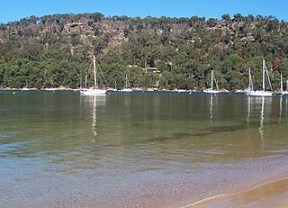
Pittwater is a semi-mature tide dominated drowned valley estuary, located about 40 kilometres (25 mi) north of the Sydney central business district, New South Wales, Australia; being one of the bodies of water that separate greater Metropolitan Sydney from the Central Coast.
Beecroft Peninsula is the northern headland of Jervis Bay, on Australia's east coast. On the western and southern sides of the peninsula steep sandstone cliffs rise out of the ocean, up to 91 metres at its southernmost point, Point Perpendicular. White sandy beaches are found along the northern, eastern and southern sides interspersed with numerous intertidal reefs.
Coasters Retreat is an offshore suburb in northern Sydney, in the state of New South Wales, Australia, 42 kilometres north of the Sydney central business district, in the local government area of Northern Beaches Council.
Umina Beach is a suburb within the Central Coast Council local government area on the Central Coast of New South Wales, Australia. By road, it is 85 kilometres (53 mi) north of the Sydney CBD and 111 kilometres (69 mi) south of the Newcastle CBD.

Lion Island is a river island that is located at the mouth to the Hawkesbury River inside Broken Bay, in the state of New South Wales, Australia. The island is considered part of the Central Coast Council. It is a descriptive name because it resembles a Sphinx, a mythical figure of a crouching lion.

The geography of Sydney is characterised by its coastal location on a basin bordered by the Pacific Ocean to the east, the Blue Mountains to the west, the Hawkesbury River to the north and the Woronora Plateau to the south. Sydney lies on a submergent coastline on the east coast of New South Wales, where the ocean level has risen to flood deep river valleys (rias) carved in the Sydney sandstone. Port Jackson, better known as Sydney Harbour, is one such ria.

Great Mackerel Beach is a suburb about 43 kilometres north of the Sydney central business district, from 2016 in the local government area of Northern Beaches Council, Sydney, New South Wales, Australia, formerly part of Pittwater Council. It is on the western shores of Pittwater in Ku-ring-gai Chase National Park, beside Currawong Beach, and near Coasters Retreat and Palm Beach.The resident population was 50 at the 2021 census; the median age was 57, with an average of 0.3 children per family and an average of 1.7 people per household. The population was 36 at the 2016 census, 301 at the 2011 census, and 103 in 2006. As of 2021 there were 111 private dwellings, with many people not listed as residents occupying properties during school holidays and weekends.

The Eastern Australian temperate forests is a broad ecoregion of open forest on uplands starting from the east coast of New South Wales in the South Coast to southern Queensland, Australia. Although dry sclerophyll and wet sclerophyll eucalyptus forests predominate within this ecoregion, a number of distinguishable rainforest communities are present as well.

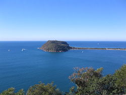
The Barrenjoey Head Lighthouse is a heritage-listed lighthouse at Barrenjoey Headland, Palm Beach, Northern Beaches Council, New South Wales, Australia. It was designed by James Barnet, the New South Wales Colonial Architect and built by Isaac Banks. It is also known as Barrenjoey Head Lightstation. The property is owned by Office of Environment and Heritage, an agency of the Government of New South Wales. The lightstation was added to the New South Wales State Heritage Register on 2 April 1999.

The Littoral Rainforests of New South Wales is a group of fragmented and endangered ecological communities found by the coast in eastern Australia. Much of this seaside form has been destroyed by mining, tourist development or housing. It is threatened by extinction in the near future. 90% of the 433 sites are less than ten hectares in size. Littoral rainforest amounts to 0.6% of the rainforests in New South Wales.

McKay Reserve is a small tract of remnant urban bushland in Palm Beach, parts of which contain the endangered ecological community (EEC) Pittwater and Wagstaffe Spotted Gum Forest. The reserve lies on a ridge on the Barrenjoey Peninsula and overlooks western Pittwater.

The Sydney Sandstone Ridgetop Woodland, also known as Coastal Sandstone Ridgetop Woodland and Hornsby Enriched Sandstone Exposed Woodland, is a shrubby woodland and mallee community situated in northern parts of Sydney, Australia, where it is found predominantly on ridgetops and slopes of the Hornsby Plateau, Woronora Plateau and the lower Blue Mountains area. It is an area of high biodiversity, existing on poor sandstone soils, with regular wildfires, and moderate rainfall.

The ecology of Sydney, located in the state of New South Wales, Australia, is diverse for its size, where it would mainly feature biomes such as grassy woodlands or savannas and some sclerophyll forests, with some pockets of mallee shrublands, riparian forests, heathlands, and wetlands, in addition to small temperate rainforest fragments.

Limeburners Creek National Park is a protected national park on the Mid North Coast of New South Wales, Australia. The 91.2 km national park is located 5 km (3.1 mi) to the north of Port Macquarie and exists across both the Kempsey Shire and Port Macquarie-Hastings Council local government areas, but is chiefly managed by National Parks and Wildlife Service. The area was originally erected as a nature reserve but this reservation was revoked when it became formally recognised as a national park in 2010 under the National Parks and Wildlife Act (1974). Many threatened ecological habitats and species of fauna and flora are found within this park, alongside several heritage sites of cultural significance, particularly to the local Birpai and Dunghutti people upon whose land the park exists. The protected status of this national park is largely owing to the ecological and cultural value of the area, in addition to the value of the ecosystems to further scientific research.