
Barrow-in-Furness is a port town and civil parish in the Westmorland and Furness district of Cumbria, England. Historically in Lancashire, it was incorporated as a municipal borough in 1867 and merged with Dalton-in-Furness Urban District in 1974 to form the Borough of Barrow-in-Furness. The borough was merged into the new Westmorland and Furness district in 2023. At the tip of the Furness peninsula, close to the Lake District, it is bordered by Morecambe Bay, the Duddon Estuary and the Irish Sea. In 2021, Barrow's population was 55,489, making it the second largest urban area in Cumbria after Carlisle, and the largest in the Westmorland and Furness unitary authority.

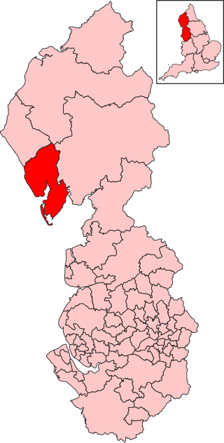
Barrow-in-Furness was a local government district with borough status in Cumbria, England. It was named after its main town, Barrow-in-Furness. Other settlements included Dalton-in-Furness and Askam-in-Furness. It was the smallest district in Cumbria, but the most densely populated, with 924 people per square kilometre. The population was 71,980 in 2001, reducing to 69,087 at the 2011 Census.
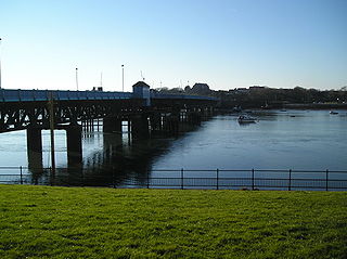
Walney Island, also known as the Isle of Walney, is an island off the west coast of England, at the western end of Morecambe Bay in the Irish Sea. Within the boundaries of the historic county of Lancashire, it is part of Barrow-in-Furness, separated from the mainland by Walney Channel, which is spanned by the Jubilee Bridge. Walney is the largest island of the Furness Islands group, both in population and size, as well as the largest English island in the Irish Sea. Its population at the 2011 UK Census was 10,651, distributed evenly across the island's two Wards of Walney North and Walney South.
Barrow and Furness, formerly known as Barrow-in-Furness, is a UK Parliament constituency in Cumbria. It has been represented in the House of Commons of the UK Parliament by Michelle Scrogham of the Labour Party since 2024.

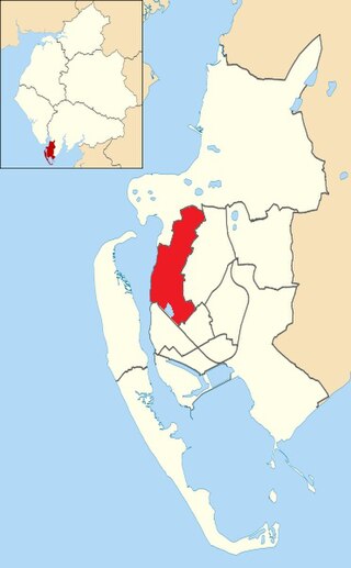
Barrow Island is an area and former electoral ward of Westmorland and Furness, Cumbria, England. Originally separate from the British mainland, land reclamation in the 1860s saw the northern fringes of the island connected to Central Barrow. Barrow Island is also bound to the south and east by the town's dock system and to the west by Walney Channel. The Ward population taken at the 2011 census was 2,616.
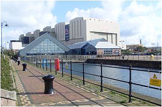
The Dock Museum is situated in Barrow-in-Furness, Cumbria, England. Most of its exhibits concern the history of the town, focusing on the shipbuilding industry at VSEL, the steelworks industry — of which Barrow once had the world's largest, the Furness Railway and the World War II bombings of the town. There has been a museum in Barrow since 1907 and in its current location since 1994, when 50,000 people visited it in its first year, visitor numbers peaked at 120,000 in 2001. The museum has free entry and remains under public ownership.
Hawcoat is an area and electoral ward of Barrow-in-Furness, Cumbria, England. Historically part of Lancashire, it is one of Barrow's most northerly wards and is bordered by Roose, Newbarns, Parkside, Ormsgill and the town of Dalton-in-Furness to the north.
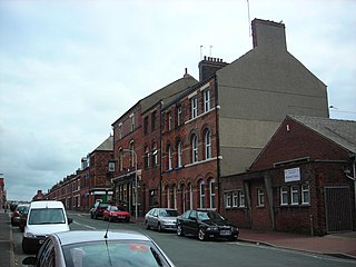
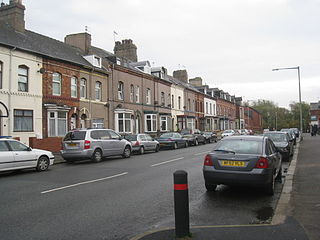
Hindpool is an area and electoral ward of Barrow-in-Furness, Cumbria, England. It is bordered by Barrow Island, Central Barrow, Ormsgill, Parkside and the Walney Channel, the local population stood at 5,851 in 2011. The ward covers the entire western half of the town centre and includes Barrow's main shopping district. Other local landmarks include the Furness College Channelside campus, the Dock Museum and the Main Public Library. Hindpool is also home to two stadia - Barrow Raiders' Craven Park and Barrow A.F.C.'s Holker Street.
Ormsgill is an area and ward of Barrow-in-Furness, Cumbria, England. It is bordered by Hindpool, Parkside, Hawcoat, Roanhead and Walney Channel. The population of the ward in 2001 stood at 5,961 ,increasing to 6,033 at the 2011 Census. Almost three quarters of Ormsgill is greenspace, with the majority of residents living in the densely populated south-east corridor. The western part of the ward is predominantly industrial and includes a large Kimberly-Clark plant and numerous other industrial estates which provide a base for companies including Blyth, BT, Gyrodata, McBride and Oil States International.

The Port of Barrow refers to the enclosed dock system within the town of Barrow-in-Furness, England. Morecambe Bay is to the east of the port and the Irish Sea surrounds it to the south and west. The port is currently owned and operated by Associated British Ports Holdings, but some land is shared with BAE Systems Submarine Solutions. Currently consisting of four large docks, the Port of Barrow is one of North West England's most important ports. The docks are as follows: Buccleuch Dock, Cavendish Dock, Devonshire Dock and Ramsden Dock. The port of Barrow is the only deep water port between the Mersey and the Clyde.
Parkside is an area and former electoral ward of Barrow-in-Furness, Cumbria, England. It is bordered by Hindpool, Ormsgill, Hawcoat, Newbarns and Risedale and had a population of 5,742 in 2001, reducing to 5,584 at the 2011 Census. It is one of the town's most centralised wards and contains Barrow's main park, as well as the newly established Furness Academy.
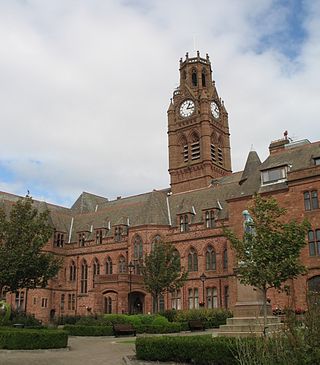
Barrow-in-Furness Town Hall is a Gothic Revival style municipal building in Barrow-in-Furness, Cumbria, England. The building, which served as the headquarters of the former Barrow Borough Council, and now one of the bases of Westmorland and Furness Council, lies within a Conservation Area with Grade II* listed status.

The Waterfront Barrow-in-Furness is a £200 million development under construction in and around the Port of Barrow, England. The site covers an area of some 400 acres (160 ha) and was due for completion in 2020. The internal road network is already complete, with construction of a large business park complex ongoing and work on a 400-berth marina and 650 home Marina Village due to start thereafter. In 2010, The Waterfront Barrow-in-Furness ranked as the ninetieth most costly regeneration project in the United Kingdom by Regeneration & Renewal. Progress on the project stalled between 2010 and 2016 due to complications with funding following the disabandonment of the North West Regional Development Agency. BAE Systems opened a large logistics warehouse named the Resolution Building on Dova Way within the designated Business Park Area in October 2016, while and construction of a new access road from Salthouse Road to the Marina Village commenced in May 2017.

The National Westminster Bank building in Barrow-in-Furness, Cumbria, England is located at the intersection of Abbey Road and Duke Street. It was designed by Paley and Austin architects and built between 1873–74 and has been designated a Grade II listed building by English Heritage. Built for the Lancaster branch of the National Westminster Bank it was a major component of the Ramsden Square scheme, one of the planned town's two main squares and focal points. It is one of three former 'Nat West' properties with listed building status in the Borough and currently houses a carpet shop in the lower floors.

Abbot's Wood was a large country house and estate located to the north-northeast of Barrow-in-Furness, Cumbria, England. It was sited on elevated ground to the northeast of Furness Abbey. The house was surrounded by extensive grounds with footpaths providing fine views.
The following is a timeline of the history of Barrow-in-Furness, England, United Kingdom.
Thorncliffe Cemetery and Crematorium is a 66-acre graveyard located on Devonshire Road in the Ormsgill ward of Barrow-in-Furness, Cumbria, England.
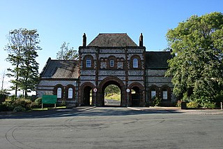
Ramsden Dock railway station was the terminus of the Furness Railway's Ramsden Dock Branch in Barrow-in-Furness, England.
