
Barrow-in-Furness is a port town and civil parish in the Westmorland and Furness district, in the ceremonial county of Cumbria, England. Historically in Lancashire, it was incorporated as a municipal borough in 1867 and merged with Dalton-in-Furness Urban District in 1974 to form the Borough of Barrow-in-Furness. In 2023, the borough merged with Eden and South Lakeland districts to form a new unitary authority: Westmorland and Furness. At the tip of the Furness peninsula, close to the Lake District, it is bordered by Morecambe Bay, the Duddon Estuary and the Irish Sea. In 2021, Barrow's population was 55,489, making it the second largest urban area in Cumbria after Carlisle, and the largest in the Westmorland and Furness unitary authority.

Furness is a peninsula and region of Cumbria, England. Together with the Cartmel Peninsula it forms North Lonsdale, historically an exclave of Lancashire. On 1 April 2023 it became part of the new unitary authority of Westmorland and Furness.
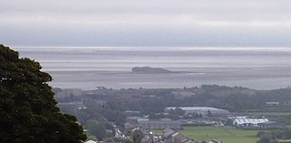
The Islands of Furness are situated to the south-west and east of the Furness Peninsula. Within England, they are the third biggest collection of islands. They are generally quite small, though at 12.99 km2 Walney Island is the eighth biggest in England. Of these, only Walney Island, Barrow Island, Roa Island and Piel Island are inhabited. The majority of the islands lay within the boundary of the former Borough of Barrow-in-Furness, with some 15,000 residents constituting 20% of the district's population. They are the largest group of islands between Anglesey in Wales and the Firth of Clyde in Scotland.
Walney Island, also known as the Isle of Walney, is an island off the west coast of England, at the western end of Morecambe Bay in the Irish Sea. Within the boundaries of the historic county of Lancashire, it is part of Barrow-in-Furness, separated from the mainland by Walney Channel, which is spanned by the Jubilee Bridge. Walney is the largest island of the Furness Islands group, both in population and size, as well as the largest English island in the Irish Sea. Its population at the 2011 UK Census was 10,651, distributed evenly across the island's two Wards of Walney North and Walney South.
Vickerstown is an area of Barrow-in-Furness, Cumbria, England, covered by the wards of Walney North and Walney South. It is an example of a model village built for workers by a company needing to expand, having been constructed in the early 20th century by Vickers Shipbuilding and Engineering. Vickerstown contains two Conservation Areas and is home to the majority of the population of Walney Island.

BAE Systems Submarines, is a wholly owned subsidiary of BAE Systems, based in Barrow-in-Furness, Cumbria, England, and is responsible for the development and production of submarines.

Walney Aerodrome is located on Walney Island, 1.5 NM northwest of the centre of Barrow-in-Furness, Cumbria, England. The airport is owned by BAE Systems, who operate private communication flights to locations across the United Kingdom and expanded the airport with new infrastructure and terminal buildings in 2019.
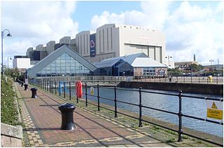
The Dock Museum is situated in Barrow-in-Furness, Cumbria, England. Most of its exhibits concern the history of the town, focusing on the shipbuilding industry at VSEL, the steelworks industry — of which Barrow once had the world's largest, the Furness Railway and the World War II bombings of the town. There has been a museum in Barrow since 1907 and in its current location since 1994, when 50,000 people visited it in its first year, visitor numbers peaked at 120,000 in 2001. The museum has free entry and remains under public ownership.

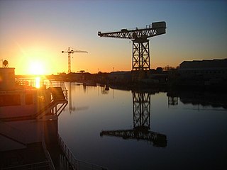
Devonshire Dock Hall is a large indoor shipbuilding and assembly complex that forms part of the BAE Systems shipyard in the Barrow Island area of Barrow-in-Furness, Cumbria, England.
Hindpool is an area and electoral ward of Barrow-in-Furness, Cumbria, England. It is bordered by Barrow Island, Central Barrow, Ormsgill, Parkside and the Walney Channel, the local population stood at 5,851 in 2011. The ward covers the entire western half of the town centre and includes Barrow's main shopping district. Other local landmarks include the Furness College Channelside campus, the Dock Museum and the Main Public Library. Hindpool is also home to two stadia - Barrow Raiders' Craven Park and Barrow A.F.C.'s Holker Street.

The Port of Barrow refers to the enclosed dock system within the town of Barrow-in-Furness, England. Morecambe Bay is to the east of the port and the Irish Sea surrounds it to the south and west. The port is currently owned and operated by Associated British Ports Holdings, but some land is shared with BAE Systems Submarine Solutions. Currently consisting of four large docks, the Port of Barrow is one of North West England's most important ports. The docks are as follows: Buccleuch Dock, Cavendish Dock, Devonshire Dock and Ramsden Dock. The port of Barrow is the only deep water port between the Mersey and the Clyde.

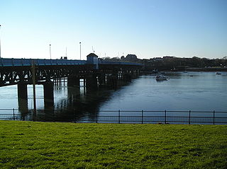
Michaelson Road Bridge is a road bridge connecting Central Barrow to Barrow Island in south Cumbria, England. The original high-level bridge was a swing bridge and then replaced by a pair of lift and roll bridges constructed between 1800 and 1884 then superseded by a more modern pair of bascule bridges in the mid 1960s. It was built at a time when Barrow Island was actually an island and there was strong call for road access between mainland Barrow at the shipyard on Barrow Island. Traffic on the bridge was soon relieved when an old Victorian dock was filled in and space was created for the huge Devonshire Dock Hall complex, traffic now runs along the north side of the building on the A590.
Buccleuch Dock is one of the four docks which make up the Port of Barrow in Barrow-in-Furness, England. It was constructed between 1863 and 1872 to the same specification as the attached Devonshire Dock - the docks having been separated by a bridge for most of their lifetime. Buccleuch Dock covers 125,000 square metres (1,350,000 sq ft) and was named after the 5th Duke of Buccleuch, who invested heavily in Barrow's public services during the late 19th century. Buccleuch Dock is owned by Associated British Ports and is also used by BAE Systems where the majority of the shipyard's surface vessels are docked for fitting out.

Devonshire Dock is the oldest of the four docks which make up the Port of Barrow in Barrow-in-Furness, England. Although the dock falls under the control of Associated British Ports it is currently solely utilised by BAE Systems. Upon completion of the dock, Prime Minister William Ewart Gladstone stated 'Barrow would one day become another Liverpool'. Although its shipbuilding capabilities have exceeded those on Merseyside, the port and dock system itself never fully met James Ramsden's grand vision for the town.

The Waterfront Barrow-in-Furness is a £200 million development under construction in and around the Port of Barrow, England. The site covers an area of some 400 acres (160 ha) and was due for completion in 2020. The internal road network is already complete, with construction of a large business park complex ongoing and work on a 400-berth marina and 650 home Marina Village due to start thereafter. In 2010, The Waterfront Barrow-in-Furness ranked as the ninetieth most costly regeneration project in the United Kingdom by Regeneration & Renewal. Progress on the project stalled between 2010 and 2016 due to complications with funding following the disabandonment of the North West Regional Development Agency. BAE Systems opened a large logistics warehouse named the Resolution Building on Dova Way within the designated Business Park Area in October 2016, while and construction of a new access road from Salthouse Road to the Marina Village commenced in May 2017.

The Barrow Hematite Steel Company Limited was a major iron and steel producer based in Barrow-in-Furness, Lancashire, England, between 1859 and 1963. At the turn of the 20th century and the Technological Revolution it operated the largest steel mill in the world.

The Devonshire Buildings are two adjacent apartment buildings in the Barrow Island area of Barrow-in-Furness, Cumbria, England. They are both recorded in the National Heritage List for England as designated Grade II* listed buildings.

The VSEL Heavy Engineering Workshop located at Michaelson Road in the Barrow Island area of Barrow-in-Furness, Cumbria, England is a Grade II listed former ammunitions workshop that belonged to Vickers Shipbuilding and Engineering. Known locally as the 'Gun Shop' the vast complex was constructed in stages between 1875 and 1900 and consists of 42 by 11 bays. The building was a major component of the engineering division within Vickers and supplied the British Army and Royal Navy throughout World War I and World War II. Everything from basic shells to heavy duty gun turrets for ships, tanks and other land vehicles were produced and assembled at the workshop. The Historic England states the following of the building: 'It clearly indicates the scale of operation of the shipbuilding and engineering works at the turn of the century; its roadside frontages make a major contribution to the industrial scene in a town where the buildings of other major C19 industries have been almost completely swept away.'
The following is a timeline of the history of Barrow-in-Furness, England, United Kingdom.
The Scotch Buildings was a large complex of tenement housing located off Duke Street in Barrow-in-Furness, then Lancashire, United Kingdom. The build was commissioned by the Barrow Hematite Steel Company and constructed somewhat hastily by Scottish firm Smith and Caird between 1871 and 1872 to address a chronic housing shortage in the rapidly expanding town. The complex took on a triangular form with a centrally located courtyard. The four storey building was constructed from the iconic Hawcoat sandstone and was bound by Blake Street, Duke Street and Walney Road. Two shops and a working men's club were sited on the three corners of the building. It contained some 260 flats housing over 1,000 residents. The Scotch Buildings were ultimately demolished in 1956, the entire site is now shared by a Travis Perkins outlet and the Former Agrilek Engineering company office, now Saint Mary's Hospice Furniture Warehouse.


