Related Research Articles

Barrow-in-Furness is a local government district with borough status in Cumbria, England. It is named after its main town, Barrow-in-Furness. Other settlements include Dalton-in-Furness and Askam-in-Furness. It is the smallest district in the county, but is the most densely populated, with 924 people per square kilometre. The population was 71,980 in 2001, reducing to 69,087 at the 2011 Census.

Furness is a peninsula and region of Cumbria in northwestern England. Together with the Cartmel Peninsula it forms North Lonsdale, historically an exclave of Lancashire.
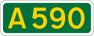
The A590 is a trunk road in southern Cumbria, in the north-west of England. It runs north-east to south-west from M6 junction 36, through the towns of Ulverston and Barrow-in-Furness to terminate at Biggar Bank on Walney Island. The road is a mixture of dual carriageway and single carriageway, with the section east of Low Newton, Cumbria to the M6 being mainly dual. Further dual sections are south of Newby Bridge, south of Greenodd and south of Ulverston. The road is the main route for tourists entering the southern Lake District. It has often humorously been described as "the longest cul-de-sac in the world".

Barrow and Furness, formerly known as Barrow-in-Furness, is a constituency in Cumbria which has been represented in the House of Commons of the UK Parliament by Conservative Simon Fell since 2019.
Barrow-in-Furness Borough Council in Cumbria, England is elected every 4 years. This was changed in 2011 from the previous situation where one third of the council was elected each year, followed by one year where there was an election to Cumbria County Council instead.
North Lonsdale was a rural district in the county of Lancashire, England from 1894 to 1974. It was created in 1894 as the Ulverston Rural District, and was renamed in 1960.
Furness Building Society is a British building society, which has its headquarters in Barrow-in-Furness, Cumbria, England. Established in 1865, it is the 17th largest in the United Kingdom based on total assets of £813 million as at 31 December 2010. It is a member of the Building Societies Association.

Hawcoat is an area and electoral ward of Barrow-in-Furness, Cumbria, England. Historically part of Lancashire, it is one of Barrow's most northerly wards and is bordered by Roose, Newbarns, Parkside, Ormsgill and the town of Dalton-in-Furness to the north.

Central Barrow refers both to the town centre of Barrow-in-Furness, Cumbria, England and to the electoral ward that roughly covers the eastern part of that town centre. In 2001 5,584 lived in the Central ward. The population density was 55.96 per hectare, which was well above the local average of 9.24, and England average, 3.77. The population of Central ward had reduced to 4,583 at the 2011 Census. Central Barrow is amongst the 3% most deprived areas in the country and households have an average weekly income around £100 lower than the region's average, however the area being the central business district of the town is also home to many of Barrow's retail outlets, as well as a large amount of offices, restaurants and governmental buildings. Part of the £200 million Waterfront Barrow-in-Furness project is being constructed in the southern part of Central Barrow.
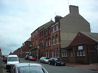
Hindpool is an area and electoral ward of Barrow-in-Furness, Cumbria, England. It is bordered by Barrow Island, Central Barrow, Ormsgill, Parkside and the Walney Channel, the local population stood at 5,851 in 2011. The ward covers the entire western half of the town centre and includes Barrow's main shopping district. Other local landmarks include the Furness College Channelside campus, the Dock Museum and the Main Public Library. Hindpool is also home to two stadia - Barrow Raiders' Craven Park and Barrow A.F.C.'s Holker Street.

Newbarns is an area and electoral ward of Barrow-in-Furness, Cumbria, England. It is bordered by Hawcoat, Parkside, Risedale and Roose, the local population stood at 5,515 in 2001, decreasing to 5,487 at the 2011 Census. Newbarns covers an area of 2.78 square kilometres and lies east of Abbey Road, encompassing Furness Abbey in its entirety, Barrow Sixth Form College and St. Bernard's Catholic High School. Newbarns is extremely diverse, with the majority of the south of the ward being amongst the 6% to 10% most deprived areas of the country, while north Newbarns contains Croslands Park, Barrow's most expensive street and is within the 25% of least deprived areas nationwide.

Abbey Road is the principal north to south arterial road through Barrow-in-Furness, Cumbria, England.
Dalton South is a ward of the British town Dalton-in-Furness, within the Borough of Barrow-in-Furness. With 6,200 people residing in Dalton South in 2001, increasing marginally to 6,207 at the 2011 Census,.
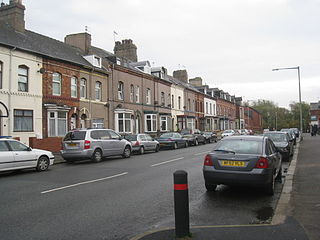
Parkside is an area and electoral ward of Barrow-in-Furness, Cumbria, England. It is bordered by Hindpool, Ormsgill, Hawcoat, Newbarns and Risedale and had a population of 5,742 in 2001, reducing to 5,584 at the 2011 Census. It is one of the town's most centralised wards and contains Barrow's main park, as well as the newly established Furness Academy. Abbey Road - Barrow's principal road runs down the entire western side of Parkside. The majority of housing to the west of Abbey Road is terraced and semi-detached, whilst the eastern side of Parkside is predominantly parkland and fields with the exception of some semi and detached housing. There are a number of place of worship in Parkside including Abbey Road Baptist Church, Spring Mount Christian Fellowship and Trinity Church Centre. Barrow's first synagogue was founded in 1902 on Abbey Road although it closed less than twenty years later.

Walney North is one of two wards on Walney Island in the Borough of Barrow-in-Furness, North West England. The 2001 UK census showed 5,604 people were living in the area, reducing to 5,304 at the 2011 Census.

Walney South is one of two wards on Walney Island in the Borough of Barrow-in-Furness, North West England. The 2001 UK census showed 5,784 people were living in the area, reducing to 5,307 at the 2011 Census. There are two main settlements within the ward: Biggar and Vickerstown. Walney Bridge connects Walney South and, in fact, the whole island to mainland Barrow.

Risedale is a ward of Barrow-in-Furness, Cumbria, England. It is bordered by Barrow town centre, Parkside, Newbarns and Roose and had a population of 5,663 in 2001,increasing to 6,294 at the 2011 Census.
Furness Academy is a secondary school in Barrow-in-Furness, England. It is the fourth academy to have been formed in the county of Cumbria after the closure of Alfred Barrow School, Parkview Community College of Technology and Thorncliffe School in 2009. Having utilised numerous buildings of the former Parkview and Thorncliffe Schools since 2009, a single £22 million building opened in the Parkside area of the town in September 2013.
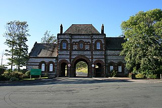
Furness Abbey is a former railway station in the Barrow-in-Furness area of the Furness Peninsula, England.
Thorncliffe Cemetery and Crematorium is a 66-acre graveyard located on Devonshire Road in the Ormsgill ward of Barrow-in-Furness, Cumbria, England.
References
- ↑ "Barrow-in-Furness ward population 2011" . Retrieved 25 January 2016.