
Barrow-in-Furness is a town in Cumbria, North-West England. Historically part of Lancashire, it was incorporated as a municipal borough in 1867 and merged with Dalton-in-Furness Urban District in 1974 to form the Borough of Barrow-in-Furness. At the tip of the Furness peninsula, close to the Lake District, it is bordered by Morecambe Bay, the Duddon Estuary and the Irish Sea. In 2011, Barrow's population was 57,000, making it the second largest urban area in Cumbria after Carlisle. Natives of Barrow, as well as the local dialect, are known as Barrovian.

East Barnet is an area of north London within the London Borough of Barnet bordered by New Barnet, Cockfosters and Southgate. It is a largely residential suburb whose central area contains shops, public houses, restaurants and services, and the parish church of St Mary the Virgin. East Barnet is close to the M25 and the A1 and M1.

Barrow-in-Furness is a local government district with borough status in Cumbria, England. It is named after its main town, Barrow-in-Furness. Other settlements include Dalton-in-Furness and Askam-in-Furness. It is the smallest district in the county, but is the most densely populated, with 924 people per square kilometre. The population was 71,980 in 2001, reducing to 69,087 at the 2011 Census.

Roose or Roosecote is a suburb and ward of Barrow-in-Furness, Cumbria, England. The word 'roose' is Celtic for "moor" or "heath" and the suffix 'cote' of Roosecote means "hut" or "huts". Before the building of Roose Cottages and the arrival of the Cornish miners Roose was pronounced with a hard S, as in goose; now it is locally pronounced 'Rooze', due to the Cornish accent. Roose is served by Roose railway station, one of the few remaining stations on the Furness Line in the Barrow area.

Barrow Island is an area and electoral ward of Barrow-in-Furness, Cumbria, England. Originally separate from the British mainland, land reclamation in the 1860s saw the northern fringes of the island connect to Central Barrow. Barrow Island is also bound to the south and east by the town's dock system and to the west by Walney Channel. The Ward population taken at the 2011 census was 2,616.

Lindal-in-Furness is a village on the Furness peninsula of Cumbria, England. Historically in Lancashire, it lies eight miles to the north-east of Barrow-in-Furness, on the A590 trunk road. The civil parish is Lindal and Marton which had a population of 755 at the 2011 Census.

Hawcoat is an area and electoral ward of Barrow-in-Furness, Cumbria, England. Historically part of Lancashire, it is one of Barrow's most northerly wards and is bordered by Roose, Newbarns, Parkside, Ormsgill and the town of Dalton-in-Furness to the north.

Central Barrow refers both to the town centre of Barrow-in-Furness, Cumbria, England and to the electoral ward that roughly covers the eastern part of that town centre. In 2001 5,584 lived in the Central ward. The population density was 55.96 per hectare, which was well above the local average of 9.24, and England average, 3.77. The population of Central ward had reduced to 4,583 at the 2011 Census. Central Barrow is amongst the 3% most deprived areas in the country and households have an average weekly income around £100 lower than the region's average, however the area being the central business district of the town is also home to many of Barrow's retail outlets, as well as a large amount of offices, restaurants and governmental buildings. Part of the £200 million Waterfront Barrow-in-Furness project is being constructed in the southern part of Central Barrow.

Askam and Ireleth is a civil parish close to Barrow-in-Furness in the county of Cumbria, in North West England. Historically part of Lancashire, it originally consisted of two separate coastal villages with different origins and histories which, in recent times, have merged to become one continuous settlement. In the 2001 census the parish had a population of 3,632, reducing at the 2011 census to 3,462.

Ulceby with Fordington is a civil parish in the East Lindsey district of Lincolnshire, England. The parish is situated 27 miles (43 km) east from the city and county town of Lincoln and 3 miles (5 km) south-west from Alford. The A1028 road runs through the parish.
Hindpool is an area and electoral ward of Barrow-in-Furness, Cumbria, England. It is bordered by Barrow Island, Central Barrow, Ormsgill, Parkside and the Walney Channel, the local population stood at 5,851 in 2011. The ward covers the entire western half of the town centre and includes Barrow's main shopping district. Other local landmarks include the Furness College Channelside campus, the Dock Museum and the Main Public Library. Hindpool is also home to two stadia - Barrow Raiders' Craven Park and Barrow A.F.C.'s Holker Street.

Ormsgill is a ward of Barrow-in-Furness, Cumbria, England. It is bordered by Hindpool, Parkside, Hawcoat, Roanhead and Walney Channel. The population of the ward in 2001 stood at 5,961 ,increasing to 6,033 at the 2011 Census. Almost three quarters of Ormsgill is greenspace, with the majority of residents living in the densely populated south-east corridor. The western part of the ward is predominantly industrial and includes a large Kimberly-Clark plant and numerous other industrial estates which provide a base for companies including Blyth, BT, Gyrodata, McBride and Oil States International.

Newbarns is an area and electoral ward of Barrow-in-Furness, Cumbria, England. It is bordered by Hawcoat, Parkside, Risedale and Roose, the local population stood at 5,515 in 2001, decreasing to 5,487 at the 2011 Census. Newbarns covers an area of 2.78 square kilometres and lies east of Abbey Road, encompassing Furness Abbey in its entirety, Barrow Sixth Form College and St. Bernard's Catholic High School. Newbarns is extremely diverse, with the majority of the south of the ward being amongst the 6% to 10% most deprived areas of the country, while north Newbarns contains Croslands Park, Barrow's most expensive street and is within the 25% of least deprived areas nationwide.

Cliburn is a village and civil parish in the Eden district of Cumbria, England. The civil parish includes the hamlet of Town Head. In 2001 the population was 204, increasing to 274 at the 2011 Census.

Risedale is a ward of Barrow-in-Furness, Cumbria, England. It is bordered by Barrow town centre, Parkside, Newbarns and Roose and had a population of 5,663 in 2001,increasing to 6,294 at the 2011 Census.

Furness Academy is a secondary school in Barrow-in-Furness, England. It is the fourth and last academy to have been formed in the county of Cumbria after the closure of Alfred Barrow School, Parkview Community College of Technology and Thorncliffe School in 2009. Having utilised numerous buildings of the former Parkview and Thorncliffe Schools since 2009, a single £22 million building opened in the Parkside area of the town in September 2013.

Haile is a small village and civil parish in Copeland district, in the county of Cumbria, England. It had a population of 617 at the 2011 Census.
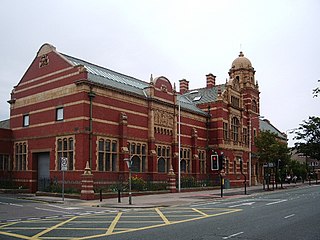
The Nan Tait Centre is a Grade II listed building located at Abbey Road in the Hindpool area of Barrow-in-Furness, Cumbria, England.

Staveley-in-Cartmel is a small village and civil parish in South Lakeland district, Cumbria, England. It lies east of Newby Bridge, near the south end of Windermere, 9 miles (14 km) northeast of Ulverston. It is sometimes known as Staveley-in-Furness. Both names distinguish it from another Staveley in Cumbria. In the 2001 census the parish had a population of 428, decreasing at the 2011 census to 405.
 Parkside shown within Barrow-in-Furness