Barva (canton)

Last updated
Barva
Templo Catolico y Barvak.JPG
Bandera de Barva (Costa Rica).svg
Escudo de Barva-Heredia.svg
Barva (canton)
Barva canton
Costa Rica location map.svg
Red pog.svg
Barva
Barva canton location in Costa Rica
Coordinates: 10°04′35″N84°06′56″W / 10.0763757°N 84.115545°W / 10.0763757; -84.115545
Country Flag of Costa Rica.svg  Costa Rica
Province Heredia
Government
  Type Municipality
  BodyMunicipalidad de Barva
Area
  Total53.8 km2 (20.8 sq mi)
Elevation
1,241 m (4,072 ft)
Population
 (2011)
  Total40,660
  Density760/km2 (2,000/sq mi)
Time zone UTC−06:00
Canton code402
Website munibarva.go.cr

Barva is the second canton in the province of Heredia in Costa Rica. [1] [2]

Contents

The head city of the canton is the homonymous Barva district.

Toponymy

The name comes from Barvac or Barvak a cacique of the area around 1569, which in turn might come from either:

By Decree 188 of 4 October 1974, the name changes from Barba to Barva.

History

Barva was first mentioned as a canton in a decree dated December 7, 1848.

The territory that today corresponds to the canton was part of the Western Huetar Kingdom, where the cacique named Barbak had his settlement, whose name was extended to the region between the Virilla River and the mountains of "Monte de Aguacate", which was called Barva (Valle de Barva).

Around 1575 the first Catholic church of the canton was built, and dedicated to Saint Bartholomew, after several earthquakes and reconstructions, the current building of the Parish of Saint Bartholomew the Apostle was consecrated in 1897.

On the slopes of the volcanoes Barva Barva Volcano and Poás Poás Volcano National Park there were also settlements of the indigenous ethnic group of Botos people.

Geography

Barva has an area of 53.8 km² [5] and an elevation of 1,241 metres. [1]

The elongated canton climbs from the city of Barva on the outskirts of the capital city of Heredia up the slopes of the dormant Barva Volcano, with the mountain's summit serving as its northern boundary.

The mountainous region of the canton, where the lagoon of the Barva volcano is located, is part of the area protected by the Braulio Carrillo National Park. Barva is also the access point to the Poás Volcano National Park, the most visited in the country.

Many aquifers around the area supply water for the Greater Metropolitan Area.

Districts

The canton of Barva is subdivided into six districts.

  1. Barva
  2. San Pedro
  3. San Pablo
  4. San Roque
  5. Santa Lucía
  6. San Jose de la Montaña

Demographics

Historical population
CensusPop.
1864 3,718
1883 2,663−28.4%
1892 2,96411.3%
1927 3,48217.5%
1950 5,26351.1%
1963 8,50461.6%
1973 12,86451.3%
1984 18,93347.2%
2000 32,44071.3%
2011 40,66025.3%

Instituto Nacional de Estadística y Censos [6]
Centro Centroamericano de Población [7]

For the 2011 census, Barva had a population of 40,660 inhabitants. [8]

The town has a high literacy rate of (99%), and by 2012 it had a high rate of human development of (0.829) United Nations Development Program. [9]

Transportation

Road transportation

The canton is covered by the following road routes:

Economy

The mountains of the region are appropriate for the agriculture. There are plenty of coffee plantations around the slopes of the Barva Volcano. There is also dairy production.

Culture

Masquerade Festival in Barva central park Feria de la Marcarada, Barva de Heredia.JPG
Masquerade Festival in Barva central park

The canton of Barva is known for its mix between rural and urban. The historic centre of the city has several adobe houses Colonial style classic architecture. The Saint "patron of the city" is Bartholomew the Apostle, reason why the Catholic church was named to honor Saint Bartholomew.

Barva is one of the cantons where there are traditional masquerades, particularly around the festivities of Saint Bartholomew, on 24 August.

Related Research Articles

<span class="mw-page-title-main">Barva</span> District in Barva canton, Heredia province, Costa Rica

Barva is a district of the Barva canton, in the Heredia province of Costa Rica. The city is known for having a nice mix of rural and metropolitan landscape.

<span class="mw-page-title-main">Alajuela (canton)</span> Canton in Alajuela province, Costa Rica

Alajuela is a canton in the Alajuela province of Costa Rica. Its head city is the provincial capital city of Alajuela.

<span class="mw-page-title-main">Grecia (canton)</span> Canton in Alajuela province, Costa Rica

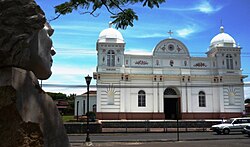
Grecia is a canton in the Alajuela province of Costa Rica.

<span class="mw-page-title-main">Poás (canton)</span> Canton in Alajuela province, Costa Rica

Poás is a canton in the Alajuela province of Costa Rica. The head city of the canton is San Pedro.

<span class="mw-page-title-main">Sarchí (canton)</span> Canton in Alajuela province, Costa Rica

Sarchí is a canton in the Alajuela province of Costa Rica. The head city is in Sarchí Norte district.

<span class="mw-page-title-main">Heredia (canton)</span> Canton in Heredia province, Costa Rica

Heredia is a canton in the Heredia province of Costa Rica. The head city is in Heredia district, and is also the provincial capital of Heredia Province.

<span class="mw-page-title-main">Aserrí (canton)</span> Canton in San José province, Costa Rica

Aserrí is the sixth canton in the San José province of Costa Rica. The head city of the canton is the homonymous Aserrí.

San Pedro is a district of the Poás canton, in the Alajuela province of Costa Rica.

Varablanca is a district of the Heredia canton, in the Heredia province of Costa Rica.

<span class="mw-page-title-main">Tres Ríos, Cartago</span> District in Cartago, Costa Rica

Tres Ríos is a district of the La Unión canton, in the Cartago province of Costa Rica. Its name is derived from its location at the confluence of the Tiribí, Chiquito and Cruz rivers.

Cañas Dulces is a district of the Liberia canton, in the Guanacaste province of Costa Rica.

San Isidro is a district of the Grecia canton, in the Alajuela province of Costa Rica.

Sabanilla is a district of the Alajuela canton, in the Alajuela province of Costa Rica.

San Juan is a district of the Poás canton, in the Alajuela province of Costa Rica.

San Rafael is a district of the Poás canton, in the Alajuela province of Costa Rica.

Carrillos is a district of the Poás canton, in the Alajuela province of Costa Rica.

Sabana Redonda is a district of the Poás canton, in the Alajuela province of Costa Rica.

San Pedro is a district of the Barva canton, in the Heredia province of Costa Rica.

San Pablo is a district of the Barva canton, in the Heredia province of Costa Rica.

San Roque is a district of the Barva canton, in the Heredia province of Costa Rica.

References

  1. 1 2 "Declara oficial para efectos administrativos, la aprobación de la División Territorial Administrativa de la República N°41548-MGP". Sistema Costarricense de Información Jurídica (in Spanish). 19 March 2019. Retrieved 26 September 2020.
  2. División Territorial Administrativa de la República de Costa Rica (PDF) (in Spanish). Editorial Digital de la Imprenta Nacional. 8 March 2017. ISBN   978-9977-58-477-5.
  3. Gagini, Carlos (1917). Los aborigenes de Costa Rica.
  4. 1 2 3 Guillermo E. Alvarado Induni; Oscar Luis Chavarría-Aguilar, Guillermo E Alvarado Induni (2005). Costa Rica: Land of Volcanoes. EUNED. pp. 212–213. ISBN   978-9968-31-366-7.
  5. "Área en kilómetros cuadrados, según provincia, cantón y distrito administrativo". Instituto Nacional de Estadística y Censos (in Spanish). Archived from the original on 24 October 2020. Retrieved 26 September 2020.
  6. "Instituto Nacional de Estadística y Censos" (in Spanish).
  7. "Sistema de Consulta de a Bases de Datos Estadísticas". Centro Centroamericano de Población (in Spanish).
  8. "Censo. 2011. Población total por zona y sexo, según provincia, cantón y distrito". Instituto Nacional de Estadística y Censos (in Spanish). Retrieved 26 September 2020.
  9. "Copia archivada". Archived from the original on 5 March 2016. Retrieved 18 March 2016.