San Rafael (canton)

Last updated
San Rafael
San Rafael de Heredia, Costa Rica.jpg
Skyline of San Rafael city, seen from Ángeles district
Bandera de San Rafael (Costa Rica).svg
Escudo Canton de San Rafael, Heredia, Costa Rica.png
San Rafael (canton)
San Rafael canton
Costa Rica location map.svg
Red pog.svg
San Rafael
San Rafael canton location in Costa Rica
Coordinates: 10°02′30″N84°04′30″W / 10.04167°N 84.07500°W / 10.04167; -84.07500
Country Flag of Costa Rica.svg  Costa Rica
Province Heredia
Creation28 May 1885 [1]
Head city San Rafael
Districts
Government
  Type Municipality
  BodyMunicipalidad de San Rafael
Area
  Total48.39 km2 (18.68 sq mi)
Elevation
1,343 m (4,406 ft)
Population
 (2011)
  Total45,965
  Density950/km2 (2,500/sq mi)
Time zone UTC−06:00
Canton code405
Website www.munisrh.go.cr

San Rafael is a canton in the Heredia province of Costa Rica. [2] [3] The head city is in San Rafael district.

Contents

History

San Rafael was created on 28 May 1885 by decree 10. [1]

Geography

San Rafael has an area of 48.39 km² [4] and a mean elevation of 1,343 metres. [2]

The canton is northeast of the provincial capital city of Heredia, reaching from the suburbs high into the Cordillera Central (Central Mountain Range).

Districts

The canton of San Rafael is subdivided into the following districts:

  1. San Rafael
  2. San Josecito
  3. Santiago
  4. Ángeles
  5. Concepción

Demographics

Historical population
CensusPop.
1892 4,204
1927 4,163−1.0%
1950 5,25426.2%
1963 9,06972.6%
1973 16,01376.6%
1984 22,87142.8%
2000 37,29363.1%
2011 45,96523.3%

Instituto Nacional de Estadística y Censos [5]
Centro Centroamericano de Población [6]

For the 2011 census, San Rafael had a population of 45,965 inhabitants. [7]

Transportation

Road transportation

The canton is covered by the following road routes:

Related Research Articles

<span class="mw-page-title-main">Heredia (canton)</span> Canton in Heredia province, Costa Rica

Heredia is a canton in the Heredia province of Costa Rica. The head city is in Heredia district, and is also the provincial capital of Heredia Province.

<span class="mw-page-title-main">San Isidro (canton)</span> Canton in Heredia province, Costa Rica

San Isidro is a canton in the Heredia province of Costa Rica. The head city is in San Isidro district.

<span class="mw-page-title-main">Flores (canton)</span> Canton in Heredia province, Costa Rica

Flores is a canton in the Heredia province of Costa Rica. The head city is in San Joaquín district.

<span class="mw-page-title-main">San Pablo (canton)</span> Canton in Heredia province, Costa Rica

San Pablo is a canton in the Heredia province of Costa Rica. The head city is in San Pablo district.

Santiago is a district of the San Rafael canton, in the Heredia province of Costa Rica.

San Rafael is a district of the Escazú canton, in the San José province of Costa Rica.

San Rafael is a district of the Puriscal canton, in the San José province of Costa Rica.

San Rafael is a district of the San Ramón canton, in the Alajuela province of Costa Rica.

San Rafael is a district of the Poás canton, in the Alajuela province of Costa Rica.

San Francisco is a district of the Heredia canton, in the Heredia province of Costa Rica.

San Pedro is a district of the Barva canton, in the Heredia province of Costa Rica.

San Roque is a district of the Barva canton, in the Heredia province of Costa Rica.

San Miguel is a district of the Santo Domingo canton, in the Heredia province of Costa Rica.

San Josecito is a district of the San Rafael canton, in the Heredia province of Costa Rica.

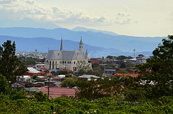
San Rafael is a district of the San Rafael canton, in the Heredia province of Costa Rica.

Ángeles is a district of the San Rafael canton, in the Heredia province of Costa Rica.

Concepción is a district of the San Rafael canton, in the Heredia province of Costa Rica.

San José is a district of the San Isidro canton, in the Heredia province of Costa Rica.

San Isidro is a district of the San Isidro canton, in the Heredia province of Costa Rica.

San Rafael is a district of the Esparza canton, in the Puntarenas province of Costa Rica.

References

  1. 1 2 Hernández, Hermógenes (1985). Costa Rica: evolución territorial y principales censos de población 1502 - 1984 (in Spanish) (1 ed.). San José: Editorial Universidad Estatal a Distancia. pp. 164–173. ISBN   9977-64-243-5 . Retrieved 5 October 2020.
  2. 1 2 "Declara oficial para efectos administrativos, la aprobación de la División Territorial Administrativa de la República N°41548-MGP". Sistema Costarricense de Información Jurídica (in Spanish). 19 March 2019. Retrieved 26 September 2020.
  3. División Territorial Administrativa de la República de Costa Rica (PDF) (in Spanish). Editorial Digital de la Imprenta Nacional. 8 March 2017. ISBN   978-9977-58-477-5.
  4. "Área en kilómetros cuadrados, según provincia, cantón y distrito administrativo". Instituto Nacional de Estadística y Censos (in Spanish). Retrieved 26 September 2020.
  5. "Instituto Nacional de Estadística y Censos" (in Spanish).
  6. "Sistema de Consulta de a Bases de Datos Estadísticas". Centro Centroamericano de Población (in Spanish).
  7. "Censo. 2011. Población total por zona y sexo, según provincia, cantón y distrito". Instituto Nacional de Estadística y Censos (in Spanish). Retrieved 26 September 2020.