Bassendean, Western Australia

Last updated

Bassendean
Perth,  Western Australia
Bassendean Masonic Lodge 050720 gnangarra-116.jpg
The heritage listed Bassendean Masonic Lodge
Bassendean, Western Australia
Coordinates 31°54′18″S115°56′56″E / 31.905°S 115.949°E / -31.905; 115.949
Population10,837 (SAL 2021) [1]
Postcode(s) 6054
Area7.3 km2 (2.8 sq mi)
Location12 km (7 mi) from Perth
LGA(s) Town of Bassendean
State electorate(s) Bassendean
Federal division(s) Perth
Suburbs around Bassendean:
Morley Eden Hill Caversham
Bayswater Bassendean Guildford
Ashfield Ascot South Guildford

Bassendean (once referred to as West Guildford) is a north-eastern suburb of Perth, Western Australia. Its local government area is the Town of Bassendean. [2]

Contents

It is also the name of the sand dune system on the Swan Coastal Plain known as the Bassendean Dune System. [3] [4]

History

In 1829, the land along the Swan River was allotted to British settlers as they arrived in the newly created Swan River Colony. James Henty and his brothers were granted 2,000 acres upon which they grazed their livestock and built a mud-brick homestead. They called their property Stoke Farm. In 1832, the Henty brothers sold the farm to the Colonial Secretary, Peter Broun who renamed the homestead Bassendean. [5]

Over the years the Bassendean property became incorporated into the suburb of West Guildford and in 1922, West Guildford was renamed Bassendean. [6] Flooding in 1929 caused severe damage, especially to the primary school oval. [7]

In December 1934, Bassendean Road Board held a referendum, seeking approval to borrow funds for the improvement of an area, known as Hays Swamp, on the edge of the townsite. The development would include a bowling green with floodlights, a croquet lawn, Bassendean Oval, tennis courts and provisions for other sports. [8]

Rail heritage

Bassendean is home to the Western Australian Rail Transport Museum which opened in 1974. [9] The display has a collection of steam and diesel locomotives, some of which have been restored to operating conditions. Also as part of the collection are a number of carriages and other equipment associated including the Zanthus station and a signal box from Perth station. [10] The West Australian Model Railway Club is also housed within the complex. [11] The display's centrepiece is a working scale model featuring engine characters from the children's series Thomas the Tank Engine and Friends .

Facilities

Cyril Jackson Senior High School was built in 1962, and was converted into Cyril Jackson Senior Campus in 1990 to provide specialised study for post high school students gaining entrance into university study. Bassendean railway station is served by Transperth Midland line services. [12]

Transport

Bus

Rail

Industry

Bassendean has had an involvement in railway rolling stock construction and maintenance since Commonwealth Engineering opened a plant in 1951. [18] It closed in the 1980s, with Goninan later taking it over. [19] [20]

Notable people

See also

Related Research Articles

Dianella is a suburb of Perth, Western Australia. It is within the local government area of the City of Stirling.

<span class="mw-page-title-main">Morley, Western Australia</span> Suburb of Perth, Western Australia

Morley is a suburb of Perth, within the City of Bayswater local government area, situated approximately 10 kilometres (6 mi) northeast of the Perth central business district. It contains the Galleria Shopping Centre, one of Perth's larger shopping centres. Morley bus station is located in the car park of the shopping centre. From the late 1950s, Morley began to develop as a major shopping and commercial centre.

The Midland line is a suburban rail service on the Transperth network in Perth, Western Australia. It runs on the Eastern Railway through Perth's eastern suburbs and connects Midland with Perth. Travelling from Midland, the trains terminate at Fremantle on the Fremantle line.

<span class="mw-page-title-main">Bassendean railway station</span> Railway station in Perth, Western Australia

Bassendean railway station is a Transperth station located in Bassendean, 10.8 kilometres (6.7 mi) north-east of Perth railway station, on the Midland Line.

<span class="mw-page-title-main">Claremont railway station, Perth</span> Railway station in Perth, Western Australia

Claremont railway station is a railway station on the Transperth network in Western Australia. It is located on the Fremantle and Airport lines, 9.3 kilometres from Perth station serving the suburb of Claremont.

<span class="mw-page-title-main">Burswood, Western Australia</span> Suburb of Perth, Western Australia

Burswood is an inner southeastern suburb of Perth, Western Australia, located immediately across the Swan River from Perth's central business district (CBD). Its local government area is the Town of Victoria Park. Burswood is the location of the State Tennis Centre, Perth Stadium, Belmont Park Racecourse, and the Crown Perth casino and hotel complex.

Eden Hill is an eastern suburb of Perth, Western Australia, located within the Town of Bassendean. The origin of its name is unknown, either coming from a farm in the area or an estate name used by Henry Brockman when he subdivided the area in 1892. It was approved as a suburb in 1954. The Swan Valley Nyungah Community was in the area.

Embleton is a suburb of Perth, the capital city of Western Australia, located 7 kilometres (4.3 mi) north-east of the central business district, between the suburbs of Morley and Bayswater. Its local government area is the City of Bayswater.

Wembley is a western suburb of Perth, Western Australia, located within the Town of Cambridge. Its postcode is 6014.

<span class="mw-page-title-main">Woodbridge, Western Australia</span> Suburb of Perth, Western Australia

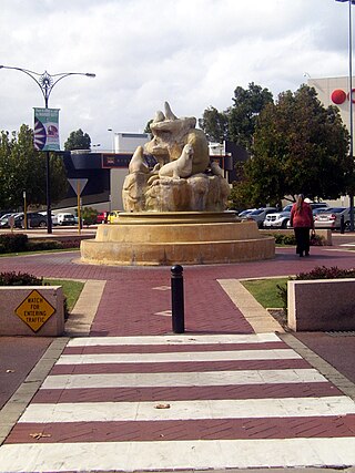
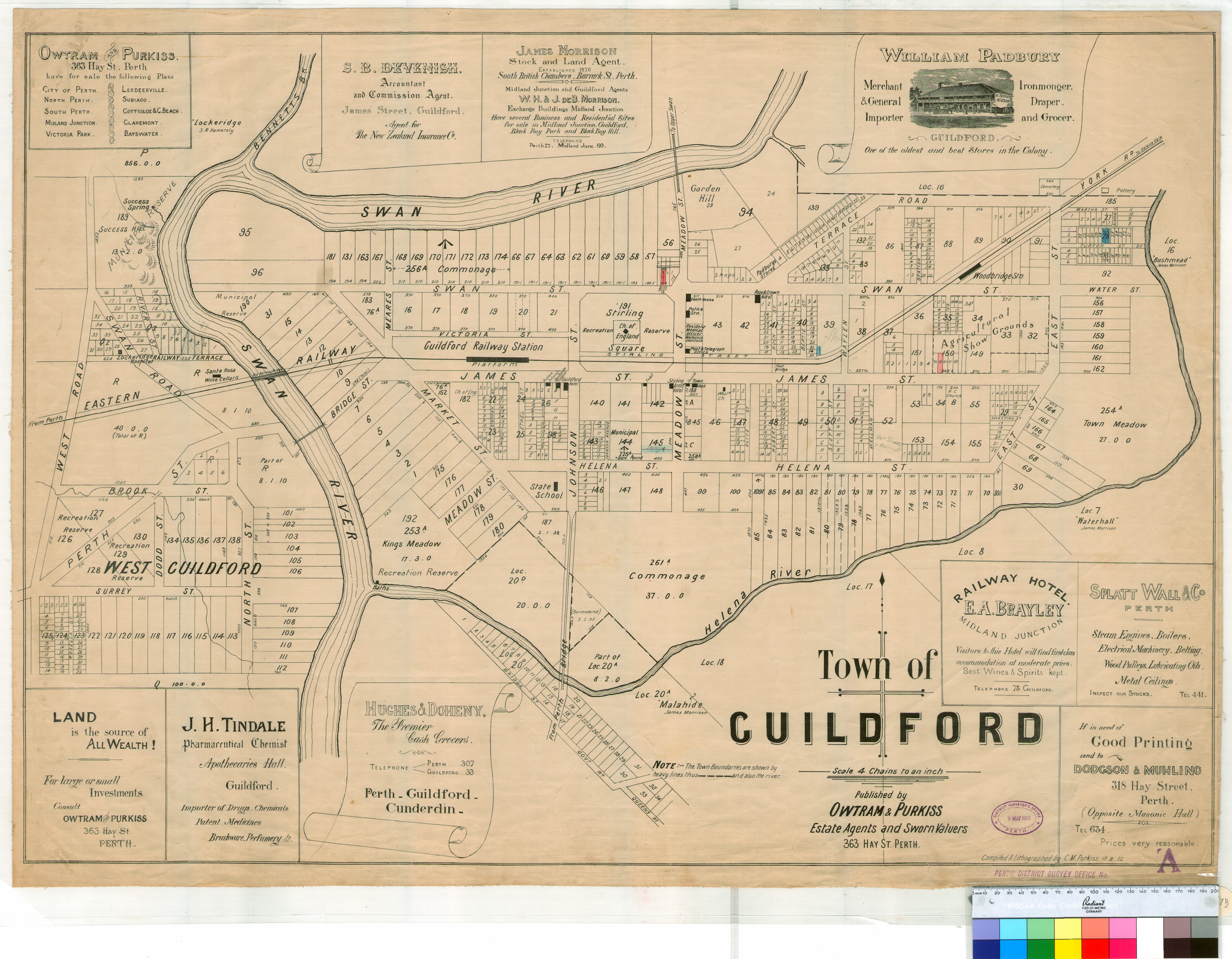
Woodbridge is a suburb of Perth, Western Australia, located within the City of Swan local government area. Formerly part of Midland and previously informally named West Midland, its name, which was officially gazetted on 1 March 2001, is from Governor James Stirling's original 1829 land grant which he named after his wife's family property near Guildford in England.

<span class="mw-page-title-main">Swan View, Western Australia</span> Suburb of Perth, Western Australia

Swan View is an eastern suburb of Perth, Western Australia. Its local government areas are the City of Swan and the Shire of Mundaring. It is 25 kilometres (16 mi) from Perth in the Perth Hills on the edge of the Darling Scarp, just to the west of the John Forrest National Park, east of Roe Highway and north of the Great Eastern Highway.

<span class="mw-page-title-main">Ellenbrook, Western Australia</span> Suburb of Perth, Western Australia

Ellenbrook is a northeastern suburb of Perth, Western Australia, about 30 km (19 mi) from Perth's central business district (CBD), located within the City of Swan. Ellenbrook, and its neighbouring suburbs of The Vines and Aveley, are unusual for Perth in being a significant distance from neighbouring suburbs. Given this relative isolation and the distance from the CBD, Ellenbrook has been designed and developed as a self-sustainable community. Since the upgrade of Gnangara Road and the completion of the Tonkin Highway Northlink, access to Ellenbrook has improved. The Morley–Ellenbrook railway line is well underway as at June 2021 and this will enable better public transport. At the time of the 2016 census there were 22,681 people living in the gazetted suburb, by June 2018, it was estimated that the urban population for Ellenbrook and surrounds had grown to 41,382. It is envisioned that Ellenbrook will eventually become a satellite city, with a population of 80,000.

<span class="mw-page-title-main">Gooseberry Hill, Western Australia</span> Suburb of Perth, Western Australia

Gooseberry Hill is a suburb of Perth, Western Australia, located within the City of Kalamunda. It is the site of Gooseberry Hill National Park.

<span class="mw-page-title-main">East Fremantle, Western Australia</span> Suburb of Perth, Western Australia

East Fremantle is a suburb of Perth, Western Australia, located 13 kilometres (8.1 mi) south-west of the central business district. The suburb is mainly residential, and is coterminous with the Town of East Fremantle local government area.

<span class="mw-page-title-main">Bayswater, Western Australia</span> Suburb of Perth, Western Australia

Bayswater is a suburb 6 km (4 mi) north-east of the central business district (CBD) of Perth, the capital of Western Australia. It is just north of the Swan River, within the City of Bayswater local government area. It is predominantly a low-density residential suburb consisting of single-family detached homes. However, there are several clusters of commercial buildings, most notably in the suburb's town centre, around the intersection of Whatley Crescent and King William Street and a light industrial area in the suburb's east.

<span class="mw-page-title-main">Hazelmere, Western Australia</span> Suburb of Perth, Western Australia

Hazelmere is a suburb of Perth, 14 kilometres (9 mi) east of the Perth central business district, in the City of Swan.

Kiara is a suburb of Perth, Western Australia, situated approximately 11 kilometres (7 mi) northeast of Perth's central business district and 8 kilometres (5 mi) from Midland, and located within the City of Swan local government area.

<span class="mw-page-title-main">South Guildford, Western Australia</span> Suburb of Perth, Western Australia

South Guildford is a suburb of Perth, Western Australia, located in the City of Swan local government area.

<span class="mw-page-title-main">Perth (suburb)</span> Suburb of Perth, Western Australia

Perth is a suburb in the Perth metropolitan region, Western Australia that includes both the central business district of the city, and a suburban area spreading north to the northern side of Hyde Park. It does not include the separate suburbs of Northbridge or Highgate. Perth is split between the City of Perth and the City of Vincent local authorities, and was named after the city of the same name in Scotland.

<span class="mw-page-title-main">Walter Road</span> Road in Perth, Western Australia

Walter Road is a road in the north-eastern suburbs of Perth, Western Australia. Formerly a continuous road, it is now discontinuous at Tonkin Highway. The western section of the road is known as Walter Road West, and the eastern section of the road is known as Walter Road East.

References

  1. Australian Bureau of Statistics (28 June 2022). "Bassendean (WA) (suburb and locality)". Australian Census 2021 QuickStats. Retrieved 28 June 2022.  OOjs UI icon edit-ltr-progressive.svg
  2. "Town of Guildford" (pdf). State Records Office of Western Australia. Perth, WA: Government of Western Australia, Department for Culture and the Arts. 10 August 1902. Retrieved 27 January 2016.
  3. Broun, Llewellyn (1 January 2004), Banksia Woodland Resilience To Groundwater Drawdown On The Gnangara Mound, Edith Cowan University, Research Online, Perth, Western Australia, retrieved 20 August 2018
  4. Pesjak, Lea; Murdoch University. Faculty of Science and Engineering (2011), Low sulfur, potentially-acidic soils and sediments of the Bassendean Dune System, Perth, Western Australia , retrieved 20 August 2018
  5. Bassett, Marnie (1954). The Hentys, and Australian colonial tapestry. London: Cambridge University Press.
  6. "History". Town of Bassendean – Home by the Swan. Town of Bassendean. Archived from the original on 28 February 2015. Retrieved 10 April 2015.
  7. "FLOODED SCHOOLGROUND". The Daily News . Perth, WA: National Library of Australia. 16 May 1929. p. 6 Edition: HOME (FINAL) EDITION. Retrieved 11 April 2015.
  8. "IMPROVEMENT SCHEME FOR BASSENDEAN". The Daily News . Perth, WA: National Library of Australia. 15 December 1934. p. 9 Edition: LATE CITY. Retrieved 10 April 2015.
  9. Bassendean Railway Museum Rail Heritage WA
  10. Here & There Australian Railway Historical Society Bulletin issue 701 March 1996 page 95
  11. Home West Australian Model Railway Club
  12. Bassendean Station Transperth
  13. Bus Route 45 Timetable. Transperth. 13 April 2024 [effective from {{{effective_from}}}].
  14. "Route 341". Bus Timetable 104 (PDF). Transperth. 28 April 2023 [effective from 12 June 2023].
  15. "Route 342". Bus Timetable 104 (PDF). Transperth. 28 April 2023 [effective from 12 June 2023].
  16. "Route 353". Bus Timetable 100 (PDF). Transperth. 5 January 2024 [effective from 28 January 2024].
  17. "Route 955". Bus Timetable 99 (PDF). Transperth. 26 April 2023 [effective from 12 June 2023].
  18. Four Firms Combine to Build Freight Cars in WA Railway Transportation October 1951 page 44
  19. Here & There Australian Railway Historical Society Bulletin issue 609 July 1988 page 57
  20. UGL 500 Not Out Motive Power issue 86 March 2013 page 59
  21. Hasluck, Alexandra (1983). "Hackett, Deborah Vernon (1887–1965)". Australian Dictionary of Biography . National Centre of Biography, Australian National University. ISSN   1833-7538 . Retrieved 30 March 2015.
  22. Ducey, Liam (4 July 2014). "Rolf Harris removed from Bassendean history following sex conviction". WAtoday. Retrieved 31 May 2023.
  23. Foster, Brendan (4 July 2014). "Rolf Harris's home town removes all signs of former favourite son". The Guardian. Retrieved 31 May 2023.

Further reading

Commons-logo.svg Media related to Bassendean, Western Australia at Wikimedia Commons