$325million (2011 USD) (insured losses; costliest in Texas history)
Ignition
Cause
Sparks created following contact between wind-snapped trees and power lines
Map
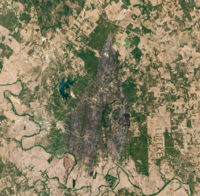
Perimeter of Bastrop County Complex Fire (map data)
The fire's location in Texas
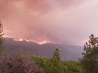
The Bastrop County Complex fire was a conflagration that engulfed parts of Bastrop County, Texas, in September and October2011. The wildfire was the costliest and most destructive wildfire in Texas history and among the costliest in U.S. history, destroying 1,696structures and causing an estimated $350million in insured property damage. An exceptional drought, accompanied by record-high temperatures, affected Texas for much of 2011. Vegetation consequently became severely parched throughout the state, and over the year an unprecedented amount of land in the state was burned by numerous wildfires. In early September2011, the presence of Tropical Storm Lee to the east produced strong northerly winds over the state, exacerbating the preexisting dry weather to produce critical fire conditions. On the afternoon of September4, 2011, three separate fires ignited in the wildland–urban interface east of Bastrop, Texas, after strong winds caused by the nearby tropical storm snapped trees onto power lines. Within 48hours, the fires merged into one blaze that quickly consumed parts of Bastrop State Park and parts of the Lost Pines Forest, as well as homes in nearby subdivisions. Most of the conflagration's spread and destruction occurred within a week of ignition, as the forward advance of the wildfire mostly stopped after September7. The wildfire was largely contained in September, though the firebreak was briefly breached in early October. On October10, the Bastrop County Complex was declared controlled, and the fire was declared extinguished on October29 after 55days of burning within the fire perimeter.
Two people were killed by the wildfire, and another twelve people were injured. The fire perimeter encircled an area spanning at least 32,000acres (12,950hectares). Homes were destroyed in ten subdivisions, of which Circle-D County Acres and Tahitian Village sustained the most significant property damage. The wildfire destroyed more homes than any single fire in Texas history by nearly a factor of ten. Around 96percent of Bastrop State Park was scorched by the wildfire. Roughly 1.5million trees across 16,200acres (6,600hectares) of forest were either killed directly by the fire or fatally damaged. Despite the severe habitat loss, populations of local herpetofauna were not significantly affected by the fire, though extensive soil erosion was enabled by the loss of groundcover.
The Bastrop County complex occurred within the Lost Pines Forest of Texas, a region characterized by a loblolly pine (Pinus taeda) canopy, a yaupon (Ilex vomitoria) understory, sandy soils, and a mixed topography of flat terrain and rolling hills.[2] This area is near the city of Bastrop, Texas, which itself is located about 30mi (48km) southeast of Austin, the state capital of Texas.[3]Oak trees, Ashe juniper (Juniperus ashei), shrubs, and grasses also comprise the vegetation of the region. The Lost Pines cover a 70sqmi (180km2) area and are a disjunct population separated from the Piney Woods by 100mi (160km) of agricultural land.[2][4] Historical wildfire behavior in Texas has been strongly influenced by human activities and changes in land use, affecting the makeup and composition of the vegetation impacted by the fire. The prevalence of cattle in Bastrop County between the 1860s and mid-1880s may have led to a reduction in fires in and around what is now Bastrop State Park via the grazing of potential fuels. However, the harsh winter of 1886–1887 brought an end to open-range grazing by 1890; this may have allowed for an increase in wildfires in subsequent decades. Greater utilization of wildfire suppression after the mid-1940s led to an increase in tree density in the region, further augmented by the concurrent planting of additional loblolly pine trees. The reduction in wildfires after the 1940s–leading to the lowest fire activity since at least 1720–led to a build-up in vegetation density (and thus potential fuels for a wildfire) to unprecedented levels.[5] In the years leading up to the Bastrop County Complex, the only large wildfire in the area was the Wilderness Ridge Fire in 2009, which burned 1,491acres (603hectares).[6] The vegetation in and around Bastrop State Park indicates that no fire before 2011, dating back to at least 1650, matched the severity of the Bastrop County Complex.[5]
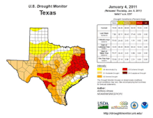
An extreme drought characterized by an all-time record lack of precipitation and warmth persisted throughout Texas prior to the wildfire.
Texas endured one of its worst droughts in recorded history throughout much of 2011. The drought began to materialize following a drier than average autumn and winter beginning in 2010, but it worsened to widespread and extreme levels after March2011. The average precipitation total statewide was 0.29in (7.4mm) compared to the 1981–2010 average of 2.18in (55mm) in March, making it the state's driest March on record. The period from October2010 to September2011 was the driest 12-month period in Texas history, with the statewide average rainfall falling below the previous record set during the 1950s Texas drought by 2.35in (60mm).[7] Based on paleoclimate reconstructions, the summer of 2011 may have been the fourth driest summer in Texas since 996.[5] Temperatures during the summer of 2011 also rose to record highs, with statewide average temperatures from June through August2011 eclipsing the previous record high by 2°F; each of the three months was their respective warmest month on record.[7] Additionally, the mean statewide temperature in those three months were the hottest summer months recorded in any U.S. state on record, topping the record heat set in Oklahoma during the Dust Bowl.[8][9]
The nearby Tropical Storm Lee induced strong northerly winds over Texas in early September2011, producing conditions supportive of wildfire ignition and growth.
Dry conditions perpetuated by the drought led to widespread die-offs of trees across central and eastern Texas by the early fall of 2011, and most forests throughout the state were exceptionally dry;[7] 251 of the 254counties in Texas had bans on outdoor burning in effect in September2011.[3] The moisture content of all vegetation types within Bastrop County diminished to record lows during the course of the drought, making them increasingly susceptible to combustion.[2] According to the U.S. Drought Monitor,[lower-alpha 1] the entirety of Bastrop County had remained in exceptional drought–the most severe drought conditions–since the week of May10, 2011, and had been experiencing at least abnormally dry conditions since at least the week of October 26, 2010.[11]Numerous wildfires occurred across Texas and adjoining states in 2011; more land area was burned in Texas and Oklahoma since official recordkeeping began in 2002.[5] Between November2010 and September2011, Texas wildfires engulfed over 3.7million acres (1.5million hectares) of land; within the first week of September2011, 135,000acres (54,600hectares) burned.[3]
Amid the exceptional drought in early September2011, Tropical Storm Lee developed in the Gulf of Mexico and produced northeasterly winds across much of East Texas beginning on September3; the storm itself was centered over the gulf south of the central Louisiana coast.[2] These winds were further accelerated by the presence of high air pressure over Texas.[12] Temperatures ahead of a cold front concurrently moving east of the Rocky Mountains rose above 100°F (38°C) the day before the fire ignited and on the day of ignition, resulting in relative humidity values falling below 20percent in the vicinity of Bastrop. Rainfall associated with the tropical storm did not expand west of Interstate 45, allowing the dry conditions in the Bastrop area to persist.[2] Winds decreased over the night of September3 and into the morning of September4, but the approach of the cold front into the Bastrop area resulted in the acceleration of winds oncemore.[3] Around the time of the Bastrop County Complex's initiation on September4, the distant tropical storm was generating sustained winds of 12–14mph (19–23km/h) and wind gusts of 25–31mph (40–50km/h) in the Bastrop area.[2] The high temperature on September4 was 101°F (38°C), and the relative humidity bottomed out at 20percent.[6] This combination of conditions led the Storm Prediction Center to forecast critical fire weather conditions over southern and central Texas for September4.[13] Throughout Texas, local fire departments responded to 227fires on September4,[14] 57 of which were new fires.[15] The likelihood of a wildfire igniting given the prevailing weather conditions was around 90percent.[16]
Fire progression
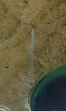
The smoke plume from the wildfire as observed by the MODIS onboard the Terra satellite on September 5
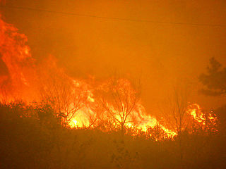
The wildfire complex began as three individual fires whose ignitions were reported within three hours on September4, 2011.[2][4] The first fire was ignited by fallen power lines near Circle D-KC Estates, Texas, located 16mi (10km) northeast of Bastrop.[4] A nearby homeowner called 9-1-1 at 2:20p.m. CDT, reporting the fire.[14] An investigation performed by the Texas Forest Service (TFS) determined a point of origin near 258 Charolais Drive. Strong winds caused a pine tree to snap 8ft (2.4m) above the ground, resulting in the upper trunk falling atop power lines and triggering sparks that reached the dry grass and leaf litter below.[16][17] The first fire grew quickly after ignition; the Bastrop volunteer fire department requested fire suppression equipment from the TFS at 2:25p.m. CDT but determined at 2:33p.m. CDT that the blaze was uncontrollable, prompting evacuations.[14] Thirty-two minutes later after the first ignition, a second fire initiated 4mi (6.4km) to the north near Schwantz Ranch Road and U.S. Highway 290; the TFS determined that this second ignition was also caused by a tree falling upon power lines.[4][16][14] An investigation by Bluebonnet Electric Cooperative, which services the power lines in the region, arrived at similar conclusions for the cause of the fires.[18] Pushed southward by a strong northerly wind, the wildfire crossed Texas State Highway 21 at 3:02p.m. CDT. Mike Fisher, the emergency management coordinator for Bastrop County, formally declared the situation a disaster at that time, authorizing aid from outside of the county. The conflagration subsequently spread into Bastrop State Park and began to encroach upon Texas State Highway 71. The highway's right-of-way formed a preexisting firebreak spanning 325ft (99m) across. Firefighters set dead grass in the highway's median strip to deter expansion of the flames south of the highway, but were unsuccessful; the first fire crossed the highway at 4:07p.m. CDT.[14] The two initial fires grew and aggregated into a single wildfire by 5p.m. CDT after joining near Cardinal Drive, continuing to spread through Bastrop State Park and across Texas State Highway 71.[2][14]
The third individual fire was ignited by a tree contacting a power line south of the highway near Tahitian Drive at 5:16p.m. and eventually merged with the larger fire;[3][4][14] the complex of wildfires merged into a single wildfire within 48hours of ignition.[2] During the first hours of the wildfire, the firefront advanced at 5mph (8.0km/h) through the pine and yaupon vegetation.[2] High winds carried hot embers far from the firefront, igniting fires as far as 3mi (4.8km) away. Fire whirls were also observed along the firefront.[3] In addition to the strong winds, horizontal convective rolls embedded within the wind flow enabled the wildfire to quickly advance along the tops of the forest canopy, resulting in long streaks of intensely burned vegetation.[6][14] By the end of September4, the combined wildfire had scorched an area roughly 14mi (23km) long and up to 6mi (9.7km) wide, covering 14,000acres (5,660hectares) of land.[14][19]
The passage of a cold front ushered in a decrease in temperatures on September5. The movement of Tropical Storm Lee east away from Texas slackened winds, though gusts remained in the 20–25mph (32–40km/h) range. The combination of gusts with continued low relative humidity and strong atmospheric instability perpetuated environmental conditions conducive to large fire growth.[3] The Bastrop County Complex remained 0percent contained heading into the afternoon of September5,[20] with its advance still unperturbed by firefighting efforts.[21] Flames reached the Colorado River and crossed south of the river twice during the day, hamstringing the ability for firefighters to obtain water.[22][23] State officials stated on September5 that the Bastrop County Complex had destroyed 476homes, setting a record for the most homes destroyed by a single wildfire in Texas. The fire had engulfed over 25,000acres (10,000hectares) but its spread north of the Colorado River had slowed. Over 250firefighters were working on containing the fire's spread, aided by bulldozers to create firebreaks and TFS air tankers.[24]
The conflagration remained completely uncontained on September6. The TFS released a statement that day describing the fire's behavior as "unprecedented" and that "no one on the face of this Earth has ever fought fires in these extreme conditions."[25][26] Considerable progress in containing the fire was made on September7, with fire containment reaching 30percent and no additional structures being destroyed. The outward advance of the wildfire was mostly stopped, but burning continued within the preexisting burn area.[27] The TFS assessed that 785homes had been destroyed by September7,[28] but the enumeration of the number of destroyed homes increased significantly the following day to 1,386 based on surveys conducted by Bastrop County officials.[29] The wildfire was 50percent contained by noon on September10 and 70percent contained by noon on September12.[30] Dry weather had remained in place over the Bastrop area for nearly two weeks after the wildfire first ignited, but light rain and humid conditions prevailed for the first time on September17, attenuating flare-ups within the burn area; at the time, the fire was 85percent contained.[31] After September22, 18days after ignition, the wildfire was 95percent contained.[32] Beneficial rains on September24–25, including totals as much as 2in (51mm) in parts of Bastrop County, allowed firefighters to target hot spots more deeply embedded within the fire perimeter.[33]
The wildfire spread past a firebreak on October4 towards the northern portions of the previous burn scar, burning 309acres (125hectares) of land including parts of Griffith League Ranch. This extension of the Bastrop County Complex was called the Old Potato Road fire and was fully contained on October10.[32][34] The Bastrop County Complex was declared controlled on October10.[4] However, flare-ups within the burn area continued until October29, when the fire was completely extinguished. In total, the wildfire lasted for 55days.[35]
Another fire, called the Union Chapel Fire, began on the afternoon of September5 near Cedar Creek High School some 18mi (29km) to the west of the Bastrop County Complex.[36][37] Though a discrete fire, TFS operations considered the Union Chapel Fire a part of the Bastrop County Complex.[38][39] The fire consumed 912acres (369hectares) and destroyed 25homes and 2businesses, prompting the evacuation of 200people, but was 90percent contained by September8.[40][41][42][3]
Firefighting efforts
Around 2.3million gallons (8.7million liters) of water and fire retardant were dropped on fires in Bastrop County in September 2011.
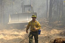
More than 30airplanes and helicopters from the Texas National Guard and TFS were involved in aerial firefighting efforts.[43] Within the first week of the fire, aircraft performed 1,647drops of water or fire retardant on the conflagration. Combined with the nearby Union Chapel Fire, 2,367drops of water or fire retardant were performed in September2011, equivalent to 2.3million gallons (8.7million liters) of fire suppression payload. The most intense aerial firefighting operations occurred on September6.[3]Tanker 910–a converted McDonnell Douglas DC-10 airtanker–was brought to Austin–Bergstrom International Airport for use in fighting the fire but was ultimately unneeded by the time the requisite fire retardant mixing facility was established at the airport.[44][45][46] The converted DC-10 and four Lockheed C-130 Hercules tankers remained on standby at the airport for other deployments after the Bastrop fire diminished.[47] Firefighting crews from 30agencies assisted in combating the wildfire in its first days.[48] On September9, 676personnel were working on fire, the most of any day during the wildfire's spread.[3] In addition to the aerial firefighting efforts, 27bulldozers and 47pumpers were deployed to help attack the fire.[43] One fire engine was engulfed by the flames on September4; the crew were rescued, but the truck melted in the fire.[3] The Texas Intrastate Fire Mutual Aid System mobilized fifteen "strike teams" composed of 192personnel to the Bastrop County Complex fire.[3]FEMA authorized eight Fire Management Assistance Grants for Texas wildfires concurrent with the Bastrop County Complex, subsidizing firefighting equipment.[27] On September25, the fire incident command transitioned its response from type 1 to type 3 as the wildfire became increasingly controlled.[33][lower-alpha 2]
Closures and evacuations
The first evacuations of homes began within 20minutes of the first fire being reported on September4.[16] The evacuation of Bastrop State Park was ordered at 3:16p.m. CDT on September4, while evacuation of neighborhoods south of Texas State Highway 71 began at around 3:30 p.m. CDT that day, less than an hour before the fire crossed the highway.[14]Buescher State Park was also closed on September4 but reopened on September20 without the fire entering the extent of the park.[50][51] Twenty subdivisions were subject to evacuations during the spread of the fire, including mandatory evacuation orders, accounting for some 5,000people.[52][15][48] Some residents were allowed to examine the hardest-hit neighborhoods for the first time on September8.[53] A staggered reentry of residents to additional evacuated subdivisions began on September12 and continued through September15 as the wildfire subsided.[54] Bastrop Middle School and the First Baptist Church in Smithville, Texas, were designated as shelters for wildfire evacuees.[55] Volunteers rescued 160animals from the Bastrop Animal Shelter, evacuating them to Austin.[56]Bastrop Independent School District and Smithville Independent School District closed their schools on September6 and resumed classes on September12;[57][58][59] the school closures also resulted in cancellations of football and volleyball events for area schools.[60] Bluebonnet Electric Cooperative relocated around 50 of its workers from its Bastrop headquarters to Giddings, Texas, on the night of September4 to continue monitoring the electric grid.[61] Texas State Highway 71 was closed during the fire and reopened at 8:00a.m. CDT on September10.[62] Texas State Highway 21 was also closed but reopened on September12.[54] The breach of the firebreak on October4 prompted additional road closures and the evacuations of 25–30homes.[63]
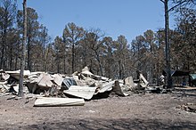
The conflagration consumed at least 32,000acres (12,950hectares) of land, burning across subdivisions within the wildland–urban interface, unmanaged private land, and much of Bastrop State Park.[2] Two people were killed and twelve people were injured.[15] The fire destroyed 1,660homes and 36businesses, accounting for approximately 59.4percent of the structures caught within the wildfire's burn perimeter.[15][3] Most of the destroyed structures were burned by the wildfire within the first three days of ignition.[3] In some cases, homes burned so intensely that their foundations ruptured.[64] Another 1,091homes were saved by firefighting efforts. Homes were destroyed in ten subdivisions, with the greatest losses occurring in Circle-D County Acres and Tahitian Village subdivisions. Structures were destroyed in five incorporated and unincorporated communities: Bastrop, Cedar Creek, McDade, Paige, and Smithville. A majority of the structures destroyed were in the Bastrop area.[3] Based on the number of homes destroyed, the Bastrop County Complex was the most destructive in Texas history and third most destructive in U.S. history; however, accounting for fires for which official enumerations of damage do not exist, the fire may have been the sixth most destructive in U.S. history.[7] The previous record for the most homes destroyed by a single fire in Texas was 168, set by the Possum Kingdom Fire in April2011.[3] The Insurance Council of Texas estimated that the fire inflicted $325million in insured losses, making the Bastrop County Complex the costliest wildfire in Texas history and among the costliest in U.S. history.[65][66] The estimated toll exceeded the estimated losses statewide from fires in 2009–the costliest year for wildfires in the state before 2011.[65][67] Accounting for the populations of counties in which destructive wildfires have occurred, the Bastrop County complex may have at the time been the costliest conflagration per capita in the wildland–urban interface in U.S. history based on an estimated loss of $209.3million as estimated by the Bastrop Tax Appraisal District.[3] Power outages caused or prompted by the fire affected 3,800homes;[68] all power was restored by September27.[69]
The two people killed by the fire were found on September6, 2011, after law enforcement and search crews combed through burned neighborhoods.[70][71] One person was found near Smithville and the other near Paige; both of the fatalities were in neighborhoods that had been evacuated.[72][73]Urban Search and Rescue Texas Task Force 1 was later deployed to the area to search for additional victims.[74]
The Bastrop County Complex fire destroyed more homes than any other wildfire in Texas history.
The Bastrop County Complex affected 96percent of Bastrop State Park,[35] leaving only around 100acres (40hectares) untouched.[75] Seventy percent of the park was severely burned.[76] The only unburned areas were the park's golf course, the curtilage around structures, and areas subjected to prescribed fires in February2011.[3] Two scenic overlook buildings within the park built in the 1930s, among other historic structures, were destroyed.[77] The regional state parks office near Bastrop State Park was also destroyed by the fire.[55] However, firefighters successfully prevented the wildfire from damaging many other cabins and structures in the park built by the Civilian Conservation Corps.[78] Vegetation in the park suffered extensively, leading to the loss of around 70percent of canopy trees and 90–92percent of understory vegetation.[3] The elimination of groundcover by the fire enabled extensive soil erosion within the park following heavy rainfall in January2012, damaging archeological sites including those dating back to the Paleo-Indians.[79]
The fire also spread across 39percent of the Lost Pines ecoregion.[80] Most of the habitat of the endangered Houston toad (Anaxyrus houstonensis) was destroyed by the wildfire.[77] Their abundances were not strongly affected by the habitat loss in subsequent years,[81] though the fire may have pushed their populations beyond their typical range within Bastrop County.[82] Similarly, the populations of other native amphibians and reptiles–namely the six-lined racerunner (Cnemidophorus sexlineatus), southern prairie lizard (Sceloporus consobrinus), and Hurter's spadefoot toad (Scaphiopus hurteri)–did not decrease as a result of the fire.[80]Riparian forests–common nesting habitats for birds–remained largely intact in the fire.[3]
Approximately 1.5million trees were either killed by the fire or assessed by the TFS as being "alive but likely to die soon". More than 16,200acres (6,600hectares) of forest burned in the wildfire, and over 24million ft3 (680,000m3) of timber was either destroyed or irreparably damaged, representing 78percent of trees in the areas affected by the fire.[83] The fire burned unevenly, leaving some areas lightly scorched while burning other areas so thoroughly that all nutrients were purged from the underlying soil.[2] The strong winds that sparked the fire carried ashes and embers to great distances. Softball-sized aggregations of charred pine trees were found in Rosanky, Texas, 15mi (24km) south of the Colorado River.[14]
Reaction
Political response
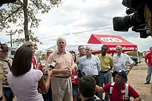
Senator John Cornyn and FEMA Federal Coordinating Officer Kevin L. Hannes holding a press conference on September 17, 2011
On September 7, 2011, President Barack Obama personally telephoned Perry to discuss the fires. That same day, the White House issued a formal statement, saying that "Over the last several days, at the request of the Governor, the Administration has granted eight Fire Management Assistance Grants, making federal funds available to reimburse eligible costs associated with efforts to combat the fires. FEMA is actively working with state and local officials to conduct damage assessments and to identify areas where additional federal assistance may be warranted."[88]
Community and social media efforts
Members of the community were noted for voluntarily working to save several homes from destruction by the wildfire.[89] On September 7, a Facebook page entitled Bastrop Fire – Adopt a Family was created to help match up homeless victims with those willing to help house them or provide other assistance.[90] Local musicians and organizations based in nearby Austin, Texas, organized a benefit concert entitled "Fire Relief: The Concert for Central Texas" to raise money for victims of the Bastrop fire. The concert was hosted by Kyle Chandler at the Frank Erwin Center in Austin on October17 and featured several musicians including Christopher Cross, the Dixie Chicks, and Willie Nelson, raising over $500,000.[91][92]
On September 27, 2011, the Bastrop County Long Term Recovery Team (BCLTRT) was formed as a volunteer organization of community members, eventually becoming a 501(c)(3) organization in February2012. The BCLTRT helped rebuild 133homes in Bastrop County destroyed by both the Bastrop County Complex fire and subsequent disasters, with additional funding from the American Red Cross and the Salvation Army.[93][94]
In the aftermath of the wildfire, students at Texas A&M University formed Aggie Wildfire Relief to raise funds for wildfire recovery. The organization started a "Wear White, Wave Maroon" campaign for a home football game against Baylor University on October 15, 2011, raising over $16,000 from the sales of white T-shirts and maroon towels for donations towards the American Red Cross and the Texas Wildfire Relief Fund.[95][96][97]
On September 9, 2011, U.S. President Barack Obama granted a disaster declaration requested by Texas Lieutenant Governor David Dewhurst, authorizing approximately $16.1million in federal monetary assistance for individuals in Bastrop County affected by the wildfire.[98][99] The grant followed preliminary assessments conducted by four FEMA teams of the damage.[100] The government of Bastrop County anticipated that post-fire cleanup would cost $25million, with FEMA funding $19million.[101] The destruction of property led to five years of reduced property tax revenue for local government entities and services.[102][103] Bastrop County established the Lost Pines Recovery Team in the aftermath of the wildfire to assess the state of the area's natural resources and devise and disseminate best management practices for those resources.[3] The county government planned the removal of 521,000yd3 (398,000m3) of potentially hazardous tree debris, of which 440,000yd3 (336,000m3) were removed by April2012. An additional 65,000yd3 (50,000m3) of construction and demolition debris was also removed by the county. Bluebonnet Electric Cooperative replaced 1,223burned poles in the fire perimeter and added 61mi (98km) of electrical wire for $7.1million.[3]
Vegetation in Bastrop State Park began to regrow after the fire. Recovery efforts were costly, with erosion control costing at least three times the park's annual budget and lolloby pine replanting costing at least seven times the park's annual budget. The park partially reopened on December2, 2011, but closed again the next month following heavy rainfall. After additional park rehabilitation projects were completed, most hiking trails, camping areas, and cabins in the park reopened to the public.[104][76]
Several lawsuits were filed against private companies concerning the inadequate pruning of trees near power lines. A class-action lawsuit filed against the Asplundh Tree Expert Company and Bluebonnet Electric Cooperative was dismissed in 2015. The Bastrop County government, Bastrop County Emergency Services District No. 2, Bastrop Independent School District, Smithville Independent School District filed a lawsuit against Asplundh on April 1, 2016, alleging that the defendant failed to sufficiently prune trees that ultimately damaged power lines and sparked the fires while being aware of the associated risk given the prevailing weather conditions.[105] A third lawsuit involving the same parties was filed in 2018 and reached a $5million settlement in 2020.[106]
↑ Within the Incident Command System, types describe the complexity and breadth of the response to incidents, including wildfires. A Type 1 response indicates the use of national resources for major incidents. A Type 3 response is utilized for extended fire suppression efforts and implies a more localized response.[33][49]
Related Research Articles
Bastrop is a city and the county seat of Bastrop County, Texas, United States. The population was 9,688 according to the 2020 census. It is located about 30 mi (48 km) southeast of Austin and is part of the Greater Austin metropolitan area.
The Houston toad, formerly Bufo houstonensis, is an endangered species of amphibian that is endemic to Texas in the United States. This toad was discovered in the late 1940s and named in 1953. It was among the first amphibians added to the United States List of Endangered Native Fish and Wildlife and is currently protected by the Endangered Species Act of 1973 as an endangered species. The Houston toad was placed as "endangered" on the IUCN Red List of Threatened Species from 1986 to 2022, and has worsened to "critically endangered" since then, with fewer than 250 mature individuals believed to remain in the wild as of 2021. Their kind is threatened every day as they continue to suffer from a loss of habitat, extreme drought, and massive wildfires. Their typical life expectancy is at least 3 years but it may exceed this number.
The DC-10 Air Tanker is a series of American wide-body jet air tankers, which have been in service as an aerial firefighting unit since 2006. The aircraft, operated by the joint technical venture 10 Tanker Air Carrier, are converted wide-body McDonnell Douglas DC-10-30 passenger jetliners, and are primarily used to fight wildfires, typically in rural areas. The turbofan-powered aircraft carry up to 9,400 US gallons of water or fire retardant in an exterior belly-mounted tank, the contents of which can be released in eight seconds. Four air tankers are currently in operation, all DC-10-30 aircraft, with the call-signs Tanker 910, 911, 912 and 914. The original Tanker 910, a DC-10-10, was retired in 2014.
The Yellowstone fires of 1988 collectively formed the largest wildfire in the recorded history of Yellowstone National Park in the United States. Starting as many smaller individual fires, the flames quickly spread out of control due to drought conditions and increasing winds, combining into several large conflagrations which burned for several months. The fires almost destroyed two major visitor destinations and, on September 8, 1988, the entire park was closed to all non-emergency personnel for the first time in its history. Only the arrival of cool and moist weather in the late autumn brought the fires to an end. A total of 793,880 acres (3,213 km2), or 36 percent of the park, burned at varying levels of severity.
Bastrop State Park is a state park in Bastrop County, Texas, United States. The park was established in 1933 and consists of stands of loblolly pines mixed with post oak and junipers.
Cedar Creek is an unincorporated community in Bastrop County, Texas, United States. It is located about 11 miles (18 km) west of the city of Bastrop. The community takes its name from Cedar Creek, a tributary of the Colorado River that is close to the area. Cedar Creek is home to Bastrop County's inaugural public park and McKinney Roughs Nature Park, featuring both natural landscapes and archaeological sites.
The Lost Pines Forest is a 13-mile (21 km) belt of loblolly pines in the U.S. state of Texas, near the town of Bastrop. The stand of pines is unique in Texas because it is a disjunct population of trees that is more than 100 miles (160 km) separated from, and yet closely genetically related to, the vast expanse of pine trees of the Piney Woods region that covers parts of Texas, Arkansas, Louisiana, and Oklahoma.
The 2011 Texas wildfires were a series of destructive wildfires in Texas that occurred in the 2011 fire season. During 2011 in Texas, around 31,453 fires had burned 4,000,000 acres or 16,190 square kilometres, 2,947 homes, and over 2,700 other structures. 47.3% of all acreage burned in the United States in 2011 was burned in Texas. The fires had been particularly severe due to the 2011 Southern US drought that covered the state, and was exacerbated by the unusual convergence of strong winds, unseasonably warm temperatures, and low humidity.
The Las Conchas Fire was a large wildfire in the state of New Mexico, in the United States, in 2011. The fire started in Santa Fe National Forest and burned more than 150,000 acres, threatening Los Alamos National Laboratory and the town of Los Alamos. After five days of burning, it became the largest wildfire in New Mexico state history at the time. It was surpassed in 2012 by the much larger Whitewater-Baldy Complex Fire and in 2022 by the Calf Canyon/Hermits Peak Fire and the Black Fire making the Las Conchas Fire the fourth-largest fire in New Mexico's recorded history.
The 2010–2013 Southern United States and Mexico drought was a severe to extreme drought that plagued the Southern United States, including parts of Texas, Louisiana, Arkansas, Mississippi, Alabama, Georgia, South Carolina, North Carolina, Florida, and Oklahoma; the Southwestern States, including Kansas, Colorado, New Mexico, and Arizona; as well as large parts of Mexico, in a three-year pattern from 2010 to 2013.
The 2012 Colorado wildfires were an unusually devastating series of Colorado wildfires, including several separate fires that occurred throughout June, July, and August 2012. At least 34,500 residents were evacuated in June.
The Hidden Pines Fire was a wildfire in Bastrop County, Texas in October 2015. It burned over 4,582 acres and destroyed 64 homes and many other buildings. An investigation by the Texas A&M Forest Service Law Enforcement Department said the fire was likely caused by an accident on Luecke ranch near Smithville, which produced a spark that came out from around a cutting unit pulled behind a tractor. The spark ignited dry grass around the tractor, starting the fire. The fire was fully contained after 11 days on October 24, in part because of widespread rain.
The August Complex was a massive wildfire that burned in the Coast Range of Northern California, in Glenn, Lake, Mendocino, Tehama, Trinity, and Shasta Counties. The complex originated as 38 separate fires started by lightning strikes on August 16–17, 2020. Four of the largest fires, the Doe, Tatham, Glade, and Hull fires, had burned together by August 30. On September 9, the Doe Fire, the main fire of the August Complex, surpassed the 2018 Mendocino Complex to become both the single-largest wildfire and the largest fire complex in recorded California history. On September 10, the combined Doe Fire also merged with the Elkhorn Fire and the Hopkins Fire, growing substantially in size. By the time it was extinguished on November 12, the August Complex fire had burned a total of 1,032,648 acres (417,898 ha), or 1,614 square miles (4,180 km2), about 1% of California's 100 million acres of land, an area larger than the state of Rhode Island.
The 2020 Creek Fire was a very large wildfire in central California's Sierra National Forest, in Fresno and Madera counties. One of the most significant fires of California's record-setting 2020 wildfire season, it began on September 4, 2020, and burned 379,895 acres (153,738 ha) over several months until it was declared 100% contained on December 24, 2020. The Creek Fire is the fifth-largest wildfire in recorded California history and the second-largest single fire—i.e. not part of a larger wildfire complex—following the 2021 Dixie Fire.
The SQF Complex fire—also called the SQF Lightning Complex—was a wildfire complex that burned in Tulare County in Central California in 2020. Comprising the Castle and Shotgun fires, it affected Sequoia National Forest and adjacent areas. Both fires began on August 19, 2020, and burned a combined total of 175,019 acres before the complex as a whole was declared 100 percent contained on January 6, 2021. In the course of the fires, 232 structures were destroyed. There were no fatalities.
The 2021 Dixie Fire was an enormous wildfire in Butte, Plumas, Lassen, Shasta, and Tehama counties in Northern California. Named after a nearby Dixie Road, the fire began in the Feather River Canyon near Cresta Dam in Butte County on July 13, 2021, and burned 963,309 acres (389,837 ha) before it was declared 100 percent contained on October 25, 2021. It was the largest single source wildfire in recorded California history, and the second-largest wildfire overall, The fire damaged or destroyed several communities, including Greenville on August 4, Canyondam on August 5, and Warner Valley on August 12.
The 49er Fire was a destructive wildfire in 1988 in California's Nevada County and Yuba County. The fire was ignited on September 11 when a man accidentally set brush on fire by burning toilet paper near Highway 49. Driven by severe drought conditions and strong, dry winds, firefighting crews were hard-pressed to stop the fire's advance until winds calmed and humidity levels recovered. The fire burned 33,700 acres throughout the foothills of the Sierra Nevada, impinging on the communities of Lake Wildwood, Rough and Ready, and Smartsville before officials declared it fully contained on September 16.
McKinney Roughs Nature Park is a 1,140-acre (460 ha) nature park and archaeological site in Cedar Creek, Texas, United States. Located about 13 mi (21 km) east of Austin and next to the Colorado River, the park features 17.6 mi (28.3 km) of trails for hiking, mountain biking, and horseback riding. The park is owned and managed by the Lower Colorado River Authority (LCRA). During the late Archaic Period, around 2,100 years ago, McKinney Roughs served as a camping ground for prehistoric hunter-gatherers. In the 1850s, the land was owned by a ranching family that were early settlers of Texas. Over the years, it passed through various owners until it was acquired by the LCRA, which then transformed it into a nature park in 1998.
References
↑ "Bastrop Fire". InciWeb. National Wildfire Coordinating Group. October 15, 2011. Archived from the original on October 15, 2011. Retrieved January 6, 2023.
1 2 3 4 Stambaugh, Michael C.; Creacy, Greg; Sparks, Jeff; Rooney, Molly (July 2017). "Three centuries of fire and forest vegetation transitions preceding Texas' most destructive wildfire: Lost pines or lost oaks?". Forest Ecology and Management. 396. Elsevier: 91–101. doi:10.1016/j.foreco.2017.04.017. OCLC7034812375. S2CID90183810.
↑ Coppolo, Sarah (September 6, 2011). "In bitter twist, Lee partly to blame". Austin American-tatesman. Austin, Texas. p.A5. Retrieved January 5, 2023– via Newspapers.com.
1 2 Duarte, Adam; Brown, Donald J.; Forstner, Michael R. J. (November 2017). "Response of Lizards to High-Severity Wildfires in a Southern United States Mixed Pine/Hardwood Forest". Copeia. 105 (4): 609–617. doi:10.1643/CH-16-516. S2CID91148055.
1 2 "Life After Wildfire". Bastrop State Park. Austin, Texas: Texas Parks & Wildlife. Retrieved December 26, 2022.
↑ Plohetski, Tony; George, Patrick (September 6, 2011). "Fires: Many areas remain closed to residents". Austin American-Statesman. Austin, Texas. p.A6. Retrieved January 5, 2023– via Newspapers.com.
1 2 Kreytak, Steven (September 7, 2011). "2 Dead In Bastrop Fires". Austin American-Statesman. Austin, Texas. pp.A1, A8. Retrieved January 17, 2023– via Newspapers.com.
1 2 Brown, Donald J.; Duarte, Adam; Mali, Ivana; Jones, Melissa C.; Frostner, Michael R. J. (July 2014). "Potential impacts of a high severity wildfire on abundance,movement, and diversity of herpetofauna in the lost pines ecoregion of Texas". Herpetological Conservation and Biology. 9 (1): 192–205. doi:10.1643/CH-16-516. OCLC5690635894. S2CID181586929.
↑ Dolak, Kevin; Ben Forer (September 6, 2011). "Texas Wildfires: Perry Returns as Dozens of Blazes Rage". ABC News. Retrieved September 6, 2011. Texas Gov. Rick Perry set aside his campaign for the Republican presidential nomination to focus attention on the troubles on the emergency at home. He cut short a campaign stop in South Carolina to return to Texas Monday.
↑ Mongillo, Peter (September 22, 2011). "Banding together for Bastrop neighbors". Austin American-Statesman. Austin, Texas. pp.B1, B3. Retrieved January 17, 2023– via Newspapers.com.
↑ Mongillo, Peter (October 18, 2011). "Thousands attend wildfire benefit concert". Austin American-Statesman. Austin, Texas. pp.B1, B3. Retrieved January 17, 2023– via Newspapers.com.
↑ Cannon, Stephanie (September 27, 2011). "Wear White, Wave Maroon". The Association of Former Students of Texas A&M University. Retrieved January 17, 2023.
↑ Cannon, Stephanie (October 10, 2011). "Wear White, Wave Maroon". The Association of Former Students of Texas A&M University. Retrieved January 17, 2023.
This page is based on this Wikipedia article Text is available under the CC BY-SA 4.0 license; additional terms may apply. Images, videos and audio are available under their respective licenses.