Atmospheric instability

Last updated
A dust devil in Ramadi, Iraq. Iraqi Dust Devil.jpg
A dust devil in Ramadi, Iraq.

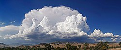
Atmospheric instability is a condition where the Earth's atmosphere is considered to be unstable and as a result local weather is highly variable through distance and time.[ clarification needed ] [1] Atmospheric stability is a measure of the atmosphere's tendency to discourage vertical motion, and vertical motion is directly correlated to different types of weather systems and their severity. In unstable conditions, a lifted thing, such as a parcel of air will be warmer than the surrounding air. Because it is warmer, it is less dense and is prone to further ascent.

Contents

In meteorology, instability can be described by various indices such as the Bulk Richardson Number, lifted index, K-index, convective available potential energy (CAPE), the Showalter, and the Vertical totals. These indices, as well as atmospheric instability itself, involve temperature changes through the troposphere with height, or lapse rate. Effects of atmospheric instability in moist atmospheres include thunderstorm development, which over warm oceans can lead to tropical cyclogenesis, and turbulence. In dry atmospheres, inferior mirages, dust devils, steam devils, and fire whirls can form. Stable atmospheres can be associated with drizzle, fog, increased air pollution, a lack of turbulence, and undular bore formation.

Forms

Anvil shaped thundercloud in the mature stage over Swifts Creek, Victoria, Australia Anvil shaped cumulus panorama edit crop.jpg
Anvil shaped thundercloud in the mature stage over Swifts Creek, Victoria, Australia

There are two primary forms of atmospheric instability: [2]

Under convective instability thermal mixing through convection in the form of warm air rising leads to the development of clouds and possibly precipitation or convective storms. Dynamic instability is produced through the horizontal movement of air and the physical forces it is subjected to such as the Coriolis force and pressure gradient force. Dynamic lifting and mixing produces cloud, precipitation and storms often on a synoptic scale.

Cause of instability

Whether or not the atmosphere has stability depends partially on the moisture content. In a very dry troposphere, a temperature decrease with height less than 9.8C per kilometer ascent indicates stability, while greater changes indicate instability. This lapse rate is known as the dry adiabatic lapse rate. [3] In a completely moist troposphere, a temperature decrease with height less than 6C per kilometer ascent indicates stability, while greater changes indicate instability. In the range between 6C and 9.8C temperature decrease per kilometer ascent, the term conditionally unstable is used.

Indices used for its determination

Lifted Index

The lifted index (LI), usually expressed in kelvins, is the temperature difference between the temperature of the environment Te(p) and an air parcel lifted adiabatically Tp(p) at a given pressure height in the troposphere, usually 500 hPa (mb). When the value is positive, the atmosphere (at the respective height) is stable and when the value is negative, the atmosphere is unstable. Thunderstorms are expected with values below −2, and severe weather is anticipated with values below −6. [4]

K Index

K-index valueThunderstorm probability
Less than 20None
20 to 25Isolated thunderstorms
26 to 30Widely scattered thunderstorms
31 to 35Scattered thunderstorms
Above 35Numerous thunderstorms [5]

The K index is derived arithmetically: K-index = (850 hPa temperature – 500 hPa temperature) + 850 hPa dew point – 700 hPa dew point depression

CAPE and CIN

Conditions favorable for thunderstorm types and complexes CAPE vs SHEAR.svg
Conditions favorable for thunderstorm types and complexes

Convective available potential energy (CAPE), [6] sometimes, simply, available potential energy (APE), is the amount of energy a parcel of air would have if lifted a certain distance vertically through the atmosphere. CAPE is effectively the positive buoyancy of an air parcel and is an indicator of atmospheric instability, which makes it valuable in predicting severe weather. CIN, convective inhibition, is effectively negative buoyancy, expressed B-; the opposite of convective available potential energy (CAPE), which is expressed as B+ or simply B. As with CAPE, CIN is usually expressed in J/kg but may also be expressed as m2/s2, as the values are equivalent. In fact, CIN is sometimes referred to as negative buoyant energy (NBE).

It is a form of fluid instability found in thermally stratified atmospheres in which a colder fluid overlies a warmer one. When an air mass is unstable, the element of the air mass that is displaced upwards is accelerated by the pressure differential between the displaced air and the ambient air at the (higher) altitude to which it was displaced. This usually creates vertically developed clouds from convection, due to the rising motion, which can eventually lead to thunderstorms. It could also be created in other phenomenon, such as a cold front. Even if the air is cooler on the surface, there is still warmer air in the mid-levels, that can rise into the upper-levels. However, if there is not enough water vapor present, there is no ability for condensation, thus storms, clouds, and rain will not form.

Bulk Richardson Number

The Bulk Richardson Number (BRN) is a dimensionless number relating vertical stability and vertical wind shear (generally, stability divided by shear). It represents the ratio of thermally-produced turbulence and turbulence generated by vertical shear. Practically, its value determines whether convection is free or forced. High values indicate unstable and/or weakly sheared environments; low values indicate weak instability and/or strong vertical shear. Generally, values in the range of around 10 to 45 suggest environmental conditions favorable for supercell development.

Showalter index

The Showalter index is a dimensionless number computed by taking the temperature at the 850 hPa level which is then taken dry adiabatically up to saturation, then up to the 500 hPa level, which is then subtracted by the observed 500 hPa level temperature. If the value is negative, then the lower portion of the atmosphere is unstable, with thunderstorms expected when the value is below −3. [7] The application of the Showalter index is especially helpful when there is a cool, shallow air mass below 850 hPa that conceals the potential convective lifting. However, the index will underestimate the potential convective lifting if there are cool layers that extend above 850 hPa and it does not consider diurnal radiative changes or moisture below 850 hPa. [8]

Effects

Image of an undular bore wave Ondes de pression au-dessus de la Mer d'Arabie.jpg
Image of an undular bore wave

Stable atmosphere

Stable conditions, such as during a clear and calm night, will cause pollutants to become trapped near ground level. [9] Drizzle occurs within a moist air mass when it is stable. Air within a stable layer is not turbulent. [10] Conditions associated with a marine layer, a stable atmosphere common on the west side of continents near cold water currents, leads to overnight and morning fog. [11] Undular bores can form when a low level boundary such as a cold front or outflow boundary approaches a layer of cold, stable air. The approaching boundary will create a disturbance in the atmosphere producing a wave-like motion, known as a gravity wave. Although the undular bore waves appear as bands of clouds across the sky, they are transverse waves, and are propelled by the transfer of energy from an oncoming storm and are shaped by gravity. The ripple-like appearance of this wave is described as the disturbance in the water when a pebble is dropped into a pond or when a moving boat creates waves in the surrounding water. The object displaces the water or medium the wave is travelling through and the medium moves in an upward motion. However, because of gravity, the water or medium is pulled back down and the repetition of this cycle creates the transverse wave motion. [12]

Unstable atmosphere

Mirage over a hot road, with the appearance of "fake water" on its surface Hot road mirage.jpg
Mirage over a hot road, with the appearance of "fake water" on its surface

Within an unstable layer in the troposphere, the lifting of air parcels will occur, and continue for as long as the nearby atmosphere remains unstable. Once overturning through the depth of the troposphere occurs (with convection being capped by the relatively warmer, more stable layer of the stratosphere), deep convective currents lead to thunderstorm development when enough moisture is present. Over warm ocean waters and within a region of the troposphere with light vertical wind shear and significant low level spin (or vorticity), such thunderstorm activity can grow in coverage and develop into a tropical cyclone. [13] Over hot surfaces during warm days, unstable dry air can lead to significant refraction of the light within the air layer, which causes inferior mirages. [14]

When winds are light, dust devils can develop on dry days within a region of instability at ground level. [15] Small-scale, tornado-like circulations can occur over or near any intense surface heat source, which would have significant instability in its vicinity. Those that occur near intense wildfires are called fire whirls, which can spread a fire beyond its previous bounds. [16] A steam devil is a rotating updraft that involves steam or smoke. They can form from smoke issuing from a power plant smokestack. Hot springs and warm lakes are also suitable locations for a steam devil to form, when cold arctic air passes over the relatively warm water. [15]

See also

Related Research Articles

<span class="mw-page-title-main">Stratosphere</span> Layer of the atmosphere above the troposphere

The stratosphere is the second layer of the atmosphere of Earth, located above the troposphere and below the mesosphere. The stratosphere is an atmospheric layer composed of stratified temperature layers, with the warm layers of air high in the sky and the cool layers of air in the low sky, close to the planetary surface of the Earth. The increase of temperature with altitude is a result of the absorption of the Sun's ultraviolet (UV) radiation by the ozone layer. The temperature inversion is in contrast to the troposphere, and near the Earth's surface, where temperature decreases with altitude.

<span class="mw-page-title-main">Cloud</span> Visible mass of liquid droplets or frozen crystals suspended in the atmosphere

In meteorology, a cloud is an aerosol consisting of a visible mass of miniature liquid droplets, frozen crystals, or other particles suspended in the atmosphere of a planetary body or similar space. Water or various other chemicals may compose the droplets and crystals. On Earth, clouds are formed as a result of saturation of the air when it is cooled to its dew point, or when it gains sufficient moisture from an adjacent source to raise the dew point to the ambient temperature.

<span class="mw-page-title-main">Cumulonimbus cloud</span> Genus of dense, towering vertical clouds

Cumulonimbus is a dense, towering vertical cloud, typically forming from water vapor condensing in the lower troposphere that builds upward carried by powerful buoyant air currents. Above the lower portions of the cumulonimbus the water vapor becomes ice crystals, such as snow and graupel, the interaction of which can lead to hail and to lightning formation, respectively. When occurring as a thunderstorm these clouds may be referred to as thunderheads. Cumulonimbus can form alone, in clusters, or along squall lines. These clouds are capable of producing lightning and other dangerous severe weather, such as tornadoes, hazardous winds, and large hailstones. Cumulonimbus progress from overdeveloped cumulus congestus clouds and may further develop as part of a supercell. Cumulonimbus is abbreviated Cb.

<span class="mw-page-title-main">Inversion (meteorology)</span> Deviation from the normal change of an atmospheric property with altitude

In meteorology, an inversion is a deviation from the normal change of an atmospheric property with altitude. It almost always refers to an inversion of the air temperature lapse rate, in which case it is called a temperature inversion. Normally, air temperature decreases with an increase in altitude, but during an inversion warmer air is held above cooler air.

<span class="mw-page-title-main">Thunderstorm</span> Type of weather with lightning and thunder

A thunderstorm, also known as an electrical storm or a lightning storm, is a storm characterized by the presence of lightning and its acoustic effect on the Earth's atmosphere, known as thunder. Relatively weak thunderstorms are sometimes called thundershowers. Thunderstorms occur in a type of cloud known as a cumulonimbus. They are usually accompanied by strong winds and often produce heavy rain and sometimes snow, sleet, or hail, but some thunderstorms produce little precipitation or no precipitation at all. Thunderstorms may line up in a series or become a rainband, known as a squall line. Strong or severe thunderstorms include some of the most dangerous weather phenomena, including large hail, strong winds, and tornadoes. Some of the most persistent severe thunderstorms, known as supercells, rotate as do cyclones. While most thunderstorms move with the mean wind flow through the layer of the troposphere that they occupy, vertical wind shear sometimes causes a deviation in their course at a right angle to the wind shear direction.

<span class="mw-page-title-main">Lapse rate</span> Vertical rate of change of temperature in atmosphere

The lapse rate is the rate at which an atmospheric variable, normally temperature in Earth's atmosphere, falls with altitude. Lapse rate arises from the word lapse, in the sense of a gradual fall. In dry air, the adiabatic lapse rate is 9.8 °C/km. The saturated adiabatic lapse rate (SALR), or moist adiabatic lapse rate (MALR), is the decrease in temperature of a parcel of water-saturated air that rises in the atmosphere. It varies with the temperature and pressure of the parcel and is often in the range 3.6 to 9.2 °C/km, as obtained from the International Civil Aviation Organization (ICAO). The environmental lapse rate is the decrease in temperature of air with altitude for a specific time and place. It can be highly variable between circumstances.

Equivalent potential temperature, commonly referred to as theta-e, is a quantity that is conserved during changes to an air parcel's pressure, even if water vapor condenses during that pressure change. It is therefore more conserved than the ordinary potential temperature, which remains constant only for unsaturated vertical motions.

<span class="mw-page-title-main">Thermal</span> Column of rising air in the lower altitudes of Earths atmosphere

A thermal column is a rising mass of buoyant air, a convective current in the atmosphere, that transfers heat energy vertically. Thermals are created by the uneven heating of Earth's surface from solar radiation, and are an example of convection, specifically atmospheric convection.

<span class="mw-page-title-main">Cloud physics</span> Study of the physical processes in atmospheric clouds

Cloud physics is the study of the physical processes that lead to the formation, growth and precipitation of atmospheric clouds. These aerosols are found in the troposphere, stratosphere, and mesosphere, which collectively make up the greatest part of the homosphere. Clouds consist of microscopic droplets of liquid water, tiny crystals of ice, or both, along with microscopic particles of dust, smoke, or other matter, known as condensation nuclei. Cloud droplets initially form by the condensation of water vapor onto condensation nuclei when the supersaturation of air exceeds a critical value according to Köhler theory. Cloud condensation nuclei are necessary for cloud droplets formation because of the Kelvin effect, which describes the change in saturation vapor pressure due to a curved surface. At small radii, the amount of supersaturation needed for condensation to occur is so large, that it does not happen naturally. Raoult's law describes how the vapor pressure is dependent on the amount of solute in a solution. At high concentrations, when the cloud droplets are small, the supersaturation required is smaller than without the presence of a nucleus.

<span class="mw-page-title-main">Convective available potential energy</span> Measure of instability in the air as a buoyancy force

In meteorology, convective available potential energy, is the integrated amount of work that the upward (positive) buoyancy force would perform on a given mass of air if it rose vertically through the entire atmosphere. Positive CAPE will cause the air parcel to rise, while negative CAPE will cause the air parcel to sink. Nonzero CAPE is an indicator of atmospheric instability in any given atmospheric sounding, a necessary condition for the development of cumulus and cumulonimbus clouds with attendant severe weather hazards.

<span class="mw-page-title-main">Cyclogenesis</span> The development or strengthening of cyclonic circulation in the atmosphere

Cyclogenesis is the development or strengthening of cyclonic circulation in the atmosphere. Cyclogenesis is an umbrella term for at least three different processes, all of which result in the development of some sort of cyclone, and at any size from the microscale to the synoptic scale.

<span class="mw-page-title-main">Convective inhibition</span> Measure in meteorology

Convective inhibition is a numerical measure in meteorology that indicates the amount of energy that will prevent an air parcel from rising from the surface to the level of free convection.

<span class="mw-page-title-main">Mesoscale convective system</span> Complex of thunderstorms organized on a larger scale

A mesoscale convective system (MCS) is a complex of thunderstorms that becomes organized on a scale larger than the individual thunderstorms but smaller than extratropical cyclones, and normally persists for several hours or more. A mesoscale convective system's overall cloud and precipitation pattern may be round or linear in shape, and include weather systems such as tropical cyclones, squall lines, lake-effect snow events, polar lows, and mesoscale convective complexes (MCCs), and generally forms near weather fronts. The type that forms during the warm season over land has been noted across North and South America, Europe, and Asia, with a maximum in activity noted during the late afternoon and evening hours.

<span class="mw-page-title-main">Convective instability</span> Ability of an air mass to resist vertical motion

In meteorology, convective instability or stability of an air mass refers to its ability to resist vertical motion. A stable atmosphere makes vertical movement difficult, and small vertical disturbances dampen out and disappear. In an unstable atmosphere, vertical air movements tend to become larger, resulting in turbulent airflow and convective activity. Instability can lead to significant turbulence, extensive vertical clouds, and severe weather such as thunderstorms.

<span class="mw-page-title-main">Air-mass thunderstorm</span> Thunderstorm that is generally weak and usually not severe

An air-mass thunderstorm, also called an "ordinary", "single cell", "isolated" or "garden variety" thunderstorm, is a thunderstorm that is generally weak and usually not severe. These storms form in environments where at least some amount of Convective Available Potential Energy (CAPE) is present, but with very low levels of wind shear and helicity. The lifting source, which is a crucial factor in thunderstorm development, is usually the result of uneven heating of the surface, though they can be induced by weather fronts and other low-level boundaries associated with wind convergence. The energy needed for these storms to form comes in the form of insolation, or solar radiation. Air-mass thunderstorms do not move quickly, last no longer than an hour, and have the threats of lightning, as well as showery light, moderate, or heavy rainfall. Heavy rainfall can interfere with microwave transmissions within the atmosphere.

<span class="mw-page-title-main">Lifted index</span>

The lifted index (LI) is the temperature difference between the environment Te(p) and an air parcel lifted adiabatically Tp(p) at a given pressure height in the troposphere of the atmosphere, usually 500 hPa (mb). The temperature is measured in Celsius. When the value is positive, the atmosphere is stable and when the value is negative, the atmosphere is unstable.

<span class="mw-page-title-main">Free convective layer</span>

In atmospheric sciences, the free convective layer (FCL) is the layer of conditional or potential instability in the troposphere. It is a layer in which rising air can experience positive buoyancy (PBE) so that deep, moist convection (DMC) can occur. On an atmospheric sounding, it is the layer between the level of free convection (LFC) and the equilibrium level (EL). The FCL is important to a variety of convective processes and to severe thunderstorm forecasting.

<span class="mw-page-title-main">Atmospheric convection</span> Atmospheric phenomenon

Atmospheric convection is the result of a parcel-environment instability in the atmosphere. Different lapse rates within dry and moist air masses lead to instability. Mixing of air during the day expands the height of the planetary boundary layer, leading to increased winds, cumulus cloud development, and decreased surface dew points. Convection involving moist air masses leads to thunderstorm development, which is often responsible for severe weather throughout the world. Special threats from thunderstorms include hail, downbursts, and tornadoes.

The following is a glossary of tornado terms. It includes scientific as well as selected informal terminology.

<span class="mw-page-title-main">Glossary of meteorology</span> List of definitions of terms and concepts commonly used in meteorology

This glossary of meteorology is a list of terms and concepts relevant to meteorology and atmospheric science, their sub-disciplines, and related fields.

References

  1. Stability of Air Archived February 9, 2008, at the Wayback Machine
  2. Explanation of Atmospheric Stability/Instability - by Steve W. Woodruff Archived June 12, 2008, at the Wayback Machine
  3. John E. Oliver (2005). Encyclopedia of world climatology. Springer. p. 449. ISBN   978-1-4020-3264-6.
  4. 1 2 Edward Aguado & James E. Burt (2007). Understanding weather and climate. Pearson Prentice Hall. pp. 416–418. ISBN   978-0-13-149696-5.
  5. National Weather Service Forecast Office, Detroit, Michigan (2010-01-25). Gloassary: K. Archived 2012-11-30 at the Wayback Machine National Weather Service Central Region Headquarters. Retrieved on 2011-02-24
  6. M. W. Moncrieff; M.J. Miller (1976). "The dynamics and simulation of tropical cumulonimbus and squall lines". Q. J. R. Meteorol. Soc. 120 (432): 373–94. Bibcode:1976QJRMS.102..373M. doi:10.1002/qj.49710243208. Archived from the original (abstract) on 2012-12-16.
  7. Rattan K. Datta (1996). Advances in tropical meteorology: meteorology and national development: proceedings of the National Symposium TROPMET-93 organised by the Indian Meteorological Society at New Delhi from March 17–19, 1993 with the theme "meteorology and national development". Concept Publishing Company. p. 347. ISBN   978-81-7022-532-4.
  8. "NOAA's National Weather Service - Glossary". NOAA.
  9. Dennis A. Snow (2003-01-01). Plant Engineer's Reference Book. Butterworth-Heinemann. pp. 28/8–28/10. ISBN   978-0-7506-4452-5.
  10. Phil Croucher (2004-03-01). Jar professional pilot studies. Lulu.com. pp. 8–29. ISBN   978-0-9681928-2-5.
  11. National Weather Service Office, Oxnard, California (2012). "Climate of Los Angeles". National Weather Service Western Region Headquarters. Retrieved 2012-02-16.{{cite web}}: CS1 maint: multiple names: authors list (link)
  12. Martin Setvak; Jochen Kerkmann; Alexander Jacob; HansPeter Roesli; Stefano Gallino & Daniel Lindsey (2007-03-19). "Outflow from convective storm, Mauritania and adjacent Atlantic Ocean (13 August 2006)" (PDF). Agenzia Regionale per la Protezione dell'Ambiente Ligure. Archived from the original (PDF) on 25 July 2011. Retrieved 2009-07-03.
  13. Chris Landsea. "How do tropical cyclones form?". Frequently Asked Questions: Hurricanes, Typhoons and Tropical Cyclones. Atlantic Oceanographic and Meteorological Laboratory. Archived from the original on 2009-08-27. Retrieved 2006-07-25.
  14. Michael Vollmer (March 2009). "Mirrors in the air: mirages in nature and in the laboratory". Physics Education. 44 (2): 167. Bibcode:2009PhyEd..44..165V. doi:10.1088/0031-9120/44/2/008. S2CID   121672201.
  15. 1 2 David McWilliams Ludlum (1991-10-15). National Audubon Society field guide to North American weather. Random House Digital, Inc. pp. 520–523. ISBN   978-0-679-40851-2.
  16. Stephen J. Pyne; Patricia L. Andrews & Richard D. Laven (1996-04-26). Introduction to wildland fire. Vol. 86. John Wiley and Sons. p. 77. Bibcode:1997AgFM...86..140U. doi:10.1016/S0168-1923(97)00032-4. ISBN   978-0-471-54913-0.{{cite book}}: |journal= ignored (help)