Battenberg (Eder)

Last updated
Battenberg
Battenberg eder bergfried blick vom tal hinauf zur altstadt ds wv 09 2005.jpg
Oberstadt (Upper Town) with Neuburg (New Castle)
Wappen Battenberg Eder.svg
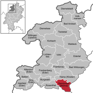
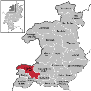
Location of Battenberg within Waldeck-Frankenberg district
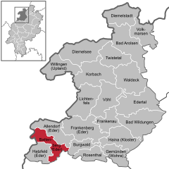
Battenberg (Eder) in KB.svgBattenbergRosenthalFrankenbergLichtenfelsDiemelseeWaldeck
Germany adm location map.svg
Red pog.svg
Battenberg
Hesse location map.svg
Red pog.svg
Battenberg
Coordinates: 51°01′N08°39′E / 51.017°N 8.650°E / 51.017; 8.650
Country Germany
State Hesse
Admin. region Kassel
District Waldeck-Frankenberg
Subdivisions4 Ortsteile
Government
   Mayor (202026) Christian Klein [1]
Area
  Total64.73 km2 (24.99 sq mi)
Elevation
340 m (1,120 ft)
Population
 (2022-12-31) [2]
  Total5,500
  Density85/km2 (220/sq mi)
Time zone UTC+01:00 (CET)
  Summer (DST) UTC+02:00 (CEST)
Postal codes
35088
Dialling codes 06452
Vehicle registration KB
Website www.battenberg-eder.de

Battenberg (Eder) is a small town in the district of Waldeck-Frankenberg in the state of Hesse, Germany. It is located on the river Eder, a tributary of the Fulda, which flows into the Weser, and lies at the southeastern edges of the Rothaar Mountains. The closest larger cities are Marburg, Siegen, and Kassel, and the town is approximately equally far away from Frankfurt am Main, Cologne, and Dortmund.

Contents

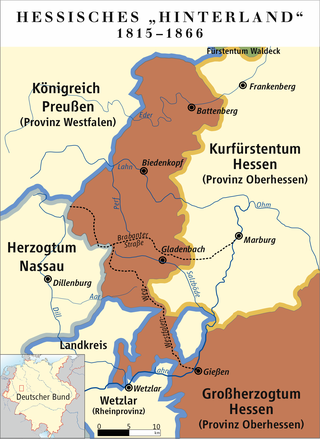
In 1624, Battenberg was incorporated into the Landgraviate of Hesse-Darmstadt (since 1806 the Grand Duchy of Hesse) as part of the so called Hessian Hinterland, an almost-exclave, which was connected to Upper Hesse (de) only through a tiny corridor west of Gießen. The "Hinterland" was annexed by the Kingdom of Prussia in 1866, and merged with the territories of the former Duchy of Nassau, to form the Province of Hesse-Nassau in 1868. From 1918 on, the town lay in the Free State of Prussia, and since 1945, it is in the federal state of Hesse.

Battenberg is the origin of the medieval House of Battenberg (de), which was not related to the House of Hesse and ruled over the County of Battenberg (de) until it died out in 1310, and of the Battenberg family (in German called the "Haus Battenberg" = "House of Battenberg"), a morganatic branch of the Hesse-Darmstadt branch of the House of Hesse, which ruled over, among others, the Landgraviate of Hesse-Darmstadt (later the Grand Duchy of Hesse) until 1918, and the Landgraviate of Hesse-Kassel (later the Electorate of Hesse) until its annexation by Prussia in 1866. The literal translation of Battenberg, "Mountbatten" (Berg = mountain), is used by members of the British royal family.

The Battenberg cake and hence also the Battenburg markings both indirectly derive their name from the town.

View from the upper town (Oberstadt) down into the Eder valley Battenberg eder talblick von der altstadt ds wv 09 2005.jpg
View from the upper town (Oberstadt) down into the Eder valley
"Neuburg" (New Castle) (de:Neuburg (Battenberg)), sometimes also called "Schloss Battenberg" (Battenberg Palace) Battenberg (3).JPG
"Neuburg" (New Castle) (de:Neuburg (Battenberg)), sometimes also called "Schloss Battenberg" (Battenberg Palace)
View from the ruin of the Kellerburg (de:Kellerburg) Bergfried Kellerburg-06-Aussicht SW.jpg
View from the ruin of the Kellerburg (de:Kellerburg)
Church of Battenberg-Frohnhausen (de:Frohnhausen (Battenberg)) Kirche Frohnhausen (Battenberg) 01.jpg
Church of Battenberg-Frohnhausen (de:Frohnhausen (Battenberg))

Geography

Location

The centre of Battenberg lies in the Ederbergland, or Eder Highland, to which the Burgwald abutting the town to the east also belongs, on the southern edge of the Sauerland and the Rothaargebirge. Lying between 320 and 650 m above sea level, the town is also crossed by the river Eder.

Neighbouring communities

Battenberg borders in the north on the community of Bromskirchen, in the northeast on the community of Allendorf, in the southeast on the community of Burgwald (all three in Waldeck-Frankenberg), in the south on the community of Münchhausen am Christenberg (Marburg-Biedenkopf), and in the west on the towns of Hatzfeld (Waldeck-Frankenberg) and Bad Berleburg (Siegen-Wittgenstein in North Rhine-Westphalia).

Incorporated villages

Battenberg consists of:

and the incorporated villages of:

Right next to Battenberg proper on the western side of the Eder is Battenfeld (de:Battenfeld), a district of the neighbouring town of Allendorf (Eder).

History

In 778 fighting took place near Laisa and Battenfeld as part of Charlemagne's Saxon Wars. A branch of the Wittgenstein noble family began calling themselves the "Counts of Battenberg" in 1214 – compare Sayn-Wittgenstein. In 1232, Battenberg had its first documentary mention, and two years later it was granted town rights. The early-Gothic church dates from 1249. In 1297, the town's ownership was transferred to the Archbishops of Mainz. In 1464, the Amt of Battenberg passed to Hesse. In 1932, Battenberg became part of the Frankenberg/Eder district. As part of municipal reform in 1974, the districts of Frankenberg (including Battenberg) and Waldeck united to form the district of Waldeck-Frankenberg.

The dynasty of the counts of Battenberg ceased to exist in 1314, their castle was demolished throughout the following centuries. When Prince Alexander von Hessen-Darmstadt, the brother of the grand duke of Hesse, married Julia von Hauke, the orphaned daughter of the former Deputy Minister of War [3] of Congress Poland, their liaison was not considered befitting of his rank. Therefore her brother-in-law made her countess of Battenberg in 1851 and princess of Battenberg in 1858. With her husband, who agreed to carry the same title and name, she lived near Seeheim-Jugenheim at "Schloss Heiligenberg", a re-modelled manor. Her sons Ludwig Alexander and Heinrich Moritz both served the British empire, their families anglicized their name to Mountbatten (Berg means "mountain, hill" in German) in 1917.

Population development

31 December 1988 : 5,099 inhabitants
31 December 1991 : 5,602 inhabitants
31 December 1995 : 5,693 inhabitants
31 December 2000 : 5,752 inhabitants
31 December 2004 : 5,701 inhabitants

Politics

Town council

Municipal elections held on 6 March 2016 apportioned the town council's 31 seats thus:

Party nameNumber of seats
CDU 6 seats
SPD 6 seats
Bürgerliste Stadt Battenberg6 seats
Bürgerliste der Stadtteile Laisa, Frohnhausen und Berghofen6 seats
Bürgerliste Dodenau5 seats
FDP 2 seats

Note: Bürgerlisten are "citizens' lists", not actual political parties.

Coat of arms

Battenberg's civic coat of arms might heraldically be described thus: Per pale sable and argent.

The tinctures come from the arms borne by the town's old overlords, the Counts of Battenberg(a branch of the Counts of Wittgenstein). Battenberg's arms have their roots in the 13th century, putting them among Hesse's oldest municipal coats of arms.

Various other charges have appeared in the arms over the centuries, however. Sometimes it was a tower, the Count of Battenberg and the Archbishop of Mainz, the Archbishop by himself, or the Wheel of Mainz. One version even showed the same simple composition seen here, but with gules (red) instead of sable (black). This would have made the arms identical to those currently borne by Buchloe in Bavaria.

Town partnerships

Adoption

Notable people

Related Research Articles

Marburg-Biedenkopf is a Kreis (district) in the west of Hesse, Germany. Neighboring districts are Waldeck-Frankenberg, Schwalm-Eder, Vogelsbergkreis, Gießen, Lahn-Dill, Siegen-Wittgenstein.

Waldeck-Frankenberg is a Kreis (district) in the north of Hesse, Germany. Neighbouring districts are Höxter, Kassel, Schwalm-Eder, Marburg-Biedenkopf, Siegen-Wittgenstein, Hochsauerland.

<span class="mw-page-title-main">House of Hesse</span> European noble house originating from Hesse, Germany

The House of Hesse is a European dynasty, directly descended from the House of Brabant. They ruled the region of Hesse, one branch as prince-electors until 1866, and another branch as grand dukes until 1918.

<span class="mw-page-title-main">Rauschenberg, Hesse</span> Town in Hesse, Germany

Rauschenberg is a town in the north of Marburg-Biedenkopf district in Hesse, Germany.

<span class="mw-page-title-main">Hatzfeld</span> Town in Hesse, Germany

Hatzfeld (Eder) is a small town in Waldeck-Frankenberg district in Hesse, Germany.

<span class="mw-page-title-main">Schwalm-Eder</span> Federal electoral district of Germany

Schwalm-Eder is an electoral constituency represented in the Bundestag. It elects one member via first-past-the-post voting. Under the current constituency numbering system, it is designated as constituency 170. It is located in northern Hesse, comprising the Schwalm-Eder-Kreis district and the southern part of the Waldeck-Frankenberg district.

<span class="mw-page-title-main">Frankenberg, Hesse</span> Town in Hesse, Germany

Frankenberg an der Eder is a town in Waldeck-Frankenberg district, Hesse, Germany.

<span class="mw-page-title-main">Gemünden (Wohra)</span> Town in Hesse, Germany

Gemünden is a town in Waldeck-Frankenberg district in Hesse, Germany.

<span class="mw-page-title-main">Allendorf (Eder)</span> Municipality in Hesse, Germany

Allendorf (Eder) (German:[ˈaləndɔʁf] ) is a municipality which situated in the north west of Hesse, Germany. The municipality is within the Waldeck-Frankenberg district in a rural region called the upper Eder Valley. The Burgwald range is located west of Allendorf while the Breite Struth hills are in Allendorf's east.

<span class="mw-page-title-main">Bromskirchen</span> Borough of Allendorf in Hesse, Germany

Bromskirchen is a village and a former municipality in Waldeck-Frankenberg in Hesse, Germany. On 1 January 2023, it was merged into the municipality of Allendorf (Eder).

<span class="mw-page-title-main">Burgwald</span> Municipality in Hesse, Germany

Burgwald is a municipality in Waldeck-Frankenberg in Hesse, Germany.

<span class="mw-page-title-main">Vöhl</span> Municipality in Hesse, Germany

Vöhl is a municipality in Waldeck-Frankenberg in Hesse, Germany, not far southwest of Kassel.

<span class="mw-page-title-main">Landgraviate of Hesse-Darmstadt</span> State of the Holy Roman Empire (1567–1806)

The Landgraviate of Hesse-Darmstadt was a State of the Holy Roman Empire, ruled by a younger branch of the House of Hesse. It was formed in 1567 following the division of the Landgraviate of Hesse between the four sons of Landgrave Philip I.

<span class="mw-page-title-main">West Hesse Highlands</span>

The West Hesse Highlands, also known as the West Hessian Lowlands and Highlands, are a heavily forested region of the Central Uplands in Germany. These highlands lie mainly within the state of Hesse, between that part of the Rhenish Massif right of the Rhine in the west, the Weser Uplands to the north, the Hessian Central Uplands to the east and the Wetterau to the south.

<span class="mw-page-title-main">Waldeck (electoral district)</span> German Bundestag constituency

Waldeck is an electoral constituency represented in the Bundestag. It elects one member via first-past-the-post voting. Under the current constituency numbering system, it is designated as constituency 167. It is located in northern Hesse, comprising most of the Landkreis Kassel district and the northern part of the Waldeck-Frankenberg district.

The Eder Uplands refers to a region in North Hesse in Germany. It covers several municipalities that lies around the upper reaches of the Eder river on the edge of the Rothaar Mountains. The Eder Uplands includes a large part of the old county of Frankenberg, which was absorbed into Waldeck-Frankenberg in the wake of the administrative reforms.

<span class="mw-page-title-main">Hessian Hinterland</span>

The land known as the Hessian Hinterland lies within the region of Middle Hesse and is concentrated around the old county of Biedenkopf, that is the western part of the present county of Marburg-Biedenkopf, as well as elements of the present-day counties of Lahn-Dill-Kreis and Waldeck-Frankenberg. Formerly it snaked its way from Bromskirchen in the north to Rodheim, in the municipality of Biebertal.

<span class="mw-page-title-main">Warburg–Sarnau railway</span>

The Warburg–Sarnau railway is a 100.9 kilometre-long, single-track, partially disused secondary railway line in North Rhine-Westphalia and North Hesse. The middle section, Korbach–Frankenberg, is called the Untere Edertalbahn or the Nationalparkbahn and the southern section, Frankenberg–Sarnau(–Marburg), is called the Burgwaldbahn.

References

  1. "Ergebnisse der letzten Direktwahl aller hessischen Landkreise und Gemeinden" (XLS) (in German). Hessisches Statistisches Landesamt. 5 September 2022.
  2. "Bevölkerung in Hessen am 31.12.2022 nach Gemeinden" (XLS) (in German). Hessisches Statistisches Landesamt. June 2023.
  3. Danielewicz, Jerzy (1954). Generał Ignacy Pradzyński, 1792-1850 [Generał Ignacy Pradzyński, 1792-1850] (in Polish). Warsaw: Ministerstwo Obrony Narodowej. p. 34. Retrieved 21 March 2010. Zastępca ministra wojny gen. Maurycy hr. Hauke[...] [Translation: The Deputy Minister of War, General Count Maurice Hauke ...