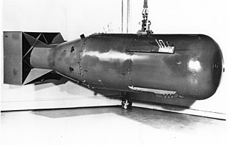
Little Boy was the name of the type of atomic bomb used in the bombing of the Japanese city of Hiroshima on 6 August 1945 during World War II, making it the first nuclear weapon used in warfare. The bomb was dropped by the Boeing B-29 Superfortress Enola Gay piloted by Colonel Paul W. Tibbets Jr., commander of the 509th Composite Group, and Captain Robert A. Lewis. It exploded with an energy of approximately 15 kilotons of TNT (63 TJ) and had an explosion radius of approximately 1.3 kilometers which caused widespread death across the city. The Hiroshima bombing was the second nuclear explosion in history, after the Trinity nuclear test.

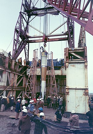
Trinity was the code name of the first detonation of a nuclear weapon, conducted by the United States Army at 5:29 a.m. MWT on July 16, 1945, as part of the Manhattan Project. The test was of an implosion-design plutonium bomb, nicknamed the "gadget", of the same design as the Fat Man bomb later detonated over Nagasaki, Japan, on August 9, 1945. Concerns about whether the complex Fat Man design would work led to a decision to conduct the first nuclear test. The code name "Trinity" was assigned by J. Robert Oppenheimer, the director of the Los Alamos Laboratory, inspired by the poetry of John Donne.

Lamar County is a county located in the U.S. state of Mississippi. As of the 2020 census, the population was 64,222. Its county seat is Purvis. Named for Confederate Lucius Quintus Cincinnatus Lamar, the county was carved out of Marion County to the west in 1904.
Purvis is a U.S. city in and the county seat of Lamar County, Mississippi. It is part of the Hattiesburg, Mississippi Metropolitan Statistical Area. The population was 2,175 at the 2010 census. The Town of Purvis was incorporated on February 25, 1888 and was founded by and named after Thomas Melville Purves, originally of Marion County, Alabama. Purves, born March 8, 1820, was a second generation Scottish-American; his grandfather emigrated to Charleston, South Carolina in 1765.

West Hattiesburg is an unincorporated area and census-designated place (CDP) in Lamar County, Mississippi, west of the city of Hattiesburg and east of the community of Oak Grove. It is part of the Hattiesburg metropolitan area. It had a decline in population from 6,305 at the 2000 census to 5,909 at the 2010 census.

Hattiesburg is the 5th most populous city in the U.S. state of Mississippi, located primarily in Forrest County and extending west into Lamar County. The city population was 45,989 at the 2010 census, with the population now being 48,730 in 2020. Hattiesburg is the principal city of the Hattiesburg Metropolitan Statistical Area, which encompasses Covington, Forrest, Lamar, and Perry counties. The city is located in the Pine Belt region.

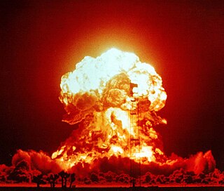
Nuclear weapons tests are experiments carried out to determine the performance, yield, and effects of nuclear weapons. Testing nuclear weapons offers practical information about how the weapons function, how detonations are affected by different conditions, and how personnel, structures, and equipment are affected when subjected to nuclear explosions. However, nuclear testing has often been used as an indicator of scientific and military strength. Many tests have been overtly political in their intention; most nuclear weapons states publicly declared their nuclear status through a nuclear test.

Operation Upshot–Knothole was a series of eleven nuclear test shots conducted in 1953 at the Nevada Test Site. It followed Operation Ivy and preceded Operation Castle.
Amchitka is a volcanic, tectonically unstable and uninhabited island in the Rat Islands group of the Aleutian Islands in southwest Alaska. It is part of the Alaska Maritime National Wildlife Refuge. The island, with a land area of roughly 116 square miles (300 km2), is about 42 miles (68 km) long and 1 to 4 miles wide. The area has a maritime climate, with many storms, and mostly overcast skies.
Project PACER, carried out at Los Alamos National Laboratory (LANL) in the mid-1970s, explored the possibility of a fusion power system that would involve exploding small hydrogen bombs —or, as stated in a later proposal, fission bombs—inside an underground cavity. Its proponents claimed that the system is the only fusion power system that could be demonstrated to work using existing technology. It would also require a continuous supply of nuclear explosives and contemporary economics studies demonstrated that these could not be produced at a competitive price compared to conventional energy sources.

Operation Hardtack I was a series of 35 nuclear tests conducted by the United States from April 28 to August 18 in 1958 at the Pacific Proving Grounds. At the time of testing, the Operation Hardtack I test series included more nuclear detonations than the total of prior nuclear explosions in the Pacific Ocean. These tests followed the Project 58/58A series, which occurred from 1957 December 6 to 1958, March 14, and preceded the Operation Argus series, which took place in 1958 from August 27 to September 6.
Peaceful nuclear explosions (PNEs) are nuclear explosions conducted for non-military purposes. Proposed uses include excavation for the building of canals and harbours, electrical generation, the use of nuclear explosions to drive spacecraft, and as a form of wide-area fracking. PNEs were an area of some research from the late 1950s into the 1980s, primarily in the United States and Soviet Union.
A nuclear explosion is an explosion that occurs as a result of the rapid release of energy from a high-speed nuclear reaction. The driving reaction may be nuclear fission or nuclear fusion or a multi-stage cascading combination of the two, though to date all fusion-based weapons have used a fission device to initiate fusion, and a pure fusion weapon remains a hypothetical device. Nuclear explosions are used in nuclear weapons and nuclear testing.

Atomic tourism or nuclear tourism is a recent form of tourism in which visitors learn about the Atomic Age by traveling to significant sites in atomic history such as nuclear test reactors, museums with nuclear weapon artifacts, delivery vehicles, sites where atomic weapons were detonated, and nuclear power plants.

Project Gnome was the first nuclear test of Project Plowshare and was the first continental nuclear weapon test since Trinity to be conducted outside of the Nevada Test Site, and the second test in the state of New Mexico after Trinity. It was tested in southeastern New Mexico on December 10, 1961, approximately 40 km southeast of Carlsbad, New Mexico.
The Hattiesburg Metropolitan Statistical Area is a metropolitan statistical area (MSA) in southeastern Mississippi that covers three counties - Forrest, Lamar, and Perry. The MSA's principal city is Hattiesburg. The 2010 census placed the Hattiesburg MSA's population at 162,410, though estimates as of 2019 indicate the population has increased to 168,849. The area is part of the geographical region known as the Pine Belt, famous for its abundance of longleaf pine trees. The Hattiesburg MSA is part of the larger Hattiesburg-Laurel Combined Statistical Area.

The Salmon Site is a 1,470-acre (5.9 km2) tract of land in Lamar County, Mississippi, near Baxterville. The tract is located over a geological formation known as the Tatum Salt Dome and is the location of the only nuclear weapons test detonations known to have been performed in the eastern United States.

Operation Sailor Hat was a series of explosives effects tests, conducted by the United States Navy Bureau of Ships under the sponsorship of the Defense Atomic Support Agency. The tests consisted of two underwater explosions at San Clemente Island, California in 1964 and three surface explosions at Kahoʻolawe, Hawaii in 1965. They were non-nuclear tests employing large quantities of conventional explosives to determine the effects of a nuclear weapon blast on naval vessels, and the first major test of this kind since Operation Crossroads in July 1946.

Frenchman Flat is a hydrographic basin in the Nevada National Security Site south of Yucca Flat and north of Mercury, Nevada. The flat was used as an American nuclear test site and has a 5.8 sq mi (15 km2) dry lake bed that was used as a 1950s airstrip before it was chosen after the start of the Korean War for the Nevada Proving Grounds. Nellis Air Force Base land 12 mi × 30 mi was transferred to the Atomic Energy Commission on which Site Mercury was constructed on the flat for supporting American nuclear explosive tests. The 1951 Operation Ranger "Able" test was the first continental US nuclear detonation after the 1945 Trinity test, and Frenchman Flat also had the only detonation of an American artillery-fired nuclear projectile in the 1953 Upshot-Knothole Grable test using the M65 Atomic Cannon.

Project Gasbuggy was an underground nuclear detonation carried out by the United States Atomic Energy Commission on December 10, 1967 in rural northern New Mexico. It was part of Operation Plowshare, a program designed to find peaceful uses for nuclear explosions.


