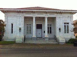
Lamar County is a county located in the U.S. state of Mississippi. As of the 2010 census, the population was 55,658. Its county seat is Purvis. Named for Confederate Lucius Quintus Cincinnatus Lamar, the county was carved out of Marion County to the west in 1904.

Forrest County is located in the U.S. state of Mississippi. As of the 2010 census, the population was 74,934. Its county seat and largest city is Hattiesburg. The county was created from Perry County in 1908 and named in honor of Nathan Bedford Forrest, a Confederate general in the American Civil War and the first Grand Wizard of the Ku Klux Klan. Forrest County is part of the Hattiesburg, MS Metropolitan Statistical Area.

Hattiesburg is a city in the U.S. state of Mississippi, located primarily in Forrest County and extending west into Lamar County. The city population was 45,989 at the 2010 census, with the population now being 48,730 in 2020. Hattiesburg is the principal city of the Hattiesburg Metropolitan Statistical Area, which encompasses Covington, Forrest, Lamar, and Perry counties. The city is located in the Pine Belt region.

Hurricane Katrina's winds and storm surge reached the Mississippi coastline on the morning of August 29, 2005. beginning a two-day path of destruction through central Mississippi; by 10 a.m. CDT on August 29, 2005, the eye of Katrina began traveling up the entire state, only slowing from hurricane-force winds at Meridian near 7 p.m. and entering Tennessee as a tropical storm. Many coastal towns of Mississippi had already been obliterated, in a single night. Hurricane-force winds reached coastal Mississippi by 2 a.m. and lasted over 17 hours, spawning 11 tornadoes and a 28-foot storm surge flooding 6–12 miles (10–19 km) inland. Many, unable to evacuate, survived by climbing to attics or rooftops, or swimming to higher buildings and trees. The worst property damage from Katrina occurred in coastal Mississippi, where all towns flooded over 90% in hours, and waves destroyed many historic buildings, with others gutted to the 3rd story. Afterward, 238 people died in Mississippi, and all counties in Mississippi were declared disaster areas, 49 for full federal assistance. Regulations were changed later for emergency centers and casinos. The emergency command centers were moved higher because all 3 coastal centers flooded at 30 ft (9 m) above sea level. Casinos were allowed on land rather than limited to floating casino barges as in 2005.

Mississippi Highway 42 is a state highway in southern Mississippi. MS 42 runs in an east/west direction for 116.0 miles (186.7 km), serving seven Mississippi counties: Wayne, Greene, Perry, Forrest, Lamar, Jefferson Davis, and Lawrence. Portions of this highway run parallel to the Longleaf Trace. The length of highway between Interstate 59 and U.S. Highway 11 in Forrest County, just outside Petal is known as the Evelyn Gandy Parkway.

The Pascagoula River is a river, about 80 miles (130 km) long, in southeastern Mississippi in the United States. The river drains an area of about 8,800 square miles (23,000 km²) and flows into Mississippi Sound of the Gulf of Mexico. The Pascagoula River Basin is managed by the Pat Harrison Waterway District.

The Leaf River is a river, about 180 mi (290 km) long, in southern Mississippi in the United States. It is a principal tributary of the Pascagoula River, which flows to the Gulf of Mexico.

WLOX is a television station licensed to Biloxi, Mississippi, United States, serving the Mississippi Gulf Coast as an affiliate of ABC and CBS. Owned by Gray Television, the station maintains studios on DeBuys Road in Biloxi, and its transmitter is located in unincorporated southern Stone County near McHenry.

WDAM-TV is a television station licensed to Laurel, Mississippi, United States, serving the Hattiesburg area as an affiliate of NBC and ABC. Owned by Gray Television, the station maintains studios and transmitter facilities on US 11 in unincorporated Moselle in southern Jones County.

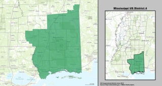
Mississippi's 4th congressional district covers the southeastern region of the state. It includes all of Mississippi's Gulf Coast, stretching ninety miles between the Alabama border to the east and the Louisiana border to the west, and extends north into the Pine Belt region. It includes three of Mississippi's four most heavily populated cities: Gulfport, Biloxi, and Hattiesburg. Other major cities within the district include Bay St. Louis, Laurel, and Pascagoula.

The Pine Belt, also known as the Piney Woods, is a region in Southeast Mississippi. The region gets its name from the longleaf pine trees that are abundant in the region. The Pine Belt includes 9 counties: Covington, Forrest, Greene, Jefferson Davis, Jones, Lamar, Marion, Perry, and Wayne.
The Lamar County School District (LCSD) is a public school district based in Purvis, Mississippi (USA).
The Lumberton Public School District was a public school district based in Lumberton, Mississippi, United States.
Baxterville is a census-designated place and unincorporated community in Lamar County, Mississippi. It is located in the southwestern portion of Lamar County along Mississippi Highway 13, southwest of Hattiesburg.

Flint Creek Water Park, located in Wiggins, Mississippi, is part of the Pat Harrison Waterway District, which is a Mississippi State Agency providing outdoor recreation and management of the Pascagoula River Basin. The purpose of the nine water parks located in southeast and east-central Mississippi is to provide flood control, water management, and recreation.

On Sunday, February 10, 2013, a large EF4 multiple-vortex wedge tornado devastated the cities of West Hattiesburg, Hattiesburg, and Petal. The tornado was one of eight that touched down in southern Mississippi and southwestern Alabama that day. It reached a maximum path width of 0.75 miles (1.21 km) in its path through the Hattiesburg area and reached estimated maximum sustained winds of 170 mph (270 km/h) in Oak Grove neighborhood of West Hattiesburg. It destroyed many structures and impacted University of Southern Mississippi and two high schools. Mississippi was declared a federal disaster area by President Barack Obama, and a state of emergency was issued by Mississippi Governor Phil Bryant.

Red Creek is a tributary of the Pascagoula River in the U.S. state of Mississippi. The creek derives its name from naturally occurring tannins that give the water a reddish appearance as it flows over the white sand bottom. A portion of Red Creek has been designated a State Scenic Stream by the Mississippi Legislature.


