Bay Mills Township, Michigan

Last updated

Bay Mills Township, Michigan
Pt Iroquois Lighthouse 1.JPG
Bay Mills Township, MI location.png
Location within Chippewa County
USA Michigan location map.svg
Red pog.svg
Bay Mills Township
Location within the state of Michigan
Coordinates: 46°27′17″N84°41′15″W / 46.45472°N 84.68750°W / 46.45472; -84.68750
Country United States
State Michigan
County Chippewa
Government
  SupervisorRoger Graham
Area
  Total98.0 sq mi (253.7 km2)
  Land64.7 sq mi (167.6 km2)
  Water33.2 sq mi (86.0 km2)
Elevation
627 ft (191 m)
Population
 (2020)
  Total1,567
  Density16/sq mi (6.2/km2)
Time zone UTC-5 (Eastern (EST))
  Summer (DST) UTC-4 (EDT)
ZIP code(s)
49715 (Brimley)
49728 (Eckerman)
49786 (Kincheloe)
Area code 906
FIPS code 26-06070 [1]
GNIS feature ID1625894 [2]
Website https://baymillstownship.org/

Bay Mills Township is a civil township of Chippewa County in the U.S. state of Michigan. As of the 2020 census, the township population was 1,567. [3]

Contents

Communities

Geography

Bay Mills Township is in northern Chippewa County on the Upper Peninsula of Michigan and is bordered to the north by Whitefish Bay of Lake Superior and to the northeast by the St. Marys River. By road, the community of Bay Mills is 20 miles (32 km) west of Sault Ste. Marie. All but the eastern end of the township is within Hiawatha National Forest.

According to the United States Census Bureau, the township has a total area of 98.0 square miles (253.7 km2), of which 64.7 square miles (167.6 km2) is land and 33.2 square miles (86.0 km2), or 33.92%, is water. [5]

Demographics

Bay Mills Old Indian Burial Ground Bay Mills Old Indian Burial Ground.JPG
Bay Mills Old Indian Burial Ground

As of the census [1] of 2000, there were 1,214 people, 485 households, and 345 families residing in the township. The population density was 18.8 inhabitants per square mile (7.3/km2). There were 996 housing units at an average density of 15.4 per square mile (5.9/km2). The racial makeup of the township was 44.98% White, 51.40% Native American, 0.08% Asian, 0.25% from other races, and 3.29% from two or more races. Hispanic or Latino of any race were 0.99% of the population. 41.51% was of Ojibwe, 6.7% German, 6.6% French, 6.6% Irish, 6.2% English, 3.0% American, 2.7% French-Canadian, 2.6% Scottish, 2.6% Norwegian, and 2.4% Italian ancestry. [6] [7]

There were 485 households, out of which 36.5% had children under the age of 18 living with them, 51.5% were married couples living together, 14.8% had a female householder with no husband present, and 28.7% were non-families. 23.7% of all households were made up of individuals, and 7.0% had someone living alone who was 65 years of age or older. The average household size was 2.50 and the average family size was 2.92.

In the township, the population was spread out, with 28.3% under the age of 18, 10.0% from 18 to 24, 29.0% from 25 to 44, 19.9% from 45 to 64, and 12.9% who were 65 years of age or older. The median age was 33 years. For every 100 females, there were 98.7 males. For every 100 females age 18 and over, there were 98.9 males.

The median income for a household in the township was $35,875, and the median income for a family was $39,286. Males had a median income of $25,714 versus $21,250 for females. The per capita income for the township was $18,285. About 10.1% of families and 11.8% of the population were below the poverty line, including 18.6% of those under age 18 and 1.4% of those age 65 or over.

History

In 2021, on Easter Sunday the Kateri Tekakwitha church in Bay Mills, Michigan burnt. A picture of the saint survived the fire. [8] That May of the same year, another fire broke out at the same church and destroyed it. [9]

Related Research Articles

<span class="mw-page-title-main">Luce County, Michigan</span> County in Michigan, United States

Luce County is a county located in the Upper Peninsula in the U.S. state of Michigan. As of the 2020 census, the population was 5,339, making it the second-least populous county in Michigan. The county seat is Newberry, Luce County's only incorporated community. The county was set off and organized in 1887 and named after former Michigan Governor Cyrus G. Luce.

<span class="mw-page-title-main">Chippewa County, Michigan</span> County in Michigan, United States

Chippewa County is a county in the eastern Upper Peninsula of the U.S. state of Michigan. As of the 2020 census, the population was 36,785. The county seat is Sault Ste. Marie. The county is named for the Ojibwe (Chippewa) people, and was set off and organized in 1826. Chippewa County comprises the Sault Ste. Marie, MI micropolitan statistical area.

<span class="mw-page-title-main">Essexville, Michigan</span> City in Michigan, United States

Essexville is a city in Bay County in the U.S. state of Michigan. The population was 3,379 at the 2020 census. Located along the Saginaw River, Essexville is part of the Saginaw, Midland, and Bay City metropolitan area.

<span class="mw-page-title-main">Bruce Township, Chippewa County, Michigan</span> Civil township in Michigan, United States

Bruce Township is a civil township of Chippewa County in the U.S. state of Michigan. As of the 2020 census, the township population was 2,000.

<span class="mw-page-title-main">Chippewa Township, Chippewa County, Michigan</span> Civil township in Michigan, United States

Chippewa Township is a civil township of Chippewa County in the U.S. state of Michigan. As of the 2020 census, the township population was 187.

<span class="mw-page-title-main">Hulbert Township, Michigan</span> Civil township in Michigan, United States

Hulbert Township is a civil township of Chippewa County in the Upper Peninsula of the U.S. state of Michigan. As of the 2020 census, the township population was 171.

<span class="mw-page-title-main">Raber Township, Michigan</span> Civil township in Michigan, United States

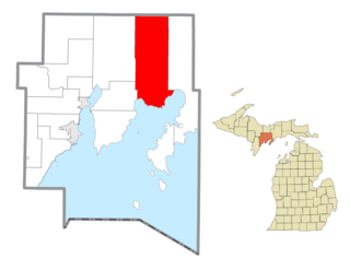
Raber Township is a civil township of Chippewa County in the U.S. state of Michigan. The population was 632 at the 2020 census.

<span class="mw-page-title-main">Nahma Township, Michigan</span> Civil township in Michigan, United States

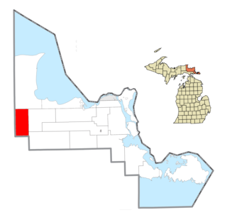
Nahma Township is a civil township of Delta County in the U.S. state of Michigan. The population was 468 at the 2020 census, slightly down from 495 at the 2010 census. Nahma was established in 1881 by the Bay De Noquet Lumber Company as the base for its upper Michigan lumbering operations.

<span class="mw-page-title-main">Osceola Township, Houghton County, Michigan</span> Civil township in Michigan, United States

Osceola Township is a civil township of Houghton County in the U.S. state of Michigan. The population was 1,822 at the 2020 census.

<span class="mw-page-title-main">Tawas City, Michigan</span> City in Michigan, United States

Tawas City is a city in and county seat of Iosco County in the U.S. state of Michigan. The population was 1,834 at the 2020 census. The city is mostly surrounded by Tawas Township, but the two areas are administered autonomously.

<span class="mw-page-title-main">Chippewa Township, Isabella County, Michigan</span> Civil township in Michigan, United States

Chippewa Township is a civil township of Isabella County in the U.S. state of Michigan. As of the 2020 census, the township population was 4,446. The city of Mount Pleasant is nearby to the west, and the Mount Pleasant post office, with ZIP code 48858, also serves the northern portion of Chippewa Township.

<span class="mw-page-title-main">Deerfield Township, Isabella County, Michigan</span> Civil township in Michigan, United States

Deerfield Township is a civil township of Isabella County in the U.S. state of Michigan. The population was 3,257 at the 2020 census.

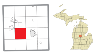
Chippewa Township is a civil township of Mecosta County in the U.S. state of Michigan. As of the 2020 census, the township population was 1,227.

<span class="mw-page-title-main">Greendale Township, Michigan</span> Civil township in Michigan, United States

Greendale Township is a civil township of Midland County in the U.S. state of Michigan. As of the 2020 census, the township population was 1,731.

Ferris Township is a civil township of Montcalm County in the U.S. state of Michigan. The population was 1,331 at the 2020 census.

Pierson Township is a civil township of Montcalm County in the U.S. state of Michigan. The population was 3,363 at the 2020 census. The village of Pierson is located within the township.

<span class="mw-page-title-main">Freeland, Michigan</span> Census-designated place & unincorporated community in Michigan, United States

Freeland is a census-designated place in Tittabawassee Township, Saginaw County in the U.S. state of Michigan. It is part of the Saginaw-Midland-Bay Metropolitan Area. As of the 2000 census, the CDP population was 5,147. The CDP covers an area in the central portion of Tittabawassee Township. The Freeland post office, ZIP code 48623, serves nearly the entire township, as well as portions of Midland and Williams townships to the north, Frankenlust and Kochville townships to the east, Thomas and Richland townships to the south, and Ingersoll Township to the west.

<span class="mw-page-title-main">East China Township, Michigan</span> Charter township in Michigan, United States

East China Township is a charter township of St. Clair County in the U.S. state of Michigan. The population was 3,704 at the 2020 Census.

<span class="mw-page-title-main">Decatur Township, Michigan</span> Township in Michigan, United States

Decatur Township is a civil township of Van Buren County in the U.S. state of Michigan. The population was 3,575 at the 2020 census. The village of Decatur is located within the township.

Richland Township is a civil township of Montcalm County in the U.S. state of Michigan. The population was 2,646 at the 2020 census, down from 2,778 in 2010.

References

  1. 1 2 "U.S. Census website". United States Census Bureau . Retrieved January 31, 2008.
  2. U.S. Geological Survey Geographic Names Information System: Bay Mills Township, Michigan
  3. "Explore Census Data". data.census.gov. Retrieved May 2, 2024.
  4. U.S. Geological Survey Geographic Names Information System: Bay Mills, Michigan
  5. "Geographic Identifiers: 2010 Demographic Profile Data (G001): Bay Mills township, Chippewa County, Michigan". U.S. Census Bureau, American Factfinder. Archived from the original on February 12, 2020. Retrieved September 19, 2014.
  6. "American FactFinder - Community Facts". American FactFinder. Archived from the original on November 21, 2014.
  7. "Chippewa ancestry by city - ePodunk". ePodunk. Archived from the original on August 25, 2006.
  8. Clarke, Wendy Ann (April 16, 2021). "Portrait of St. Kateri survives devastating church fire on Easter Sunday". The Catholic Register . Retrieved May 5, 2021.
  9. U.P. Church Named After American Saint Destroyed for Second Time (May 5, 2021) MLive.