
The Upper Peninsulaof Michigan—also known as Upper Michigan or colloquially the U.P.—is the northern and more elevated of the two major landmasses that make up the U.S. state of Michigan; it is separated from the Lower Peninsula by the Straits of Mackinac. It is bounded primarily by Lake Superior to the north, separated from the Canadian province of Ontario at the east end by the St. Marys River, and flanked by Lake Huron and Lake Michigan along much of its south. Although the peninsula extends as a geographic feature into the state of Wisconsin, the state boundary follows the Montreal and Menominee rivers and a line connecting them.

Mackinac County is a county in the Upper Peninsula of the U.S. state of Michigan. As of the 2020 census, the population was 10,834. The county seat is St. Ignace. Formerly known as Michilimackinac County, in 1818 it was one of the first counties of the Michigan Territory, as it had long been a center of French and British colonial fur trading, a Catholic church and Protestant mission, and associated settlement.

Luce County is a county located in the Upper Peninsula in the U.S. state of Michigan. As of the 2020 census, the population was 5,339, making it the second-least populous county in Michigan. The county seat is Newberry, Luce County's only incorporated community. The county was set off and organized in 1887 and named after former Michigan Governor Cyrus G. Luce.

Chippewa County is a county in the eastern Upper Peninsula of the U.S. state of Michigan. As of the 2020 Census, the population was 36,785. The county seat is Sault Ste. Marie. The county is named for the Ojibwe (Chippewa) people, and was set off and organized in 1826. Chippewa County comprises the Sault Ste. Marie, MI micropolitan statistical area.
Hulbert Township is a civil township of Chippewa County in the Upper Peninsula of the U.S. state of Michigan. As of the 2010 census, the township population was 168.

Pickford Township is a civil township of Chippewa County in the U.S. state of Michigan. As of the 2010 census, the township population was 1,595.

Raber Township is a civil township of Chippewa County in the U.S. state of Michigan. The population was 647 at the 2010 census.

Rudyard Township is a civil township of Chippewa County in the U.S. state of Michigan. As of the 2010 census, the township population was 1,370. In 2023, Rudyard Township was designated the "Snowy Owl Capital of Michigan".

Sault Ste. Marie is a city in the Upper Peninsula of the U.S. state of Michigan. It is the county seat of Chippewa County and is the only city within the county. With a population of 13,337 at the 2020 census, it is the second-most populated city in the Upper Peninsula, behind Marquette. It is the primary city of the Sault Ste. Marie, MI Micropolitan Statistical Area, which encompasses all of Chippewa County and had a population of 36,785 at the 2020 census. Sault Ste. Marie was settled by mostly French colonists in 1668, making it the oldest city in Michigan.
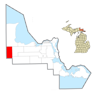
Clark Township is a civil township of Mackinac County in the U.S. state of Michigan. As of the 2020 census, the population was 1,917, down from 2,256 in 2010.
Newton Township is a civil township of Mackinac County in the U.S. state of Michigan. As of 2020, its population was 430.

St. Ignace is a city in the U.S. state of Michigan and the county seat of Mackinac County. The city had a population of 2,306 at the 2020 census. St. Ignace Township is located just to the north of the city, but the two are administered autonomously.

Mackinaw City is a village at the northernmost point of the Lower Peninsula of Michigan. Divided between Cheboygan and Emmet counties, Mackinaw City is the located at the southern end of the Mackinac Bridge, which carries Interstate 75 over the Straits of Mackinac to the Upper Peninsula. Mackinaw City, along with St. Ignace, serves as an access point to Mackinac Island. For these reasons, Mackinaw City is considered one of Michigan's most popular tourist attractions.
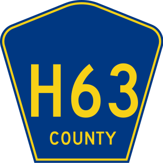
H-63 is a county-designated highway (CDH) in the Upper Peninsula of the US state of Michigan. The highway parallels the Interstate 75 (I-75) corridor between St. Ignace and Sault Ste. Marie. The road is called Mackinac Trail after the Upper Peninsula branch of an Indian trail used before European settlers reached the area. Originally, the roadway was built as a section of US Highway 2 (US 2) before being added to the CDH system in the 1970s.

The Sault Ste. Marie Tribe of Chippewa Indians, commonly shortened to Sault Tribe of Chippewa Indians or the more colloquial Soo Tribe, is a federally recognized Native American tribe in what is now known as Michigan's Upper Peninsula. The tribal headquarters is located within Sault Ste. Marie, the major city in the region, which is located on the St. Marys River.

M-129 is a state trunkline highway in the Upper Peninsula (UP) of the US state of Michigan. It runs from Cedarville to Sault Ste. Marie. South of Nine Mile Road in Chippewa County, M-129 overlays the Michigan Meridian. The section of M-129 that overlays the meridian is named Meridian Road. The highway between M-48 and the northern terminus is a part of the larger Lake Huron Circle Tour.
Kincheloe is an unincorporated community and census-designated place (CDP) in Chippewa County on the Upper Peninsula of the U.S. state of Michigan, named after the former Kincheloe Air Force Base, that was in turn named after noted pilot Iven Kincheloe.

Engadine is an unincorporated community in Mackinac County in the U.S. state of Michigan. The community is located within Garfield Township. As an unincorporated community, Engadine has no legally defined boundaries or population statistics of its own but does have its own post office with the 49827 ZIP Code.

Garnet is an unincorporated community in Mackinac County in the U.S. state of Michigan. The community is located within Hudson Township. As an unincorporated community, Garnet has no legally defined boundaries or population statistics of its own.

The Charlotte River is a tributary of the St. Marys River in the state of Michigan in the United States. The stream is 17.1 miles (27.5 km) long and drains an area of 58.4 square miles (151 km2) on the eastern Upper Peninsula. Via the St. Marys River, it is part of the watershed of Lake Huron. Via Lake Huron and the Great Lakes system, it is part of the larger watershed of the St. Lawrence River.


