
Labrador is a geographic and cultural region within the Canadian province of Newfoundland and Labrador. It is the primarily continental portion of the province and constitutes 71% of the province's area but is home to only 6% of its population. It is separated from the island of Newfoundland by the Strait of Belle Isle. It is the largest and northernmost geographical region in the four Atlantic provinces.

The Gulf of St. Lawrence fringes the shores of the provinces of Quebec, New Brunswick, Nova Scotia, Prince Edward Island, Newfoundland and Labrador, in Canada, plus the islands Saint-Pierre and Miquelon, possessions of France, in North America.
Sunnyside is a town on the Avalon Peninsula in Newfoundland and Labrador, Canada. It is in Division 1 on Bull Arm.

Basse-Côte-Nord Territory was a territory equivalent to a regional county municipality (TE) in eastern Quebec, Canada. The territory, whose geographical code was 982, was formed in 2002 when it separated from the Minganie Regional County Municipality and was superseded by Le Golfe-du-Saint-Laurent Regional County Municipality that was formed in July 2010.

Côte-Nord is an administrative region of Quebec, on the Quebec-Labrador Peninsula, Canada.

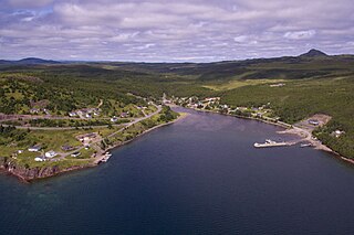
L'Anse Amour, romanticized version of Anse aux Morts, is a hamlet located on the north shore of the Strait of Belle Isle, Newfoundland and Labrador, Canada.

Belleoram is a village on the shores of Fortune Bay in the Canadian province of Newfoundland and Labrador.

Blanc-Sablon is a municipality located on the shore of Blanc-Sablon Bay, in the Strait of Belle-Isle, Le Golfe-du-Saint-Laurent RCM, Côte-Nord, Quebec, Canada.
Bay d'Espoir is an arm of Hermitage Bay in the Gulf of Saint Lawrence, located on the south coast of Newfoundland. Communities in Bay d'Espoir include: Milltown-Head of Bay d'Espoir, Morrisville, St. Alban's, St. Joseph's Cove, St. Veronica's and Miawpukek. The Miawpukek First Nation reserve of Samiajij Miawpukek is located in Bay d'Espoir.

Main River is a river in Newfoundland, Canada, a very popular canoeing destination. It is 57 km long, originates in the Long Range Mountains and enters the sea at White Bay.
Colinet is an incorporated town located on the northwest arm of St. Mary's Bay in Newfoundland and Labrador, Canada.

Pool's Cove is a fishing village located on the north west side of Fortune Bay, on the South Coast of Newfoundland, Canada. The town had a population of 143 in the 2021 Census.

Côte-Nord-du-Golfe-du-Saint-Laurent is a municipality in the regional county municipality of Le Golfe-du-Saint-Laurent in the Côte-Nord region of the province of Quebec, Canada. The municipality consists of two non-contiguous areas, both along the shores of the Gulf of Saint Lawrence. The larger main part stretches from the Natashquan River to the Gros Mécatina River and includes all populated places. The eastern part is a small section between Middle Bay and Brador.

Mount Sylvester is a large formation of rock of the glacier period found in central portion of the Island of Newfoundland. The mountain lies within the boundary of the Bay du Nord Wilderness Reserve of the province of Newfoundland and Labrador, Canada.

Bay du Nord Wilderness Reserve is located in central part of the Island of Newfoundland in the province of Newfoundland and Labrador, Canada. The area encompasses an area of 2,895 km2 (1,118 sq mi) and is considered one of the last remaining unspoiled areas of the province devoid of human habitat. It was officially created as a wilderness reserve in 1990.
Morrisville is a town in the Canadian province of Newfoundland and Labrador. The town had a population of 93 in the Canada 2021 Census. Morrisville is located in the Bay d'Espoir region and is 169 km from Grand Falls-Windsor.
South River is an incorporated municipality in the Canadian province of Newfoundland and Labrador, located at the south-southeast side of Bay de Grave, in Conception Bay. The town had a population of 674 according to the 2021 Canadian Census. South River is the site of the western terminus of Newfoundland and Labrador Route 60, also known as the Conception Bay Highway, which proceeds eastward to downtown St. John's. The river itself forms a natural boundary with neighbouring Clarke's Beach and is a scheduled salmon river. A second river, known as the Gould Brook, forms another natural boundary with the unincorporated local service district of Makinsons. South River is home to the Bay de Grave Regional Fire Department, a first step in developing successful regional cooperation amongst municipalities.

Blanc-Sablon Bay is a natural bay in municipality of Blanc-Sablon, in Le Golfe-du-Saint-Laurent Regional County Municipality, on the Côte-Nord (North-Shore) coast of Strait of Belle Isle, in Quebec, Canada.
Bay du Nord is an abandoned community in Hermitage Bay, Newfoundland and Labrador.

Division No. 1, Subdivision G is an unorganized subdivision on the Avalon Peninsula in Newfoundland and Labrador, Canada. It is in Division 1 and contains the unincorporated communities of Baccalieu Island, Besom Cove, Bradley's Cove, Burnt Point, Caplin Cove, Daniel's Cove, Grates Cove, Gull Island, Job's Cove, Kingston, Long Beach, Lower Island Cove, Low Point, Northern Bay, Ochre Pit Cove, Red Head Cove, Riverhead, Smooth Cove and Western Bay.

