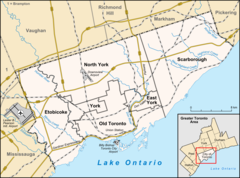
The Humber collects from about 750 creeks and tributaries in a fan-shaped area north of Toronto that encompasses portions of Dufferin County, the Regional Municipality of Peel, Simcoe County, and the Regional Municipality of York. The main branch runs for about 100 kilometres (60mi)[3] from the Niagara Escarpment in the northwest, while another major branch, known as the East Humber River, starts at Lake St. George in the Oak Ridges Moraine near Aurora to the northeast. They join north of Toronto and then flow in a generally southeasterly direction into Lake Ontario at what was once the far western portions of the city.[4] The river mouth is flanked by Sir Casimir Gzowski Park and Humber Bay Park East.
Name
There are two indigenous names attributed to the Humber. One is "Cobechenonk", for "leave the canoes and go back", attributed to the area's most recent native inhabitants, the Anishinaabe.[5] A second is “Niwa’ah Onega’gaih’ih,” “Little Thundering Waters.”[6] A French map from 1688 called the river "passage de taronto",[7] while Popple's map of 1733 shows the "Tanaovate River" beside the native settlement of Tejajagon.[8] Lieutenant-Governor John Graves Simcoe named it the Humber River, likely after the Humber estuary in England.[9]
History
The Humber has a long history of human settlement along its banks. Native settlement of the area is well documented archaeologically and occurred in three waves. The first settlers were the Palaeo-Indians who lived in the area from 10,000 to 7000 BC. The second wave, people of the Archaic period, settled the area between 7000 and 1000 BC and began to adopt seasonal migration patterns to take advantage of available plants, fish, and game. The third wave of native settlement was the Woodland period, which saw the introduction of the bow and arrow and the growing of crops which allowed for larger, more permanent villages. The Woodland period was also characterized by movement of native groups along what is known today as the Toronto Carrying-Place Trail, running from Lake Ontario up the Humber to Lake Simcoe and eventually to the northern Great Lakes.[3]
By the 17th century the area was a crucial point for travel, with the Humber River making up the southern portion of the Toronto Passage.
It is believed that Étienne Brûlé was the first European to encounter the Humber while travelling the Toronto Carrying-Place Trail. Brûlé passed through the watershed in 1615 on a mission from Samuel de Champlain to build alliances with native peoples, but left no written record. The Trail became a convenient shortcut to the upper Great Lakes for traders, explorers, and missionaries. A major landmark on the northern end of the trail in Lake Simcoe was used to describe the trail as a whole, and eventually the southern end became known simply as "Toronto" to the Europeans.[3]
During the 1660s this was the site of Teiaiagon, a permanent settlement of the Seneca used for trading with the Europeans. Popple's map of 1733 shows a prominent river beside "Tejajagon" which is assumed to be the Humber.
During late-17th and 18th century, the portage along this river was frequently used by the French traders as a short cut to the upper Great Lakes and the area north of Toronto.[10] In an attempt to secure the trade route from the British, the French established Magasin Royal, a trading post along the Humber River, near Baby Point. Completed in 1720, the trading post was abandoned shortly after the British fort in Oswego, New York was completed, as it diverted trade away from Magasin Royal.[11]
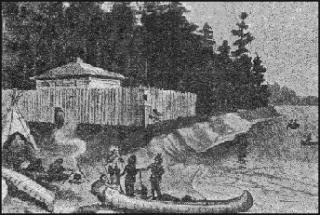
In 1750, the French built another fort near the mouth of the Humber River, with the intention of diverting aboriginals using it as a passage from proceeding to the British in Fort Oswego. Known as Fort Toronto, the fort saw immediate success, with demand outstripping the supply of goods the Fort was able to provide.[12] The success of the fort persuaded the Governor General of New France, the Marquis de la Jonquière to order the construction of a larger fort, with more trading capacity and military potential, in an effort to consolidate its hold of the region. Fort Rouillé, located in present-day Exhibition Place (east of the Humber River), was completed in the spring of 1751.[12] The fort continued to operate until 1759, during the Seven Years' War. Instructed to evacuate and raze the fort should Fort Niagara be captured, the garrison would vacate the area for Montreal after they were defeated at Fort Niagara in July 1759.[12]
The area was later secured by British forces in September 1760, when the British Army dispatched its chief scout and intelligence officer, Robert Rogers, along with 200 men and fifteen whale boats to take control of the former French fort.[13] In 1772, Jean-Bonaventure Rousseau received a license to trade with the First Nations living within the vicinity of the mouth of the Humber River.[14] His license was later inherited by his son, Jean Baptiste Rousseau, after his death in 1774. Rousseau maintained several contacts in the area, although did not permanently relocate there until 1792; when he established a trading post near the mouth of the Humber River.[14]
Rousseau piloted John Graves Simcoe's ship into Toronto Bay to officially commence the settlement of York in 1793. Most of the British attention was focused to the east of the Humber, around the protected Toronto Bay closer to the Don River. Settlement was scattered until after the War of 1812 when many loyalists moved to the area, who were joined by immigrants from Ireland and Scotland who chose to remain in British lands.[3]
The Humber River saw water levels rise significantly after Hurricane Hazel. The resulting flood devastated nearby residences on Raymore Drive.
Upon his arrival in York, Simcoe was keenly aware of the need for a lumber mill and grist mill in the area. He had constructed a sawmill on the west bank of the river near present-day Bloor Street in 1793, which was operated by John Wilson. In 1797 Simcoe managed to get a grist mill established on the Humber River. It was owned and operated by John Lawrence. Over the years, numerous mills have been operated along the river by such men as William Cooper, W. P. Howland, Thomas Fisher, John Scarlett, William Gamble and Joseph Rowntree. The last grist mill on the Humber, Hayhoe Mills in Woodbridge, closed in 2007.
By 1860 the Humber Valley was extensively deforested. This decreased the stability of the river banks and increased damages done by periodic flooding. In 1878 a disastrous flood destroyed the remaining water-powered mills. As the Toronto area grew, the lands around the Humber became important farming areas; in addition, some areas of the river's flood plain were developed as residential. This led to serious runoff problems in the 1940s, which the Humber Valley Conservation Authority was established to address. But in 1954, Hurricane Hazel raised the river to devastating flood levels, destroying buildings and bridges; on Raymore Drive, 60 homes were destroyed and 35 people were killed.
The Metropolitan Toronto and Region Conservation Authority (MTRCA later TRCA) succeeded the Humber Valley authority in 1957 (the word "Metropolitan" was dropped in 1998).[3] More recently, a task force within the Authority was formed to further clear the Humber as a part of the Great Lakes 2000 Cleanup Fund.[citation needed]
The Humber watershed is a hydrological feature of south-central Ontario, Canada, principally in north and west Toronto. It has an area of 903 square kilometres (349sqmi), flowing through numerous physio-graphic regions, including the Oak Ridges Moraine and the Niagara Escarpment.[15] The watershed is bounded on the west by the Credit River, Etobicoke Creek and Mimico Creek watersheds, and on the east by the Garrison Creek, Don River and Rouge River watersheds, all six of which empty into Lake Ontario; on the north by the Nottawasaga River which empties into Lake Huron; and on the northeast by the Holland River, which empties into Lake Simcoe.[3]
Unlike the Don to the east, the Humber remained relatively free from industrialization as Toronto grew. Since the flooding of Hurricane Hazel, it has been largely developed or redeveloped as parkland, with the extensive and important wetlands on its southern end remaining unmolested. Whereas the mouth of the Don is often clogged with flotsam and is obstructed by low bridges, the Humber is navigable and used for recreation and fishing.
Today the majority of the Toronto portion of the Humber is parkland, with paved trails running from the lake shore all the way to the northern border of the city some 30km away. Trails following the various branches of the river form some 50km of bicycling trails, much of which are in decent condition. Similar trails on the Don tend to be narrower and in somewhat worse condition, but the complete set of trails is connected along the lake shore, for some 100km of off-road paved trails.
Tributaries
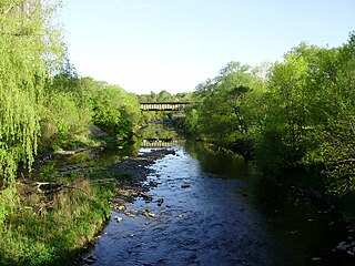
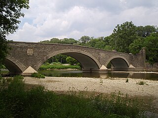
Railway bridge over the Humber River
Albion Creek - The Albion Creek is a tributary of the West Humber. It flows south-west from east of Bolton, meeting the West Humber from the north, between Islington Avenue and Martin Grove Road. It is approximately 9km long.
Berry Creek - Berry Creek originates at Martin Grove Road just north of Rexdale Boulevard. It flows south-east to meet the main Humber from the west, west of the intersection of Albion Road and Weston Road, where Albion Road crosses the Humber. It is about 3.8km long.
Black Creek - The Black Creek originates north of Toronto in Vaughan and meanders southerly to meet the lower Humber from the east about 800 m north of Dundas Street, in Lambton Golf and Country Club, James Gardens occupies the opposite bank of the river.
Centreville Creek
East Humber - The East Humber flows from north of Toronto, meeting the main branch of the Humber in Woodbridge, just north of Highway 7. Its watershed extends east to Yonge Street and north to King City. Its source is Wilcox Lake and its wetlands east of Yonge Street and the village of Oak Ridges.
Emery Creek - Emery Creek flows from its source west of Finch Avenue and Weston Road, south to meet the main Humber 500 metres west of Weston Road, about 1km south of Finch Avenue. It is about 2.4km long.
Humber Creek - The Humber Creek runs south east, from its source near Islington Avenue and Dixon Road through residential areas, meeting the lower Humber from the west about 750 metres north of Eglinton Avenue. It is about 3.8km long.
King Creek - King Creek is a tributary of the East Humber. It flows southerly from near Highway 27 and 16th Side Road to meet the East Humber south of King Road, east of Nobleton. The settlement of King Creek is located to the east of the confluence.
Purpleville Creek
Rainbow Creek
Salt Creek
Silver Creek - The Silver Creek runs south-westerly from its source about 300 metres west of Eglinton Avenue and Royal York Road, partly within a golf course, through residential areas to meet the lower Humber from the west about 1.2km south of Eglinton Avenue. It is about 2km long.
West Humber - The West Humber meets the main branch of the Humber east of Albion Road and about 800 metres west of Sheppard Avenue and Weston Road. The West Humber itself has several branches flowing from north-west of Toronto.
Source: Toronto and Region Conservation Authority,[16] The Atlas of Canada.[17]
Yonge Street is a major arterial route in the Canadian province of Ontario connecting the shores of Lake Ontario in Toronto to Lake Simcoe, a gateway to the Upper Great Lakes. Ontario's first colonial administrator, John Graves Simcoe, named the street for his friend Sir George Yonge, an expert on ancient Roman roads.
The Don River is a watercourse in southern Ontario that empties into Lake Ontario, at Toronto Harbour. Its mouth was just east of the street grid of the town of York, Upper Canada, the municipality that evolved into Toronto, Ontario. The Don is one of the major watercourses draining Toronto that have headwaters in the Oak Ridges Moraine.
The Toronto Carrying-Place Trail, also known as the Humber Portage and the Toronto Passage, was a major portage route in Ontario, Canada, linking Lake Ontario with Lake Simcoe and the northern Great Lakes. The name comes from the Mohawk term toron-ten, meaning "the place where the trees grow over the water", an important landmark on Lake Simcoe through which the trail passed.
The Rouge River is a river in Markham, Pickering, Richmond Hill and Toronto in the Greater Toronto Area of Ontario, Canada. The river flows from the Oak Ridges Moraine to Lake Ontario at the eastern border of Toronto, and is the location of Rouge Park, the only national park in Canada within a municipality. At its southern end, the Rouge River is the boundary between Toronto and southwestern Pickering in the Regional Municipality of Durham.
Etobicoke Creek is a river in the Greater Toronto Area of Ontario, Canada. It is a tributary of Lake Ontario and runs from Caledon to southern Etobicoke, part of the City of Toronto. The creek is within the jurisdiction of the Toronto and Region Conservation Authority.
Fort Rouillé was a French trading post located in what is now Toronto, Ontario, Canada. Fort Rouillé was constructed by the French in 1751, building upon the success of a trading post they established in the area a year earlier, known as Fort Toronto. Fort Rouillé was named for Antoine Louis Rouillé, who at the time of its establishment was Secretary of State for the Navy in the administration of King Louis XV of France. It served as a trading post with the local indigenous peoples from the region.
The Toronto and Region Conservation Authority (TRCA) is a conservation authority in southern Ontario, Canada. It owns about 16,000 hectares of land in the Toronto region, and it employs more than 400 full-time employees and coordinates more than 3,000 volunteers each year. TRCA's area of jurisdiction is watershed-based and includes 3,467 square kilometres (1,339 sq mi) – 2,506 on land and 961 water-based in Lake Ontario. This area comprises nine watersheds from west to east – Etobicoke Creek, Mimico Creek, Humber River, Don River, Highland Creek, Petticoat Creek, Rouge River, Duffins Creek and Carruthers Creek.
Toronto was founded as the Town of York and capital of Upper Canada in 1793 after the Mississaugas surrendered the land to the British in the Toronto Purchase. For over 12,000 years, Indigenous People have lived in the Toronto area. The ancestors of the Huron-Wendat were the first known groups to establish agricultural villages in the area about 1,600 years ago.
Black Creek is a river in the Golden Horseshoe region of Ontario, Canada. It flows from the city of Vaughan in the Regional Municipality of York to the Humber River in Toronto. Black Creek is smaller than most of the waterways in the Greater Toronto Area.
Étienne Brûlé Park is located in the Humber River valley just north of Bloor Street West in Toronto, Ontario, Canada. It is named after Étienne Brûlé, an early French explorer in the Toronto area. It is believed that Étienne Brûlé was the first European to see Lake Ontario in 1615, from a high point of land beside the Humber.
Humber Bay is a bay of Lake Ontario south of Toronto, Ontario, Canada. It is located between Ontario Place on the east and Mimico Creek to the west. The bay gives its name to Etobicoke's Humber Bay neighbourhood.
The Queensway–Humber Bay, known officially as Stonegate–Queensway, is a neighbourhood in the southwest of Toronto, Ontario, Canada. It is located in the southeast area of the former City of Etobicoke.
Vandorf is a hamlet located in the town of Whitchurch–Stouffville, Ontario, in Canada. It is the most westerly settlement within the Town of Whitchurch-Stouffville. With a population of approximately 722, Vandorf consists mainly of estate residential homes and farms.
Highland Creek is a river in the Scarborough district of Toronto, Ontario, emptying into Lake Ontario at the eastern end of the Scarborough Bluffs. It is home to several species of fish including trout, carp, bass and salmon. It is a meandering river which, like most rivers in Toronto, travels through a glacial ravine formed after the last Ice Age. The Highland Creek watershed, including tributaries, is almost entirely contained within Scarborough.
Twelve Mile Creek is a waterway located on the Niagara Peninsula in the Regional Municipality of Niagara in Southern Ontario, Canada. Its headwaters are located in the town of Pelham, encompassing some of the most unspoiled and natural areas of Niagara area. The creek's lower reaches flow through urban areas of Thorold and St. Catharines and has been heavily altered by human activity for almost two centuries. The creek was first known as "Ashquasing" by the Mississaugas Indigenous people, the name meaning "that which lies at the end" in the Anishinaabe language.
The Black River is a river in the Regional Municipality of York and the Regional Municipality of Durham in Central Ontario, Canada. It is part of the Great Lakes Basin, and is a tributary of Lake Simcoe; the entire watershed is under the auspices of the Lake Simcoe Region Conservation Authority.
The Toronto waterway system comprises a series of natural and man-made watercourses in the Canadian city of Toronto. The city is dominated by a large river system spanning most of the city including the Don River, Etobicoke Creek, Highland Creek, Humber River, Mimico Creek and Rouge River.
Duffins Creek is a waterway in the eastern end of the Greater Toronto Area in Ontario, Canada. The watershed of the Duffins Creek is part of the Durham Region and the York Region.
Dundas Street is a major historic arterial road in Ontario, Canada. The road connects the city of Toronto with its western suburbs and several cities in southwestern Ontario. Three provincial highways—2, 5, and 99—followed long sections of its course, although these highway segments have since been downloaded to the municipalities they passed through. Originally intended as a military route to connect the shipping port of York to the envisioned future capital of London, Ontario, the street today connects Toronto landmarks such as Yonge–Dundas Square and the city's principal Chinatown to rural villages and the regional centres of Hamilton and London.
This page is based on this Wikipedia article Text is available under the CC BY-SA 4.0 license; additional terms may apply. Images, videos and audio are available under their respective licenses.