List of neighbourhoods in Toronto

Last updated

Roncesvalles, a 'core' neighbourhood of Toronto, in 2001 Roncesvalles Toronto Roncesvalles Avenue.jpg
Roncesvalles, a 'core' neighbourhood of Toronto, in 2001

The strength and vitality of the many neighbourhoods that make up Toronto, Ontario, Canada has earned the city its unofficial nickname of "the city of neighbourhoods." [1] There are 158 neighbourhoods officially recognized by the City of Toronto (in 2022, 34 neighbourhoods were created from 16 of the previous 140) [2] and upwards of 240 official and unofficial neighbourhoods within city limits. [3]

Contents

The current City of Toronto is the amalgamation of the former Metropolitan Toronto municipalities. Along with the original City of Toronto, these are East York, Etobicoke, North York, Scarborough, and York. The names of these municipalities are still often used by Toronto residents, sometimes for disambiguation purposes as amalgamation resulted in duplicated street names. The area known as Toronto before the 1998 amalgamation is sometimes called the "Old Toronto", and "the core". For administrative purposes, Toronto is divided into four districts: Etobicoke-York, North York, Scarborough and Toronto-East York.

Map of Toronto including the former municipalities that existed before 1998 Toronto map.png
Map of Toronto including the former municipalities that existed before 1998

The Old Toronto district is, by far, the most populous and densest part of the city. It is also the business and administrative centre of the city. The uniquely Torontonian bay-and-gable housing style is common throughout the former city. The "inner ring" suburbs of York and East York are older, predominantly middle-income areas, and ethnically diverse. Much of the housing stock in these areas consists of pre-World War II single-family houses and some post-war high-rises. Many of the neighbourhoods in these areas were built up as streetcar suburbs and contain many dense and mixed-use streets, some of which are one-way. They share many characteristics with sections of the "old" city outside the downtown core. The "outer ring" suburbs of Etobicoke, Scarborough, and North York are much more suburban in nature, although even these districts have some old-city characteristics (in particular southern Etobicoke along the shore of Lake Ontario) in areas bordering Old Toronto, and have developed modern urban centres of their own, such as North York City Centre around Mel Lastman Square.

The following is a list of the more notable neighbourhoods, organized by former municipality.

Neighbourhoods by former municipality

Toronto

Old Toronto refers to the City of Toronto and its limits from 1967 to 1997. It is sometimes referred to as the "South" or "Central" district, and includes the "downtown core". Some of these names such as "The Fashion District" are (or were) used as marketing for the areas or by BIAs; this area is actually called "King-Spadina" by locals. Another example is the "Old Town of York", also known as "King and Parliament" (although that intersection is one block east of the original ten blocks that formed the old town). Some people in the area[ who? ] also consider it to be a suburb of the main city of Toronto, as many choose to move there in pursuit of a more relaxed and "backwoods" vibe. [4]

Many were recreated or named to reconnect the areas with their past history, early beginnings, or even recent use and prominence. Some historical city "wards" used in the 19th century are no longer used: St. David's, St. John's, St. Paul's, St. George's, St. Andrew's, and St. Patrick's wards. There was a ward named for the patron saint of each of the three British nationalities: English (St. George), Scottish (St. Andrew), Welsh (St. David) and Irish (St. Patrick). St. George, St. Andrew and St. Patrick still survive as subway stations, though St. George station is not named after the ward, but after St. George Street instead, itself named after Quetton St. George, a local military officer and landowner. St. Lawrence's Ward (named after the patron saint of Canada and the river, itself also named after the saint) remains, known today as "St. Lawrence". St. Paul's (named after the saint) remains as the name of an electoral district for each of the three levels of government, although the electoral district has very little to no overlap with the historic St. Paul's Ward and beginning in the 2015 Canadian federal election, the electoral district was renamed Toronto—St. Paul's. This meant that the St. Paul's electoral district is a misnomer for much of the history of the electoral district.

For the purposes of geographic distinction, Old Toronto is broken down into four subsections:

Downtown Core (Central)

East End

North End

West End

East York

An autonomous urban borough until 1997, East York is located north of Danforth Avenue between the Don River to the west and Victoria Park Avenue to the east, though Shoppers World Danforth was located in East York. East York was an exclave of York from 1922 to 1924 and became a separate municipality to simplify governance. East York developed contemporaneously with the West End of old Toronto, and it is similar in form and character. In 1967, East York was expanded to include the Town of Leaside. Since the 1998 amalgamation, it is administered together with old Toronto, and separate from Scarborough, North York, and Etobicoke-York, by the "Toronto and East York Neighbourhood Council".

East York itself is commonly divided into two zones with mainly Edwardian urban neighbourhoods situated south of Taylor-Massey Creek and referred to as Old East York.

Etobicoke

The former township and city of Etobicoke is on the west side of the Humber River. Several of its neighbourhoods, such as Long Branch, New Toronto, and Mimico, were villages independent of Etobicoke. Others, such as Claireville, Islington and Thistletown were former postal villages established when Etobicoke was an agrarian district. Others are residential subdivisions built after World War II as Toronto expanded.

Etobicoke is often divided into three zones: north, central, and south, roughly approximate to that of the electoral districts of all three levels of government.

North York

The former city of North York is located north of York, Old Toronto, and East York, from the Humber River to the west and Victoria Park Avenue to the east. North York is split by Yonge Street into an east section and a west section. Several of North York's neighbourhoods (such as Lansing, Newtonbrook and Willowdale) developed from postal villages when North York Township was primarily agrarian. Others are residential subdivisions developed after World War II. North York City Centre is a commercial district developed to be the 'downtown' of the city.

Scarborough

The district of Scarborough extends from the east side of Victoria Park Avenue to the eastern border of Toronto. West Rouge was transferred from Pickering to Scarborough in 1974 as part of the establishment of Durham Region. It is the largest district by area.

Many of the neighbourhoods, such as Agincourt, Brown's Corners and Milliken, correspond to former postal villages supporting the then-agrarian township. Others are residential subdivisions developed after World War II. Others are commercial districts.

York

The former city of York is situated between Old Toronto and North York, west of Bathurst Street (aside from the neighbourhood of Tichester at the southeasternmost corner of the former city, which extends as far east as Walmer Road and includes much of St. Clair West station, including its northern entrance on Heath Street, as well as St. Michael's College School). The community of Weston, to the northwest, was itself an independent village. Several neighbourhoods are former residential subdivisions built on the limits with Toronto before and after World War II.

York is often divided into two sections: a western section and an eastern section, on either side of GO Transit's Barrie rail line.

History

Lists of city-designated neighbourhoods

For administrative purposes, the City of Toronto divides the city into 158 neighbourhoods. These divisions are used for internal planning purposes. The boundaries and names often do not conform to the usage of the general population or designated business improvement areas. A number of neighbourhood maps of Toronto do exist, some produced by real estate firms and some by Internet portals. A project to map the neighbourhoods according to the common usage of the residents was done by the Toronto Star newspaper. Based on feedback from Toronto Star readers, it has produced the most comprehensive, albeit informal, neighbourhood map. 31 of these neighbourhoods are Neighbourhood Improvement Areas with the strategy to strengthen the social, economic and physical conditions and delivers local impact for city-wide change in these areas. [2]

Table

CDN numberCity-designated neighbourhoodFormer city/boroughNeighbourhoods coveredNeighbourhood Improvement AreaMap
129Agincourt NorthScarborough Agincourt and BrimwoodN
128Agincourt South-Malvern WestScarborough Agincourt and Malvern N Malvern to locator.gif
20AlderwoodEtobicoke Alderwood N Alderwood to locator.png
95AnnexOld City of Toronto The Annex and Seaton Village N Annex-to-locator.png
42Banbury-Don MillsNorth York Don Mills N
34Bathurst ManorNorth York Bathurst Manor N
169Bay–CloverhillOld City of TorontoN
52Bayview VillageNorth York Bayview Village N
49Bayview Woods-SteelesNorth York Bayview Woods N
39Bedford Park-NortownNorth York Bedford Park, Ledbury Park, and Nortown N Bedfordparknortown to locator.gif
112Beechborough-GreenbrookYork Keelesdale and Silverthorn Y Beechboroughgreenbrook to locator.gif
156 Bendale–Glen Andrew ScarboroughBendaleN
157 Bendale South ScarboroughBendaleN
122Birchcliffe-CliffsideScarborough Birch Cliff and Cliffside N
24Black CreekNorth York Jane and Finch Y
69Blake-JonesOld City of Toronto The Pocket and Riverdale N Blakejones to locator.png
108Briar Hill-BelgraviaYork Fairbank N Briarhillbelgravia to locator.png
41Bridle Path-Sunnybrook-York MillsNorth York The Bridle Path and York Mills N
57Broadview NorthEast York Old East York N
30Brookhaven-AmesburyNorth York Amesbury N
71Cabbagetown-South St. James TownOld City of Toronto Cabbagetown and St. James Town N
109Caledonia-FairbankYork Fairbank and Cedarvale N
96Casa LomaOld City of Toronto Casa Loma and Wychwood N Casaloma to locator.png
133Centennial ScarboroughScarborough Port Union and Centennial N
167Church–WellesleyOld City of Toronto Church and Wellesley and Toronto Metropolitan University N
120Clairlea-BirchmountScarborough Clairlea N
33Clanton ParkNorth York Wilson Heights N Clantonpark to locator.png
123CliffcrestScarborough Cliffside N
92 Corso Italia-Davenport Old City of Toronto Corso Italia, Davenport, Earlscourt, and Regal Heights N Corsoitaliadavenport to locator.png
59Danforth - East YorkEast York Old East York, The Danforth N
66DanforthOld City of Toronto The Danforth N
47Don Valley VillageNorth York Don Valley Village, The Peanut N
126 Dorset Park ScarboroughDorset ParkN
168Downtown Yonge EastOld City of TorontoN
171Junction–Wallace EmersonOld City of Toronto Dovercourt Park, Wallace Emerson, Junction Triangle and Davenport N
172Dovercourt VillageOld City of Toronto Dovercourt Park N
155 Downsview North York Downsview Y Downsviewrodingcfb to locator.png
83Dufferin GroveOld City of Toronto Brockton and Dufferin Grove N Dufferingrove to locator.png
62East End-DanforthOld City of Toronto Upper Beaches, East Danforth N
148Easr L'AmoreauxScarborough L'Amoreaux, Leacock, and Bridlewood N
9Edenbridge-Humber ValleyEtobicoke Humber Valley N
138Eglinton EastScarborough Eglinton East Y Eglintoneast to locator.png
5 Elms-Old Rexdale Etobicoke The Elms and Rexdale Y
32Englemount-LawrenceNorth York Lawrence Manor and Glen Park N Englemountlawrence to locator.png
11Eringate-Centennial-West DeaneEtobicoke Centennial Park and West Deane Park N
163Fort York–Liberty VillageOld City of Toronto Liberty Village, Exhibition Place N
159 Etobicoke City Centre Etobicoke Islington-Six Points N
13Etobicoke West MallEtobicoke Centennial Park and Eatonville N Etobicoke-west-mall to locator.gif
44Flemingdon ParkNorth York Flemingdon Park Y
102Forest Hill NorthOld City of Toronto Forest Hill N Foresthill to locator.gif
101Forest Hill SouthOld City of Toronto Forest Hill N Foresthill to locator.gif
25Glenfield-Jane HeightsNorth York Jane and Finch Y
141 Golfdale–Cedarbrae–Woburn ScarboroughY
65Greenwood-CoxwellOld City of Toronto Leslieville N
140GuildwoodScarborough Guildwood N Guildwood to locator.gif
53Henry FarmNorth York Henry Farm N
88 High Park North Old City of TorontoHigh Park North, West BendN High-pk-north-to-locator.png
87High Park-SwanseaOld City of TorontoHigh Park, Roncesvalles and Swansea N
134Highland CreekScarborough Highland Creek N
48 Hillcrest Village North YorkHillcrest VillageN
161 Humber Bay Shores Etobicoke Mimico, Humber BayN
8 Humber Heights-Westmount EtobicokeHumber Heights-WestmountN
21 Humber Summit North YorkHumber SummitY
22HumbermedeNorth York Humbermede and Emery Y
106Humewood-CedarvaleYork Cedarvale and Humewood N Humewoodcedarvale to locator.gif
125IonviewScarborough Ionview Y Ionview to locator.gif
158 Islington Etobicoke Islington-Six Points N
90Junction AreaOld City of Toronto The Junction N Junction to locator.gif
110Keelesdale-Eglinton WestYork Keelesdale and Silverthorn Y Keelesdale-eglinton west.gif
124Kennedy ParkScarborough Scarborough Junction Y
78Kensington-ChinatownOld City of Toronto Alexandra Park, Chinatown, Grange Park, Kensington Market N
6Kingsview Village-The WestwayEtobicoke Kingsview Village and Richview Y Kingsviewwestway to locator.gif
15Kingsway SouthEtobicoke The Kingsway N
147L'Amoreaux WestScarborough L'Amoreaux, Leacock, and Bridlewood N
114Lambton Baby PointYork Baby Point and Old Mill N Lambtonbabypoint to locator.gif
38Lansing-WestgateNorth York Lansing N
105Lawrence Park NorthOld City of Toronto Bedford Park, Teddington Park, and Wanless Park N
103Lawrence Park SouthOld City of Toronto Lawrence Park, Lytton Park, North Toronto N
56Leaside-BenningtonEast York Leaside N
84Little PortugalOld City of Toronto Little Portugal and Brockton N
19Long BranchEtobicoke Long Branch N Longbranch to locator.gif
146 Malvern East ScarboroughMalvernN
145 Malvern West ScarboroughMalvernN
29 Maple Leaf North YorkN
12 Markland Wood EtobicokeMarkland WoodN
130 Milliken ScarboroughMillikenN
160 Mimico–Queensway Etobicoke Mimico N
135 Morningside Scarborough Morningside N
144 Morningside Heights ScarboroughMalvernY
73 Moss Park Old City of TorontoMoss Park, Corktown and Garden District N Mosspark to locator.gif
115Mount DennisYork Mount Dennis Y Mountdennis to locator.gif
2Mount Olive-Silverstone-JamestownEtobicoke Smithfield Y Mountolivesilverstonejamestown to locator.gif
99Mount Pleasant EastOld City of Toronto Davisville Village, North Toronto N
18 New Toronto EtobicokeNew TorontoN Newtoronto to locator.gif
50Newtonbrook EastNorth York Newtonbrook N
36Newtonbrook WestNorth York Newtonbrook N
68North RiverdaleOld City of Toronto Riverdale N
74North St. James TownOld City of Toronto St. James Town N
173North TorontoOld City of Toronto North Toronto N
54 O'Connor–Parkview East YorkParkview Hills, Topham ParkN
154Oakdale–Beverly HeightsNorth York Downsview Y
121 Oakridge ScarboroughOakridgeY
107 Oakwood Village YorkOakwood VillageN Oakwoodvaughan to locator.gif
58 Old East York East YorkOld East YorkN
80 Palmerston-Little Italy Old City of Toronto Little Italy and PalmerstonN
149 Parkwoods–O'Connor Hills North York Parkwoods N
150 Fenside–Parkwoods North YorkN
23 Pelmo Park-Humberlea North YorkHumberleaN Pelmoparkhumberlea to locator.gif
67Playter Estates-DanforthOld City of Toronto Playter Estates and Greektown N
46Pleasant ViewNorth York Pleasant View N
10Princess-RosethornEtobicokePrincess Anne Manor, Thorncrest Village, and Princess MargaretN
72 Regent Park Old City of TorontoRegent Park, Trefann Court Y Regentpark to locator.gif
4Rexdale-KiplingEtobicoke Rexdale N
111 Rockcliffe-Smythe YorkHarwood, SymeY
86RoncesvallesOld City of Toronto Roncesvalles N Roncesvalles-to-locator.gif
98Rosedale-Moore ParkOld City of Toronto Rosedale and Moore Park N
131RougeScarborough West Rouge, Rouge Park N
89 Runnymede-Bloor West Village Old City of TorontoRunnymede-Bloor West VillageN
28 Rustic North YorkY
139 Scarborough Village ScarboroughY
174South Eglinton–DavisvilleOld City of Toronto Davisville Village N
70 South Riverdale Old City of TorontoN
85South ParkdaleOld City of Toronto Parkdale, South Parkdale Y
40 St. Andrew-Windfields North York York Mills and Hoggs Hollow N
116 Steeles ScarboroughN
16 Stonegate-Queensway EtobicokeHumber Bay, QueenswayN
118 Tam O'Shanter-Sullivan ScarboroughN
61Taylor MasseyEast York Crescent Town Y
63 The Beaches Old City of TorontoThe Beach/Beaches, Beaches NorthN
3 Thistletown-Beaumond Heights EtobicokeY
55 Thorncliffe Park East YorkY
81 Trinity-Bellwoods Old City of TorontoN
79 University Old City of TorontoN
43 Victoria Village North YorkY
164 Wellington Place Old City of TorontoN
165 Harbourfront–CityPlace Old City of TorontoN
166 St Lawrence-East Bayfront The Islands Old City of Toronto Distillery District, Old Town, St. Lawrence N
136 West Hill ScarboroughY
1 West Humber-Clairville EtobicokeN
162West Queen WestOld City of Toronto Niagara N
143 West Rouge ScarboroughMalvernN
35 Westminster-Branson North YorkN
113 Weston YorkY
91 Weston-Pelham Park Old City of TorontoCarlton, Davenport, St. Clair GardensY
119 Wexford-Maryvale ScarboroughN
152 East Willowdale North YorkN
153AvondaleNorth YorkN
37 Willowdale West North YorkN
7 Willowridge-Martingrove-Richview EtobicokeN
142 Woburn North ScarboroughY
64 Woodbine Corridor Old City of TorontoN
60 Woodbine-Lumsden East YorkN
94 Wychwood Old City of TorontoN
170Yonge–Bay CorridorOld City of Toronto Bay Street, Financial District N
100 Yonge–Eglinton Old City of Toronto Chaplin Estates N
151Yonge–DorisNorth YorkN
97 Yonge–St. Clair Old City of TorontoN
27 York University Heights North YorkY
31Yorkdale-Glen ParkNorth York Glen Park, Lawrence Heights N

Business improvement areas

There are also several dozen city designated business improvement areas, covering almost all of Toronto's commercial areas. Some of these serve a particular ethnic group or several similar ethnic groups as part of an ethnic enclave.

Multiple listing service districts and neighbourhoods

After the update of Toronto Multiple listing service (MLS) on July 5, 2011, the Toronto Real Estate Board (TREB) introduced a new search feature for the Toronto MLS, used by real estate agents operating in the region. MLS searches can be refined at three levels and MLS users can search houses by area, then by municipality, and then by neighbourhood or community. As with the other MLS services for other jurisdictions, it used Microsoft's Bing Maps for its web mapping features until 2018, when it switched to Google Maps. These feature changes were the first change of this magnitude in about 50 years of Toronto MLS history since its establishment. [5]

The change was designed to eliminate the obsolete coding systems whereby Greater Toronto was divided into 86 artificial districts denominated by alphanumeric codes. Due to the growing population in the city and the increasing difficulty of browsing the code-based system, the TREB made a radical change, which is intended to simplify the use of MLS for real estate agents and home buyers. [6]

Because Toronto is a populous municipality of its own, the core city area will continue to be split into coded districts, although each of the districts will in turn contain neighbourhoods. Hence, the city will be easily searchable as well. [6]

The following table contains a complete list of Toronto districts with a possibly incomplete list of Toronto neighbourhoods within each district: [7] [8]

District NumberNeighbourhoods Included
C01 Downtown, Harbourfront, Little Italy, Little Portugal, Dufferin Grove, Palmerston, University, Yonge–Bay Corridor, Kensington Market, Chinatown, Trinity Bellwoods, South Niagara, Island airport, The Islands, Waterfront communities C1, Queen's Park, Ontario Provincial Government, Victoria Hotel, Central Bay Street, First Canadian Place, Design Exchange, Adelaide, Union Station
C02 The Annex, Yorkville, South Hill, Summerhill, Wychwood Park, Deer Park, Casa Loma
C03 Forest Hill South, Oakwood–Vaughan, Humewood–Cedarvale, Corso Italia, Forest Hill Road Park
C04 Bedford Park, Lawrence Manor, North Toronto, Forest Hill North, Lawrence Park, Lawrence Heights, Roselawn
C06 North York, Clanton Park, Bathurst Manor
C07 Willowdale West, Newtonbrook West, Westminster–Branson, Lansing-Westgate
C08 Cabbagetown, St. Lawrence Market, Toronto waterfront, Moss Park, Church and Wellesley, Garden District, Regent Park, St. James Town, Ryerson, Berczy Park
C09 Moore Park, Rosedale
C10 Davisville Village, Midtown Toronto, Mount Pleasant, Davisville North, Davisville
C11 Leaside, Thorncliffe Park, Flemingdon Park
C12 York Mills, St.Andrew - Windfields, Bridle Path, Sunnybrook, York Mills West
C13 Don Mills, Parkwoods, Victoria Village, Banbury, Parkwoods
C14 Newtonbrook East, Willowdale East, Newtonbrook
C15 Hillcrest Village, Bayview Woods-Steeles, Bayview Village, Don Valley Village, Henry Farm, Pleasant View
E01 Riverdale, Danforth (Greektown), Leslieville, Blake-Jones, Greenwood, Coxwell, Studio District
E02 The Beaches, Woodbine Corridor, East End - Danforth, The Beaches West, South Central Letter Processing Plant Toronto
E03 Danforth (Greektown), East York, Playter Estates, Broadview North (Old East York), O'Connor–Parkview, Crescent Town, Woodbine Heights, Woodbine Gardens, Parkview Hill
E04 The Golden Mile, Dorset Park, Wexford, Maryvale, Scarborough Junction (Kennedy Park), Ionview, Clairlea, Birchmount
E05 Steeles, L'Amoreaux West, Tam O'Shanter – Sullivan, Clarks Corners, L'Amoreaux
E06 Birch Cliff, Oakridge, Hunt Club, Cliffside
E07 Agincourt, Malvern West, Milliken
E08 Scarborough Village, Cliffcrest, Guildwood, Eglinton East (Knob Hill)
E09 Scarborough City Centre, Woburn, Morningside, Bendale (Cedarbrae), Cedarbrae
E10 Rouge (South), Port Union (Centennial Scarborough), West Hill, Highland Creek, Port Union
E11 Rouge (West), Malvern, Rouge, Upper Rouge
W01 High Park, South Parkdale, Swansea, Roncesvalles Village, Roncesvalles, Parkdale Village
W02 Bloor West Village, Baby Point, The Junction (Junction Area), High Park North, Runnymede, Dovercourt Village, Christie
W03 Keelesdale, Little Jamaica, Rockcliffe–Smythe, Weston-Pelham Park, Corso Italia, Davenport, Caledonia-Fairbanks
W04 York, Glen Park, Amesbury (Brookhaven), Pelmo Park – Humberlea, Weston, Fairbank (Briar Hill-Belgravia), Maple Leaf, Mount Dennis, Pelmo Park – Humberlea W4, Beechborough, Greenbrook, Yorkdale, Rustic, Glencairn, Upwood Park
W05 Downsview, Humber Summit, Humbermede (Emery), Jane and Finch (Black Creek or Glenfield-Jane Heights), York University Heights, York University, Pelmo Park – Humberlea W5, Downsview-Roding-CFB, Emery
W06 New Toronto, Long Branch, Mimico, Alderwood, Humber Bay Shores
W07 Sunnylea (The Queensway – Humber Bay), Sunnylea, Stonegate - Queenway, Thompson Orchard
W08 The Kingsway, Central Etobicoke, Eringate-Centennial-West Deane, Princess-Rosethorn, Edenbridge-Humber Valley, Islington–City Centre West, Markland Wood, Royal York South West, Princess Gardens, Humber Valley Village
W09 Kingsview Village-The Westway, Richview (Willowridge), Humber Heights – Westmount, Martin Grove Gardens, Kingsview Village, Westmount
W10 Rexdale, Claireville, Thistletown - Beaumond Heights, Smithfield: Mount Olive-Silverstone-Jamestown, The Elms (Elms-Old Rexdale), West Humber - Claireville, Mount Olive

See also

Related Research Articles

<span class="mw-page-title-main">Etobicoke</span> District of Toronto, Ontario, Canada

Etobicoke is an administrative district and former city within Toronto, Ontario, Canada. Comprising the city's west-end, Etobicoke is bordered on the south by Lake Ontario, on the east by the Humber River, on the west by Etobicoke Creek, the cities of Brampton, and Mississauga, the Toronto Pearson International Airport, and on the north by the city of Vaughan at Steeles Avenue West.

<span class="mw-page-title-main">The Kingsway, Toronto</span> Neighbourhood in Toronto, Ontario, Canada

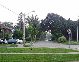
The Kingsway is a residential neighbourhood in Toronto, Ontario, Canada. It is bounded by Bloor Street to the south, Dundas Street to the north, the Mimico Creek to the west and the Humber River to the east. The neighbourhood was officially known as Kingsway Park, which later became replaced by its nickname the Kingsway. In this neighbourhood, the Kingsway specifically refers to a two-lane road beginning in the south-east corner of the neighbourhood extending northerly in a north-west direction past Dundas Street.

<span class="mw-page-title-main">New Toronto</span> Neighbourhood in Toronto, Ontario, Canada

New Toronto is a neighbourhood and former municipality in Toronto, Ontario, Canada. It is located in the south-west area of Toronto, along Lake Ontario. The Town of New Toronto was established in 1890, and was designed and planned as an industrial centre by a group of industrialists from Toronto who had visited Rochester, New York. New Toronto was originally a part of the Township of Etobicoke. It was an independent municipality from 1913 to 1967, being one of the former 'Lakeshore Municipalities' amalgamated into the Borough of Etobicoke, and eventually amalgamated into Toronto. The neighbourhood has retained the name.

<span class="mw-page-title-main">Humber River—Black Creek (federal electoral district)</span> Federal electoral district in Ontario, Canada

Humber River—Black Creek is a federal electoral district in Toronto, Ontario, Canada, that has been represented in the House of Commons of Canada from 1867 to 1904 and since 1917. Prior to the 2015 election, the riding was known as York West. The former name reflects the riding is in the former Township of York which is within the City of Toronto.

<span class="mw-page-title-main">Line 2 Bloor–Danforth</span> Rapid transit line in Toronto, Ontario

Line 2 Bloor–Danforth is a subway line in the Toronto subway system, operated by the Toronto Transit Commission (TTC). It has 31 stations and is 26.2 kilometres (16.3 mi) in length. It opened on February 26, 1966, and extensions at both ends were completed in 1968 and again in 1980.

<span class="mw-page-title-main">Mimico</span> Neighbourhood in Toronto, Ontario, Canada

Mimico is a neighbourhood in Toronto, Ontario, Canada, being located in the south-west area of Toronto on Lake Ontario. It is in the south-east corner of the former Township of Etobicoke, and was an independent municipality from 1911 to 1967.

<span class="mw-page-title-main">Bloor Street</span> Major thoroughfare in Toronto

Bloor Street is a major east–west residential and commercial thoroughfare in Toronto, Ontario, Canada. Bloor Street runs from the Prince Edward Viaduct, which spans the Don River Valley, westward into Mississauga where it ends at Central Parkway. East of the viaduct, Danforth Avenue continues along the same right-of-way. The street, approximately 25 kilometres (16 mi) long, contains a significant cross-sample of Toronto's ethnic communities. It is also home to Toronto's famous shopping street, the Mink Mile.

<span class="mw-page-title-main">Lawrence Avenue</span> Thoroughfare in Toronto, Ontario

Lawrence Avenue is a major east–west thoroughfare in Toronto, Ontario, Canada. It is divided into east and west portions by Yonge Street, the dividing line of east–west streets in Toronto.

<span class="mw-page-title-main">Eglinton Avenue</span> Road in Toronto and Mississauga, Canada

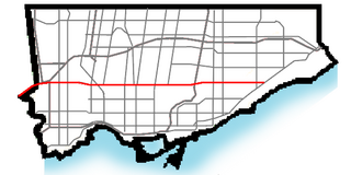
Eglinton Avenue is a major east–west arterial thoroughfare in Toronto and Mississauga in the Canadian province of Ontario. The street begins at Highway 407 at the western limits of Mississauga, as a continuation of Lower Baseline in Milton. It traverses the midsection of both cities and ends at Kingston Road. Eglinton Avenue is the only street to cross all six former cities and boroughs of Metropolitan Toronto.

<span class="mw-page-title-main">Kipling Avenue</span> Road in Toronto, Canada

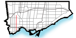
Kipling Avenue is a street in the cities of Toronto and Vaughan in Ontario, Canada. It is a concession road, 6 concessions (12 km) west from Yonge Street, and is a major north–south arterial road. It consists of three separate sections, with total combined length of 26.4 km. (16.4 mi.).

<span class="mw-page-title-main">History of the Toronto Transit Commission</span>

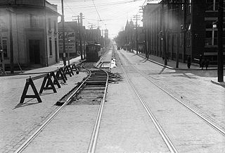
The history of public transportation in Toronto in Canada dates back to the middle 19th century under many different private companies, organizations and owners, which were all later unified as a single government-run entity during the 1920s.

<span class="mw-page-title-main">Richview, Toronto</span> Neighbourhood in Toronto, Ontario, Canada

Richview, formally known as Willowridge-Martingrove-Richview, is a neighbourhood in the city of Toronto, Ontario, Canada. It is bounded on the west by Highway 401 and on the north by the highway and by Dixon Road, Royal York Road on the east, and Eglinton Avenue West along the south. Richview was originally established as a postal village within the then-agricultural Etobicoke Township, which later became the suburb of Etobicoke.

<span class="mw-page-title-main">Islington-City Centre West</span> Neighbourhood in Toronto, Ontario, Canada

Islington-City Centre West is a commercial and residential neighbourhood in Toronto, Ontario, Canada. One of four central business districts outside Downtown Toronto, it is bounded by Rathburn Road to the north, Islington Avenue to the east, Bloor Street to the south, Mimico Creek to the west.

<span class="mw-page-title-main">The Queensway–Humber Bay</span> Neighbourhood in Toronto, Ontario, Canada

The Queensway–Humber Bay, known officially as Stonegate–Queensway, is a neighbourhood in the southwest of Toronto, Ontario, Canada. It is located in the southeast area of the former City of Etobicoke.

<span class="mw-page-title-main">Royal York Road</span> Thoroughfare in Toronto, Ontario

Royal York Road, historically known as Church Street or New Church Street, is a north-south arterial road in Toronto, Ontario, Canada. It is a concession road, 5 concessions (10 km) west of Yonge Street, and runs through many residential neighbourhoods, most notably Mimico and the Kingsway. It is classified as a "minor arterial" road by the city of Toronto.

<span class="mw-page-title-main">History of neighbourhoods in Toronto</span>

Throughout its history, Toronto has been a city divided into many districts and neighbourhoods. As the city has grown, new neighbourhoods have been created by expansion of the city into the countryside. Over time, the neighbourhoods within existing areas have also been altered and rearranged.

<span class="mw-page-title-main">East Danforth</span> Neighbourhood in Toronto, Ontario, Canada

East Danforth, also known as Danforth Village, is an informal neighbourhood in the east end of Toronto, Ontario, Canada. It is located on the eastern part of Danforth Avenue, from the eastern edge of Greektown by Greenwood Avenue to the boundary of Scarborough at Victoria Park Avenue. The area is covered by two business improvement associations, Danforth Village and Danforth Mosaic. To the north of the neighbourhood is Old East York, once a separate municipality, but today closely integrated into the area. The southern border is the railway tracks, beyond which is Leslieville and the Upper Beaches.

References

  1. "The Globe's Insider's City Guides: Toronto" John Allemang, Tralee Pearce. The Globe and Mail. Jun 11, 2003. pg. T.1
  2. 1 2 Toronto, City of (4 February 2024). "About Toronto Neighbourhoods". toronto.ca.
  3. "City of Toronto Residential Communities and Business Improvement Areas Map" (PDF). toronto.ca. Archived from the original (PDF) on 2006-01-03. Retrieved 2009-05-21.
  4. "Areas and Suburbs in Toronto | Expat Arrivals". Expat Arrivals. 2014-05-16. Retrieved 2017-04-23.
  5. New Zoning in Toronto MLS Brings Neighbourhood Names and Municipalities by Jamie Sarner, accessed on July 5, 2011.
  6. 1 2 MLS Zoning Change: TREB Introducing Friendly Community Names Archived 2011-07-11 at the Wayback Machine by ILoveToronto.com, accessed on July 5, 2011.
  7. Looking at Homes: Your Daily Listings by Jamie Sarner, accessed on July 5, 2011.
  8. TREB Zones & Regions Archived 2011-07-16 at the Wayback Machine by Toronto Real Estate Board, accessed on July 5, 2011.