Morningside Heights, Toronto

Last updated

Morningside Heights
Neighbourhood
Morningside Heights 2023.jpg
Aerial view of Morningside Heights, Toronto in 2023
Morningside Heights map.PNG
Coordinates: 43°49′12″N79°13′06″W / 43.82000°N 79.21833°W / 43.82000; -79.21833
CountryCanada
Province Ontario
City Toronto
Established1850 Scarborough Township
Changed municipality1998 Toronto from City of Scarborough
Developed2002 (Subdivision)
Government
   MP Shaun Chen (Scarborough North) | Gary Anandasangaree Scarborough-Rouge Park
   MPP Raymond Cho (Scarborough North) | Vijay Thanigasalam Scarborough-Rouge Park
   Councillor Vacant
Websitewww.mhna.ca

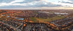
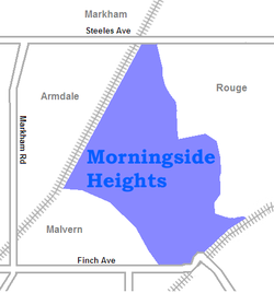
Morningside Heights is a residential neighbourhood in Toronto, Ontario, Canada. It is located in the northeast corner of the city, in the district of Scarborough, just north of the neighbourhood of Malvern and west of Rouge Park and the Rouge. The subdivision, comprising approximately 750 acres (3.0 km2), was one of the last large tracts of undeveloped land within the City of Toronto, located between Finch Avenue East and Steeles Avenue East, from Tapscott Road to the Rouge River. [1]

Contents

The area is named after Morningside Avenue, which was extended north into the neighbourhood. The northern section of Morningside Heights is also known as Brookside. The community is divided, north and south, by hydro lines that cut across the development. The name Brookside originates from a golf course that was once on the site, northeast of the intersection of Oasis Boulevard and Seasons Drive.

Local residents formed the Morningside Heights Neighbourhood Association in 2015. In 2018, it was registered with the Ontario Ministry of Government and Consumer Services as a not-for-profit group.

History

Residential developments took place in the neighbourhood in the early 21st century. Rouge Park.JPG
Residential developments took place in the neighbourhood in the early 21st century.

The first phase of Morningside Heights development took place in 2002. The last houses to be constructed were completed in 2015. The area has proved to be very diverse, with a large number of South Asian (predominantly Sri Lankan Tamils, Pakistanis, and Indians), Caribbean and Filipino residents among others.

The neighbourhood is entirely residential with no commercial developments, although it contains unused land intended for future developments. The local homeowners association was successful in stopping the planned proposal for a gas station to be built at the southwest corner of Neilson Road and Morningside Avenue, citing potential health risks.[ citation needed ]

Education

Two public school boards operate schools in Morningside Heights, the separate Toronto Catholic District School Board (TCDSB), and the secular Toronto District School Board (TDSB).

TDSB operates two public elementary schools (JK-Grade 8) in the neighbourhood, Brookside Public School, and Thomas Wells Public School. Brookside sits on much of the former golf course and is surrounded by single-detached housing. Designed by Teeple Architects, this school was opened in September 2007. Also this school has achieved the LEED Gold" certification. Students attending Brookside requires school uniform. [2] Thomas Wells Public School, named after Thomas Leonard Wells, was opened in September 2005. This school was the first LEED Silver certified elementary school in Canada. Currently the school has over 700 students. this was derived from the street that The school is located on Nightstar Road. [3]

Brookside Public School is one of three public elementary schools situated in Morningside Heights. Brookside Child Care Centre & Brookside Public School 2023.jpg
Brookside Public School is one of three public elementary schools situated in Morningside Heights.

TCDSB operates one public elementary school in the neighbourhood, Blessed Pier Giorgio Frassati Catholic School, located adjacent to Brookside Public School. The school opened in September 2013. The building itself is divided into public and school use areas, and includes a multi-purpose room available for specialty programs and after hours use. The building is barrier free and include an elevator and barrier free washrooms. The school includes purpose built classrooms for Junior and Senior Kindergarten, and features a well-defined, student-friendly playground areas that combine hard and soft landscaping. Environmentally friendly by design, the building incorporates enhanced access to natural light, particularly in classrooms, water efficient landscaping, enhanced site storm water management, an energy efficient building envelope which includes high performance windows and a cool white roof to reduce heat gain through the roof. The school also requires students to wear uniforms. The school is named after Pier Giorgio Frassati.

Neither school board operates a secondary school in the neighbourhood, with TCDSB/TDSB secondary school students residing in Morningside Heights attending institutions in other neighbourhoods. The French-based public secular school board, Conseil scolaire Viamonde, and it separate counterpart, Conseil scolaire catholique MonAvenir also offer schooling to applicable residents of Morningside, although they do not operate a school in the neighbourhood, with CSCM/CSV students attending schools situated in other neighbourhoods in Toronto.

Transportation

View of Finch and Morningside Avenue, two major roadways in the neighbourhood. Morningside Ave at Finch.JPG
View of Finch and Morningside Avenue, two major roadways in the neighbourhood.

Major east-west roadways located in Morningside Heights includes Finch Avenue, and Steeles Avenue, with the latter road acting as the boundary for the neighbourhood. The northern end of Morningside Avenue is also located at Morningside Heights

Public transportation

Public transportation is provided by the Toronto Transit Commission's (TTC) bus system. The 133 Neilson links the neighbourhood to Scarborough Centre. [4] The 53A Steeles East provides additional service to the northeast section of the area, while travelling as far as Finch station in North York. [5] The 939C Finch Express provides express bus service to Finch station during weekday rush hours.

Services

The area is served by Toronto Fire Services Stations 211 and 212, Toronto Police Service 42 Division and Toronto Paramedic Service Station 25 and 27.

Related Research Articles

<span class="mw-page-title-main">Jane and Finch</span> Neighbourhood in Toronto, Ontario, Canada

Jane and Finch is a neighbourhood located in the northwest end of Toronto, Ontario, Canada, in the district of North York. Centred at the intersection of Jane Street and Finch Avenue West, the area is roughly bounded by Highway 400 to the west, Black Creek to the east, Sheppard Avenue to the south, and Steeles Avenue to the north.

<span class="mw-page-title-main">Newtonbrook</span> Neighbourhood of Toronto

Newtonbrook is a neighbourhood in Toronto, Ontario, Canada. It is located in the area around Yonge Street and Finch Avenue in the district of North York between the east and west branches of the Don River. Officially, the area is divided into two neighbourhoods; Newtonbrook West and Newtonbrook East.

<span class="mw-page-title-main">Malvern, Toronto</span> Neighbourhood in Toronto, Ontario, Canada

Malvern is a neighbourhood in the city of Toronto, Ontario, Canada, with a population of 44,315. It is located in the northeast corner of the city.

<span class="mw-page-title-main">Willowdale, Toronto</span> Neighbourhood in Toronto, Ontario, Canada

Willowdale is a neighbourhood in the city of Toronto, Ontario, Canada, located in the district of North York. It developed from three postal villages: Newtonbrook, Willowdale and Lansing.

<span class="mw-page-title-main">Humber Summit</span> Neighbourhood in Toronto, Ontario, Canada

Humber Summit is a neighbourhood in Toronto, Ontario, Canada. It is one of the northernmost neighbourhoods in Toronto, located in the North York district of the city. It is bounded by Steeles Avenue to the north, Highway 400 to the east, Finch Avenue to the south, and follows the Humber River to the west.

<span class="mw-page-title-main">Humbermede</span> Neighbourhood in Toronto, Ontario, Canada

Humbermede, often called Emery, is a neighbourhood of Toronto, Ontario, Canada. Humbermede, like many of the "Humber" neighbourhoods in the city, gets its name from the Humber River. It is bounded on the west by the Humber River, on the north by Finch Avenue West, on the east by the Highway 400 and on the south by Sheppard Avenue West.

<span class="mw-page-title-main">York University Heights</span> Neighbourhood in Toronto, Ontario, Canada

York University Heights, also known as Northwood Park, is a neighbourhood in Toronto, Ontario, Canada. It is one of Toronto's northernmost neighbourhoods, located along the northern boundary of Steeles Avenue in the former city of North York. The neighbourhood is so named because it contains the main campus of York University. This area is most popular with immigrants of Italian and Chinese descent who have established communities in the area. It is located between Sheppard Avenue and Steeles Avenue east of Black Creek.

<span class="mw-page-title-main">Yorkdale–Glen Park</span> Neighbourhood in Toronto, Ontario, Canada

Yorkdale–Glen Park is a neighbourhood in the city of Toronto, Ontario, Canada, located in the former suburb of North York. It is bounded by Highway 401 to the north, Allen Road to the east, a line south of Stayner Avenue to the south, and the CNR tracks to the west.

<span class="mw-page-title-main">Lawrence Manor</span> Neighbourhood in Toronto, Ontario, Canada

Lawrence Manor is a neighbourhood in the city of Toronto, Ontario, Canada. This neighbourhood is bounded by Bathurst Street on the east, Highway 401 to the north, the Allen to the west, and Lawrence Avenue to the south. The western side of the area borders along Bathurst Heights and the large public housing project.

<span class="mw-page-title-main">Clanton Park, Toronto</span> Neighbourhood in Toronto, Ontario, Canada

Clanton Park is a neighbourhood in Toronto, Ontario, Canada. Located in the district of North York, it is part of federal and provincial electoral district York Centre, and Toronto electoral wards 9: York Centre (West) and 10: York Centre (East). In 2016, it had a population of 16,472, a 12.7% rise from 2011.

<span class="mw-page-title-main">Westminster-Branson</span> Neighbourhood in Toronto, Ontario, Canada

Westminster-Branson is a neighbourhood in the city of Toronto, Ontario, Canada. It is in the northernmost part of the city within the area of North York.

<span class="mw-page-title-main">Pleasant View, Toronto</span> Neighbourhood in Toronto, Ontario, Canada

Pleasant View is a neighbourhood in the city of Toronto, Ontario, Canada that is located in the district of North York at the northern end of the city. It is bordered by Victoria Park to the East, Sheppard Avenue to the South, Highway 404 to the west and the Finch hydro corridor to the north. The neighbourhood is home to several high-rise apartment and condominium buildings, such as The Clippers.

<span class="mw-page-title-main">Don Valley Village</span> Neighbourhood in Toronto, Ontario, Canada

Don Valley Village is a neighbourhood in the city of Toronto, Ontario, Canada. It is located in the former suburb of North York. Located north of Highway 401 and bisected by Don Mills Road, it is bounded by Sheppard Avenue to the south, Leslie Street to the west, Finch Avenue to the north and Highway 404 to the east. Like the nearby Don River Valley, the neighbourhood has hill and dale topography.

<span class="mw-page-title-main">Bayview Woods-Steeles</span> Neighbourhood in Toronto, Ontario, Canada

Bayview Woods-Steeles is a neighbourhood located in the northern tip of the city of Toronto, Ontario, Canada in the district of North York. It is part of federal and provincial electoral district Don Valley North, and Toronto electoral ward 17: Don Valley North. In 2006, it had a population of 13,295. The area is divided by a series of ravines, and is often not considered a neighbourhood unto itself. Rather the sections are more often divided between the neighbouring areas of Hillcrest Village, Bayview Village, and Newtonbrook.

<span class="mw-page-title-main">Clairlea</span> Neighbourhood in Toronto, Ontario, Canada

Clairlea is a safe, quiet, middle to upper-middle income neighbourhood in Toronto, Ontario, Canada that features well treed streets and detached homes with large backyards. The neighbourhood is located in east Toronto just east of Victoria Park Avenue.

<span class="mw-page-title-main">Rouge, Toronto</span> Neighbourhood in Toronto, Ontario, Canada

Rouge is a neighbourhood in the northeastern area of Toronto, Ontario, within the former city of Scarborough. It is Toronto's largest neighbourhood by surface area; however, unlike other neighbourhoods, most of its area remains undeveloped, as the neighbourhood is adjacent to Rouge National Urban Park.

<span class="mw-page-title-main">Morningside, Toronto</span> Neighbourhood in Toronto, Ontario, Canada

Morningside, also known as Seven Oaks, is a suburban neighbourhood in the city of Toronto, Ontario, Canada. It is located to the north-east of downtown Toronto, in the suburb of Scarborough. Morningside is bordered by Highway 401 to the north, Morningside Avenue to the east, West Highland Creek and Lawrence Avenue to the south and Scarborough Golf Club Road to the west.

<span class="mw-page-title-main">Woburn, Toronto</span> Neighbourhood in Toronto, Ontario, Canada

Woburn is a neighbourhood located in eastern Toronto, Ontario, Canada, in the former suburb of Scarborough. Woburn is bordered by Highway 401 to the north, Orton Park Road to the east, Lawrence Avenue to the south, and McCowan Road to the west.

<span class="mw-page-title-main">Highland Creek, Toronto</span> Neighbourhood in Toronto, Ontario, Canada

Highland Creek is a neighbourhood in eastern Toronto, Ontario, Canada. It is located along the southern portion of the river of the same name in the former suburb of Scarborough. To the east are the neighbourhoods of Port Union and West Rouge, to the west West Hill and Woburn, and to the south Centennial Scarborough.

<span class="mw-page-title-main">Armour Heights</span> Neighbourhood in Toronto, Ontario, Canada

Armour Heights is a neighbourhood in Toronto, Ontario, Canada, in the district of North York. It is bounded by Wilson Avenue to the south, Bathurst Street to the west, and the west branch of the Don River to the north and east. Highway 401 cuts through the centre of the neighbourhood.

References

  1. "Morningside Heights Community Development" (PDF). Archived from the original (PDF) on 2011-07-06. Retrieved 2009-01-14.
  2. http://www.tdsb.on.ca/profiles/4801.pdf [ bare URL PDF ]
  3. http://www.tdsb.on.ca/profiles/4799.pdf [ bare URL PDF ]
  4. "TTC Map of 133 Neilson". www.ttc.ca. Retrieved Aug 19, 2019.
  5. "TTC Map of 53 Steeles East". www.ttc.ca. Retrieved Aug 19, 2019.