Bearing (navigation)

Last updated
A standard Brunton compass, used commonly by geologists and surveyors to obtain a bearing in the field Brunton.JPG
A standard Brunton compass, used commonly by geologists and surveyors to obtain a bearing in the field

In navigation, bearing or azimuth is the horizontal angle between the direction of an object and north or another object. The angle value can be specified in various angular units, such as degrees, mils, or grad. More specifically:

Contents

Alternatively, the US Army defines the bearing from point A to point B as the smallest angle between the ray AB and either north or south, whichever is closest. The bearing is expressed in terms of 2 characters and 1 number: first, the character is either N or S; next is the angle numerical value; third, the character representing the perpendicular direction, either E or W. The bearing angle value will always be less than 90 degrees. [1] For example, if Point B is located exactly southeast of Point A, the bearing from Point A to Point B is "S 45° E". [3] For example, if the bearing between Point A and Point B is S 45° E, the azimuth between Point A and Point B is 135°. [1] [3]

Azimuths and bearings. Azimuths and bearings.png
Azimuths and bearings.

Types

Absolute

A compass rose, showing absolute bearings in degrees. Compass-rose-32-pt.svg
A compass rose, showing absolute bearings in degrees.

In nautical navigation the absolute bearing is the clockwise angle between north and an object observed from the vessel.

If the north used as reference is the true geographical north then the bearing is a true bearing whereas if the reference used is magnetic north then the bearing is a magnetic bearing. An absolute bearing is measured with a bearing compass.

The measurement of absolute bearings of fixed landmarks and other navigation aids is useful for the navigator because this information can be used on the nautical chart together with simple geometrical techniques to aid in determining the position of the vessel.

A grid bearing (also known as grid azimuth) is measured in relation to the fixed horizontal reference plane of grid north, that is, using the direction northwards along the grid lines of the map projection as a reference point.

A compass bearing, as in vehicle or marine navigation, is measured in relation to the magnetic compass of the navigator's vehicle or vessel (if aboard ship). It should be very close to the magnetic bearing. The difference between a magnetic bearing and a compass bearing is the deviation caused to the compass by ferrous metals and local magnetic fields generated by any variety of vehicle or shipboard sources (steel vehicle bodies/frames or vessel hulls, ignition systems, etc.) [4]

Relative

In nautical navigation the relative bearing of an object is the clockwise angle from the heading of the vessel to a straight line drawn from the observation station on the vessel to the object.

The relative bearing is measured with a pelorus or other optical and electronic aids to navigation such as a periscope, sonar system, and radar systems. Since World War II, relative bearings of such diverse point sources have been and are calibrated carefully to one another. The United States Navy operates a special range off Puerto Rico and another on the west coast to perform such systems integration. Relative bearings then serve as the baseline data for converting relative directional data into true bearings (N-S-E-W, relative to the Earth's true geography). By contrast, Compass bearings have a varying error factor at differing locations about the globe, and are less reliable than the compensated or true bearings.

The measurement of relative bearings of fixed landmarks and other navigational aids is useful for the navigator because this information can be used on the nautical chart together with simple geometrical techniques to aid in determining the vessel's position, speed, course, etc.

The measurement of relative bearings of other vessels and objects in movement is useful to the navigator in avoiding the danger of collision. For example:

Examples

Piloting
A bearing can be taken on another vessel to aid piloting. If the two vessels are travelling towards each other and the relative bearing remains the same over time, there is likelihood of collision and action needs to be taken by one or both vessels to prevent this from happening.
Warfare

A bearing can be taken to a fixed or moving object in order to target it with gunfire or missiles. This is mainly used by ground troops when planning on using an air-strike on the target.

Search and rescue
A bearing can be taken to a person or vessel in distress in order to go to their aid.

Usages

The bearing between Cape Town and Melbourne along the geodesic (the shortest route) changes from 141deg to 42deg. Azimuthal orthographic projection and Miller cylindrical projection. Bearing and azimuth along the geodesic.png
The bearing between Cape Town and Melbourne along the geodesic (the shortest route) changes from 141° to 42°. Azimuthal orthographic projection and Miller cylindrical projection.

There are several methods used to measure navigation bearings including:

  1. In land navigation, a 'bearing' is ordinarily calculated in a clockwise direction starting from a reference direction of 0° and increasing to 359.9 degrees. [5] Measured in this way, a bearing is referred to as an azimuth by the US Army but not by armies in other English speaking nations, which use the term bearing. [6] If the reference direction is north (either true north, magnetic north, or grid north), the bearing is termed an absolute bearing. In a contemporary land navigation context, true, magnetic, and grid bearings are always measured in this way, with true north, magnetic north, or grid north being 0° in a 360-degree system. [5]
  2. In aircraft navigation, an angle is normally measured from the aircraft's track or heading, in a clockwise direction. If the aircraft encounters a target that is not ahead of the aircraft and not on an identical track, then the angular bearing to that target is called a relative bearing.[ clarification needed ] [7]
  3. In marine navigation, starboard bearings are 'green' and port bearings are 'red'. Thus, in ship navigation, a target directly off the starboard side would be 'Green090' or 'G090'. [8] This method is only used for a relative bearing. A navigator on watch does not always have a corrected compass available with which to give an accurate bearing. If available, the bearing might not be numerate. Therefore, every forty-five degrees of direction from north on the compass was divided into four 'points'. Thus, 32 points of 11.25° each makes a circle of 360°. An object at 022.5° relative would be 'two points off the starboard bow', an object at 101.25° relative would be 'one point abaft the starboard beam' and an object at 213.75° relative would be 'three points on the port quarter'. This method is only used for a relative bearing.
  4. An informal method of measuring a relative bearing is by using the 'clock method'. In this method, the direction a vessel, aircraft or object is measured as if a clock face is laid over the vessel or aircraft, with the number twelve pointing forward. Something straight ahead is at 'twelve o'clock', while something directly off to the right is at 'three o'clock'. This method is only used for a relative bearing. [9]
  5. In land surveying, a bearing is the clockwise or counterclockwise angle between north or south and a direction. For example, bearings are recorded as N57°E, S51°E, S21°W, N87°W, or N15°W. In surveying, bearings can be referenced to true north, magnetic north, grid north (the Y axis of a map projection), or a previous map, which is often a historical magnetic north.[ citation needed ]
  6. If navigating by gyrocompass, the reference direction is true north, in which case the terms true bearing and geodetic bearing are used.
  7. In stellar navigation, the reference direction is that of the North Star, Polaris.
  8. In satellite broadcasting, a bearing is the combination of antenna azimuth and elevation required to point (aim) a satellite dish antenna in a given direction. The bearing for geostationary satellites is constant. The bearing for polar-orbiting satellites varies continuously.
A and B are near the North Pole and facing each other. Though A is facing east, B is not facing west. If B were to face west, her direction (dashed arrow) would be tangential to her latitude circle (dashed circle). Only on the equator is it true that if A faces east and B faces west that they can face each other. Polar bear bearing.svg
A and B are near the North Pole and facing each other. Though A is facing east, B is not facing west. If B were to face west, her direction (dashed arrow) would be tangential to her latitude circle (dashed circle). Only on the equator is it true that if A faces east and B faces west that they can face each other.

Arcs

Moving from A to B along a great circle can be considered as always going in the same direction (the direction of B), but not in the sense of keeping the same bearing, which applies when following a rhumb line. Accordingly, the direction at A of B, expressed as a bearing, is not in general the opposite of the direction at B of A (when traveling on the great circle formed by A and B). For example, assume A and B in the northern hemisphere have the same latitude, and at A the direction to B is east-northeast. Then going from A to B, one arrives at B with the direction east-southeast, and conversely, the direction at B of A is west-northwest.

Latitude circles near the North Pole are shown in red. For A and B to face each other, A has to look East but B not to the West. If B were to look West, she would see a bear eyeing her as his next meal. For A and C to face each other, both would have to face North. Polar bears near the Pole.PNG
Latitude circles near the North Pole are shown in red. For A and B to face each other, A has to look East but Bnot to the West. If B were to look West, she would see a bear eyeing her as his next meal. For A and C to face each other, both would have to face North.

To "keep to a bearing" is not, in general, the same as going in a straight direction along a great circle. Conversely, one can keep to a great circle and the bearing may change. Thus the bearing of a straight path crossing the North Pole changes abruptly at the Pole from North to South. When travelling East or West, it is only on the Equator that one can keep East or West and be going straight (without the need to adjust). Anywhere else, maintaining latitude requires a change in direction, requires adjustment. This change in direction becomes increasingly negligible as one moves to a lower latitude

See also

Related Research Articles

<span class="mw-page-title-main">Navigation</span> Process of monitoring and controlling the movement of a craft or vehicle from one place to another

Navigation is a field of study that focuses on the process of monitoring and controlling the movement of a craft or vehicle from one place to another. The field of navigation includes four general categories: land navigation, marine navigation, aeronautic navigation, and space navigation.

<span class="mw-page-title-main">Compass</span> Instrument used for navigation and orientation

A compass is a device that shows the cardinal directions used for navigation and geographic orientation. It commonly consists of a magnetized needle or other element, such as a compass card or compass rose, which can pivot to align itself with magnetic north. Other methods may be used, including gyroscopes, magnetometers, and GPS receivers.

<span class="mw-page-title-main">Azimuth</span> Horizontal angle from north or other reference cardinal direction

An azimuth is the angular measurement in a spherical coordinate system which represents the horizontal angle from a cardinal direction, most commonly north.

<span class="mw-page-title-main">North</span> One of the four cardinal directions

North is one of the four compass points or cardinal directions. It is the opposite of south and is perpendicular to east and west. North is a noun, adjective, or adverb indicating direction or geography.
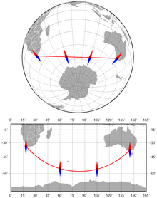
<span class="mw-page-title-main">Magnetic declination</span> Angle on the horizontal plane between magnetic north and true north

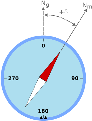
Magnetic declination is the angle between magnetic north and true north at a particular location on the Earth's surface. The angle can change over time due to polar wandering.

The basic principles of air navigation are identical to general navigation, which includes the process of planning, recording, and controlling the movement of a craft from one place to another.

<span class="mw-page-title-main">Non-directional beacon</span> Radio transmitter which emits radio waves in all directions, used as a navigational aid

A non-directional beacon (NDB) or non-directional radio beacon is a radio beacon which does not include inherent directional information. Radio beacons are radio transmitters at a known location, used as an aviation or marine navigational aid. NDB are in contrast to directional radio beacons and other navigational aids, such as low-frequency radio range, VHF omnidirectional range (VOR) and tactical air navigation system (TACAN).

<span class="mw-page-title-main">Automatic direction finder</span> Marine or aircraft radio-navigation instrument

An automatic direction finder (ADF) is a marine or aircraft radio-navigation instrument that automatically and continuously displays the relative bearing from the ship or aircraft to a suitable radio station. ADF receivers are normally tuned to aviation or marine NDBs operating in the LW band between 190 – 535 kHz. Like RDF units, most ADF receivers can also receive medium wave (AM) broadcast stations, though these are less reliable for navigational purposes.

<span class="mw-page-title-main">Points of the compass</span> Directional divisions marked on a compass

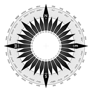
The points of the compass are a set of horizontal, radially arrayed compass directions used in navigation and cartography. A compass rose is primarily composed of four cardinal directions—north, east, south, and west—each separated by 90 degrees, and secondarily divided by four ordinal (intercardinal) directions—northeast, southeast, southwest, and northwest—each located halfway between two cardinal directions. Some disciplines such as meteorology and navigation further divide the compass with additional azimuths. Within European tradition, a fully defined compass has 32 "points".

Piloting or pilotage is the process of navigating on water or in the air using fixed points of reference on the sea or on land, usually with reference to a nautical chart or aeronautical chart to obtain a fix of the position of the vessel or aircraft with respect to a desired course or location. Horizontal fixes of position from known reference points may be obtained by sight or by radar. Vertical position may be obtained by depth sounder to determine depth of the water body below a vessel or by altimeter to determine an aircraft's altitude, from which its distance above the ground can be deduced. Piloting a vessel is usually practiced close to shore or on inland waterways. Pilotage of an aircraft is practiced under visual meteorological conditions for flight.

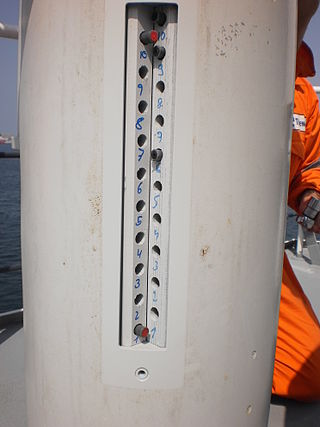
A lubber line, also known as a lubber's line, is a fixed line on a compass binnacle or radar plan position indicator display pointing towards the front of the ship or aircraft and corresponding to the craft's centerline.

<span class="mw-page-title-main">Pelorus (instrument)</span>

In marine navigation, a pelorus is a reference tool for maintaining bearing of a vessel at sea. It is a "simplified compass" without a directive element, suitably mounted and provided with vanes to permit observation of relative bearings.

In astronomical navigation, the intercept method, also known as Marcq St. Hilaire method, is a method of calculating an observer's position on Earth (geopositioning). It was originally called the azimuth intercept method because the process involves drawing a line which intercepts the azimuth line. This name was shortened to intercept method and the intercept distance was shortened to 'intercept'.

<span class="mw-page-title-main">Diver navigation</span> Underwater navigation by scuba divers

Diver navigation, termed "underwater navigation" by scuba divers, is a set of techniques—including observing natural features, the use of a compass, and surface observations—that divers use to navigate underwater. Free-divers do not spend enough time underwater for navigation to be important, and surface supplied divers are limited in the distance they can travel by the length of their umbilicals and are usually directed from the surface control point. On those occasions when they need to navigate they can use the same methods used by scuba divers.

Position resection and intersection are methods for determining an unknown geographic position by measuring angles with respect to known positions. In resection, the one point with unknown coordinates is occupied and sightings are taken to the known points; in intersection, the two points with known coordinates are occupied and sightings are taken to the unknown point.

<span class="mw-page-title-main">Rayleigh sky model</span>

The Rayleigh sky model describes the observed polarization pattern of the daytime sky. Within the atmosphere, Rayleigh scattering of light by air molecules, water, dust, and aerosols causes the sky's light to have a defined polarization pattern. The same elastic scattering processes cause the sky to be blue. The polarization is characterized at each wavelength by its degree of polarization, and orientation.

<span class="mw-page-title-main">Clock position</span> Relative direction using a dial

A clock position, or clock bearing, is the direction of an object observed from a vehicle, typically a vessel or an aircraft, relative to the orientation of the vehicle to the observer. The vehicle must be considered to have a front, a back, a left side and a right side. These quarters may have specialized names, such as bow and stern for a vessel, or nose and tail for an aircraft. The observer then measures or observes the angle made by the intersection of the line of sight to the longitudinal axis, the dimension of length, of the vessel, using the clock analogy.

<span class="mw-page-title-main">Heading (navigation)</span> Compass direction

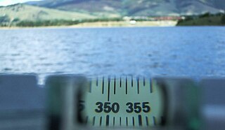
In navigation, the heading of a vessel or aircraft is the compass direction in which the craft's bow or nose is pointed. Note that the heading may not necessarily be the direction that the vehicle actually travels, which is known as its course or track. Any difference between the heading and course is due to the motion of the underlying medium, the air or water, or other effects like skidding or slipping. The difference is known as the drift, and can be determined by the wind triangle. At least seven ways to measure the heading of a vehicle have been described.

<span class="mw-page-title-main">Azimuth compass</span> Nautical instrument

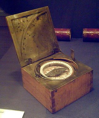
An azimuth compass is a nautical instrument used to measure the magnetic azimuth, the angle of the arc on the horizon between the direction of the Sun or some other celestial object and the magnetic north. This can be compared to the true azimuth obtained by astronomical observation to determine the magnetic declination, the amount by which the reading of a ship's compass must be adjusted to obtain an accurate reading. Azimuth compasses were important in the period before development of the reliable chronometers needed to determine a vessel's exact position from astronomical observations.

<span class="mw-page-title-main">Prismatic compass</span> Navigation and surveying instrument to measure magnetic bearing

A prismatic compass is a navigation and surveying instrument which is extensively used to find out the bearing of the traversing and included angles between them, waypoints and direction. Compass surveying is a type of surveying in which the directions of surveying lines are determined with a magnetic compass, and the length of the surveying lines are measured with a tape or chain or laser range finder. The compass is generally used to run a traverse line. The compass calculates bearings of lines with respect to magnetic needle. The included angles can then be calculated using suitable formulas in case of clockwise and anti-clockwise traverse respectively. For each survey line in the traverse, surveyors take two bearings that is fore bearing and back bearing which should exactly differ by 180° if local attraction is negligible. The name Prismatic compass is given to it because it essentially consists of a prism which is used for taking observations more accurately.

References

  1. 1 2 3 U.S. Army, Advanced Map and Aerial Photograph Reading, Headquarters, War Department, Washington, D.C. (17 September 1941), pp. 24-25
  2. Rutstrum, Carl (2000). The Wilderness Route Finder. University of Minnesota Press. p. 194. ISBN   0-8166-3661-3.
  3. 1 2 U.S. Army, Map Reading and Land Navigation, FM 21-26, Headquarters, Dept. of the Army, Washington, D.C. (28 March 1956), ch. 3, pp. 69-70
  4. Estopinal, Stephen V. (2009). A Guide to Understanding Land Surveys. John Wiley & Sons. p. 35. ISBN   978-0-470-23058-9.
  5. 1 2 Keay, pp. 133-134
  6. U.S. Army, Map Reading and Land Navigation, FM 21-26, Headquarters, Dept. of the Army, Washington, D.C. (7 May 1993), ch. 6, p. 2
  7. "Relative Bearing - an overview | ScienceDirect Topics". www.sciencedirect.com. Retrieved 2022-07-04.
  8. This method is used by the Royal Navy and the Royal Australian Navy in accordance with the Admiralty Manual of Navigation, BR45.
  9. Gilzean, Don. "Bearings". Navigation in a Modern World. Retrieved 2022-07-04.

Further reading