Heading (navigation)

Last updated
This wind triangle shows a jet airliner's heading towards point B (HDG, in black; TAS=True Air Speed) and its course towards C (TR, track, in blue; GS=Ground Speed). The drift angle (shaded red) is due to the wind velocity (W/V, in green). Wind drift.png
This wind triangle shows a jet airliner's heading towards point B (HDG, in black; TAS=True Air Speed) and its course towards C (TR, track, in blue; GS=Ground Speed). The drift angle (shaded red) is due to the wind velocity (W/V, in green).

In navigation, the heading of a vessel or aircraft is the compass direction in which the craft's bow or nose is pointed. Note that the heading may not necessarily be the direction that the vehicle actually travels, which is known as its course or track. Any difference between the heading and course is due to the motion of the underlying medium, the air or water, or other effects like skidding or slipping. The difference is known as the drift, and can be determined by the wind triangle . At least seven ways to measure the heading of a vehicle have been described. [1]

Contents

Notation

Heading is typically based on cardinal directions, so 0° (or 360°) indicates a direction toward true north, 90° true east, 180° true south, and 270° true west. [1]

TVMDC

Heading and track (A to B)
1 - True North
2 - Heading, the direction the vessel is "pointing towards"
3 - Magnetic north, which differs from true north by the magnetic variation.
4 - Compass north, including a two-part error; the magnetic variation (6) and the ship's own magnetic field (5)
5 - Magnetic deviation, caused by vessel's magnetic field.
6 - Magnetic variation, caused by variations in Earth's magnetic field.
7 - Compass heading or compass course, before correction for magnetic deviation or magnetic variation.
8 - Magnetic heading, the compass heading corrected for magnetic deviation but not magnetic variation; thus, the heading reliative to magnetic north.
9, 10 - Effects of crosswind and tidal current, causing the vessel's track to differ from its heading.
A, B - Vessel's track. Course (navigation).svg
Heading and track (A to B)
1 - True North
2 - Heading, the direction the vessel is "pointing towards"
3 - Magnetic north, which differs from true north by the magnetic variation.
4 - Compass north, including a two-part error; the magnetic variation (6) and the ship's own magnetic field (5)
5 - Magnetic deviation, caused by vessel's magnetic field.
6 - Magnetic variation, caused by variations in Earth's magnetic field.
7 - Compass heading or compass course, before correction for magnetic deviation or magnetic variation.
8 - Magnetic heading, the compass heading corrected for magnetic deviation but not magnetic variation; thus, the heading reliative to magnetic north.
9, 10 - Effects of crosswind and tidal current, causing the vessel's track to differ from its heading.
A, B - Vessel's track.

TVMDC,AW is a mnemonic for converting from true heading, to magnetic and compass headings. TVMDC is a mnemonic initialism for true heading, variation, magnetic heading, deviation, compass heading, add westerly. The most common use of the TVMDC method is deriving compass courses during nautical navigation from maps. The inverse correction from compass heading to true heading is "CDMVTAE", with compass heading, deviation, magnetic heading, variation, true heading, add easterly The most common use of the CDMVTAE rule is to convert compass headings to map headings.

Background

The Geographic North Pole around which the Earth rotates is not in exactly the same position as the Magnetic North Pole. From any position on the globe, a direction can be determined to either the Geographic North Pole or to the Magnetic North Pole. These directions are expressed in degrees from 0–360°, and also fractions of a degree. The differences between these two directions at any point on the globe is magnetic variation (also known as magnetic declination, but for the purposes of the mnemonic, the term 'variation' is preferred). When a compass is installed in a vehicle or vessel, local anomalies of the vessel can introduce error into the direction that the compass points. The difference between the local Magnetic North and the direction that the compass indicates as north is known as magnetic deviation.

Determine variation in North America

Magnetic variation (also known as magnetic declination) is different depending on the geographic position on the globe. The Magnetic North Pole is currently in Northern Canada and is moving generally south. A straight line can be drawn from the Geographic North Pole, down to the Magnetic North Pole and then continued straight down to the equator. This line is known as the agonic line, and the line is also moving. In the year 1900, the agonic line passed roughly through Detroit and then was east of Florida. It currently passes roughly west of Chicago, IL, and through New Orleans, LA. If a navigator is located on the agonic line, then variation is zero: the Magnetic North Pole and the Geographic North Pole appear to be directly in line with each other. If a navigator is east of the agonic line, then the variation is westward; magnetic north appears slightly west of the Geographic North Pole. If a navigator is west of the agonic line, then the variation is eastward; the Magnetic North Pole appears to the east of the Geographic North Pole. The farther the navigator is from the agonic line, the greater the variation. The local magnetic variation is indicated on NOAA nautical charts at the center of the compass rose. The magnetic variation is indicated along with the year of that variation. The annual increase or decrease of the variation is also usually indicated, so that the variation for the current year can be calculated.

Determine deviation

A compass installed in a vehicle or vessel has a certain amount of error caused by the magnetic properties of the vessel. This error is known as compass deviation. The magnitude of the compass deviation varies greatly depending upon the local anomalies created by the vessel. A fiberglass recreational vessel will generally have much less compass deviation than a steel-hulled vessel. Electrical wires carrying current have a small magnetic field around them and can cause deviation. Any type of magnet, such as found in a speaker can also cause large magnitudes of compass deviation. The error can be corrected using a deviation table. Deviation tables are very difficult to create. Once a deviation table is established, it is only good for that particular vessel, with that particular configuration. If electrical wires are moved or anything else magnetic (speakers, electric motors, etc.) are moved, the deviation table will change. All deviations in the deviation table are indicated west or east. If the compass is pointing west of the Magnetic North Pole, then the deviation is westward. If the compass is pointing east of the Magnetic North Pole, then the deviation is eastward.

Formula

Calculating TVMDC is done with simple arithmetic. First arrange the values vertically:

The formula is always added moving down, and subtracted when moving up. The most complicated part is determining if the values are positive or negative. The True, Magnetic, and Compass values are directions on the compass, they must always be a positive number between 0–360. Variation and Deviation can be positive or negative. If either Variation or Deviation is westward, then the values are entered into the equation as positive. If the Variation or Deviation is eastward, then the values are entered into the formula as a negative. Some use the mnemonic: True Virgins Make Dull Companions - Going downward Add Whiskey (or West). An alternative, working the opposite direction: Can Dead Men Vote Twice.

Examples

True course is 120°, the Variation is 5° West, and the Deviation is 1° West.

  • T: 120°
  • V: +5°
  • M: 125°
  • D: +1°
  • C: 126°

Therefore, to achieve a true course of 120°, one should follow a compass heading of 126°.

True course is 120°, the Variation is 5° East and the Deviation is 1° East.

  • T: 120°
  • V: −5°
  • M: 115°
  • D: −1°
  • C: 114°

True course is 035°, the Variation is 4° West and the Deviation is 1° East.

  • T: 035°
  • V: +4°
  • M: 039°
  • D: −1°
  • C: 038°

True course is 306°, the Variation is 4° East and the Deviation is 11° West.

  • T: 306°
  • V: −4°
  • M: 302°
  • D: +11°
  • C: 313°

Reverse

The formula can also be calculated in reverse. The formula is subtracted when moving up.

Compass course is 093°, the Deviation is 4° West and the Variation is 3° West.

  • T: 086°
  • V: -3°
  • M: 089°
  • D: -4°
  • C: 093°

Thus, when following a compass course of 093°, the true course is 086°.

CDMVT

Aviation: CDMVT Can Dead Man Vote Twice: Mnemonic. Easy way to calculate compass magnetic or true north is maintaining the original signs for variation and deviation (+ for east and -for west): C+(Var)= M+(Dev)= T / T-(Dev)= M-(Var)= C

See also

Related Research Articles

<span class="mw-page-title-main">Navigation</span> Process of monitoring and controlling the movement of a craft or vehicle from one place to another

Navigation is a field of study that focuses on the process of monitoring and controlling the movement of a craft or vehicle from one place to another. The field of navigation includes four general categories: land navigation, marine navigation, aeronautic navigation, and space navigation.

<span class="mw-page-title-main">Compass</span> Instrument used for navigation and orientation

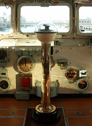
A compass is a device that shows the cardinal directions used for navigation and geographic orientation. It commonly consists of a magnetized needle or other element, such as a compass card or compass rose, which can pivot to align itself with magnetic north. Other methods may be used, including gyroscopes, magnetometers, and GPS receivers.

<span class="mw-page-title-main">North</span> One of the four cardinal directions

North is one of the four compass points or cardinal directions. It is the opposite of south and is perpendicular to east and west. North is a noun, adjective, or adverb indicating direction or geography.

<span class="mw-page-title-main">Cardinal direction</span> Directions of north, south, east and west

The four cardinal directions, or cardinal points, are the four main compass directions: north, south, east, and west, commonly denoted by their initials N, S, E, and W respectively. Relative to north, the directions east, south, and west are at 90 degree intervals in the clockwise direction.

<span class="mw-page-title-main">Bearing (angle)</span> In navigation, horizontal angle between the direction of an object and another object

In navigation, bearing or azimuth is the horizontal angle between the direction of an object and north or another object. The angle value can be specified in various angular units, such as degrees, mils, or grad. More specifically:

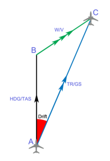
The term “set and drift” is used to describe external forces that affect a boat and keep it from following an intended course. To understand and calculate set and drift, one needs to first understand currents. Ocean currents are the horizontal movements of water from one location to another. The movement of water is impacted by: meteorological effects, wind, temperature differences, gravity, and on occasion earthquakes. Set is referred to as the current's direction, expressed in true degrees. Drift is referred to as the current's speed, which is usually measured in knots. “Leeway” refers to the amount of sidewards translation of a vessel drifting off of or away from the intended course of travel

<span class="mw-page-title-main">Magnetic declination</span> Angle on the horizontal plane between magnetic north and true north

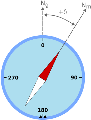
Magnetic declination is the angle between magnetic north and true north at a particular location on the Earth's surface. The angle can change over time due to polar wandering.

<span class="mw-page-title-main">Compass rose</span> Figure on a compass, map, nautical chart

A compass rose, sometimes called a wind rose, rose of the winds or compass star, is a figure on a compass, map, nautical chart, or monument used to display the orientation of the cardinal directions and their intermediate points. It is also the term for the graduated markings found on the traditional magnetic compass. Today, a form of compass rose is found on, or featured in, almost all navigation systems, including nautical charts, non-directional beacons (NDB), VHF omnidirectional range (VOR) systems, global-positioning systems (GPS), and similar equipment.

<span class="mw-page-title-main">Points of the compass</span> Directional divisions marked on a compass

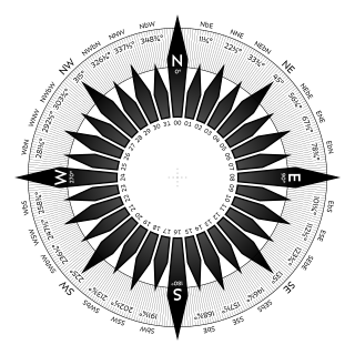
The points of the compass are a set of horizontal, radially arrayed compass directions used in navigation and cartography. A compass rose is primarily composed of four cardinal directions—north, east, south, and west—each separated by 90 degrees, and secondarily divided by four ordinal (intercardinal) directions—northeast, southeast, southwest, and northwest—each located halfway between two cardinal directions. Some disciplines such as meteorology and navigation further divide the compass with additional azimuths. Within European tradition, a fully defined compass has 32 'points'.

Piloting or pilotage is the process of navigating on water or in the air using fixed points of reference on the sea or on land, usually with reference to a nautical chart or aeronautical chart to obtain a fix of the position of the vessel or aircraft with respect to a desired course or location. Horizontal fixes of position from known reference points may be obtained by sight or by radar. Vertical position may be obtained by depth sounder to determine depth of the water body below a vessel or by altimeter to determine an aircraft's altitude, from which its distance above the ground can be deduced. Piloting a vessel is usually practiced close to shore or on inland waterways. Pilotage of an aircraft is practiced under visual meteorological conditions for flight.

<span class="mw-page-title-main">Meridian (geography)</span> Line between the poles with the same longitude

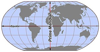
In geography and geodesy, a meridian is the locus connecting points of equal longitude, which is the angle east or west of a given prime meridian. In other words, it is a line of longitude. The position of a point along the meridian is given by that longitude and its latitude, measured in angular degrees north or south of the Equator. On a Mercator projection or on a Gall-Peters projection, each meridian is perpendicular to all circles of latitude. A meridian is half of a great circle on Earth's surface. The length of a meridian on a modern ellipsoid model of Earth has been estimated as 20,003.93 km (12,429.87 mi).

In aviation, aircraft compass turns are turns made in an aircraft using only a magnetic compass for guidance.

<span class="mw-page-title-main">Course (navigation)</span> Cardinal direction for steering

In navigation, the course of a watercraft or aircraft is the cardinal direction in which the craft is to be steered. The course is to be distinguished from the heading, which is the direction where the watercraft's bow or the aircraft's nose is pointed.

<span class="mw-page-title-main">Pelorus (instrument)</span>

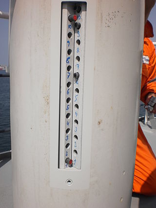
In marine navigation, a pelorus is a reference tool for maintaining bearing of a vessel at sea. It is a "simplified compass" without a directive element, suitably mounted and provided with vanes to permit observation of relative bearings.

<span class="mw-page-title-main">Magnetic deviation</span>

Magnetic deviation is the error induced in a compass by local magnetic fields, which must be allowed for, along with magnetic declination, if accurate bearings are to be calculated.

<span class="mw-page-title-main">Diver navigation</span> Underwater navigation by scuba divers

Diver navigation, termed "underwater navigation" by scuba divers, is a set of techniques—including observing natural features, the use of a compass, and surface observations—that divers use to navigate underwater. Free-divers do not spend enough time underwater for navigation to be important, and surface supplied divers are limited in the distance they can travel by the length of their umbilicals and are usually directed from the surface control point. On those occasions when they need to navigate they can use the same methods used by scuba divers.

<span class="mw-page-title-main">North magnetic pole</span> Earths magnetic pole in the Northern Hemisphere

The north magnetic pole, also known as the magnetic north pole, is a point on the surface of Earth's Northern Hemisphere at which the planet's magnetic field points vertically downward. There is only one location where this occurs, near the geographic north pole. The geomagnetic north pole is the northern antipodal pole of an ideal dipole model of the Earth's magnetic field, which is the most closely fitting model of Earth's actual magnetic field.

<span class="mw-page-title-main">History of geomagnetism</span> History of the study of Earths magnetic field

The history of geomagnetism is concerned with the history of the study of Earth's magnetic field. It encompasses the history of navigation using compasses, studies of the prehistoric magnetic field, and applications to plate tectonics.

<span class="mw-page-title-main">Azimuth compass</span> Nautical instrument

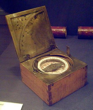
An azimuth compass is a nautical instrument used to measure the magnetic azimuth, the angle of the arc on the horizon between the direction of the Sun or some other celestial object and the magnetic north. This can be compared to the true azimuth obtained by astronomical observation to determine the magnetic declination, the amount by which the reading of a ship's compass must be adjusted to obtain an accurate reading. Azimuth compasses were important in the period before development of the reliable chronometers needed to determine a vessel's exact position from astronomical observations.

Direction determination refers to the ways in which a cardinal direction or compass point can be determined in navigation and wayfinding. The most direct method is using a compass, but indirect methods exist, based on the Sun path, the stars, and satellite navigation.

References

  1. 1 2 Gade, Kenneth (2016). "The Seven Ways to Find Heading" (PDF). Journal of Navigation . Cambridge University Press. 69 (5): 955–70. doi:10.1017/S0373463316000096. S2CID   53587934.

Bibliography