Beaufort Historic District (Beaufort, South Carolina)

Last updated

Beaufort Historic District
Saltus-Habersham House, 802 Bay Street, (Beaufort, South Carolina).jpg
Saltus-Habersham House, 802 Bay Street
USA South Carolina location map.svg
Red pog.svg
Usa edcp location map.svg
Red pog.svg
LocationBounded by the Beaufort River, Bladen, Hamar, and Boundary Sts., Beaufort, South Carolina
Coordinates 32°26′8″N80°40′4″W / 32.43556°N 80.66778°W / 32.43556; -80.66778
Area304 acres (123 ha)
Built1521
Architectural styleFederal, Greek Revival
NRHP reference No. 69000159 [1]
Significant dates
Added to NRHPDecember 17, 1969 [1]
Designated NHLDNovember 7, 1973 [2]

Beaufort Historic District is a historic district in Beaufort, South Carolina. It was listed on the National Register of Historic Places in 1969, [1] and was declared a National Historic Landmark in 1973. [2] [3]

Contents

The historic district is renowned for its impressive collection of antebellum architecture that reflect the Federal, neoclassical, and Greek revival styles that were popular during the interwar period, along with the widespread use of tabby. A variety of homes, gardens, commercial buildings, houses of worship and graveyards are featured in the district, with some sites open for public inspection. Continuous efforts at rehabilitation and conservation underline the community's commitment to maintaining the historic nature of the district, which has attracted much acclaim and garnered popularity from visitors and media outlets.

The district's condition has been assessed several times since it was listed in 1969, and in 1998 the National Park Service proposed listing the district as "threatened" due to an ongoing gradual loss of historic integrity. Partly in reaction to this, the district's significance was broadened to include a distinctive historical element of post-Civil War history. The Port Royal Experiment, centered in Beaufort, involved a large-scale redistribution of land from large landowners to former African-American slaves in an effort to assimilate the freed slaves into a modern post-war society. This Reconstruction-era effort had a marked impact on Beaufort's built environment, and is still evident in the surviving buildings. [3]

Neighborhoods

The district can be further divided into five unique and distinct neighborhoods. For some purposes, the Northwest Quadrant neighborhood is not considered to be in the historic district, however it is often grouped in together with the other neighborhoods.

Downtown is centered along Bay Street, Beaufort's historic commercial street. It includes other nearby streets and is mainly commercial in character. Located between the Beaufort River and Bay Street is the newly renovated Henry Chambers Waterfront Park, which overlooks the Beaufort River and is home to many of the city's festivals and events. Most non-tourist commercial services have since relocated to other areas in the city, leaving mostly restaurants and shops that showcase various art, handicrafts, and antiques.

Homes in the Old Point neighborhood Craven Street Beaufort.JPG
Homes in the Old Point neighborhood

The Point neighborhood (also known as the Old Point) is home to some of Beaufort's largest, oldest, and most expensive homes. Defined as the land between Carteret Street and the Beaufort River, this portion of downtown does not follow the major street grid and was once an area where a timber mill operated. Homes in this area range from the impressive mansions that overlook the Beaufort river to Victorian and Queen Anne style homes along Craven Street. Streetscapes are typically dominated by an impressive live oak canopy, often accompanied by Spanish moss. The Rhett House Inn is at 1009 Craven Street.

The Bluff area is located along Bay Street and North Street, immediately west of downtown. The large homes in the area are some of the most recognizable in the city, and have a scenic overlook of the Beaufort River. The art deco U.S. District Courthouse is located at the western end of the Bluff.

The Old Commons neighborhood (also known as the Northeast Quadrant) is located in the northeastern portion of Beaufort's original street grid, and is defined as the area among Carteret Street on the east, North Street on the south, Charles Street on the west, and Boundary Street to the north. Originally home to a hodgepodge of medium-sized homes, graveyards, and chapels, this section of downtown is undergoing reinvestment and redevelopment, yet retains a southern style of architecture. Nearly all homes in this neighborhood employ front or side porches.

The Northwest Quadrant neighborhood is loosely defined as the area between Charles Street on the east, Prince Street to the south, Ribaut Road on the west, and Boundary Street to the north. This area has for generations been the center of Beaufort's African-American community and is composed of late 19th and early 20th century homes, many in a shotgun architectural style. Bladen Street serves as the principal street through the community, and was recently renovated with improved landscaping and pedestrian access. There have been increased efforts at rehabilitation of several properties in the Quadrant, though significant financial and social obstacles often hinder these efforts.

Historic sites

Several sites individually listed on the National Register are in Beaufort and may be contributing properties in this district. These include:

The William Johnson House and the Parish Church of St. Helena are contributing properties. [4]

See also

Related Research Articles

<span class="mw-page-title-main">Beaufort, North Carolina</span> Town in North Carolina, United States

Beaufort is a town in and the county seat of Carteret County, North Carolina, United States. Established in 1713 and incorporated in 1723, Beaufort is the fourth oldest town in North Carolina . On February 1, 2012, Beaufort was ranked as "America's Coolest Small Town" by readers of Budget Travel Magazine.

<span class="mw-page-title-main">Morehead City, North Carolina</span> Town in North Carolina, United States

Morehead City is a port town in Carteret County, North Carolina, United States. The population was 8,661 at the 2010 census. Morehead City celebrated the 150th anniversary of its founding on May 5, 2007. It forms part of the Crystal Coast.

<span class="mw-page-title-main">Beaufort, South Carolina</span> City in South Carolina, United States

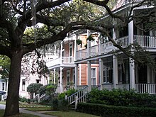
Beaufort is a city in and the county seat of Beaufort County, South Carolina, United States. Chartered in 1711, it is the second-oldest city in South Carolina, behind Charleston, which was established in 1670. A city rich in history, culture, southern hospitality, and a seaside charm, Beaufort is affectionally known as the "Queen of the Carolina Sea Islands". The city's population was 13,607 at the 2020 census. It is part of the Hilton Head Island–Bluffton metropolitan area.

<span class="mw-page-title-main">Bluffton, South Carolina</span> Town in South Carolina, United States

Bluffton is a town in southern Beaufort County, South Carolina, United States. The population as of the 2020 census was 27,716, an increase of over 120% since 2010, making it one of the fastest growing municipalities in South Carolina. Bluffton is the fifth largest municipality in South Carolina by land area. It is primarily located around U.S. Route 278, between Hilton Head Island and Interstate 95. The Lowcountry town's original one square mile area, now known as Old Town, is situated on a bluff along the May River. The town is a primary town within the Hilton Head Island–Bluffton Metropolitan Area.

<span class="mw-page-title-main">University of South Carolina Beaufort</span> Public university in South Carolina

The University of South Carolina Beaufort is a public college with three campuses in the Lowcountry region of South Carolina. It is part of the University of South Carolina System, enrolls about 2,000 students, and offers over 20 programs of study. The main campus is in Bluffton, South Carolina. The institution's campus in Beaufort houses the school's honor programs and the Department of Visual Arts & Design. The campus location on Hilton Head Island is home to the institution's program for hospitality management.

<span class="mw-page-title-main">Daufuskie Island</span> Census-designated place in South Carolina, United States

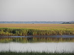
Daufuskie Island, located between Hilton Head Island and Savannah, is the southernmost inhabited sea island in South Carolina. It is 5 miles (8 km) long by almost 2.5 miles (4.0 km) wide – approximate surface area of 8 square miles (21 km2). With over 3 miles (5 km) of beachfront, Daufuskie is surrounded by the waters of Calibogue Sound, the Intracoastal Waterway and the Atlantic Ocean. It was listed as a census-designated place in the 2020 census with a population of 557.

<span class="mw-page-title-main">French Quarter (Charleston, South Carolina)</span> United States historic place

The French Quarter is a historic district and a section of downtown Charleston, South Carolina, United States, that is listed on the National Register of Historic Places.

<span class="mw-page-title-main">Robert Smalls</span> Former slave and American politician (1839–1915)

Robert Smalls was an American politician, publisher, businessman and maritime pilot. Born into slavery in Beaufort, South Carolina, he freed himself, his crew and their families during the American Civil War by commandeering a Confederate transport ship, CSS Planter, in Charleston harbor, on May 13, 1862, and sailing it from the Confederate-controlled waters of the harbor to the U.S. blockade that surrounded it. He then piloted the ship to the Union-controlled enclave in Beaufort–Port Royal–Hilton Head area, where it became a Union warship. His example and persuasion helped convince President Abraham Lincoln to accept African-American soldiers into the Union Army.

<span class="mw-page-title-main">Neighborhoods of Tulsa, Oklahoma</span>

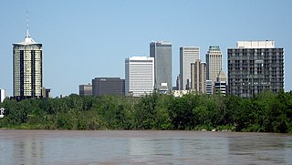
Tulsa is the second-largest city in the state of Oklahoma. It has many diverse neighborhoods due to its size.

<span class="mw-page-title-main">Barnwell-Gough House</span> Historic house in South Carolina, United States

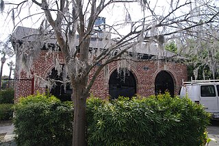
The Barnwell-Gough House, also known as Old Barnwell House, is a house built in Beaufort, South Carolina in 1789.

<span class="mw-page-title-main">Robert Smalls House</span> Historic house in South Carolina, United States

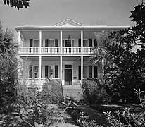
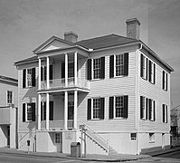
The Robert Smalls House is a historic house at 511 Prince Street in Beaufort, South Carolina. Built in 1843 and altered several times, the house was designated a National Historic Landmark in 1974 for its association with Robert Smalls (1839-1915). Smalls, born into slavery, achieved notice for commandeering the CSS Planter and sailing her to freedom during the American Civil War. After the war he represented South Carolina in the United States House of Representatives during Reconstruction.

Frogmore is an unincorporated community on St. Helena Island in Beaufort County, South Carolina, United States, along U.S. Route 21.

<span class="mw-page-title-main">Tabby Manse</span> Historic house in South Carolina, United States

Tabby Manse, also known as Thomas Fuller House, is a building in Beaufort, South Carolina.

<span class="mw-page-title-main">John Mark Verdier House</span> Historic house in South Carolina, United States

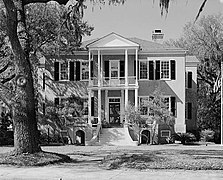
John Mark Verdier House, also known as Lafayette Building, is a building in Beaufort, South Carolina. It was built by John Mark Verdier, a French Huguenot, in 1804. The house typified Beaufort's gracious antebellum architectural style. It was a focal point of the town, a visible statement reflecting Verdier's significant wealth from trading indigo and growing sea island cotton.

<span class="mw-page-title-main">Marshlands (Beaufort, South Carolina)</span> Historic house in South Carolina, United States

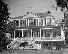
Marshlands, also known as the James Robert Verdier House, is a historic house at 501 Pinckney Street in Beaufort, South Carolina. Built about 1814, it is a high quality and well-preserved example of early Beaufort architecture, showing both Adamesque and West Indian stylistic influences. It is also notable as a home of Dr. James Robert Verdier, who discovered a treatment for yellow fever. It was designated a National Historic Landmark in 1973 for its architectural significance.

Isaac Fripp House Ruins is a historic house ruin and archaeological site located on Saint Helena Island near Frogmore, Beaufort County, South Carolina. The ruins are located at Bay View overlooking the junction of Chowan Creek and the Beaufort River. The two-story, tabby house dates to the early- to mid-19th century. It is associated with Isaac Fripp, a planter of sea island cotton and other staples on St. Helena Island.

Orange Grove Plantation is a historic plantation house and national historic district located on Saint Helena Island near Frogmore, Beaufort County, South Carolina. The district encompasses one contributing building and two contributing sites, and reflects the early-20th century influx of Northerners onto St. Helena Island. The plantation was first recorded in 1753 when Peter Perry purchased 473 acres. Perry owned 46 chattel slaves. The plantation house, built about 1800, was in poor condition when Henry L. Bowles (1866-1932), a U.S. Representative from Massachusetts, bought the property in 1928. He demolished it and built the present house in the same year. The property also includes the tabby ruin of the kitchen, built about 1800, and a tabby-walled cemetery containing three early-19th century graves of the Fripp and Perry families.

<span class="mw-page-title-main">Reconstruction Era National Historical Park</span> National Historical Park of the United States in South Carolina

The Reconstruction Era National Historical Park, formerly Reconstruction Era National Monument is a United States National Historical Park in Beaufort County, South Carolina established by President Barack Obama in January 2017 to preserve and commemorate activities during the Reconstruction Era that followed the American Civil War. The monument was the first U.S. National Monument dedicated to the Reconstruction Era. The John D. Dingell, Jr. Conservation, Management, and Recreation Act, signed March 12, 2019, by President Donald Trump, re-designated it as a national historical park. It is administered by the National Park Service.

<span class="mw-page-title-main">The Cobbler's Cottage</span> United States historic place

The Cobbler's Cottage is a ca-1870 historic cottage in the United States National Historic Landmark District – Beaufort Historic District. The Cobbler's Cottage is a contributing property, # U-13-1013, of the Beaufort Historic District making the cottage a recognized member of the “National Register of Historic Places”. The Cobbler's Cottage is located at Block 66, Lot C, 713 Charles Street, Beaufort, South Carolina.

<span class="mw-page-title-main">Rhett House Inn</span> Historic Inn in South Carolina, U.S.

The Rhett House Inn, is a historic Inn at 1009 Craven Street, Beaufort, South Carolina. It is significant as the home of Thomas Moore Rhett and his wife, Caroline Barnwell, who were early pioneers in South Carolina in the 1800s. The Inn is in the Point neighborhood, which is part of the Beaufort Historic District. Today, the Rhett House Inn serves as a Four Diamond bed and breakfast Inn.

References

  1. 1 2 3 "National Register Information System". National Register of Historic Places . National Park Service. July 9, 2010.
  2. 1 2 "Beaufort Historic District". National Historic Landmark summary listing. National Park Service. Archived from the original on October 23, 2007. Retrieved February 15, 2008.
  3. 1 2 Fant, Mrs. James W. (November 8, 1969). "Historic Beaufort" (PDF). National Register of Historic Places - Nomination and Inventory (includes 1969 nomination and 1998 update). National Park Service . Retrieved April 22, 2015.
  4. "Archived copy". Archived from the original on July 30, 2021. Retrieved February 24, 2021.{{cite web}}: CS1 maint: archived copy as title (link)