Bluffton, South Carolina

Last updated

Bluffton
Bluffton Montage 2012.png
Clockwise from top: May River, Heyward House, a gravel path, Carecore Drive, a post office, Myrtle Island, and The Store
Bluffton, SC Town Flag.gif
Town of Bluffton Seal.png
Bluffton, SC Town Logo.jpg
Nickname: 
Heart Of The Lowcountry
Motto: 
"A State of Mind"
Bluffton, South Carolina
Interactive map of Bluffton
USA South Carolina relief location map.svg
Red pog.svg
Bluffton
Location within South Carolina
Usa edcp relief location map.png
Red pog.svg
Bluffton
Location within the United States
Coordinates: 32°14′14″N80°51′37″W / 32.2371465°N 80.8603868°W / 32.2371465; -80.8603868
CountryUnited States
State South Carolina
Counties Beaufort
Settled1728
Incorporated1852 [1]
Named for Original jurisdiction on a bluff above the May River [2]
Government
  Type Council–manager
  BodyBluffton Town Council
   Mayor Larry Toomer
  Council
Members [3]
  • Emily Burden
  • Bridgette Frazier
  • Fred Hamilton
  • Dan Wood
Area
[4]
  Total54.19 sq mi (140.36 km2)
  Land51.97 sq mi (134.60 km2)
  Water2.23 sq mi (5.77 km2)  4.12%
Elevation
20 ft (6 m)
Population
 (2020) [5]
  Total27,716
  Estimate 
(2022)
34,493
  Density533.33/sq mi (205.92/km2)
   Urban
71,824 (US: 395th) [6]
  Urban density1,135.7/sq mi (438.5/km2)
Time zone UTC-5 (EST)
  Summer (DST) UTC-4 (EDT)
ZIP codes
29909-29910
Area code 843, 854
FIPS code 45-07210
GNIS feature ID1220833
Website www.townofbluffton.sc.gov

Bluffton is a town in southern Beaufort County, South Carolina, United States. The population as of the 2020 census was 27,716, an increase of over 120% since the 2010 census, making it the 17th-most populous municipality and one of the fastest growing municipalities in South Carolina. [7] [8] It is primarily located around U.S. Route 278, between Hilton Head Island and Interstate 95. The Lowcountry town's original one square mile area, now known as Old Town, is situated on a bluff along the May River. Bluffton is a primary town within the Hilton Head Island-Bluffton-Port Royal, SC Metropolitan Statistical Area.

Contents

After the Tariff of 1842, Bluffton became a hotbed of separatist sentiment, which in turn led to a protest against federal taxes called the Bluffton Movement in 1844. Even though the movement quickly died out, it somewhat contributed to the secession movement that led to South Carolina being the first state to leave the Union. In the Antebellum Period, Bluffton became a popular location for wealthy merchants and plantation owners. During the Civil War, two thirds of the town was destroyed by fire during the Union's Bluffton Expedition on June 4, 1863. [9]

History

Colonial era (1670–1776)

During the 17th and the 18th centuries, the area comprising southern Beaufort County was known as Granville County of St. Luke's Parish. The Yamasee people were invited to settle in the area by Lord Cardoss, leader of the nearby Scottish settlement in Beaufort. The Yamasee established ten towns with over 1,200 inhabitants in the area. In 1715, the Yamasee War broke out, and after several years of fighting, the Yamasee migrated to Florida, opening the "Indian Lands" to European settlement. In 1718, the Lords Proprietors carved the area into several new baronies, including the Devil's Elbow Barony that contained the future town of Bluffton. The first titled owner of the land was the Barbadian planter Sir John Colleton. Following the departure of the Yamasee people, colonists began building plantations in the Bluffton area in 1728. The Colletons prospered by growing cotton, corn and indigo. [10]

American Revolution (1776–1785)

Before his death in 1776, Sir John Colleton (grandson of the original owner) developed plantations near Victoria Bluff - Foot Point areas and later disposed of much of his barony, much of it bought by the Rose and Kirk families. [10] These plantations were destroyed by the British under General Prévost in 1779. [11] During the 18th century, much of the land south of the May River (now known as Palmetto Bluff) was covered with rice fields. [12] Rice became a lucrative crop and a part of lowcountry culture until the early 20th century when it was disrupted by a series of devastating storms. [13]

Antebellum era (1785–1861)

Church of the Cross ChurchOfTheCross.JPG
Church of the Cross
This 350- to 400-year-old live oak tree at Stock Farm in Bluffton, known as the "Secession Oak", is where in 1844 US Representative Robert Barnwell Rhett of South Carolina called for the South to withdraw from the Union. SecessionOak.jpg
This 350- to 400-year-old live oak tree at Stock Farm in Bluffton, known as the "Secession Oak", is where in 1844 US Representative Robert Barnwell Rhett of South Carolina called for the South to withdraw from the Union.

The town of Bluffton was eventually built on two adjoining parcels in the Devil's Elbow Barony purchased by Benjamin Walls and James Kirk. The first homes were constructed during the early 1800s by area plantation owners seeking the high ground and cool river breezes as an escape from the unhealthy conditions present on Lowcountry rice and cotton plantations. Easy access by water provided more incentive for expansion, and the many tidal coves afforded excellent locations for residences. The community was originally known as "Kirk's Landing" or "Kirk's Bluff" as shown in Mill's Atlas of 1825. The first streets were formally laid out during the 1830s and the name of Bluffton decided upon in the early 1840s as a compromise between the Kirk and Pope families.

The first South Carolina secession movement began under what is now known as the Secession Oak tree, led by Robert Barnwell Rhett on July 31, 1844. In the 1850s, a steamboat landing was built at the end of Calhoun Street, and Bluffton became the commercial center of southern Beaufort County as a stopover for travelers between Savannah and Beaufort. In 1852, the town was officially incorporated by an act of the South Carolina General Assembly and comprised approximately one square mile. [1] The iconic Church of the Cross was designed by architect Edward Brickell White to seat up to 600 parishioners at a cost of $5,000, and construction began in 1854. On July 17, 1857, the first services were held at the Church of the Cross. [15]

Civil War (1861–1865)

After a Union victory at the Battle of Port Royal on November 7, 1861, Confederate Brigadier-General Thomas F. Drayton directed the evacuation of rebel forces from Hilton Head Island to the Bluffton mainland. Occupying Port Royal Harbor, the Union's South Atlantic Blockading Squadron could then be monitored from rebel lookouts dispersed from Bluffton's substantial picket headquarters. Bluffton's location resulted in it being the only strategic position on the East Coast at which the Confederates could gather direct intelligence on the Union squadron that was conducting crucial blockade operations along the southern coastline. In late May 1863, Major-General David Hunter, Commander of the Department of the South, ordered the destruction of Bluffton by fire. The Union "Expedition against Bluffton" was carried out on June 4, 1863, destroying approximately two thirds of the town's estimated 60 structures. [9] Only the town's two churches and fifteen residences remained standing after the attack. Eight antebellum homes and two churches still exist in Old Town and highlight the town's nationally popular registered historic district.

Postbellum era (1865–1945)

Child labor at Varn & Platt Canning Company in Bluffton, 1913. Photo by Lewis Hine 10 year old Jimmie. Been shucking 3 years. 6 pots a day, and a 11 year old boy who shucks 7 pots.jpg
Child labor at Varn & Platt Canning Company in Bluffton, 1913. Photo by Lewis Hine

Rebuilding came slowly, as few local landowners could still afford the luxury of a summer home in Bluffton. The town did not experience a true rebuilding until the 1880s, when it emerged as a commercial center for Beaufort County.

Contemporary era (1945–present)

Palmetto Bluff at Montage Resort in Bluffton Palmetto Bluff.jpg
Palmetto Bluff at Montage Resort in Bluffton

Bluffton remained a commercial center until Coastal Highway (US 17) and the bridge at Port Wentworth over the Savannah River were completed, which made riverboat trade and travel less attractive. The Great Depression began shortly thereafter and brought the closure of the town's prosperity and commercial importance. The popularity of Bluffton as a vacation spot remained even after its loss of commercial stature. The development of Hilton Head Island, nearby Sun City and the related development in the 1990s caused a resurgence of commercial activity in the town. In 1996, Bluffton was designated a National Historic District with 46 contributing buildings and two contributing sites. In 1998, the Heyward House opened to the public by the Bluffton Historical Preservation Society. In 1999, the Heyward House was part of the Save America's Treasures program. The Heyward House became the town's welcome center in 2000, and the Old Town Bluffton historic district was established through zoning regulations and architectural standards. In 2005, Bluffton was recognized as a Preserve America Community, a federal program that encourages community efforts to preserve the nation's cultural and historical assets.

Altamaha Town, Bluffton Historic District, Church of the Cross, and Rose Hill Plantation House are listed on the National Register of Historic Places. [16]

Geography

Map of Bluffton in Beafort County BlufftonImageMap.svg
Map of Bluffton in Beafort County

Bluffton was once mostly wetlands, many of which were drained possibly during the antebellum era. Agriculture and pine timber harvesting contributed to the landscape still present today. The town proper consists of five primary areas. The historic district of Old Town, on the northern bluff of the May River; Palmetto Bluff, located on the southern side of the May River; Jones Estate, situated along the New River; Buckwalter, located on the northwest side of town; and Shultz Tract, north of Old Town. The May River winds through the center of town. The New River forms the southwest boundary of the town.

Topography

According to the United States Census Bureau, the town has a total area of 54.19 square miles (140.4 km2), of which 51.97 square miles (134.6 km2) is land and 2.23 square miles (5.8 km2) (4.12%) is water. [4] Bluffton is the fifth largest municipality in South Carolina by land area. [17] The municipal boundary contains many large "doughnut holes" of unincorporated territory due to South Carolina's strict annexation laws. Most of Bluffton was undeveloped land until the housing boom of the early 2000s, which led to explosive growth in Bluffton's area. Many of Bluffton's planned unit developments were built during this time. As of 2012 many of these developments remain only partially complete due to the economic downturn.

Climate

Bluffton has a humid subtropical climate (Köppen Cfa), with very mild winters, hot, humid summers, and significant rainfall all year long. August is the wettest month; almost half of the annual rainfall occurs during the summer months in the form of thundershowers. Fall remains relatively warm through November. Winter is short and mild, and is characterized by occasional rain. Snow flurries rarely occur. The highest temperature recorded was 107  °F (42  °C ), in 1986, and the lowest temperature recorded was 4 °F (−16 °C) on January 21, 1985. [18] Hurricanes are a major threat to the area during the summer and early fall but there has not been a major hurricane event in Bluffton since the Category 3 Sea Islands Hurricane in 1893.

Climate data for Bluffton, South Carolina
MonthJanFebMarAprMayJunJulAugSepOctNovDecYear
Record high °F (°C)85
(29)
84
(29)
90
(32)
95
(35)
99
(37)
101
(38)
107
(42)
103
(39)
98
(37)
97
(36)
88
(31)
83
(28)
107
(42)
Mean daily maximum °F (°C)60
(16)
63
(17)
70
(21)
75
(24)
82
(28)
86
(30)
90
(32)
88
(31)
84
(29)
78
(26)
70
(21)
64
(18)
76
(24)
Mean daily minimum °F (°C)40
(4)
43
(6)
49
(9)
55
(13)
63
(17)
71
(22)
74
(23)
73
(23)
69
(21)
59
(15)
50
(10)
43
(6)
57
(14)
Record low °F (°C)4
(−16)
15
(−9)
21
(−6)
32
(0)
37
(3)
45
(7)
50
(10)
53
(12)
46
(8)
32
(0)
23
(−5)
10
(−12)
4
(−16)
Average precipitation inches (mm)3.97
(101)
3.31
(84)
3.43
(87)
3.15
(80)
1.97
(50)
4.50
(114)
6.31
(160)
7.63
(194)
5.82
(148)
4.61
(117)
2.59
(66)
3.11
(79)
50.4
(1,280)
Source: The Weather Channel [19]

Demographics

Historical population
CensusPop.Note
1880 170
1910 577
1920 480−16.8%
1930 57018.8%
1940 459−19.5%
1950 4743.3%
1960 356−24.9%
1970 52948.6%
1980 5412.3%
1990 73836.4%
2000 1,27572.8%
2010 12,530882.7%
2020 27,716121.2%
2022 (est.)34,493 [7] 24.5%
U.S. Decennial Census [20] [5]

2020 census

Bluffton racial composition [21]
RaceNum.Perc.
White (non-Hispanic)19,57370.62%
Black or African American (non-Hispanic)2,2848.24%
Native American 610.22%
Asian 5712.06%
Pacific Islander 100.04%
Other/Mixed 1,1694.22%
Hispanic or Latino 4,04814.61%

As of the 2020 census, there were 27,716 people, 7,560 households, and 5,402 families residing in the town.

2010 census

At the 2010 census, [22] there were 12,530 people, 4,417 households, and 3,323 families residing in the town, on a land area of 51.3 square miles (133 km2). The population density was 244.2 inhabitants per square mile (94.3/km2). There were 5,393 housing units at an average density of 105.1 per square mile (40.6/km2).

The town of Bluffton grew 882.7% between the 2000 and 2010 census, making it the fastest growing municipality in South Carolina with a population over 2,500. Housing units grew 976.4%.

The racial makeup of the town was 71.4% White, 16.1% African American, 0.3% Native American, 2.0% Asian, <0.1% Pacific Islander, 7.3% from other races, and 2.9% from two or more races. Hispanic or Latino of any race were 18.8% of the population.

There were 4,417 households, out of which 54.0% had children under the age of 18 living with them, 61.9% were married couples living together, 13.3% had a female householder with no husband present, and 26.4% were non-families. 18.4% of all households were made up of individuals, and 4.1% had someone living alone who was 65 years of age or older. The average household size was 2.84 and the average family size was 3.20.

In the town, the population was spread out, with 28.9% under the age of 18, 6.8% from 18 to 24, 35.5% from 25 to 44, 21.5% from 45 to 64, and 7.3% who were 65 years of age or older. The median age was 32.7 years. For every 100 females, there were 95.5 males. For every 100 females age 18 and over, there were 93.4 males. Estimated household income for 2009 was $53,386, the estimated median house value was $237,868, median gross rent was $1,179. [23]

Bluffton is a principal city in the Hilton Head Island-Bluffton-Port Royal, SC Metropolitan Statistical Area, which includes Beaufort and Jasper counties. In 2014, the MSA had an estimated year-round population of 203,022. [24]

Economy

Long a stopover between Hilton Head and Savannah, Bluffton has become a tourist destination in its own right with a large number of hotels, restaurants and shopping areas such as Tanger Outlets. The Inn at Palmetto Bluff has received a number of awards including Best Hotel in the Country by U.S. News & World Report [25] and Condé Nast Traveler Gold List World's Best Places to Stay, January 2011. [26] Higher education is an important sector in the local economy, with institutions such as the University of South Carolina Beaufort Hilton Head Gateway Campus and Technical College of the Lowcountry nearby. An eclectic art destination, Bluffton has several art galleries located along Calhoun Street. [27] Bluffton is home to South Carolina's last full-time oyster shucking business, Bluffton Oyster Co, which first opened in 1899 at the end of Wharf Street on the banks of the May River. [28]

Arts and culture

Society of Bluffton Artists

The Society of Bluffton Artists is a nonprofit organization established in 1999. [29]

May River Theatre

The May River Theatre is a theatre company that has performances at the Ulmer Auditorium in downtown Bluffton. [30]

Annual events

May River Cleanup MayRiverCleanup.JPG
May River Cleanup
Christmas Parade SavannahPirates.jpg
Christmas Parade

Museums, historical sites and other attractions

Historic buildings, art and historical museums include:

Parks and recreation

Bluffton has many parks and recreational activities. For cycling, Bluffton Parkway and Buckwalter Parkway have bicycle paths on both sides of the road and Bluffton Rd has a bicycle lane from US-278 until the intersection with May River Rd. The following links will display the location of the park in an external web mapping application. [38] [39] [40]

Calhoun St Boat Dock CalhounStDock.jpg
Calhoun St Boat Dock

Boat landings

Government

Bluffton has a Council–manager form of government. The Bluffton Town Council is responsible for the legislative function of the municipality such as establishing policy, passing local ordinances, voting appropriations, and developing an overall vision. The town has a mayor and mayor pro tem position. The Council has four at-large members who serve overlapping four-year terms. Town elections take place every two years in the fall. [45]

Education

Bluffton is served by the Beaufort County School District. The local public schools include:

There are also a number of independent schools, including Cross Schools (K-8), May River Montessori (K-5), Christian Heritage Montessori (K-5), and Saint Gregory the Great Catholic School (K-8). Public institutions of higher education in Bluffton include the University of South Carolina Beaufort South Campus and the Technical College of the Lowcountry.

Bluffton has a public library, a branch of the Beaufort County Library. [46]

Infrastructure

Utilities

Water and sewer service is provided by Beaufort-Jasper Water and Sewer Authority (BJWSA). South Carolina Electric and Gas Company (SCE&G) and Palmetto Electric Cooperative are the major suppliers of power to the town. Hargray provides telephone and broadband services. Waste Management, Inc provides solid waste services.

Transportation

May River Road MayRiverRoad.jpg
May River Road

Airport

Bluffton is served by the Savannah/Hilton Head International Airport, which is located in Savannah, Georgia, and the Hilton Head Island Airport.

Interstates and highways

Interstate 95 runs to the west of Bluffton and is connected to it by U.S. Route 278. Bluffton Parkway, currently under construction, is planned to run from the Hilton Head Island bridge to I-95 near Hardeeville when all phases are complete. As of August 2012, the parkway runs from SC-170 in the west almost to the bridge in the east. Two sections are currently separated by Buckwalter Parkway but are scheduled to be joined by Phase 5B. [47] Local public transportation and dial-a-ride service is provided by Palmetto Breeze, a regional transportation authority run by the Lowcountry Council of Governments, which serves as the regional Metropolitan Planning Organization (MPO). [48] [49]

Major highways

Fire department

The Bluffton Township Fire District was created in 1978, and is comprised all of the land in Beaufort County south of the Broad River except Jenkins Island, Hilton Head Island and Daufuskie Island. In 1994, Jenkins Island was added. [50]

There are nine fire stations in the Bluffton Township Fire District. [51]

Bluffton Township Fire District works with Hilton Head Island Fire & Rescue as a sponsoring agency for two of South Carolina's designated special teams: one of the state's Hazardous Materials/Weapons of Mass Destruction Response Teams and one of the four Regional Urban Search and Rescue Response Teams. [52] [53] [54] [55]

Police

The Town of Bluffton Police Department received national accreditation in 2009. [56] There is one police headquarters, providing operations, support, and neighborhood services. [56]

Notable people

See also

Related Research Articles

<span class="mw-page-title-main">Beaufort County, South Carolina</span> County in South Carolina, United States

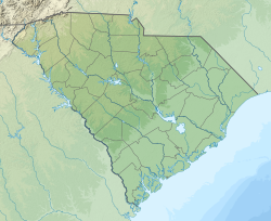
Beaufort County is a county in the U.S. state of South Carolina. As of the 2020 census, its population was 187,117. Its county seat is Beaufort and its largest community is Hilton Head Island.

<span class="mw-page-title-main">Beaufort, South Carolina</span> City in South Carolina, United States

Beaufort is a city in and the county seat of Beaufort County, South Carolina, United States. Chartered in 1711, it is the second-oldest city in South Carolina, behind Charleston. Beaufort is known as the "Queen of the Carolina Sea Islands". The city's population was 13,607 at the 2020 census. It is part of the Hilton Head Island–Bluffton metropolitan area.

<span class="mw-page-title-main">Hilton Head Island, South Carolina</span> Town in South Carolina, United States

Hilton Head Island, often referred to as simply Hilton Head, is a Lowcountry resort town and barrier island in Beaufort County, South Carolina, United States. It is 20 miles (32 km) northeast of Savannah, Georgia, and 95 miles (153 km) southwest of Charleston. The island is named after Captain William Hilton, who in 1663 identified a headland near the entrance to Port Royal Sound, which mapmakers named "Hilton's Headland." The island features 12 miles (19 km) of beachfront on the Atlantic Ocean and is a popular vacation destination. In 2004, an estimated 2.25 million visitors infused more than $1.5 billion into the local economy. The year-round population was 37,661 at the 2020 census, although during the peak of summer vacation season the population can swell to 150,000. Hilton Head Island is the largest city within the Hilton Head Island-Bluffton-Port Royal, SC Metropolitan Statistical Area, which had an estimated population of 232,523 in 2023.

<span class="mw-page-title-main">Port Royal, South Carolina</span> Town in South Carolina, United States

Port Royal is a town on Port Royal Island in Beaufort County, South Carolina, United States. The population was 14,220 at the 2020 census. It is part of the Hilton Head Island–Bluffton metropolitan area. Port Royal is home to Marine Corps Recruit Depot Parris Island and United States Naval Hospital Beaufort.

<span class="mw-page-title-main">Hardeeville, South Carolina</span> City in South Carolina, United States

Hardeeville is a city in Jasper and Beaufort counties in the U.S. state of South Carolina. The population was 7,473 as of the 2020 census, an increase of over 150% since 2010. Hardeeville is included within the Hilton Head Island–Bluffton metropolitan area.

<span class="mw-page-title-main">Yemassee, South Carolina</span> Town in South Carolina, United States

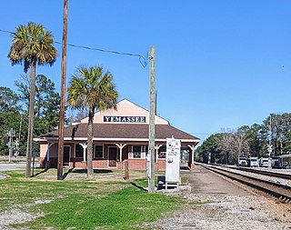
Yemassee is a small Lowcountry town in Beaufort and Hampton counties in the U.S. state of South Carolina. The population was 1,027 at the 2010 census. Yemassee is near the borders of Colleton and Jasper counties. The town is divided by the county line between Beaufort and Hampton counties, which follows the roadbed of the CSX railroad. Most of the town's population presently lies within Hampton County. As defined by the U.S. Census Bureau, the Beaufort County portion of Yemassee is included within the Hilton Head Island-Bluffton-Beaufort, SC Metropolitan Statistical Area. Yemassee hosts one of the few commercial breeding facilities of non-human primates in the entire United States, Alpha Genesis, Inc., which serves as a major employer for the town. Also, the Frank Lloyd Wright-designed Auldbrass Plantation house and outbuildings lie just outside the town limits of Yemassee.

<span class="mw-page-title-main">University of South Carolina Beaufort</span> Public university with three locations in South Carolina, U.S.

The University of South Carolina Beaufort is a public college with three campuses in the Lowcountry region of South Carolina. It is part of the University of South Carolina System, enrolls about 2,000 students, and offers over 50 areas of study. The main campus is in Bluffton, South Carolina. The institution's campus in Beaufort houses the school's honor programs and the Department of Visual Arts & Design. The campus location on Hilton Head Island is home to the institution's program for hospitality management.

<span class="mw-page-title-main">Saint Helena Island (South Carolina)</span> Island in South Carolina, United States

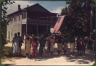
St. Helena Island is a Sea Island in Beaufort County, South Carolina, United States. The island is connected to Beaufort by U.S. Highway 21. The island has a land area of about 64 sq mi (170 km2) and a population of 8,763 as of the 2010 census. It is included as part of the Hilton Head Island-Beaufort Micropolitan Area. The island is renowned for its rural Lowcountry character and being a major center of African-American Gullah culture and language. It is considered to be the geographic influence behind the children's television program Gullah Gullah Island.

<span class="mw-page-title-main">Daufuskie Island</span> Census-designated place in South Carolina, United States

Daufuskie Island, located between Hilton Head Island and Savannah, is the southernmost inhabited sea island in South Carolina. It is 5 miles (8 km) long by almost 2.5 miles (4.0 km) wide – approximate surface area of 8 square miles (21 km2). With over 3 miles (5 km) of beachfront, Daufuskie is surrounded by the waters of Calibogue Sound, the Intracoastal Waterway and the Atlantic Ocean. It was listed as a census-designated place in the 2020 census with a population of 557.

<span class="mw-page-title-main">South Carolina Lowcountry</span> Geographic and cultural region located along South Carolinas coast

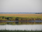
The Lowcountry is a geographic and cultural region along South Carolina's coast, including the Sea Islands. The region includes significant salt marshes and other coastal waterways, making it an important source of biodiversity in South Carolina.

<span class="mw-page-title-main">U.S. Route 278 in South Carolina</span> U.S. highway in South Carolina

U.S. Route 278 (US 278) is a 146.130-mile (235.173 km) east–west United States highway that traverses through the South Carolina Lowcountry, from North Augusta to Hilton Head Island.

<span class="mw-page-title-main">South Carolina Highway 170</span> State highway in South Carolina

South Carolina Highway 170 (SC 170) is a 49.010-mile (78.874 km) state highway, connecting northern Beaufort County with southern portions of Beaufort and Jasper counties. Due to increased population growth in both areas, the majority of the road is four lanes wide, with certain areas retaining the original two-lane configuration.

Hargray Communications is a telecommunications provider based on Hilton Head Island, South Carolina, United States. It operates internet throughout the Lowcountry region of South Carolina and the Savannah region of Georgia. Hargray has a monopoly on parts of the Lowcountry offering cable television, broadband Internet, and landline services. Hargray formerly resold cellular phone service through Cricket.

<span class="mw-page-title-main">South Carolina Highway 46</span> State highway in South Carolina

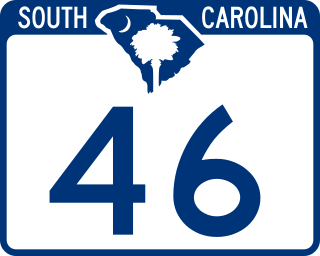
South Carolina Highway 46 (SC 46) is a 17.330-mile-long (27.890 km) state highway in Jasper and Beaufort counties in the Lowcountry region of South Carolina. It connects the rapidly growing communities of Hardeeville and Bluffton and serves as a parallel route to U.S. Route 278 (US 278).

<span class="mw-page-title-main">Church of the Cross</span> Historic church in South Carolina, United States

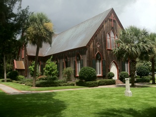
The Church of the Cross is a historic church on Calhoun Street in Bluffton, South Carolina.

<span class="mw-page-title-main">Sun City Hilton Head</span> Unincorporated community in South Carolina, United States

Del Webb's Sun City Hilton Head is an age-restricted planned community located in the Okatie area of Beaufort and Jasper counties in the Lowcountry region of South Carolina. Although not a separate incorporated community or census-designated place, there are close to 10,000 permanent residents within three major phases of the community, which is clustered around its golf courses and community centers. The community is also renowned for its political activism, with many local, state, and national candidates for political office stopping in Sun City while in the area. Sun City is included within the Hilton Head Island-Bluffton-Beaufort, SC Metropolitan Statistical Area.

Okatie is an unincorporated suburban community west of Hilton Head Island, located in Beaufort and Jasper counties, in the Lowcountry of South Carolina. Okatie takes its name from the nearby Okatee River, an estuary of the Port Royal Sound. The headquarters of the Beaufort-Jasper Water and Sewer Authority are located in Okatie, as are the Beaufort-Jasper Academy for Career Excellence and John Paul II Catholic High School.

<span class="mw-page-title-main">Hilton Head Island–Bluffton metropolitan area</span> Metropolitan Statistical Area in South Carolina, United States

The Hilton Head Island metropolitan area, officially the Hilton Head Island–Bluffton–Port Royal, SC Metropolitan Statistical Area as defined by the United States Census Bureau, is a metropolitan statistical area consisting of the two southernmost counties in the Lowcountry region of South Carolina, centered on the resort town of Hilton Head Island. As of the 2020 census, the MSA had a population of 215,908. Prior to March 2013, the region was considered a micropolitan statistical area.

<span class="mw-page-title-main">Callawassie Island</span> Island in South Carolina, United States

Callawassie Island is one of hundreds of barrier and sea islands in the southeast corner in the outer coastal plain, making up a portion of Beaufort County, South Carolina.

<span class="mw-page-title-main">Campbell Chapel African Methodist Episcopal Church (Bluffton, South Carolina)</span> Historic church in South Carolina, United States

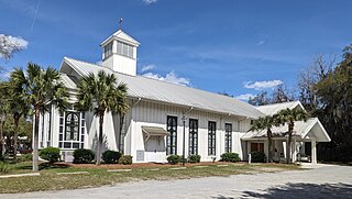
Campbell Chapel African Methodist Episcopal Church is a historic church and congregation in Bluffton, South Carolina.

References

  1. 1 2 "Bluffton, South Carolina". South Carolina Encyclopedia . Retrieved July 25, 2022.
  2. "About Bluffton". www.townofbluffton.sc.gov. Retrieved December 7, 2022.
  3. "Mayor & Town Council". www.townofbluffton.sc.gov. Retrieved March 29, 2024.
  4. 1 2 "ArcGIS REST Services Directory". United States Census Bureau. Retrieved October 15, 2022.
  5. 1 2 "Census Population API". United States Census Bureau. Retrieved October 15, 2022.
  6. United States Census Bureau (December 29, 2022). "2020 Census Qualifying Urban Areas and Final Criteria Clarifications". Federal Register.
  7. 1 2 "QuickFacts: Bluffton town, South Carolina". United States Census Bureau. Retrieved September 14, 2022.
  8. "Census 2010: South Carolina" USA Today, March 23, 2011. Accessed June 6, 2012.
  9. 1 2 Jeff Fulgham, The Bluffton Expedition: The Burning of Bluffton, South Carolina, During the Civil War (Bluffton, S.C.: Jeff Fulgham, 2012), 155.
  10. 1 2 Rose Hill Mansion rosehillmansion.com [ dead link ]
  11. Huffman, Donna (2007). A Guide to Historic Bluffton. Bluffton Historical Preservation Society. p. 8. ISBN   978-1-60530-375-8.
  12. Martin, Grant (July 4, 2012). "Palmetto Bluff to re-create history with 40 acres of rice fields". Island Packet. Archived from the original on September 14, 2012.
  13. Island Packet article storm islandpacket.com
  14. Wile, Rob (July 31, 2010). "Secession Oak Draws Crowd on 166th Anniversary of Bluffton Speech Under its Bows". The Island Packet. Archived from the original on March 19, 2014.
  15. Historic District Inventory townofbluffton.sc.gov [ permanent dead link ]
  16. "National Register Information System". National Register of Historic Places . National Park Service. July 9, 2010.
  17. "Southeastdiscovery" Southeast Discovery, Accessed June 12, 2012.
  18. Maximum and minimum temperatures from Weather.com
  19. "Average Weather for Bluffton, SC – Temperature and Precipitation" . Retrieved June 6, 2012.
  20. "Census of Population and Housing". Census.gov. Retrieved June 4, 2015.
  21. "Explore Census Data". data.census.gov. Retrieved December 15, 2021.
  22. "U.S. Census website". United States Census Bureau . Retrieved January 31, 2008.
  23. "Bluffton, South Carolina City-Data" City-data.com. Retrieved August 28, 2012.
  24. List of Primary Statistical Areas
  25. "Inn at Palmetto Bluff, Bluffton Among the best hotels in the world". Islandpacket.com. July 6, 2012. Archived from the original on April 7, 2014. Retrieved August 28, 2012.
  26. "Inn at Palmetto Bluff, Bluffton in the Condé Nast Traveler Gold List on". Concierge.com. Archived from the original on March 9, 2012. Retrieved April 6, 2011.
  27. "Bluffton art walk set to kickoff Friday". Islandpacket.com. April 10, 2011. Archived from the original on April 7, 2014. Retrieved August 28, 2012.
  28. "Bluffton Oyster Co. wins state, regional small business award". Islandpacket.com. April 26, 2011. Archived from the original on April 7, 2014. Retrieved August 28, 2012.
  29. " Archived February 2, 2015, at the Wayback Machine THE SOCIETY OF BLUFFTON ARTISTS (SoBA), Accessed August 29, 2012.
  30. "The May River Theatre" . Retrieved December 16, 2016.
  31. Bluffton Village Festival History , Accessed September 4, 2012.[ dead link ]
  32. "2022 Town of Bluffton Christmas Parade | Bluffton, SC". www.townofbluffton.sc.gov. Retrieved November 6, 2022.
  33. Arts & Seafood Festival, Accessed September 4, 2012.
  34. "4th Annual SHAG & DRAG". Hilton Head, SC | HiltonHead.com. Retrieved November 6, 2022.
  35. "May River Cleanup". American Rivers. Retrieved November 6, 2022.
  36. "Historic Campbell Chapel AME Church". South Carolina Lowcountry. March 9, 2021. Retrieved August 12, 2021.
  37. Wilson, Lisa (September 1, 2019). "Freed slaves spent $500 to buy a church in Bluffton 145 years ago. It's still standing". The Island Packet. McClatchy . Retrieved August 12, 2021.
  38. "wildlife outdoors and enjoy exceptional hiking and biking opportunities at ar". Bluffton.com. January 2, 2018. Retrieved November 6, 2022.
  39. GmbH, Bikemap. "Cycling routes in Bluffton". Bikemap. Retrieved November 6, 2022.
  40. "Parks | Bluffton, SC". www.townofbluffton.sc.gov. Retrieved November 6, 2022.
  41. "Oyster Factory Park". Bluffton, SC. Retrieved November 6, 2022.
  42. "H.E. Trask Boat Landing to Close: Repair Project Scheduled to Begin Monday, July 11". www.beaufortcountysc.gov. Retrieved November 6, 2022.
  43. Star, Rock (February 8, 2021). "Wright Family Park and Calhoun Street Dock | Waterfront Park | Bluffton". Bluffton SC. Retrieved November 6, 2022.
  44. "Boat Landings:Alljoy Boat Landing: 265 Alljoy Rd., Bluffton Acces". Bluffton.com. July 3, 2019. Retrieved November 6, 2022.
  45. "Town of Bluffton Website - Governing Section" Archived July 30, 2012, at the Wayback Machine Town of Bluffton. Retrieved June 6, 2012.
  46. "South Carolina libraries and archives". SCIWAY. Retrieved June 7, 2019.
  47. "Employment Fast Facts," Archived May 1, 2012, at the Wayback Machine Bluffton Parkway extension to open for drivers Monday - Accessed August 29, 2012.
  48. "About Us". www.palmettobreezetransit.com. Retrieved August 10, 2023.
  49. "Transportation". www.lowcountrycog.org. Retrieved August 10, 2023.
  50. "About BTFD" Archived September 23, 2012, at the Wayback Machine BTFD About - Accessed August 28, 2012.
  51. "Bluffton Township South Carolina Fire District Home Page". Bluffton Township South Carolina Fire District. Retrieved November 6, 2022.
  52. "Regional US&R Teams," South Carolina Firefighter Mobilization Oversight Committee, Accessed May 20, 2007.
  53. "Safety First - The Hilton Head/Bluffton Disaster Response Team Trains for Emergency Rescue Missions," Archived July 18, 2011, at the Wayback Machine The Bluffton Today, January 10, 2008. Accessed January 12, 2008.
  54. "Firefighters in SC train in tornado scenario," [ permanent dead link ]Fire Engineering, January 9, 2008. Accessed January 12, 2008.
  55. "Mock tornado stirs up read training locally," Archived January 10, 2008, at the Wayback Machine The Island Packet, January 9, 2008. Accessed January 12, 2008.
  56. 1 2 "Bluffton Police 2011 Annual Report;– relocation, real estate, travel, jobs, hospitals, schools, crime, move, moving, houses news, sex offenders" (PDF). blufftonpolice.com. Retrieved August 28, 2012.

Works cited