Darlington, South Carolina

Last updated

Darlington, South Carolina
Courthouse Darlington County, SC, US.jpg
Darlington County Courthouse
Darlington, SC City Seal.webp
SCMap-doton-Darlington.PNG
Location of Darlington, South Carolina
Coordinates: 34°18′5″N79°52′7″W / 34.30139°N 79.86861°W / 34.30139; -79.86861
Country Flag of the United States.svg United States
State Flag of South Carolina.svg South Carolina
County Darlington
Founded1835
Government
  TypeCity Manager-Council
  MayorJessica Souderton
Area
[1]
  Total4.71 sq mi (12.20 km2)
  Land4.71 sq mi (12.20 km2)
  Water0.00 sq mi (0.00 km2)
Elevation
148 ft (45 m)
Population
 (2020) [2]
  Total6,149
  Density1,304.97/sq mi (503.85/km2)
Time zone UTC−5 (Eastern (EST))
  Summer (DST) UTC−4 (EDT)
ZIP codes
29532, 29540
Area code(s) 843/854
FIPS code 45-18565 [3]
GNIS feature ID1247486 [4]
Website cityofdarlington.com

Darlington is a city located in Darlington County, South Carolina, United States. [5] In 2010, its population was 6,289. [6] It is the county seat of Darlington County. It is part of the Florence, South Carolina Metropolitan Statistical Area.

Contents

Darlington is known for its Darlington Oak and Spanish moss. [7] Darlington is home to the famous Darlington Raceway, which hosts the annual NASCAR Southern 500 race on Labor Day weekend as well as a 400-mile spring race. It is also the site of the National Motorsports Press Association (NMPA) Hall of Fame. Darlington is also a center for tobacco farming.

Darlington is located 10 miles (16 km) northwest of Florence and 76 miles (122 km) northeast of the state capital, Columbia.

History

Early history

Darlington's origins date back to the mid-18th century.

Originally a heavily wooded area, the settlement of what is now Darlington County began in earnest after 1736 and 1737 when the province of South Carolina set aside a vast area of land for the Welsh Baptists of Delaware. This Welsh Tract bordered both sides of the Pee Dee River. For almost thirty years, settlers concentrated on the banks and small tributaries of the Pee Dee River. Beginning in the 1760s, and continuing into the 1770s, other groups slowly made their way into present-day Darlington, and were granted lands on the Lynches River, Jeffries Creek, and a host of other watercourses. These settlers included descendants of French Huguenots, Scots-Irish, and the English.

For 30 years following the arrival of the first settlers, local government did not exist for the citizens of the area. All deeds, estate settlements, and other legal matters had to be taken to Charles Town to be recorded. In 1769, by an Act of the Assembly, Cheraw District was established as a Judicial District. A courthouse and jail were built at Long Bluff (near present-day Society Hill), and were operational by late 1772.

After the Revolutionary War, in 1785, Cheraw District was divided into three counties, Marlborough, Chesterfield, and Darlington. Darlington County was bounded by the Pee Dee River), Lynches River, and Cedar Creek. To this day it is unknown why the county was named "Darlington", although it could be named after the town of the same name in County Durham, England. After 1798 the designation "county" was changed to "district". In 1835, the city of Darlington became the new county seat. In the 1868 South Carolina Constitution, the designation reverted to "county".

Florence County was created out of parts of Darlington and Marion counties in 1888. Darlington County gave up additional territory in 1902 when Lee County was created. [8]

Darlington Court House and Public Square

Darlington was originally built around the public square and the courthouse. Both now sit in their present location because of an argument between two men, Colonel Lamuel Benton and Captain Elias Dubose, in the late 18th century. The tale goes that the disagreement began over whether the courthouse should be located in Mechanicsville or Cuffey Town. It was said that the two compromised, each beginning in their town traveling on horseback until reaching one another. The spot where they met is now the site of the Darlington public square and courthouse. A fire in March 1806 destroyed the original courthouse. It was rumored at the time that an old woman was responsible for the flames in an attempt to burn papers connected to her coming court case. Between 1824 and 1825 it was rebuilt with brick due to a petition to build all buildings on the public square in brick to prevent the spread of fire. In 1835, the courthouse was chartered.

Historic sites

The Cashua Street-Spring Street Historic District, Julius A. Dargan House, Darlington Downtown Historic District, Darlington Industrial Historic District, Darlington Memorial Cemetery, Dove Dale, First Baptist Church, Nelson Hudson House, Manne Building, Clarence McCall House, Charles S. McCullough House, Oaklyn Plantation, St. John's Historic District, South Carolina Western Railway Station, West Broad Street Historic District, Wilds-Edwards House, and Mrs. B.F. Williamson House are listed on the National Register of Historic Places. [9]

Early churches

In the 1820s, denominations, mostly the Baptists, met at the courthouse. The Presbyterians built the first church. With the help of donations from all denominations, the church was built with the understanding that all denominations could have access to the building. The Baptists built their church in 1831, which had been planned since 1829. The Methodists built the third church in 1834, where the Methodist Cemetery is now located. The present-day Trinity United Methodist Church sanctuary was constructed in 1901. New Providence Baptist Church is the oldest Baptist church in the city of Darlington.

The Civil War

No battles during the Civil War occurred in Darlington. One of Sherman's lieutenants, a former architect, was sent to burn down part of Darlington. When he arrived and saw a house that he had designed, he left the house and the rest of the town standing. The federal troops burned down the depot, cotton platforms and railroad trestles in 1865. During this time, St. John's Academy was used as a hospital. Federal troops also did some foraging. In 1865, Confederate troops returned through Darlington and hanged a former slave named Amy Spain on the Public Square for insurrection. After the war, the town was occupied by federal troops, which were not withdrawn until 1871. By 1865, Darlington was the headquarters for the Third Separate Brigade of the Military District of Eastern South Carolina and the Freedmen's Bureau. In 1866, during the occupation, the worst fire to ever hit Darlington burned down the court house and the jail. It was rumored that drunken federal soldiers were to blame.

The Darlington Guards

Prior to the Civil War, as the South readied itself for secession, Darlington formed the Darlington Guards. When South Carolina seceded, they were the first called upon to defend Charleston. After their term of enlistment was over, the men returned to Darlington to reenlist in regiments going to Virginia. The Darlington Guards existed at this time for almost two years. They reorganized in later years and received their own armory in 1893. They were the first in the state to volunteer for the Spanish–American War in May 1898. They were also seen by President William McKinley in Savannah, Georgia, before being sent to Cuba for occupation duties near Havana. After coming home, they continued to serve in the National Guard. In 1915 the group retired from service again, only to be reinstated and sent to the Mexican border in 1916. After returning home, they served in World War I. The last surviving member, Thomas W. Buchanan, died in 1984.

Geography

Darlington is located southeast of the center of Darlington County at 34°18′5″N79°52′7″W / 34.30139°N 79.86861°W / 34.30139; -79.86861 (34.301370, -79.868659). [10] U.S. Routes 52 and 401 bypass the city on the southwest. US 52 leads southeast 10 miles (16 km) to Florence, US 401 leads southwest 38 miles (61 km) to Sumter, and the two highways together lead 17 miles (27 km) north to Society Hill. South Carolina Highway 34 passes through the center of Darlington, leading east 36 miles (58 km) to Dillon and west 23 miles (37 km) to Bishopville. Columbia, the state capital, is 76 miles (122 km) to the west.

Darlington Raceway is located on the western outskirts of town, 2 miles (3 km) west of the city center along SC 34/151. It is mostly famous for hosting the Southern 500 in the NASCAR Cup Series, one of the championship's most enduring events.

According to the United States Census Bureau, Darlington has a total area of 4.6 square miles (11.8 km2), all land. [6]

Climate

Darlington has a humid subtropical climate (Köppen Cfa) typical of the Carolinas. Summers are hot with frequent thunderstorms breaking up the humid heat. In late summer where the Southern 500 is run, the humidity leads to frequent rain delays and difficult environments for drivers, team personnel and spectators. This leads to the event being hosted as a night race. Winters are mostly mild, but being inland there are occasional cold snaps. Darlington has a rainy climate, although normal for the region. Most years have no snow accumulation due to the mild temperatures and cold temperatures are associated with dry weather. In spite of this, Darlington has occasionally recorded some minor inches of depth during brief snowfalls. [11]

Unusually for an area in the Eastern United States, the heat record since records began was set on September 4, 1925, at 109 °F (43 °C). [11] The record cold was −4 °F (−20 °C) on January 21, 1985 during the 1985 North American cold wave. [11] The coldest daily maximum was measured on December 23, 1989 during the December 1989 United States cold wave at 22 °F (−6 °C). [11] While winter nights average right on the air frost limit, [12] ice days are not very frequent in general. The mean for the coldest daily maximum in the 1991–2020 normals was at 35 °F (2 °C) with only eight of the thirty years recording daily highs below freezing. [11] Nights often cool down a bit compared to the coastline in summer. Even so, peak summer nights beneath 50 °F (10 °C) are unknown and there have been three separate 82 °F (28 °C) lows recorded in Darlington. [11] Between 1991 and 2020, the warmest low averaged 77 °F (25 °C). [11]

Climate data for Darlington, South Carolina, 1991–2020 normals, extremes 1893–present
MonthJanFebMarAprMayJunJulAugSepOctNovDecYear
Record high °F (°C)82
(28)
86
(30)
99
(37)
97
(36)
103
(39)
106
(41)
108
(42)
106
(41)
109
(43)
99
(37)
90
(32)
84
(29)
109
(43)
Mean maximum °F (°C)74.5
(23.6)
77.7
(25.4)
83.7
(28.7)
88.1
(31.2)
93.1
(33.9)
97.2
(36.2)
98.5
(36.9)
97.2
(36.2)
93.4
(34.1)
87.1
(30.6)
80.3
(26.8)
74.9
(23.8)
99.5
(37.5)
Mean daily maximum °F (°C)56.5
(13.6)
60.0
(15.6)
67.5
(19.7)
76.3
(24.6)
83.2
(28.4)
89.0
(31.7)
92.0
(33.3)
89.8
(32.1)
84.7
(29.3)
75.8
(24.3)
66.2
(19.0)
58.6
(14.8)
75.0
(23.9)
Daily mean °F (°C)44.3
(6.8)
47.0
(8.3)
53.8
(12.1)
62.4
(16.9)
70.8
(21.6)
77.9
(25.5)
81.2
(27.3)
79.3
(26.3)
73.9
(23.3)
63.5
(17.5)
53.0
(11.7)
46.6
(8.1)
62.8
(17.1)
Mean daily minimum °F (°C)32.0
(0.0)
34.0
(1.1)
40.1
(4.5)
48.5
(9.2)
58.5
(14.7)
66.8
(19.3)
70.3
(21.3)
68.8
(20.4)
63.0
(17.2)
51.2
(10.7)
39.9
(4.4)
34.5
(1.4)
50.6
(10.4)
Mean minimum °F (°C)17.9
(−7.8)
22.0
(−5.6)
26.3
(−3.2)
34.8
(1.6)
45.4
(7.4)
57.3
(14.1)
63.4
(17.4)
61.1
(16.2)
52.1
(11.2)
37.0
(2.8)
26.7
(−2.9)
22.5
(−5.3)
16.3
(−8.7)
Record low °F (°C)−4
(−20)
4
(−16)
14
(−10)
20
(−7)
34
(1)
45
(7)
52
(11)
50
(10)
36
(2)
24
(−4)
14
(−10)
6
(−14)
−4
(−20)
Average precipitation inches (mm)3.62
(92)
3.45
(88)
3.60
(91)
3.12
(79)
4.00
(102)
4.69
(119)
4.97
(126)
5.61
(142)
4.54
(115)
3.40
(86)
3.14
(80)
3.74
(95)
47.88
(1,215)
Average precipitation days (≥ 0.01 in)9.28.58.67.58.49.310.110.57.97.07.49.0103.4
Source 1: NOAA [12]
Source 2: National Weather Service [11]

Demographics

Historical population
CensusPop.Note
1880 940
1890 2,389154.1%
1900 3,02826.7%
1910 3,78925.1%
1920 4,66923.2%
1930 5,55619.0%
1940 6,23612.2%
1950 6,6196.1%
1960 6,7101.4%
1970 6,9904.2%
1980 7,98914.3%
1990 7,311−8.5%
2000 6,720−8.1%
2010 6,289−6.4%
2020 6,149−2.2%
U.S. Decennial Census [2]

2020 census

Darlington Racial Composition [13]
RaceNum.Perc.
White 2,12734.59%
Black or African American 3,71260.37%
Native American 110.18%
Asian 490.8%
Pacific Islander 20.03%
Other/Mixed 1402.28%
Hispanic or Latino 1081.76%

As of the 2020 United States Census, there were 6,149 people, 2,692 households, and 1,514 families residing in the city.

2010 census

As of the 2010 United States Census, there were 6,289 people living in the city. The racial makeup of the city was 60.4% Black, 37.7% White, 0.2% Native American, 0.4% Asian, <0.1% from some other race and 0.5% from two or more races. 0.7% were Hispanic or Latino of any race.

2000 census

As of the census [3] of 2000, there were 6,720 people, 2,812 households, and 1,765 families living in the city. The population density was 1,565 inhabitants per square mile (604/km2). There were 3,140 housing units at an average density of 731.7 per square mile (282.5/km2). The racial makeup of the city was 56.04% African American, 42.50% White, 0.16% Native American, 0.36% Asian, 0.01% Pacific Islander, 0.51% from other races, and 0.42% from two or more races. Hispanic or Latino of any race was 1.01% of the population.

There were 2,812 households, out of which 27.3% had children under the age of 18 living with them, 34.3% were married couples living together, 24.9% had a female householder with no husband present, and 37.2% were non-families. 34.3% of all households were made up of individuals, and 14.5% had someone living alone who was 65 years of age or older. The average household size was 2.30 and the average family size was 2.96.

In the city, the population was spread out, with 25.2% under the age of 18, 8.7% from 18 to 24, 23.3% from 25 to 44, 23.9% from 45 to 64, and 18.9% who were 65 years of age or older. The median age was 39 years. For every 100 females, there were 79.4 males. For every 100 females age 18 and over, there were 70.4 males.

The median income for a household in the city was $24,869, and the median income for a family was $33,971. Males had a median income of $28,110 versus $20,206 for females. The per capita income for the city was $15,454. About 24.9% of families and 29.4% of the population were below the poverty line, including 38.9% of those under age 18 and 29.5% of those age 65 or over.

Government

The current mayor of Darlington is Curtis Boyd.

Education

In 1818, Darlington's growth proved time to build a school. The first schoolhouse opened was named The Darlington Academy. In 1860, the name was changed to St. John's Academy. This building served educational purposes, as well as the site for fund-raising and the lottery. St. John's Academy was later renamed St. John's High School. Later during renovation, St. John's Elementary School was added, followed by the move to a new school in 1977. It was renamed Darlington High School, when it was integrated with Mayo High School in 1995.

In September 2006, work was finished on The Darlington County Institute of Technology, Darlington Middle School, and Hartsville Middle School.

After desegregation in South Carolina in 1996, Mayo High School became a magnet school called The Mayo High School for Math, Science, and Technology.

Today, the Darlington County School District serves as the governing body over all schools in the county.

Darlington has a public library, a branch of the Darlington County Library System. [14]

Darlington was mentioned in the Bruce Springsteen song "Darlington County", off his 1984 album Born in the U.S.A.

Darlington is the home of Rawls 7, a "touchman" or information broker, in William F. Nolan's 1977 science fiction novel Logan's World, a sequel to Logan's Run.

A 2012 article in Small Wars Journal explored a hypothetical military operation in which an extremist group sympathetic to the Tea Party movement takes over Darlington and clashes with federal troops. [15] Conservative groups criticized the article, suggesting it reflected misplaced priorities. [16] [17]

The town plays a major role in the season 2 episode "The Darlington 500" of the NBC series Timeless . In the episode, Lucy, Wyatt, and Rufus travel to September 4, 1955, to stop a Rittenhouse agent from destroying the Darlington 500 with a bomb, which would allow Rittenhouse to take over the American Automobile Industry.

Darlington is the hometown of Marvel Comics supervillain, Zelda DuBois, Princess Python. [18] She first appeared in The Amazing Spider-Man #22 in March of 1965, being created by Stan Lee and Steve Ditko. [19]

Notable people

Related Research Articles

<span class="mw-page-title-main">Kershaw County, South Carolina</span> County in South Carolina, United States

Kershaw County is a county located in the U.S. state of South Carolina. As of the 2020 census, its population was 65,403. The county seat and largest community is Camden. The county was created in 1791 from parts of Claremont, Lancaster, Fairfield, and Richland counties. It is named for Col. Joseph Kershaw (1727–1791), an early settler and American Revolutionary War patriot.

<span class="mw-page-title-main">Camden County, North Carolina</span> Consolidated city-county in North Carolina, United States

Camden County is a consolidated city-county located in the U.S. state of North Carolina. As of the 2020 census, the population was 10,355, making it the fourth-least populous county in North Carolina. Its county seat is Camden. Camden County is part of the Elizabeth City, NC Micropolitan Statistical Area, which is also included in the Virginia Beach-Chesapeake, VA-NC Combined Statistical Area.

<span class="mw-page-title-main">Monticello, Florida</span> City in Florida, United States

Monticello is the only city and the county seat of Jefferson County, Florida, United States. The city is named after Monticello, the estate of the county's namesake, Thomas Jefferson, on which the Jefferson County Courthouse was modeled. The population was 2,589 at the 2020 census.

<span class="mw-page-title-main">Hawkinsville, Georgia</span> City in Georgia, United States

Hawkinsville is a city in and the county seat of Pulaski County, Georgia, United States. The population was 3,980 in 2020.

<span class="mw-page-title-main">Mount Sterling, Kentucky</span> City in Kentucky, United States

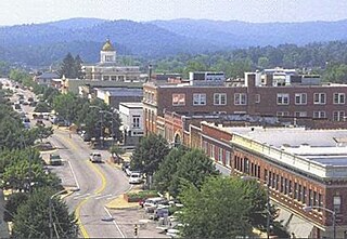
Mount Sterling, often written as Mt. Sterling, is a home rule-class city in Montgomery County, Kentucky, United States. The population was 7,558 as of the 2020 census, up from 6,895 in 2010. It is the county seat of Montgomery County and the principal city of the Mount Sterling micropolitan area.

<span class="mw-page-title-main">Graham, North Carolina</span> City in North Carolina, United States

Graham is a city in Alamance County, North Carolina, United States. It is part of the Burlington, North Carolina Metropolitan Statistical Area. As of the 2020 census the population was 17,153. It is the county seat of Alamance County.

<span class="mw-page-title-main">Oxford, North Carolina</span> Town in North Carolina, United States

Oxford is a town in Granville County, North Carolina, United States, with a population of 8,628 as of the 2020 census. It is the county seat of Granville County.

<span class="mw-page-title-main">Hendersonville, North Carolina</span> City in North Carolina, United States

Hendersonville is a city in and the county seat of Henderson County, North Carolina, United States, located 22 miles (35 km) south of Asheville. Like the county, the city is named for 19th-century North Carolina Supreme Court Chief Justice Leonard Henderson.

<span class="mw-page-title-main">Lincolnton, North Carolina</span> City in North Carolina, United States

Lincolnton is a city in Lincoln County, North Carolina, United States within the Charlotte metropolitan area. The population was 10,486 at the 2010 census. Lincolnton is northwest of Charlotte, on the South Fork of the Catawba River. The city is the county seat of Lincoln County.

<span class="mw-page-title-main">Allendale, South Carolina</span> Town in South Carolina, United States

Allendale is a town in and the county seat of Allendale County, South Carolina, United States. The population was 3,482 at the 2010 census, a decline from 4,052 in 2000.

<span class="mw-page-title-main">Powdersville, South Carolina</span> CDP in South Carolina, United States

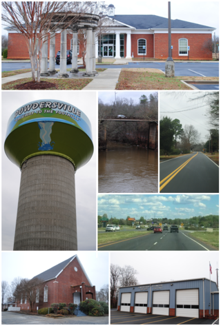
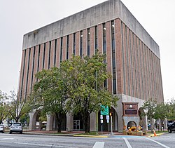
Powdersville is a census-designated place (CDP) in Anderson County, South Carolina. The population was 10,025 at the 2020 census,.

<span class="mw-page-title-main">Barnwell, South Carolina</span> City in South Carolina, United States

Barnwell is a city in and county seat of Barnwell County, South Carolina, United States, located along U.S. Route 278. The population was 4,750 at the 2010 census.

<span class="mw-page-title-main">Cheraw, South Carolina</span> Town in South Carolina, United States

Cheraw is a town on the Pee Dee River in Chesterfield County, South Carolina, United States. The population was 5,040 at the 2020 census. The greater Cheraw area in the zip code 29520 has a population of 13,689 according to the 2019 ACS data. It has been nicknamed "The Prettiest Town in Dixie".

<span class="mw-page-title-main">Society Hill, South Carolina</span> Town in South Carolina, United States

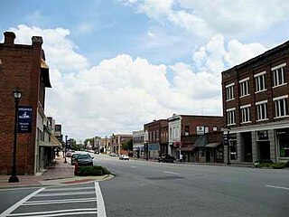
Society Hill is a town in Darlington County, South Carolina, United States alongside the Pee Dee River. It is the oldest community in Darlington County and one of the first towns founded in South Carolina. The town was once the intellectual center of the Pee Dee region. However, the town's fortunes declined in the 19th century after rivers became less important as means of transportation. It is part of the Florence Metropolitan Statistical Area.

<span class="mw-page-title-main">Kershaw, South Carolina</span> Town in South Carolina, United States

Kershaw is a town in Lancaster County, South Carolina, United States. It was incorporated in 1888. As of the 2010 census, the population was 1,803, and as of 2019 the estimated population was 2,321. The Haile Gold Mine, where gold was discovered in 1825, is 3 miles (5 km) from town and was at one time the largest single producer of gold in the Appalachian region.

<span class="mw-page-title-main">Lancaster, South Carolina</span> City in South Carolina, United States

The city of Lancaster is the county seat of Lancaster County, South Carolina, United States, located in the Charlotte Metropolitan Area. As of the United States Census of 2010, the city population was 8,526. The city was named after the famous House of Lancaster.

<span class="mw-page-title-main">Laurens, South Carolina</span> City in South Carolina, United States

Laurens is a city in Laurens County, South Carolina, United States. The population was 9,139 at the 2010 census. It is the county seat of Laurens County.

<span class="mw-page-title-main">Bishopville, South Carolina</span> Town in South Carolina, United States

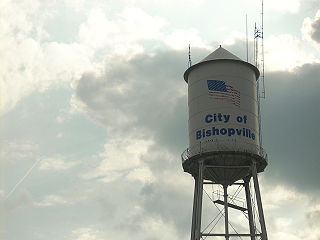
Bishopville is a town in Lee County, South Carolina, United States. The population was 3,471 at the 2010 census. It is the county seat of Lee County.

<span class="mw-page-title-main">Newberry, South Carolina</span> City in South Carolina, United States

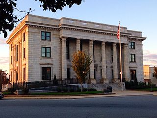
Newberry is a city in Newberry County, South Carolina, United States, in the Piedmont 43 miles northwest of Columbia. The charter was adopted in 1894. The population was 10,277 at the 2010 census. It is the county seat of Newberry County; at one time it was called Newberry Courthouse.

<span class="mw-page-title-main">York, South Carolina</span> City in South Carolina, United States

York is a city in and county seat of York County, South Carolina, United States. The population was approximately 6,985 at the 2000 census and up to 7,736 at the 2010 census. York is located approximately 27 miles (43 km) southwest of Charlotte, North Carolina and 13 miles (21 km) west of Rock Hill, South Carolina.

References

  1. "ArcGIS REST Services Directory". United States Census Bureau. Retrieved October 15, 2022.
  2. 1 2 "Census Population API". United States Census Bureau. Retrieved October 15, 2022.
  3. 1 2 "U.S. Census website". United States Census Bureau . Retrieved January 31, 2008.
  4. "US Board on Geographic Names". United States Geological Survey. October 25, 2007. Retrieved January 31, 2008.
  5. "Find a County". National Association of Counties. Archived from the original on May 31, 2011. Retrieved June 7, 2011.
  6. 1 2 "Geographic Identifiers: 2010 Demographic Profile Data (G001): Darlington city, South Carolina". U.S. Census Bureau, American Factfinder. Archived from the original on February 13, 2020. Retrieved January 5, 2016.
  7. Darlington County, A Pictorial History, The Donning Co., 1986.
  8. This history was copied out of Darlington District, S.C. Cemetery Survey Volume One, compiled by members of the Old Darlington District Chapter of the South Carolina Genealogical Society. Copyright 1993.
  9. "National Register Information System". National Register of Historic Places . National Park Service. July 9, 2010.
  10. "US Gazetteer files: 2010, 2000, and 1990". United States Census Bureau. February 12, 2011. Retrieved April 23, 2011.
  11. 1 2 3 4 5 6 7 8 "NOAA Online Weather Data – NWS Wilmington". National Weather Service. Retrieved September 4, 2023.
  12. 1 2 "U.S. Climate Normals Quick Access – Station: Darlington, SC". National Oceanic and Atmospheric Administration. Retrieved September 4, 2023.
  13. "Explore Census Data". data.census.gov. Retrieved December 7, 2021.
  14. "South Carolina libraries and archives". SCIWAY. Retrieved June 8, 2019.
  15. Benson, Kevin; Weber, Jennifer (2012). "Full Spectrum Operations in the Homeland: A 'Vision' of the Future". Small Wars Journal . Small Wars Foundation. Retrieved November 19, 2012.
  16. "Editorial: The Civil War of 2016". The Washington Times . August 7, 2012. Retrieved November 19, 2012.
  17. Peck, Michael (November 15, 2012). "How the U.S. Military Would Crush a Tea Party Rebellion". Forbes . Retrieved November 19, 2012.
  18. "Princess Python Powers, Enemies, History | Marvel". Marvel Entertainment. Retrieved January 13, 2023.
  19. Wiacek, Stephen; Bray, Adam; Lee, Stan (2019). Marvel Encyclopedia (New ed.). New York: DK Publishing. p. 275. ISBN   978-1465478900.
  20. "Gloria Hines by ten for Darlington Mayor". November 24, 2015.
  21. "Darlington swears in its first African American mayor". January 5, 2016.
  22. "Darlington mayor says she accomplished a lot in 4 years". December 4, 2019.
  23. "Orlando Hudson Stats". Baseball Almanac. Retrieved December 21, 2012.